RELAZIONE GEOLOGICA - Portale di cartografia on-line - Provincia ...
RELAZIONE GEOLOGICA - Portale di cartografia on-line - Provincia ...
RELAZIONE GEOLOGICA - Portale di cartografia on-line - Provincia ...

You also want an ePaper? Increase the reach of your titles
YUMPU automatically turns print PDFs into web optimized ePapers that Google loves.
Stu<str<strong>on</strong>g>di</str<strong>on</strong>g>o <str<strong>on</strong>g>di</str<strong>on</strong>g> Geologia e Geotecnica<br />
Dr. Geol. Amedeo Dor<str<strong>on</strong>g>di</str<strong>on</strong>g><br />
Si determina così un andamento dei flussi idrici sotterranei essenzialmente<br />
coincidente c<strong>on</strong> l’impostazi<strong>on</strong>e dei bacini idrografici <str<strong>on</strong>g>di</str<strong>on</strong>g> superficie, c<strong>on</strong> assi drenanti<br />
che segu<strong>on</strong>o l’andamento del Gi<strong>on</strong>a; i deflussi delle acque avviene verso il Lago<br />
Maggiore, che rappresenta il recapito finale <str<strong>on</strong>g>di</str<strong>on</strong>g> tutte le falde dei bacini c<strong>on</strong>siderati.<br />
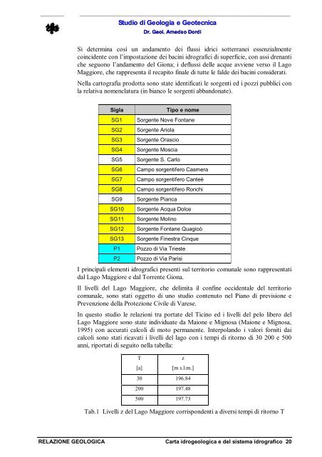
Nella <str<strong>on</strong>g>cartografia</str<strong>on</strong>g> prodotta s<strong>on</strong>o state identificati le sorgenti ed i pozzi pubblici c<strong>on</strong><br />
la relativa nomenclatura (in bianco le sorgenti abband<strong>on</strong>ate).<br />
Sigla Tipo e nome<br />
SG1 Sorgente Nove F<strong>on</strong>tane<br />
SG2 Sorgente Ariola<br />
SG3 Sorgente Orascio<br />
SG4 Sorgente Moscia<br />
SG5 Sorgente S. Carlo<br />
SG6 Campo sorgentifero Casmera<br />
SG7 Campo sorgentifero Canteè<br />
SG8 Campo sorgentifero R<strong>on</strong>chi<br />
SG9 Sorgente Pianca<br />
SG10 Sorgente Acqua Dolce<br />
SG11 Sorgente Molino<br />
SG12 Sorgente F<strong>on</strong>tane Quagioò<br />
SG13 Sorgente Finestra Cinque<br />
P1 Pozzo <str<strong>on</strong>g>di</str<strong>on</strong>g> Via Trieste<br />
P2 Pozzo <str<strong>on</strong>g>di</str<strong>on</strong>g> Via Parisi<br />
I principali elementi idrografici presenti sul territorio comunale s<strong>on</strong>o rappresentati<br />
dal Lago Maggiore e dal Torrente Gi<strong>on</strong>a.<br />
Il livelli del Lago Maggiore, che delimita il c<strong>on</strong>fine occidentale del territorio<br />
comunale, s<strong>on</strong>o stati oggetto <str<strong>on</strong>g>di</str<strong>on</strong>g> uno stu<str<strong>on</strong>g>di</str<strong>on</strong>g>o c<strong>on</strong>tenuto nel Piano <str<strong>on</strong>g>di</str<strong>on</strong>g> previsi<strong>on</strong>e e<br />
Prevenzi<strong>on</strong>e della Protezi<strong>on</strong>e Civile <str<strong>on</strong>g>di</str<strong>on</strong>g> Varese.<br />
In questo stu<str<strong>on</strong>g>di</str<strong>on</strong>g>o le relazi<strong>on</strong>i tra portate del Ticino ed i livelli del pelo libero del<br />
Lago Maggiore s<strong>on</strong>o state in<str<strong>on</strong>g>di</str<strong>on</strong>g>viduate da Mai<strong>on</strong>e e Mignosa (Mai<strong>on</strong>e e Mignosa,<br />
1995) c<strong>on</strong> accurati calcoli <str<strong>on</strong>g>di</str<strong>on</strong>g> moto permanente. Interpolando i valori forniti dai<br />
calcoli s<strong>on</strong>o stati ricavati i livelli del lago c<strong>on</strong> i tempi <str<strong>on</strong>g>di</str<strong>on</strong>g> ritorno <str<strong>on</strong>g>di</str<strong>on</strong>g> 30 200 e 500<br />
anni, riportati <str<strong>on</strong>g>di</str<strong>on</strong>g> seguito nella tabella:<br />
T<br />
[a]<br />
<str<strong>on</strong>g>RELAZIONE</str<strong>on</strong>g> <str<strong>on</strong>g>GEOLOGICA</str<strong>on</strong>g> Carta idrogeologica e del sistema idrografico 20<br />
z<br />
[m s.l.m.]<br />
30 196.84<br />
200 197.48<br />
500 197.73<br />
Tab.1 Livelli z del Lago Maggiore corrisp<strong>on</strong>denti a <str<strong>on</strong>g>di</str<strong>on</strong>g>versi tempi <str<strong>on</strong>g>di</str<strong>on</strong>g> ritorno T