geologia della piana del fucino - Idrogeologia quantitativa
geologia della piana del fucino - Idrogeologia quantitativa
geologia della piana del fucino - Idrogeologia quantitativa

Create successful ePaper yourself
Turn your PDF publications into a flip-book with our unique Google optimized e-Paper software.
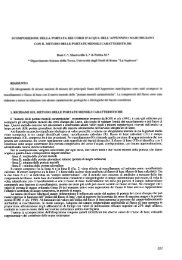
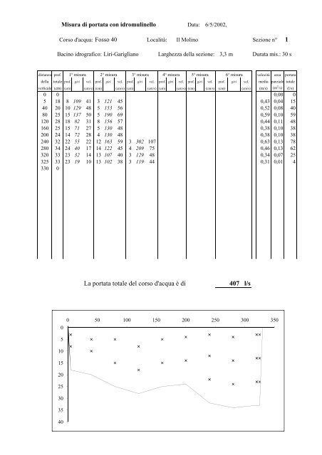
Misura di portata con idromulinello Data: 6/5/2002,<br />
Corso d'acqua: Fosso 40 Località: Il Molino Sezione n° 1<br />
Bacino idrografico: Liri-Garigliano Larghezza <strong><strong>del</strong>la</strong> sezione: 3,3 m Durata mis.: 30 s<br />
distanza prof. 1° misura 2° misura 3° misura 4° misura 5° misura 6° misura velocità area portata<br />
<strong><strong>del</strong>la</strong> totale prof. giri vel. prof. giri vel. prof. giri vel. prof. giri vel. prof. giri vel. prof. giri vel. media parziale totale<br />
verticale (cm) (cm) (cm/s) (cm) (cm/s) (cm) (cm/s) (cm) (cm/s) (cm) (cm/s) (cm) (cm/s) (m/s) (m 2 /s) (l/s)<br />
0 0 0,00 0<br />
5 18 8 109 41 33 121 45 45 0,43 0,04 15<br />
40 20 10 129 48 5 153 56 0,52 0,08 40<br />
80 25 15 137 50 5 190 69 0,59 0,10 59<br />
120 28 18 82 31 8 156 57 0,44 0,11 48<br />
160 25 15 71 27 5 130 48 0,38 0,10 38<br />
200 24 14 72 28 4 130 48 0,38 0,10 38<br />
240 32 22 55 22 12 163 59 3 302 107 0,63 0,13 78<br />
280 34 24 40 17 14 122 45 4 209 75 0,46 0,13 62<br />
320 33 23 32 14 13 107 40 40 3 129 48 034 0,34 007 0,07 25<br />
325 33 23 19 10 13 102 38 3 119 44 0,31 0,01 4<br />
330 0<br />
0<br />
5<br />
10<br />
15<br />
20<br />
25<br />
30<br />
35<br />
40<br />
La portata totale <strong>del</strong> corso d'acqua è di 407 l/s<br />
0 50 100 150 200 250 300 350