Annexures - WAPCOS - Ministry of Environment and Forests
Annexures - WAPCOS - Ministry of Environment and Forests
Annexures - WAPCOS - Ministry of Environment and Forests

Create successful ePaper yourself
Turn your PDF publications into a flip-book with our unique Google optimized e-Paper software.
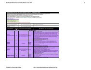
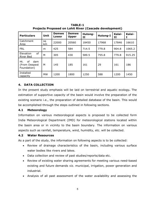
Particulars<br />
Catchment<br />
Area<br />
TABLE-1<br />
Projects Proposed on Lohit River (Cascade development)<br />
Unit<br />
sq<br />
km<br />
Demwe<br />
Lower<br />
Demwe<br />
Upper<br />
Hutong-<br />
II<br />
Hutong-I<br />
Kalai-<br />
II<br />
Kalai-<br />
I<br />
22000 20560 18450 17968 17846 16610<br />
FRL m 425 584 714.5 779.8 904.8 1065.2<br />
Elevation<br />
River Bed<br />
<strong>of</strong><br />
M 305 430 589.5 755.8 779.8 915.25<br />
Ht. <strong>of</strong> dam<br />
(From Deepest<br />
Foundation)<br />
Installed<br />
capacity<br />
M 145 185 161 29 161 186<br />
MW 1200 1800 1250 588 1200 1450<br />
4. DATA COLLECTION<br />
In the present study emphasis will be laid on terrestrial <strong>and</strong> aquatic ecology. The<br />
estimation <strong>of</strong> supportive capacity <strong>of</strong> the basin would involve the preparation <strong>of</strong> the<br />
existing scenario i.e., the preparation <strong>of</strong> detailed database <strong>of</strong> the basin. This would<br />
be accomplished through the steps outlined in following sections.<br />
4.1 Meteorology<br />
Information on various meteorological aspects is proposed to be collected form<br />
India Meteorological Department (IMD) for meteorological stations located within<br />
the basin area or in vicinity to the basin boundary. The information on various<br />
aspects such as rainfall, temperature, wind, humidity, etc. will be collected.<br />
4.2 Water Resources<br />
As a part <strong>of</strong> the study, the information on following aspects is to be collected:<br />
Review <strong>of</strong> drainage characteristics <strong>of</strong> the basin, including various surface<br />
water bodies like rivers <strong>and</strong> lakes.<br />
Data collection <strong>and</strong> review <strong>of</strong> past studies/reports/data etc.<br />
Review <strong>of</strong> existing water sharing agreements for meeting various need-based<br />
existing <strong>and</strong> future dem<strong>and</strong>s viz. municipal, irrigation, power generation <strong>and</strong><br />
industrial.<br />
Analysis <strong>of</strong> all past assessment <strong>of</strong> the water availability <strong>and</strong> assessing the<br />
5