Scheda di censimento delle aree dismesse del territorio lombardo
Scheda di censimento delle aree dismesse del territorio lombardo
Scheda di censimento delle aree dismesse del territorio lombardo

Create successful ePaper yourself
Turn your PDF publications into a flip-book with our unique Google optimized e-Paper software.
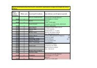
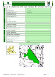
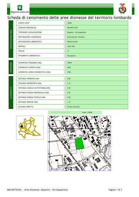
<strong>Scheda</strong> <strong>di</strong> <strong>censimento</strong> <strong><strong>del</strong>le</strong> <strong>aree</strong> <strong>di</strong>smesse <strong>del</strong> <strong>territorio</strong> <strong>lombardo</strong>CODICE ISTAT 12096COMUNE (PROVINCIA)MALNATE (VA)IDENTIFICAZIONE AREATOPONIMO LOCALIZAZZIONEDESTINAZIONE FUNZIONALEDESTINAZIONE URBANISTICAMAPPALIDeposito - Via GasparottoCommerciale EsclusivaPolifunzionale1442-1444FOGLIO11STRUMENTO URBANISTICOPrg vigenteESTENSIONESUPERFICIE FONDIARIA (MQ)SUPERFICIE COPERTA (MQ)SUPERFICIE LORDA PAVIMENTATA (MQ)1009934535180DISTANZA FERROVIA (KM)DISTANZA AEROPORTO (KM)0.842.15ACCESSIBILITA'DISTANZA CASELLO AUTOSTRADA (KM)DISTANZA STRADA PROVINCIALE (KM)DISTANZA STRADA STATALE (KM)6.180.470.09DISTANZA IDROVIE (KM)ACCESSO DIRETTO1.27Strada comunaleESTRATTO DA RASTERScala 1:10000MALNATE(VA) - Area Dismessa Deposito - Via Gasparotto Pagina 1 <strong>di</strong> 3