Scheda di censimento delle aree dismesse del territorio lombardo
Scheda di censimento delle aree dismesse del territorio lombardo
Scheda di censimento delle aree dismesse del territorio lombardo

You also want an ePaper? Increase the reach of your titles
YUMPU automatically turns print PDFs into web optimized ePapers that Google loves.
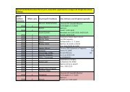
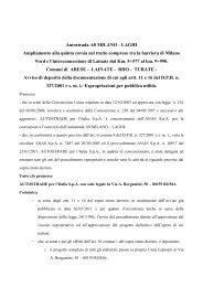
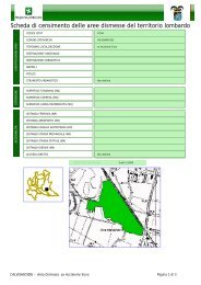
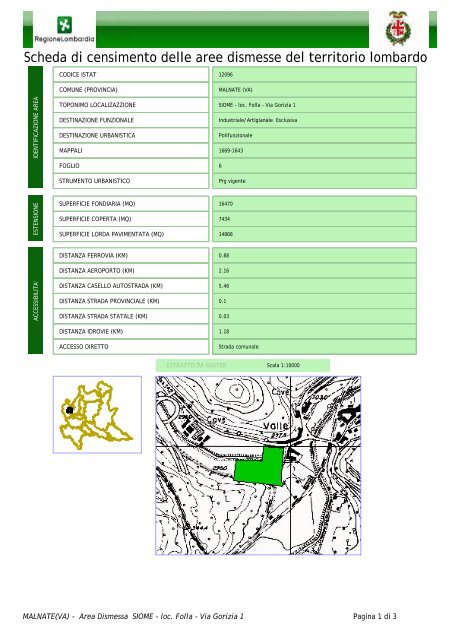
<strong>Scheda</strong> <strong>di</strong> <strong>censimento</strong> <strong><strong>del</strong>le</strong> <strong>aree</strong> <strong>di</strong>smesse <strong>del</strong> <strong>territorio</strong> <strong>lombardo</strong>CODICE ISTAT 12096COMUNE (PROVINCIA)MALNATE (VA)IDENTIFICAZIONE AREATOPONIMO LOCALIZAZZIONEDESTINAZIONE FUNZIONALEDESTINAZIONE URBANISTICAMAPPALISIOME - loc. Folla - Via Gorizia 1Industriale/Artigianale EsclusivaPolifunzionale1669-1643FOGLIO6STRUMENTO URBANISTICOPrg vigenteESTENSIONESUPERFICIE FONDIARIA (MQ)SUPERFICIE COPERTA (MQ)SUPERFICIE LORDA PAVIMENTATA (MQ)16470743414868DISTANZA FERROVIA (KM)DISTANZA AEROPORTO (KM)0.882.16ACCESSIBILITA'DISTANZA CASELLO AUTOSTRADA (KM)DISTANZA STRADA PROVINCIALE (KM)DISTANZA STRADA STATALE (KM)5.460.10.03DISTANZA IDROVIE (KM)ACCESSO DIRETTO1.18Strada comunaleESTRATTO DA RASTERScala 1:10000MALNATE(VA) - Area Dismessa SIOME - loc. Folla - Via Gorizia 1 Pagina 1 <strong>di</strong> 3