Vegetation and Soil Monitoring at Flin Flon, Manitoba
Vegetation and Soil Monitoring at Flin Flon, Manitoba
Vegetation and Soil Monitoring at Flin Flon, Manitoba

Create successful ePaper yourself
Turn your PDF publications into a flip-book with our unique Google optimized e-Paper software.
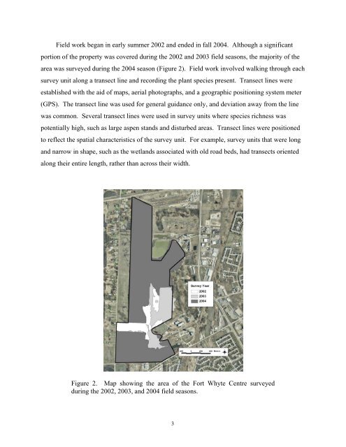
Field work began in early summer 2002 <strong>and</strong> ended in fall 2004. Although a significant<br />
portion of the property was covered during the 2002 <strong>and</strong> 2003 field seasons, the majority of the<br />
area was surveyed during the 2004 season (Figure 2). Field work involved walking through each<br />
survey unit along a transect line <strong>and</strong> recording the plant species present. Transect lines were<br />
established with the aid of maps, aerial photographs, <strong>and</strong> a geographic positioning system meter<br />
(GPS). The transect line was used for general guidance only, <strong>and</strong> devi<strong>at</strong>ion away from the line<br />
was common. Several transect lines were used in survey units where species richness was<br />
potentially high, such as large aspen st<strong>and</strong>s <strong>and</strong> disturbed areas. Transect lines were positioned<br />
to reflect the sp<strong>at</strong>ial characteristics of the survey unit. For example, survey units th<strong>at</strong> were long<br />
<strong>and</strong> narrow in shape, such as the wetl<strong>and</strong>s associ<strong>at</strong>ed with old road beds, had transects oriented<br />
along their entire length, r<strong>at</strong>her than across their width.<br />
Figure 2. Map showing the area of the Fort Whyte Centre surveyed<br />
during the 2002, 2003, <strong>and</strong> 2004 field seasons.<br />
3