Geology and Geochronology of the Island Lake Greenstone Belt ...
Geology and Geochronology of the Island Lake Greenstone Belt ...
Geology and Geochronology of the Island Lake Greenstone Belt ...
You also want an ePaper? Increase the reach of your titles
YUMPU automatically turns print PDFs into web optimized ePapers that Google loves.
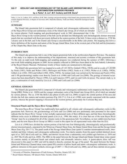
GS-17GEOLOGY AND GEOCHRONOLOGY OF THE ISLAND LAKE GREENSTONE BELT,NORTHWESTERN SUPERIOR PROVINCEby J. Parks 1 , S. Lin 1 , M.T. Corkery <strong>and</strong> D.W. Davis 2Parks, J., Lin, S., Corkery, M.T. <strong>and</strong> Davis, D.W. 2001: <strong>Geology</strong> <strong>and</strong> geochronology <strong>of</strong> <strong>the</strong> Isl<strong>and</strong> <strong>Lake</strong> greenstone belt, northwesternSuperior Province; in Report <strong>of</strong> Activities 2001, Manitoba Industry, Trade <strong>and</strong> Mines, Manitoba Geological Survey,p. 115-120.SUMMARYThe Isl<strong>and</strong> <strong>Lake</strong> greenstone belt is composed <strong>of</strong> volcanic <strong>and</strong> volcanogenic sedimentary rocks<strong>of</strong> <strong>the</strong> Hayes River Group <strong>and</strong> sedimentary rocks <strong>of</strong> <strong>the</strong> Isl<strong>and</strong> <strong>Lake</strong> Group, all <strong>of</strong> which are intrudedby various plutons. Field mapping <strong>and</strong> geochronological work in 2001 demonstrated that 1) <strong>the</strong>Hayes River Group in <strong>the</strong> western portion <strong>of</strong> <strong>the</strong> belt can be divided into lithologically <strong>and</strong> chronologically distinct structuralpanels that are correlated with those previously defined in <strong>the</strong> eastern portion <strong>of</strong> <strong>the</strong> belt; 2) <strong>the</strong>re exists a distinct ca. 2728 Mavolcanic unit in <strong>the</strong> belt; <strong>and</strong> 3) <strong>the</strong> Isl<strong>and</strong> <strong>Lake</strong> Group is unconformable on <strong>the</strong> Bella <strong>Lake</strong> pluton. The mapping also led to abetter definition <strong>of</strong> <strong>the</strong> location <strong>and</strong> nature <strong>of</strong> <strong>the</strong> Savage Isl<strong>and</strong> Shear Zone in <strong>the</strong> western part <strong>of</strong> <strong>the</strong> belt <strong>and</strong> <strong>the</strong> kinematics<strong>of</strong> <strong>the</strong> Chapin Bay Shear Zone in <strong>the</strong> area.INTRODUCTIONThe Isl<strong>and</strong> <strong>Lake</strong> greenstone belt is one <strong>of</strong> <strong>the</strong> largest greenstone belts in <strong>the</strong> northwestern Superior Province. The purpose<strong>of</strong> this study is to improve <strong>the</strong> underst<strong>and</strong>ing <strong>of</strong> <strong>the</strong> depositional, structural <strong>and</strong> tectonic evolution <strong>of</strong> this greenstone belt.To this end, an eight-week field-mapping <strong>and</strong> sampling program was conducted during <strong>the</strong> summer <strong>of</strong> 2001, following aone-week field-sampling program in 2000. Seven samples collected in 2000 have been dated at <strong>the</strong> Jack Satterly Laboratory<strong>of</strong> <strong>the</strong> Royal Ontario Museum. Preliminary results <strong>of</strong> <strong>the</strong>se studies are summarized in this paper.The Isl<strong>and</strong> <strong>Lake</strong> greenstone belt was mapped at a scale <strong>of</strong> 1:63 360 by Godard (1963a, 1963b), <strong>and</strong> at a scale <strong>of</strong> 1:20 000by Neale (1981), Neale <strong>and</strong> Weber (1981), McGregor <strong>and</strong> Weber (1982), Neale et al. (1982), Weber et al. (1982a, 1982b),Gilbert et al. (1982, 1983) <strong>and</strong> Gilbert (1984, 1985a, 1985b). An isotope study was carried out by Stevenson <strong>and</strong> Turek (1992),<strong>and</strong> U-Pb geochronology studies were done by Turek et al. (1986) <strong>and</strong> Corfu <strong>and</strong> Lin (2000). The geology <strong>of</strong> mineral occurrenceshas been described by Theyer (1998), Lin <strong>and</strong> Cameron (1997), <strong>and</strong> Lin <strong>and</strong> Corfu (in press). The current study is, inpart, a continuation <strong>of</strong> work started by Lin et al. (1998) <strong>and</strong> Corfu <strong>and</strong> Lin (2000).GENERAL GEOLOGYThe Isl<strong>and</strong> <strong>Lake</strong> greenstone belt is composed <strong>of</strong> volcanic <strong>and</strong> volcanogenic sedimentary rocks mapped as <strong>the</strong> Hayes RiverGroup (HRG; Weber et al., 1982b) <strong>and</strong> <strong>the</strong> younger sedimentary rocks <strong>of</strong> <strong>the</strong> Isl<strong>and</strong> <strong>Lake</strong> Group (ILG), all <strong>of</strong> which are intrudedby various plutons. The ca. 2744 Ma Bella <strong>Lake</strong> pluton (Corfu <strong>and</strong> Lin, 2000) occupies <strong>the</strong> central portion <strong>of</strong> <strong>the</strong> area <strong>and</strong>divides <strong>the</strong> belt into eastern <strong>and</strong> western portions (Fig. GS-17-1). Lin et al. (1998) were mostly concerned with <strong>the</strong> easternportion, whereas <strong>the</strong> present mapping is focussed on <strong>the</strong> western portion, particularly <strong>the</strong> Cochrane Bay area.Structural Panels <strong>and</strong> <strong>the</strong> Hayes River Group (HRG)The term Hayes River ‘Group’ has traditionally been applied to all volcanic <strong>and</strong> volcanogenic sedimentary rocks in thisgreenstone belt. However, <strong>the</strong> geochronology <strong>of</strong> Corfu <strong>and</strong> Lin (2000) <strong>and</strong> new preliminary data presented in this reportindicate that <strong>the</strong> Hayes River ‘Group’ in fact includes supracrustal rocks <strong>of</strong> three different ages, <strong>and</strong> that <strong>the</strong>se chronologicallydifferent rocks occur in different structural panels (Lin et al., 1998; this study). It is clear that use <strong>of</strong> <strong>the</strong> term Hayes River‘Group’ must be re-evaluated for all <strong>of</strong> <strong>the</strong> volcanic rocks in this greenstone belt. Never<strong>the</strong>less, no new subdivision has beenmade, <strong>and</strong> <strong>the</strong> term Hayes River Group (or HRG) is used in this report for all supracrustal rocks older than <strong>the</strong> ILG.Lin et al. (1998) have divided <strong>the</strong> eastern portion <strong>of</strong> <strong>the</strong> belt into four lithologically, chronologically <strong>and</strong> geochemicallydistinct structural panels, separated by <strong>the</strong> Whiteway Channel Shear Zone, <strong>the</strong> Harper Isl<strong>and</strong> Shear Zone <strong>and</strong> <strong>the</strong> Savage Isl<strong>and</strong>Shear Zone (Fig. GS-17-1). The panel south <strong>of</strong> <strong>the</strong> Savage Isl<strong>and</strong> Shear Zone (panel I) contains metamorphosed mafic, intermediate<strong>and</strong> felsic volcanic <strong>and</strong> volcanogenic sedimentary rocks. Two dacite samples from this panel yielded identical zirconages <strong>of</strong> ca. 2852 Ma (Corfu <strong>and</strong> Lin, 2000), <strong>and</strong> detrital zircons from a sedimentary rock yielded ages between ca. 2858 <strong>and</strong>ca. 2847 Ma (Corfu <strong>and</strong> Lin, 2000). The HRG in <strong>the</strong> panel between <strong>the</strong> Savage Isl<strong>and</strong> <strong>and</strong> Harper Isl<strong>and</strong> shear zones (panelII) consists mainly <strong>of</strong> pillowed basalt <strong>and</strong> related mafic <strong>and</strong> ultramafic intrusive rocks. A quartz-phyric felsic tuff wasdiscovered in this panel in 2001 <strong>and</strong> will be dated to directly constrain <strong>the</strong> age <strong>of</strong> <strong>the</strong> panel. The panel between <strong>the</strong> HarperIsl<strong>and</strong> <strong>and</strong> Whiteway Channel shear zones (panel III) consists <strong>of</strong> pillow basalt <strong>and</strong> minor volcanogenic sedimentary rocks. Agabbroic intrusion in this panel yielded a zircon age <strong>of</strong> 2807 ± 1 Ma (Corfu <strong>and</strong> Lin, 2000), <strong>and</strong> all three detrital zircon grains1University <strong>of</strong> Waterloo, Department <strong>of</strong> Earth Sciences, Waterloo, Ontario N2L 3G12Royal Ontario Museum, 100 Queen's Park, Toronto, Ontario M5S 2C6115
Figure GS-17-1: Simplified geology <strong>of</strong> <strong>the</strong> Isl<strong>and</strong> <strong>Lake</strong> greenstone belt.dated so far from a sedimentary rock yielded essentially identical ages <strong>of</strong> ca. 2897 Ma (sample 859, this study). The panelnorth <strong>of</strong> <strong>the</strong> Whiteway Channel Shear Zone (panel IV) consists <strong>of</strong> amphibolite-grade mafic <strong>and</strong> ultramafic volcanic rocks. Nomaterial suitable for U-Pb dating has been found in this panel.In <strong>the</strong> western portion <strong>of</strong> <strong>the</strong> belt, mapping in 2001 has led to <strong>the</strong> recognition <strong>of</strong> three lithologically <strong>and</strong> chronologicallydistinct structural panels: <strong>the</strong> southwestern, central <strong>and</strong> nor<strong>the</strong>astern panels (Fig. GS-17-1). The southwestern panel occurs to<strong>the</strong> southwest <strong>of</strong> <strong>the</strong> Savage Isl<strong>and</strong> Shear Zone, contains pillowed <strong>and</strong> massive basalt, felsic volcanic rocks <strong>and</strong> volcanogenicsedimentary rocks, <strong>and</strong> can be traced unambiguously into panel I in <strong>the</strong> eastern portion <strong>of</strong> <strong>the</strong> belt. A dacite sample from <strong>the</strong>southwestern panel, collected west <strong>of</strong> Linklater Isl<strong>and</strong>, has yielded a zircon age <strong>of</strong> 2852 ± 1 Ma (sample 839, this study). Thenor<strong>the</strong>astern panel is exposed in <strong>the</strong> eastern part <strong>of</strong> Cochrane Bay <strong>and</strong> consists <strong>of</strong> sedimentary rocks, an older leucotonaliteunit <strong>and</strong> an older granodiorite unit. The leucotonalite has a zircon age <strong>of</strong> 2886 ± 15 Ma (Turek et al., 1986), <strong>and</strong> <strong>the</strong> granodioritehas a zircon age <strong>of</strong> 2894 ± 1 Ma (sample JP00-04, this study). We tentatively correlate this panel with panel III in <strong>the</strong>eastern portion <strong>of</strong> <strong>the</strong> greenstone belt, based on similar zircon ages <strong>and</strong> <strong>the</strong> fact that <strong>the</strong> two panels are approximately alongstrike.The central panel occurs in <strong>the</strong> Bunny Isl<strong>and</strong> area (Fig. GS-17-1) <strong>and</strong> contains pillowed <strong>and</strong> massive basalt, <strong>and</strong> relatedfelsic volcanic rocks <strong>and</strong> subvolcanic porphyry. The felsic volcanic rock yielded a zircon age <strong>of</strong> ca. 2728 Ma (sample 899,this study). This panel is thus distinctly younger than <strong>the</strong> southwestern panel (or panel I in <strong>the</strong> east). Field mapping shows thatthis panel has sheared contacts with <strong>the</strong> Linklater porphyry <strong>and</strong> <strong>the</strong> Isl<strong>and</strong> <strong>Lake</strong> Group (Fig. GS-17-1). We suspect that thispanel can be correlated with panel II in <strong>the</strong> east, based on similar lithological association <strong>and</strong> similar location relative to o<strong>the</strong>rpanels. Additional geochronological <strong>and</strong> geochemical work (especially geochronological work on <strong>the</strong> newly discoveredfelsic tuff in panel II) will help to test this correlation.Isl<strong>and</strong> <strong>Lake</strong> Group (ILG)The Isl<strong>and</strong> <strong>Lake</strong> Group (ILG) unconformably overlies <strong>the</strong> Hayes River Group <strong>and</strong> is composed <strong>of</strong> conglomerate, s<strong>and</strong>stone<strong>and</strong> turbidite sequences. Detrital zircon work by Corfu <strong>and</strong> Lin (2000) on two wacke samples from <strong>the</strong> upper part <strong>of</strong> <strong>the</strong>sequence shows that this part <strong>of</strong> <strong>the</strong> sequence is younger than ca. 2712 Ma. However, <strong>the</strong> lower part <strong>of</strong> <strong>the</strong> sequence wasbelieved to be intruded by <strong>the</strong> ca. 2744 Ma Bella <strong>Lake</strong> Pluton (Lin et al., 1998; Corfu <strong>and</strong> Lin, 2000); if correct, this indicates116
Figure GS-17-3: Foliated gabbro in <strong>the</strong>Savage Isl<strong>and</strong> Shear Zone. Foliation ingabbro is parallel to <strong>the</strong> dashed line in <strong>the</strong>photo.Figure GS-17-4: Strongly deformed conglomerateunit in <strong>the</strong> Chapin Bay ShearZone. This unit can be traced laterally intoareas where <strong>the</strong> clasts are rounded <strong>and</strong>less deformed.Figure GS-17-5: Sheared porphyroclasts<strong>and</strong> mylonitic texture <strong>of</strong> <strong>the</strong> Chapin BayShear Zone in <strong>the</strong> Chapin Bay tonalite.Asymmetric tails indicate sinistral movement.118
elt. So far, two dykes from <strong>the</strong> eastern portion <strong>of</strong> <strong>the</strong> greenstone belt have been successfully dated for this purpose. In <strong>the</strong>Harper Isl<strong>and</strong> Shear Zone, an approximately 15 m wide late syntectonic tonalite dyke has yielded a zircon age <strong>of</strong> 2722 ± 1.2Ma (sample 684, this study). The dyke is weakly foliated <strong>and</strong> contains xenoliths <strong>of</strong> more strongly foliated mafic volcanicrocks. South <strong>of</strong> <strong>the</strong> Savage Isl<strong>and</strong> Shear Zone in panel I, a postkinematic quartz-porphyry dyke yielded a preliminary zirconage <strong>of</strong> 2723 ± 1.8 Ma (sample JP00-06, this study). The latter dyke is unfoliated <strong>and</strong> cuts a strong foliation in deformed maficvolcanic rocks (Fig. GS-17-6). Detailed work by Lin et al. (1998) showed that this foliation predates <strong>the</strong> Savage Isl<strong>and</strong> ShearZone.Figure GS-17-6: Coarse-grained felsic dykecutting foliation in strongly deformed maficvolcanic rocks.CONCLUSIONS AND FUTURE WORKThe Hayes River Group within <strong>the</strong> Isl<strong>and</strong> <strong>Lake</strong> greenstone belt can be divided into lithologically <strong>and</strong> geochronologicallydistinct structural panels that can be correlated across <strong>the</strong> entire belt. The central panel in <strong>the</strong> west consists <strong>of</strong> distinct volcanicrocks that are ca. 2728 Ma in age, much younger than o<strong>the</strong>r dated rocks <strong>of</strong> <strong>the</strong> Hayes River Group. The use <strong>of</strong> <strong>the</strong> term HayesRiver Group for all volcanic <strong>and</strong> volcanogenic rocks in this greenstone belt needs to be re-evaluated. The Isl<strong>and</strong> <strong>Lake</strong> Groupis confirmed to have an unconformable contact with <strong>the</strong> Bella <strong>Lake</strong> pluton.The western segment <strong>of</strong> <strong>the</strong> Savage Isl<strong>and</strong> Shear Zone is kinematically complicated <strong>and</strong> shows evidence for both dextral<strong>and</strong> sinistral shearing. The Chapin Bay Shear Zone is an extensive structure along <strong>the</strong> nor<strong>the</strong>rn edge <strong>of</strong> <strong>the</strong> western part <strong>of</strong> <strong>the</strong>map area <strong>and</strong> has experienced strong deformation with a sinistral strike-slip component <strong>and</strong> a north-over-south dip-slipcomponent.To fur<strong>the</strong>r constrain <strong>the</strong> geological evolution <strong>of</strong> <strong>the</strong> Isl<strong>and</strong> <strong>Lake</strong> greenstone belt, additional U-Pb analyses will be done at<strong>the</strong> Jack Satterly Laboratory <strong>of</strong> <strong>the</strong> Royal Ontario Museum. Geochemical analyses, including Sm-Nd work, are also plannedto help characterize <strong>the</strong> different panels <strong>and</strong> test <strong>the</strong> correlation <strong>of</strong> <strong>the</strong> panels from east to west. Detailed microstructural workwill be conducted on samples taken this summer. In particular, work will be done to determine <strong>the</strong> sequence <strong>of</strong> movementson <strong>the</strong> western segment <strong>of</strong> <strong>the</strong> Savage Isl<strong>and</strong> Shear Zone <strong>and</strong> to confirm <strong>the</strong> sense <strong>of</strong> shear along <strong>the</strong> Chapin Bay Shear Zone.ACKNOWLEDGMENTSFunding for this project has been generously supplied by <strong>the</strong> Manitoba Geological Survey, LITHOPROBE, <strong>the</strong> Nor<strong>the</strong>rnScientific Training Program <strong>and</strong> <strong>the</strong> University <strong>of</strong> Waterloo. <strong>Geochronology</strong> analyses were done at <strong>the</strong> Jack SatterlyLaboratory <strong>of</strong> <strong>the</strong> Royal Ontario Museum (ROM). J. Parks would like to thank H. Zwanzig for reviewing this manuscript, <strong>the</strong>staff at <strong>the</strong> ROM for <strong>the</strong>ir help, Scott Snider for his invaluable field assistance, Neill Br<strong>and</strong>son for logistical support, <strong>and</strong> manyfriends at Isl<strong>and</strong> <strong>Lake</strong> for <strong>the</strong>ir hospitality over <strong>the</strong> summer.REFERENCESCorfu, F. <strong>and</strong> Lin, S. 2000: <strong>Geology</strong> <strong>and</strong> U-Pb geochronology <strong>of</strong> <strong>the</strong> Isl<strong>and</strong> <strong>Lake</strong> greenstone belt, northwestern SuperiorProvince, Manitoba; Canadian Journal <strong>of</strong> Earth Sciences, v. 37, p. 1275–1286.Gilbert, H.P. 1984: Loonfoot Isl<strong>and</strong>; Manitoba Energy <strong>and</strong> Mines, Mineral Resources, Preliminary Map 1984I-1, scale1:20 000.Gilbert, H.P. 1985a: Loonfoot Isl<strong>and</strong>; Manitoba Energy <strong>and</strong> Mines, Geological Services/Mines Branch, Preliminary Map1985I-3, scale 1:20 000.119
Gilbert, H.P. 1985b: Isl<strong>and</strong> <strong>Lake</strong>; Manitoba Energy <strong>and</strong> Mines, Geological Services/Mines Branch, Preliminary Map 1985I-3,scale 1:20 000.Gilbert, H.P., Neale, K.L., Weber, W., Corkery, M.T. <strong>and</strong> McGregor, C.R. 1982: Isl<strong>and</strong> <strong>Lake</strong>; Manitoba Department <strong>of</strong> Energy<strong>and</strong> Mines, Mineral Resources Division, Preliminary Map 1982I-4, scale 1:20 000.Gilbert, H.P., Neale, K.L., Weber, W., Corkery, M.T. <strong>and</strong> McGregor, C.R. 1983: Isl<strong>and</strong> <strong>Lake</strong>; Manitoba Department <strong>of</strong> Energy<strong>and</strong> Mines, Mineral Resources Division, Preliminary Map 1983I-1, scale 1:20 000.Godard, J.D. 1963a: Isl<strong>and</strong> <strong>Lake</strong>; Manitoba Department <strong>of</strong> Mines <strong>and</strong> Natural Resources, Mines Branch, Map 59-3A, scale1: 63 360.Godard, J.D. 1963b: Isl<strong>and</strong> <strong>Lake</strong>; Manitoba Department <strong>of</strong> Mines <strong>and</strong> Natural Resources, Mines Branch, Map 59-3B, scale1: 63 360.Lin, S. <strong>and</strong> Corfu, F. in press. Structural setting <strong>and</strong> geochronology <strong>of</strong> auriferous quartz veins at <strong>the</strong> High Rock Isl<strong>and</strong> golddeposit, northwestern Superior Province; Economic <strong>Geology</strong>.Lin, S. <strong>and</strong> Cameron, H.D.M. 1997: Structural setting <strong>of</strong> <strong>the</strong> Au-bearing quartz veins at <strong>the</strong> Henderson Isl<strong>and</strong> gold deposit(Ministik Mine), Isl<strong>and</strong> <strong>Lake</strong>, Manitoba; in Report <strong>of</strong> Activities 1997, Manitoba Energy <strong>and</strong> Mines, GeologicalServices, p. 6–12.Lin, S., Cameron, H.D.M., Syme, E.C. <strong>and</strong> Corfu, F. 1998: Geological investigation in <strong>the</strong> Isl<strong>and</strong> <strong>Lake</strong> greenstone belt, northwesternSuperior Province (parts <strong>of</strong> NTS 53E/15 <strong>and</strong> 16): in Report <strong>of</strong> Activities 1998, Manitoba Energy <strong>and</strong> Mines,Geological Services, p. 78–87.McGregor, C.R. <strong>and</strong> Weber, W. 1982: St. Theresa Point; Manitoba Department <strong>of</strong> Energy <strong>and</strong> Mines, Mineral ResourcesDivision, Preliminary Map 1982I-3, scale 1: 20 000.Neale, K.L. 1981: Isl<strong>and</strong> <strong>Lake</strong>–Sinclair–Savage Isl<strong>and</strong>s; Manitoba Department <strong>of</strong> Energy <strong>and</strong> Mines, Mineral ResourcesDivision, Preliminary Map 1981I-2, scale 1:20 000.Neale, K.L. <strong>and</strong> Weber, W. 1981: Isl<strong>and</strong> <strong>Lake</strong>–Cochrane Bay; Manitoba Department <strong>of</strong> Energy <strong>and</strong> Mines, Mineral ResourcesDivision, Preliminary Map 1981I-1, scale 1:20 000.Neale, K.L., Weber, W. <strong>and</strong> McGregor C.R. 1982: Garden Hill; Manitoba Department <strong>of</strong> Energy <strong>and</strong> Mines, MineralResources Division, Preliminary Map 1982I-2, scale 1:20 000.Stevenson, R.K. <strong>and</strong> Turek, A. 1992: An isotope study <strong>of</strong> <strong>the</strong> Isl<strong>and</strong> <strong>Lake</strong> <strong>Greenstone</strong> <strong>Belt</strong>, Manitoba: crustal evolution <strong>and</strong>progressive cratonization in <strong>the</strong> late Archean; Canadian Journal <strong>of</strong> Earth Sciences, v. 29, p. 2200–2210.Theyer, P. 1998: Mineral deposits <strong>and</strong> occurrences in <strong>the</strong> Isl<strong>and</strong> <strong>Lake</strong> area, NTS 53E/15, 53E/16, 53F/13, 53E/10, 53E/9,53E/12; Manitoba Energy <strong>and</strong> Mines, Geological Services, Mineral Deposits Series Report No. 32.Turek, A., Carson, T.M., Smith, P.E., van Schmus, W.R. <strong>and</strong> Weber, W. 1986: U-Pb zircon ages from <strong>the</strong> Isl<strong>and</strong> <strong>Lake</strong> greenstonebelt, Manitoba; Canadian Journal <strong>of</strong> Earth Sciences, v. 23, p. 92–101.Weber, W., McGregor, C.R. <strong>and</strong> Neale, K.L. 1982a: Waasagomach Bay; Manitoba Department <strong>of</strong> Energy <strong>and</strong> Mines, MineralResources Division, Preliminary Map 1982I-1, scale 1:20 000.Weber, W., Gilbert, H.P., McGregor, C.R. <strong>and</strong> Neale, K.L. 1982b: Isl<strong>and</strong> <strong>Lake</strong> Project; in Report <strong>of</strong> Activities 1982, ManitobaEnergy <strong>and</strong> Mines, Mineral Resources Division, p. 34–43.120


