Plano Integrado de Recursos HÃdricos da Bacia do Rio ... - CBH Doce
Plano Integrado de Recursos HÃdricos da Bacia do Rio ... - CBH Doce
Plano Integrado de Recursos HÃdricos da Bacia do Rio ... - CBH Doce

Create successful ePaper yourself
Turn your PDF publications into a flip-book with our unique Google optimized e-Paper software.
-- Contrato Nº 043/2008 - IGAM--<br />
<strong>Plano</strong> <strong>Integra<strong>do</strong></strong> <strong>de</strong> <strong>Recursos</strong> Hídricos <strong>da</strong> <strong>Bacia</strong> <strong>do</strong> <strong>Rio</strong> <strong>Doce</strong> e <strong>do</strong>s <strong>Plano</strong>s <strong>de</strong> Ações <strong>de</strong> <strong>Recursos</strong> Hídricos para as Uni<strong>da</strong><strong>de</strong>s <strong>de</strong><br />
Planejamento e Gestão <strong>de</strong> <strong>Recursos</strong> Hídricos no Âmbito <strong>da</strong> <strong>Bacia</strong> <strong>do</strong> <strong>Rio</strong> <strong>Doce</strong><br />
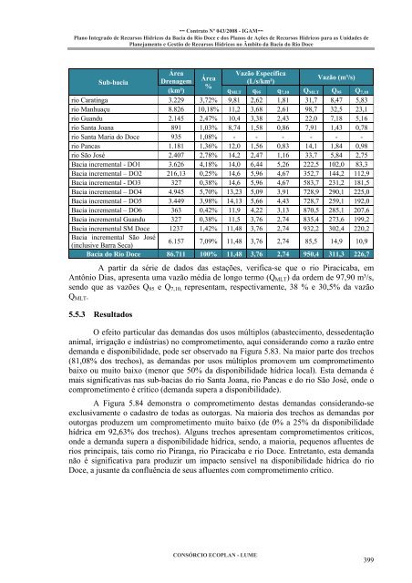
Sub-bacia<br />
Área<br />
Drenagem<br />
Área Vazão Específica<br />
Vazão (m³/s)<br />
(L/s/km²)<br />
%<br />
(km²) q MLT q 95 q 7,10 Q MLT Q 95 Q 7,10<br />
rio Caratinga 3.229 3,72% 9,81 2,62 1,81 31,7 8,47 5,83<br />
rio Manhuaçu 8.826 10,18% 11,2 3,68 2,61 98,7 32,5 23,1<br />
rio Guandu 2.145 2,47% 10,4 3,38 2,43 22,0 7,18 5,16<br />
rio Santa Joana 891 1,03% 8,74 1,58 0,86 7,91 1,43 0,78<br />
rio Santa Maria <strong>do</strong> <strong>Doce</strong> 935 1,08% - - - - - -<br />
rio Pancas 1.181 1,36% 12,0 1,56 0,83 14,1 1,84 0,98<br />
rio São José 2.407 2,78% 14,2 2,47 1,16 33,7 5,84 2,75<br />
<strong>Bacia</strong> incremental - DO1 3.626 4,18% 14,0 6,44 5,26 222,5 102,0 83,3<br />
<strong>Bacia</strong> incremental – DO2 216,13 0,25% 14,6 5,96 4,67 352,7 144,2 112,9<br />
<strong>Bacia</strong> incremental - DO3 327 0,38% 14,6 5,96 4,67 583,7 231,2 181,5<br />
<strong>Bacia</strong> incremental – DO4 4.945 5,70% 13,23 5,09 3,91 728,9 290,1 225,0<br />
<strong>Bacia</strong> incremental – DO5 3.449 3,98% 14,13 5,66 4,43 728,7 259,1 192,0<br />
<strong>Bacia</strong> incremental – DO6 363 0,42% 11,9 4,22 3,13 870,5 285,1 207,6<br />
<strong>Bacia</strong> incremental Guandu 327 0,38% 11,5 3,76 2,74 835,4 273,6 199,2<br />
<strong>Bacia</strong> incremental SM <strong>Doce</strong> 1237 1,42% 11,48 3,76 2,74 932,2 302,4 220,2<br />
<strong>Bacia</strong> incremental São José<br />
(inclusive Barra Seca)<br />
6.157 7,09% 11,48 3,76 2,74 85,5 14,9 10,9<br />
<strong>Bacia</strong> <strong>do</strong> <strong>Rio</strong> <strong>Doce</strong> 86.711 100% 11,48 3,76 2,74 950,4 311,3 226,7<br />
A partir <strong>da</strong> série <strong>de</strong> <strong>da</strong><strong>do</strong>s <strong>da</strong>s estações, verifica-se que o rio Piracicaba, em<br />
Antônio Dias, apresenta uma vazão média <strong>de</strong> longo termo (Q MLT ) <strong>da</strong> or<strong>de</strong>m <strong>de</strong> 97,90 m³/s,<br />
sen<strong>do</strong> que as vazões Q 95 e Q 7,10, representam, respectivamente, 38 % e 30,5% <strong>da</strong> vazão<br />
Q MLT .<br />
5.5.3 Resulta<strong>do</strong>s<br />
O efeito particular <strong>da</strong>s <strong>de</strong>man<strong>da</strong>s <strong>do</strong>s usos múltiplos (abastecimento, <strong>de</strong>sse<strong>de</strong>ntação<br />
animal, irrigação e indústrias) no comprometimento, aqui consi<strong>de</strong>ran<strong>do</strong> como a razão entre<br />
<strong>de</strong>man<strong>da</strong> e disponibili<strong>da</strong><strong>de</strong>, po<strong>de</strong> ser observa<strong>do</strong> na Figura 5.83. Na maior parte <strong>do</strong>s trechos<br />
(81,08% <strong>do</strong>s trechos), as <strong>de</strong>man<strong>da</strong>s por usos múltiplos promovem um comprometimento<br />
baixo ou muito baixo (menor que 50% <strong>da</strong> disponibili<strong>da</strong><strong>de</strong> hídrica local). Esta <strong>de</strong>man<strong>da</strong> é<br />
mais significativas nas sub-bacias <strong>do</strong> rio Santa Joana, rio Pancas e <strong>do</strong> rio São José, on<strong>de</strong> o<br />
comprometimento é crítico (<strong>de</strong>man<strong>da</strong> supera a disponibili<strong>da</strong><strong>de</strong>).<br />
A Figura 5.84 <strong>de</strong>monstra o comprometimento <strong>de</strong>stas <strong>de</strong>man<strong>da</strong>s consi<strong>de</strong>ran<strong>do</strong>-se<br />
exclusivamente o ca<strong>da</strong>stro <strong>de</strong> to<strong>da</strong>s as outorgas. Na maioria <strong>do</strong>s trechos as <strong>de</strong>man<strong>da</strong>s por<br />
outorgas produzem um comprometimento muito baixo (<strong>de</strong> 0% a 25% <strong>da</strong> disponibili<strong>da</strong><strong>de</strong><br />
hídrica em 92,63% <strong>do</strong>s trechos). Alguns trechos apresentam comprometimentos críticos,<br />
on<strong>de</strong> a <strong>de</strong>man<strong>da</strong> supera a disponibili<strong>da</strong><strong>de</strong> hídrica, sen<strong>do</strong>, a maioria, pequenos afluentes <strong>de</strong><br />
rios principais, tais como rio Piranga, rio Piracicaba e rio <strong>Doce</strong>. Entretanto, esta <strong>de</strong>man<strong>da</strong><br />
não é significativa para produzir um impacto sensível na disponibili<strong>da</strong><strong>de</strong> hídrica <strong>do</strong> rio<br />
<strong>Doce</strong>, a jusante <strong>da</strong> confluência <strong>de</strong> seus afluentes com comprometimento crítico.<br />
CONSÓRCIO ECOPLAN - LUME<br />
399