
Create successful ePaper yourself
Turn your PDF publications into a flip-book with our unique Google optimized e-Paper software.
Durão<br />
Revista de Gestão Costeira Integrada / Journal of Integrated Coastal Zone Management 12(1):17-30 (2012)<br />
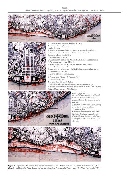
1. Limite oriental, Tercenas da Porta da Cruz.<br />
2. Limite ocidental, Santos.<br />
Esteiro da Baixa<br />
A. Aterro no esteiro da Baixa iniciou-se à cerca de dois milénios.<br />
B. Aterro na frente do esteiro, sobre a praia no séc. XIV.<br />
C. Aterro sobre o rio, séc. XX.<br />
Frente ribeirinha oriental<br />
D. Aterros sobre a praia, séc. XIV-XVIII. Realizados gradualmente.<br />
E. Aterros sobre o rio, séc. XIX-XX.<br />
F. Aterro sobre o rio, séc. XX de Sta. Apolónia para Chelas.<br />
Frente ribeirinha ocidental<br />
G. Aterros sobre a praia, séc. XIV-XVIII. Realizados gradualmente.<br />
H. Aterros sobre o rio, séc. XIX<br />
I. Aterros sobre o rio, séc. XIX-XX.<br />
1. Eastern limit, Tercenas da Porta da Cruz.<br />
2. Western limit, Santos.<br />
Downton Creek (Esteiro da Baixa)<br />
A. Landfill in downtown creek started about two millennia ago.<br />
B. Landfill in the front of the creek, above the beach, in the 14th Century.<br />
C. Landfill over the river, 20 th Century<br />
Eastern riverfront<br />
D. Landfills over the beach, 14th-18th<br />
Centuries. Constructed by degrees.<br />
E. Landfills over the river, 19 th -20 th<br />
Centuries.<br />
F. Landfills over the river, 20th Century.<br />
From Sta. Apolónia to Chelas.<br />
Western riverfront<br />
G Landfills over the beach, 14th-18th<br />
Centuries. Realizados gradualmente.<br />
H.Landfills over the river, 19th Century<br />
I. Landfills over the river, 19 th -20 th<br />
Centuries.<br />
Figura 2. Mapeamento dos aterros. Baixa e frente ribeirinha de Lisboa. Extrato da Carta Topográfica de Lisboa de 1911, CML.<br />
Figure 2. Landfill Mapping. Lisbon downton and riverfront. Extract from the topographical chart of Lisbon, 1911, Lisbon City Council (CML).<br />
- 21 -