NOAA Celebrating 200 Years of Science, Service, and Stewardship
NOAA Celebrating 200 Years of Science, Service, and Stewardship
NOAA Celebrating 200 Years of Science, Service, and Stewardship

Create successful ePaper yourself
Turn your PDF publications into a flip-book with our unique Google optimized e-Paper software.
<strong>NOAA</strong><br />
elebrating <strong>200</strong> <strong>Years</strong> o cience,<br />
ervice, <strong>and</strong> tewardshi<br />
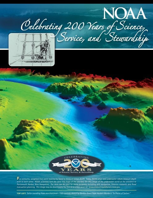
For centuries, weighted lines were lowered by h<strong>and</strong> to measure ocean depth. Today, <strong>NOAA</strong> ships <strong>and</strong> underwater robots measure depth<br />
with hi-tech sonar. <strong>NOAA</strong> scientists turn the data into maps <strong>of</strong> the sea bed, like this image <strong>of</strong> the underwater world at the entrance to<br />
Portsmouth Harbor, New Hampshire. The data can be used for many purposes, including safe navigation, fisheries research, <strong>and</strong> flood<br />
evacuation planning. This image may be downloaded for free as a screen saver at: www.celebrating<strong>200</strong>years.noaa.gov<br />
TOP LEFT: Sailor sounding from merchantman—19th century, sketch by Gordon Grant from Herbert Warden’s “In Praise <strong>of</strong> Sailors.”
Celebrate!<br />
You’re invited to help<br />
us celebrate <strong>200</strong> years<br />
<strong>of</strong> science, service <strong>and</strong><br />
stewardship to the nation.<br />
We’re the men <strong>and</strong> women <strong>of</strong><br />
<strong>NOAA</strong>, the National Oceanic<br />
<strong>and</strong> Atmospheric Administration,<br />
the federal agency<br />
charged with underst<strong>and</strong>ing<br />
These amazing lightning images were<br />
taken during the STEPS Project. STEPS<br />
<strong>and</strong> predicting changes in<br />
st<strong>and</strong>s for Severe Thunderstorm Electrification<br />
<strong>and</strong> Precipitation Study. This managing America’s ocean<br />
the Earth’s environment, <strong>and</strong><br />
project studied supercells on the high<br />
resources. Starting with<br />
plains <strong>of</strong> Colorado <strong>and</strong> Kansas. May 25,<br />
<strong>200</strong>0. Credit: National Weather <strong>Service</strong> Forecast Thomas Jefferson’s establishment<br />
<strong>of</strong> the Coast Survey in<br />
Office Goodl<strong>and</strong>, Kansas.<br />
1807, much <strong>of</strong> this country’s<br />
scientific heritage is rooted in <strong>NOAA</strong>, part <strong>of</strong> the Department<br />
<strong>of</strong> Commerce. <strong>NOAA</strong> plays a vital role in the life <strong>of</strong> every<br />
American, from weather forecasts, fisheries management,<br />
safe navigation, <strong>and</strong> coastal surveying to remote sensing,<br />
climate research, <strong>and</strong> ocean exploration.<br />
We carry out our work within several <strong>NOAA</strong> organizations.<br />
The Coast Survey became the U.S. Coast <strong>and</strong> Geodetic<br />
Survey <strong>and</strong> is today part <strong>of</strong> National Ocean <strong>Service</strong>.<br />
America’s 19th–century weather observation networks<br />
coalesced first into a service in the U.S. Army Signal Corps,<br />
<strong>and</strong> in 1891, into the civilian Weather Bureau—today’s<br />
National Weather <strong>Service</strong>. The National Marine Fisheries<br />
<strong>Service</strong> grew from the U.S. Fish <strong>and</strong> Fisheries Commission,<br />
established in 1871. And the creation <strong>of</strong> <strong>NOAA</strong> in<br />
1970 also incorporated the Environmental<br />
Data <strong>Service</strong>, National Oceanographic<br />
Data Center, National Sea Grant<br />
programs, <strong>and</strong> other activities<br />
into the Office <strong>of</strong> Oceanic<br />
<strong>and</strong> Atmospheric Research.<br />
NASA’s weather satellite system is now part <strong>of</strong> <strong>NOAA</strong>’s<br />
National Environmental Satellite, Data, <strong>and</strong> Information<br />
<strong>Service</strong>. And our service is growing as <strong>NOAA</strong> works with<br />
many federal partners <strong>and</strong> more than 60 countries on the<br />
Global Earth Observation System, a vast network to monitor<br />
<strong>and</strong> predict Earth’s changes.<br />
We hope you’ll share our pride in <strong>NOAA</strong>. Our agency plays<br />
a pivotal role in the U.S. economy, providing products <strong>and</strong><br />
services that affect 30 percent <strong>of</strong> the nation’s gross domestic<br />
product every year. The waterborne cargo relying on <strong>NOAA</strong><br />
for safe navigation contributes<br />
over $1 trillion annually<br />
in revenues; the fishing<br />
industry adds another $30<br />
billion each year to America’s<br />
economy, <strong>and</strong> ocean research<br />
creates billions in new products<br />
<strong>and</strong> discoveries. As for<br />
our weather <strong>and</strong> climate<br />
services, the value <strong>of</strong> lives<br />
<strong>and</strong> property saved through<br />
<strong>NOAA</strong>’s timely forecasts <strong>and</strong><br />
warnings is beyond calculation.<br />
We at <strong>NOAA</strong> take pride<br />
in our job: providing vital<br />
support to domestic security<br />
<strong>and</strong> global competitiveness,<br />
<strong>and</strong> enhancing the quality <strong>of</strong><br />
life for our fellow citizens.<br />
By the 1980’s NMFS gear specialists had<br />
developed a cost-effective Turtle Excluder<br />
Device (TED) for trawl nets. Credit: <strong>NOAA</strong><br />
Fisheries <strong>Service</strong>.<br />
Pillar coral, Florida Keys National Marine<br />
Sanctuary. Credit: William Harrigan<br />
No single document can tell the whole story <strong>of</strong> the dedicated people,<br />
historic events <strong>and</strong> scientific breakthroughs that have shaped <strong>NOAA</strong>. This<br />
brochure highlights some <strong>of</strong> this rich history. For more about our foundation<br />
organizations, their current roles <strong>and</strong> activities, <strong>and</strong> how <strong>NOAA</strong> affects your<br />
life in positive ways, visit www.celebrating<strong>200</strong>years.noaa.gov.<br />
LEFT PHOTO: <strong>NOAA</strong> hydrographic survey launch <strong>of</strong>f the RANIER in front <strong>of</strong> Sawyer Glacier, Alaska. Credit: <strong>NOAA</strong>.
Surveys <strong>and</strong> Commerc<br />
Our <strong>200</strong> years <strong>of</strong> history<br />
begins in 1807<br />
when President Thomas<br />
Jefferson signed an Act “to provide<br />
for surveying the coasts <strong>of</strong> the<br />
United States.” The fledgling<br />
nation’s success depended on<br />
efficient maritime commerce <strong>and</strong><br />
border defense, <strong>and</strong> the tools to<br />
succeed were accurate charts <strong>of</strong><br />
shores, waters <strong>and</strong> hazards to<br />
safe navigation. Thus was born<br />
America’s first science agency — the<br />
Coast Survey — <strong>and</strong> a tradition <strong>of</strong> perseverance, scientific<br />
integrity, skill bordering on art, <strong>and</strong> the courage dem<strong>and</strong>ed<br />
<strong>of</strong> explorers charting the unknown. Later renamed the U.S.<br />
Coast <strong>and</strong> Geodetic Survey, this agency was among the first<br />
incorporated into today’s <strong>NOAA</strong>.<br />
Today, waterborne<br />
commerce remains<br />
the backbone <strong>of</strong> the<br />
U.S. economy, contributing<br />
over 13<br />
million jobs <strong>and</strong> $1<br />
trillion annually. The<br />
marine transportation<br />
system moves over<br />
Tug boat moving container ship loaded with goods<br />
95 percent <strong>of</strong> U.S.<br />
for U.S. markets, Chesapeake <strong>and</strong> Delaware Canal.<br />
Credit: <strong>NOAA</strong>.<br />
foreign trade tonnage<br />
each year, along with<br />
two thirds <strong>of</strong> everything Americans buy, eat <strong>and</strong> wear.<br />
Commercial shipping, fisheries, recreational boating, tourism,<br />
national defense, emergency responders, <strong>and</strong> coastal<br />
management rely on <strong>NOAA</strong>’s nautical charts, tides <strong>and</strong><br />
currents data, <strong>and</strong> an accurate geodetic positioning<br />
framework.<br />
Though the methods have changed over time, <strong>NOAA</strong>’s<br />
navigation services continue to benefit safety, national<br />
Coast <strong>and</strong> Geodetic Survey crew uses a<br />
plane table to map shoreline in Southeast<br />
Alaska circa 1921. Credit: <strong>NOAA</strong>.<br />
security <strong>and</strong> economic competitiveness.<br />
The nation’s ports,<br />
harbors, <strong>and</strong> waterways are<br />
highways for commerce, resources<br />
for recreation, <strong>and</strong> places <strong>of</strong> scenic<br />
beauty. Reducing risk <strong>of</strong> accident<br />
boosts the U.S. economy by<br />
preventing the consequences <strong>of</strong> a<br />
grounding or oil spill—response <strong>and</strong><br />
recovery costs, delays to other vessels<br />
<strong>and</strong> cargo, port shutdowns, <strong>and</strong><br />
damage to the environment. Debris<br />
left in Gulf waters after the <strong>200</strong>5<br />
hurricanes is a stark reminder <strong>of</strong> the changing hazards facing<br />
mariners navigating between U.S. ports, <strong>and</strong> the importance<br />
<strong>of</strong> accurate <strong>NOAA</strong> hydrographic surveys, nautical charts <strong>and</strong><br />
real-time water level <strong>and</strong> positioning data. As ships grow<br />
in size <strong>and</strong> number, <strong>and</strong> waterway congestion increases,<br />
<strong>NOAA</strong>’s information about the uncertain environment in<br />
which mariners must operate becomes ever more critical.<br />
Where <strong>200</strong> years ago sailors tossed leadlines overboard<br />
to measure water depth, <strong>and</strong> location was determined by<br />
observing the stars, <strong>NOAA</strong> now uses multibeam <strong>and</strong> side<br />
scan sonar technology to fully map the sea bottom, Global<br />
Positioning System satellites for centimeter-accuracy<br />
positioning, tide stations that report water levels every<br />
six minutes, <strong>and</strong> advanced computers for compiling data<br />
into electronic nautical charts <strong>and</strong> other useful products.<br />
The Coast <strong>and</strong> Geodetic Survey’s pursuit <strong>of</strong> excellence in<br />
charting the nation’s shoreline <strong>and</strong> waters for safe <strong>and</strong><br />
efficient marine<br />
t r a n s p o r t a t i o n<br />
is testimony to<br />
Thomas Jefferson’s<br />
foresight <strong>and</strong> a<br />
reminder <strong>of</strong> how<br />
vital maritime commerce<br />
is to the<br />
United States.<br />
<strong>NOAA</strong> Hydrographic Survey vessel RAINIER<br />
<strong>of</strong>floading a launch in preparation to survey, Auke<br />
Bay, Southeast Alaska. Credit: <strong>NOAA</strong>.
Weather <strong>and</strong> Climat<br />
At the time <strong>of</strong> the first federal<br />
coastal surveys in 1807,<br />
Americans were already<br />
careful observers <strong>of</strong> country’s<br />
climate <strong>and</strong> weather patterns. For<br />
example, George Washington <strong>and</strong><br />
Thomas Jefferson recorded the daily<br />
weather. Telegraph operations in<br />
1845 made it possible to transmit<br />
weather data, leading to President<br />
Grant’s authorization <strong>of</strong> a national<br />
weather agency under the Army<br />
Signal <strong>Service</strong>. Today’s National<br />
Weather <strong>Service</strong> is the largest single<br />
component <strong>of</strong> <strong>NOAA</strong>, providing<br />
weather, hydrologic, <strong>and</strong> climate<br />
forecasts <strong>and</strong> warnings for the United States, its territories,<br />
<strong>and</strong> adjacent ocean waters that protect life, property, <strong>and</strong><br />
the nation’s economy.<br />
Operations area, National Weather <strong>Service</strong><br />
Forecast Office in Key West, Florida as spiral<br />
b<strong>and</strong>s from Hurricane Charley spread over the<br />
Florida Keys. August 13, <strong>200</strong>4. Credit: Jim W. Lee.<br />
The Weather <strong>Service</strong> is<br />
the <strong>of</strong>ficial U.S. voice<br />
for watches <strong>and</strong> warnings<br />
during lifethreatening<br />
weather<br />
conditions. From 122<br />
weather forecast<br />
<strong>of</strong>fices, 13 river forecast<br />
centers, nine<br />
national centers, <strong>and</strong><br />
other support <strong>of</strong>fices,<br />
4,700 employees gather<br />
<strong>and</strong> analyze global<br />
data from l<strong>and</strong>, sea,<br />
<strong>and</strong> atmospheric sources. The <strong>Service</strong> uses an array <strong>of</strong><br />
satellites operated by <strong>NOAA</strong>’s National Environmental<br />
Satellite, Data, <strong>and</strong> Information <strong>Service</strong>, including the powerful<br />
Geostationary Operational Environmental Satellites that<br />
orbit 22,300 miles above the Earth. <strong>NOAA</strong>’s network <strong>of</strong><br />
140 high-powered Doppler radars blanket America <strong>and</strong> its<br />
territories, providing meteorologists with the lead time for<br />
warnings to save lives <strong>and</strong> minimize property loss. Information<br />
is also gathered from marine data buoys, surface observing<br />
systems, <strong>and</strong> instruments that monitor space weather<br />
At a cooperative weather station in<br />
Granger, Utah, a volunteer observes<br />
temperature, precipitation, sky conditions,<br />
etc. Circa 1930. Credit: <strong>NOAA</strong>.<br />
<strong>and</strong> air quality. Complex models <strong>and</strong><br />
high-speed communications systems<br />
compile this data for timely dissemination<br />
to the public.<br />
<strong>NOAA</strong> Research in technologies<br />
such as phased array radar, dual<br />
polar radar, <strong>and</strong> unmanned aircraft<br />
systems will provide forecasters with<br />
better views <strong>of</strong> existing conditions,<br />
while further development <strong>of</strong><br />
numerical prediction models will<br />
increase accuracy <strong>of</strong> weather <strong>and</strong> air<br />
quality forecasts.<br />
<strong>NOAA</strong> also studies <strong>and</strong> predicts<br />
changes from climate patterns. Weather changes can occur<br />
quickly, but climate varies from year to year, decade to decade,<br />
<strong>and</strong> even across centuries. Changes in the atmosphere,<br />
oceans, ice sheets, l<strong>and</strong>, <strong>and</strong> life forms are studied. The<br />
Climate Program Office coordinates climate research across<br />
<strong>NOAA</strong> <strong>and</strong> its partner organizations providing reliable <strong>and</strong><br />
accurate information on the Earth’s changing climate.<br />
The National Weather <strong>Service</strong> is achieving its vision <strong>of</strong> providing<br />
the world’s best weather <strong>and</strong> climate information by delivering<br />
consistently reliable <strong>and</strong> accurate forecasts that greatly reduce<br />
weather <strong>and</strong> water-related injuries <strong>and</strong> fatalities. <strong>NOAA</strong><br />
Weather Radio All Hazards is a nationwide network <strong>of</strong> more<br />
than 950 radio stations broadcasting continuous weather<br />
information directly from local NWS <strong>of</strong>fices. <strong>NOAA</strong> Weather<br />
Radio also broadcasts warning <strong>and</strong> post-event information<br />
for other hazards,<br />
including earthquakes,<br />
avalanches, environmental<br />
accidents,<br />
AMBER alerts <strong>and</strong> 911<br />
telephone outages.<br />
Information from the<br />
National Weather<br />
<strong>Service</strong> touches our<br />
lives every day.<br />
GOES-12 satellite imagery <strong>of</strong> Hurricane Katrina<br />
over the Gulf <strong>of</strong> Mexixo at peak intensity <strong>of</strong> 175<br />
mph. August 28, <strong>200</strong>5. Credit: <strong>NOAA</strong>.
Living Marine Rsource<br />
The U.S. Commission <strong>of</strong><br />
Fish <strong>and</strong> Fisheries became,<br />
in 1871, America’s first<br />
federal conservation agency. But<br />
U.S. involvement lay deeper, in<br />
the 1783 Treaty <strong>of</strong> Paris <strong>and</strong> 1822<br />
Treaty <strong>of</strong> Ghent that granted fishing<br />
rights to U.S. fishermen, <strong>and</strong> in the<br />
writings <strong>of</strong> Thomas Jefferson <strong>and</strong><br />
others about the federal interest<br />
in fisheries. Since its founding, the<br />
Commission’s name changed to the<br />
Bureau <strong>of</strong> Fisheries, then the Bureau<br />
<strong>of</strong> Commercial Fisheries, <strong>and</strong> finally,<br />
in 1971, the National Marine Fisheries <strong>Service</strong>—also called<br />
<strong>NOAA</strong> Fisheries <strong>Service</strong>. Other <strong>NOAA</strong> organizations—the<br />
National Ocean <strong>Service</strong>, <strong>and</strong> Oceanic <strong>and</strong> Atmospheric<br />
Research—also provide important research <strong>and</strong> public<br />
education on America’s living marine resources.<br />
These three <strong>NOAA</strong> organizations work cooperatively to ensure<br />
healthy <strong>and</strong> productive coastal <strong>and</strong> marine ecosystems. The<br />
<strong>NOAA</strong> Fisheries <strong>Service</strong> Ecosystem Observations Program<br />
collects, manages <strong>and</strong> disseminates data on the status <strong>of</strong><br />
living marine resources to provide managers with information<br />
for informed decisions; the agency’s effectiveness can<br />
be traced to a long history <strong>of</strong> alliances with the Regional<br />
Fishery Management Councils; Interstate Marine Fisheries<br />
Commissions; other federal, state, <strong>and</strong> tribal governments;<br />
industry; academia; <strong>and</strong> non-governmental organizations.<br />
<strong>NOAA</strong> Fisheries <strong>and</strong> the National Ocean <strong>Service</strong> work jointly<br />
to protect <strong>and</strong> restore habitat <strong>and</strong> coral reefs.<br />
Salmon conservation is a top priority <strong>of</strong> the<br />
Fisheries <strong>Service</strong>. Credit: <strong>NOAA</strong> Fisheries <strong>Service</strong>.<br />
19th century fishermen bail menhaden from<br />
a purse seine into a steamer’s hold. From<br />
a sketch by J.S. Ryder in “The Fisheries<br />
<strong>and</strong> Fishery Industries <strong>of</strong> the United States,<br />
1887. Credit: <strong>NOAA</strong> Library.<br />
The Ocean <strong>Service</strong> is<br />
also responsible for<br />
the 13 National Marine<br />
Sanctuaries, National<br />
Estuarine Research Reserves,<br />
<strong>and</strong> National<br />
Hazards Assessment.<br />
Both agencies also<br />
collaborate with <strong>NOAA</strong>’s<br />
Oceanic <strong>and</strong> Atmospheric<br />
Research (which manages<br />
the National Sea Grant Program,<br />
Undersea Research Program, <strong>and</strong><br />
Joint Research Institutes) to study<br />
the effects <strong>of</strong> climate on marine<br />
ecosystems.<br />
Major conservation laws guiding<br />
<strong>NOAA</strong> are the Magnuson-<br />
Stevens Fishery Conservation <strong>and</strong><br />
Management Act, Marine Mammal<br />
Protection Act, Endangered Species<br />
Act, <strong>and</strong> National Environmental<br />
Protection Act. Such complex m<strong>and</strong>ates<br />
require a broad array <strong>of</strong> activities: information on<br />
fishery stocks (<strong>and</strong> protected resources that are sometimes<br />
taken by fishermen); development <strong>of</strong> fishery management <strong>and</strong><br />
enforcement measures; coastal fishery habitat protection;<br />
<strong>and</strong> development <strong>of</strong> marine aquaculture. The work results in a<br />
massive amount <strong>of</strong> resource survey data;<br />
plans <strong>and</strong> regulations for more than <strong>200</strong><br />
fishery stocks <strong>and</strong> almost as many stocks<br />
<strong>of</strong> marine mammals <strong>and</strong> sea turtles;<br />
fishery licenses <strong>and</strong> permits; shipboard<br />
observer data; consultations for protected<br />
resources <strong>and</strong> coastal habitats;<br />
enforcement patrols <strong>and</strong> investigations;<br />
habitat restoration; conservation fishing<br />
gear development; seafood safety<br />
research <strong>and</strong> monitoring; <strong>and</strong> public<br />
education <strong>and</strong> outreach. The outcome?<br />
Coastal economies strengthened as<br />
stringent new regulations help recover<br />
depleted fish stocks <strong>and</strong> reduce bycatch.<br />
Increased recreational opportunities<br />
for millions <strong>of</strong> anglers <strong>and</strong> boaters.<br />
Thous<strong>and</strong>s <strong>of</strong> habitat acres conserved<br />
or restored. A host <strong>of</strong> marine mammals<br />
A <strong>NOAA</strong> Fisheries <strong>Service</strong><br />
Enforcement <strong>of</strong>ficer helps<br />
Gulf <strong>of</strong> Mexico fishermen<br />
underst<strong>and</strong> fisheries laws.<br />
Credit: William B. Folsom, <strong>NOAA</strong><br />
Fisheries <strong>Service</strong>.<br />
<strong>and</strong> other protected resources that are beginning to flourish.<br />
And, each year, more coastal communities that incorporate<br />
ecosystem <strong>and</strong> sustainable development principles into their<br />
planning <strong>and</strong> management.
Ocean <strong>and</strong> Cost<br />
The ocean was the focus<br />
<strong>of</strong> <strong>NOAA</strong>’s oldest ancestor<br />
agency, <strong>and</strong> a need to better<br />
underst<strong>and</strong> the ocean was a force in<br />
forming the Weather Bureau <strong>and</strong> the<br />
Bureau <strong>of</strong> Commercial Fisheries. But<br />
there are other ways in which <strong>NOAA</strong><br />
<strong>and</strong> its predecessors have strong<br />
connections to the ocean, coasts,<br />
Great Lakes, <strong>and</strong> their resources.<br />
A plate documenting some <strong>of</strong> the oldest<br />
studies <strong>of</strong> Florida Reefs. Credit: “Report on<br />
the Florida Reefs,” 1880 by Louis Agassiz.<br />
<strong>NOAA</strong> protects, preserves, manages,<br />
restores <strong>and</strong> enhances the<br />
nation’s coastal resources <strong>and</strong> ecosystems along 95,000<br />
miles <strong>of</strong> shoreline <strong>and</strong> 3.5 million square miles <strong>of</strong> coastal<br />
ocean. <strong>NOAA</strong> manages 13 national marine sanctuaries, the<br />
ocean equivalent <strong>of</strong> national parks, <strong>and</strong> the immense Northwestern<br />
Hawaiian Isl<strong>and</strong> area recently became a National<br />
Monument, extending<br />
<strong>NOAA</strong>’s responsibility<br />
for ocean oversight<br />
<strong>and</strong> stewardship. <strong>NOAA</strong><br />
<strong>and</strong> partners study <strong>and</strong><br />
conserve coral reefs,<br />
<strong>and</strong> develop <strong>and</strong> deploy<br />
technology to explore<br />
<strong>and</strong> map in all its<br />
A black-necked stilt hunting for its dinner. Credit: dimensions, the largely<br />
<strong>NOAA</strong> National Estuarine Research Reserve Collection.<br />
unknown deep ocean.<br />
Ocean exploration, research <strong>and</strong> programs support<br />
fisheries, discover submerged historic <strong>and</strong> cultural<br />
resources, build the economy through support<br />
for businesses such as biotechnology, <strong>and</strong> reduce<br />
impacts <strong>of</strong> aquatic invasive species. <strong>NOAA</strong> conducts research<br />
in 26 national estuarine research reserves, studies how<br />
human activities relate to coastal ecosystems, investigates<br />
the effects <strong>of</strong> pollutants on the marine environment <strong>and</strong><br />
remediates oil <strong>and</strong> chemical spills. The National Sea Grant<br />
College Program engages 30 top universities <strong>and</strong> institutions<br />
in scientific research to better underst<strong>and</strong> ocean,<br />
coastal, <strong>and</strong> Great Lakes resources. Supporting ocean<br />
missions are <strong>NOAA</strong> satellites,<br />
divers, <strong>and</strong> the ships <strong>and</strong> Commissioned<br />
Officer’s Corps in <strong>NOAA</strong>’s<br />
Office <strong>of</strong> Marine <strong>and</strong> Aviation<br />
Operations.<br />
In addition to sustaining fish stocks<br />
<strong>and</strong> charting for safe navigation<br />
<strong>and</strong> commerce, <strong>NOAA</strong>’s oceanrelated<br />
work has discovered marine<br />
animals with chemical compounds<br />
that promise new medicines, <strong>and</strong><br />
mapping <strong>of</strong> the ocean floor will<br />
support possible future expansion <strong>of</strong> the U.S. Exclusive<br />
Economic Zone (EEZ) where potential resources valued at<br />
$1.3 trillion are estimated to exist. Because most hurricanerelated<br />
deaths are flood related, <strong>NOAA</strong> developed an important<br />
new tool to help emergency managers predict <strong>and</strong><br />
track flood waters. <strong>NOAA</strong> research <strong>and</strong> programs counter<br />
Harmful Algal Blooms that cost the economy $75 million<br />
annually, <strong>and</strong> the agency has recovered compensation for<br />
restoration at hazardous waste sites <strong>and</strong> coastal <strong>and</strong> marine<br />
resources injured from chemical releases <strong>and</strong> oil spills. <strong>NOAA</strong><br />
researches how El Niño <strong>and</strong> other ocean-related changes<br />
affect climate, <strong>and</strong> an increasing number <strong>of</strong> ocean buoys<br />
record ocean data <strong>and</strong> changes for emergency response or<br />
for research. The agency certifies open <strong>and</strong> closed-circuit<br />
diving technologies for science applications, <strong>and</strong> <strong>NOAA</strong>’s<br />
Aquarius, the world’s only underwater laboratory, supports<br />
ocean science <strong>and</strong> the training <strong>of</strong> NASA astronauts. Ships,<br />
satellites, buoys, <strong>and</strong><br />
other ocean sensors<br />
<strong>and</strong> systems support<br />
the Integrated Ocean<br />
Observing System,<br />
part <strong>of</strong> a larger system<br />
taking the pulse<br />
<strong>of</strong> our ocean planet.<br />
The Institute for Exploration’s undersea robot<br />
Hercules approaches a ghostly, white, carbonate<br />
spire in the Lost City hydrothermal<br />
field, 2,500 feet deep in the Atlantic Ocean.<br />
Credit: IFE, URI-IAO, UW, Lost City science party, <strong>and</strong> <strong>NOAA</strong>.