engineering
35_attachement_catalogue
35_attachement_catalogue

Create successful ePaper yourself
Turn your PDF publications into a flip-book with our unique Google optimized e-Paper software.
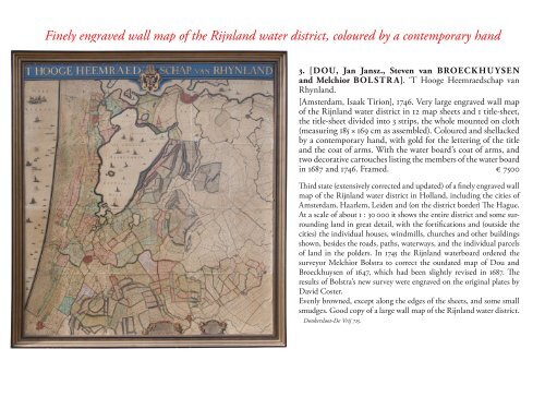
Finely engraved wall map of the Rijnland water district, coloured by a contemporary hand<br />
3. [DOU, Jan Jansz., Steven van BROECK HU YSEN<br />
and Melchior BOL STR A]. ‘T Hooge Heemraedschap van<br />
Rhynland.<br />
[Amsterdam, Isaak Tirion], 1746. Very large engraved wall map<br />
of the Rijnland water district in 12 map sheets and 1 title-sheet,<br />
the title-sheet divided into 3 strips, the whole mounted on cloth<br />
(measuring 185 × 169 cm as assembled). Coloured and shellacked<br />
by a contemporary hand, with gold for the lettering of the title<br />
and the coat of arms. With the water board’s coat of arms, and<br />
two decorative cartouches listing the members of the water board<br />
in 1687 and 1746. Framed. € 7500<br />
Third state (extensively corrected and updated) of a finely engraved wall<br />
map of the Rijnland water district in Holland, including the cities of<br />
Amsterdam, Haarlem, Leiden and (on the district border) The Hague.<br />
At a scale of about 1 : 30 000 it shows the entire district and some surrounding<br />
land in great detail, with the fortifications and (outside the<br />
cities) the individual houses, windmills, churches and other buildings<br />
shown, besides the roads, paths, waterways, and the individual parcels<br />
of land in the polders. In 1745 the Rijnland waterboard ordered the<br />
surveyor Melchior Bolstra to correct the outdated map of Dou and<br />
Broeckhuysen of 1647, which had been slightly revised in 1687. The<br />
results of Bolstra’s new survey were engraved on the original plates by<br />
David Coster.<br />
Evenly browned, except along the edges of the sheets, and some small<br />
smudges. Good copy of a large wall map of the Rijnland water district.<br />
Donkersloot-De Vrij 715.