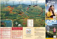
Wanderfolder - Zillertal Arena
Wanderfolder - Zillertal Arena
Wanderfolder - Zillertal Arena

Erfolgreiche ePaper selbst erstellen
Machen Sie aus Ihren PDF Publikationen ein blätterbares Flipbook mit unserer einzigartigen Google optimierten e-Paper Software.
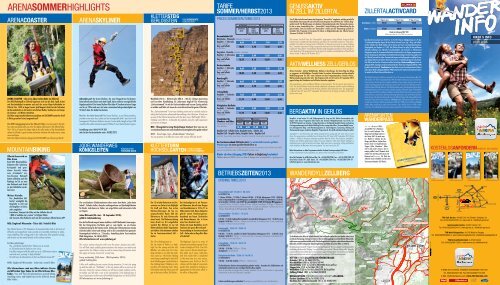
ARENASOMMERHIGHLIGHTS<br />
ARENACOASTER ARENASKYLInER<br />
ARENA COASTER - die erste Alpen-Achterbahn im <strong>Zillertal</strong><br />
Der NEUE Rodelspaß im <strong>Zillertal</strong> begeistert nicht nur die Kids: Spaß, Action<br />
und Geschwindigkeit erwarten euch auf der ersten Alpen-Achterbahn im<br />
<strong>Zillertal</strong>. Der 1.450 m lange Coaster-Spaß beginnt direkt bei der Talstation<br />
der Rosenalmbahn in Zell und ist mit etlichen Wellen, Steilkurven und Jumps<br />
die Sommer- und Winter-Attraktion.<br />
Und beim angrenzenden Abenteuerspielplatz mit BAGJUMP kommt bei Groß<br />
& Klein garantiert keine Langeweile auf!<br />
The NEW tobogganing fun in the <strong>Zillertal</strong> Valley is not just great for the kids:<br />
fun, action and speed await you at the first Alpine rollercoaster in the <strong>Zillertal</strong> Valley.<br />
The 1,450 m of coaster fun begins right at the valley station of the Rosenalmbahn<br />
railway in Zell and is a great summer and winter attraction with endless waves, steep<br />
curves and jumps.<br />
And at the adjacent adventure playground with BAGJUMP you will never get bored!<br />
MOuNTAINBIKInG<br />
<strong>Zillertal</strong> <strong>Arena</strong> wird zur<br />
Bike <strong>Arena</strong><br />
Rund 325 Mountainbikekilometer<br />
aller Schwierigkeitsgrade<br />
und grandioser<br />
Aussicht laden<br />
zum „Strampeln“ ein.<br />
Geruhsamen Radspaß<br />
bieten außerdem auch die<br />
Radwege im Tal, wo man<br />
den Drahtesel auch direkt<br />
an den Bahnhöfen ausleihen<br />
kann.<br />
Weitere Vorteile:<br />
Das „Kombiticket Zell<br />
Gerlos“ ermöglicht die<br />
Bergfahrt in Zell und<br />
die Bergfahrt in Gerlos<br />
oder umgekehrt.<br />
kostenloser Transport der Bikes mit der Seilbahn bis auf<br />
1.800 m Seehöhe und „cruisen“ in luftigen Höhen<br />
alle Touren & Infos finden Sie auch auf der kostenlosen <strong>Zillertal</strong> <strong>Arena</strong> APP<br />
NEU: Singletrail Wiesenalm · Ticket inkl. Verleih E-Bike<br />
The <strong>Zillertal</strong> <strong>Arena</strong>‘s 325 kilometres of mountainbike trails at all levels of<br />
difficulty and magnificent views provide an irresistible invitation to enthusiastic<br />
pedalling. The cycling paths in the valley also offer peaceful cycling,<br />
and bicycles can be rented directly at the railway stations.<br />
Further advantage:<br />
The „ZellGerlos Combi Ticket“ allows you to ascend<br />
to Zell and ascend to Gerlos or vice versa.<br />
free bike transport with the cable car up to 1,800 meters above<br />
sea level and „cruising“ in high altitudes“<br />
find all tours & informations at the free <strong>Zillertal</strong> <strong>Arena</strong> APP<br />
NEW: Singletrail Wiesenalm · ticket incl. rental E-bike<br />
Alle Informationen rund ums Biken inklusive Routen<br />
und hilfreichen Tipps finden Sie im <strong>Zillertal</strong> <strong>Arena</strong> Bike-<br />
Folder. You will find all informations around biking<br />
including routes and helpful tips in the <strong>Zillertal</strong> <strong>Arena</strong><br />
Bike Folder.<br />
Adrenalin pur! Der <strong>Arena</strong> Skyliner, das neue Fluggerät am Gerlosstein,<br />
bietet allen <strong>Arena</strong>-Gästen noch mehr Spaß, Action und eine unvergleichliche<br />
Vogelperspektive! Der <strong>Arena</strong> Skyliner führt über 4 Strecken mit einer Länge<br />
von bis zu 738 m und saust mit einer maximalen Fahrgeschwindigkeit von<br />
50 km/h über das Gebiet Gerlosstein.<br />
Not for the faint hearted! The <strong>Arena</strong> Skyliner, a new flying machine,<br />
provides even more fun, action and an incomparable bird’s-eye view to all<br />
<strong>Arena</strong> guests! The <strong>Arena</strong> Skyliner runs on 4 routes with a length of up to 738<br />
m and hurtles with a maximum speed of 50 km/h over the Gerlosstein region.<br />
Anmeldung unter: 0664/44 19 283<br />
oder bei der Gerlossteinbahn unter: 05282/2275<br />
JODELWANDERWEG<br />
KÖnIGSLEITEn<br />
KöNIGSLEITEN<br />
YOdELInG WALK<br />
Die verschiedenen Erlebnisstationen stehen unter dem Motto „Jeder kann<br />
Jodeln“. Einfache Jodler, die jeder nachsingen kann und Spielmöglichkeiten<br />
für Kinder sind ebenso zu finden, wie urige Hütten und interessante Infos<br />
zur Region.<br />
Jeden Mittwoch (26. Juni - 18. September 2013):<br />
geführte Jodelwanderung<br />
Eine leichte Wanderung mit einem Jodelkurs schafft bleibende Erinnerungen.<br />
Mit der Königsleiten Dorfbahn geht es zum Gipfel, wo ein kleines<br />
Aufwärmtraining für die Stimme wartet. Entlang der Erlebnisstationen werden<br />
einfache Jodler erlernt und mittags wird in der Larmachalm Rast gemacht.<br />
Gesamtgehzeit talwärts ca. 3 Stunden, Anmeldung beim Tourismusbüro<br />
Wald-Königsleiten, Tel. 06565/8243.<br />
Alle Informationen auf www.jodelweg.at<br />
The various stations along the walk cover the motto „Anyone can yodel“.<br />
You will find simple yodeling demonstrations that anyone can imitate and<br />
opportunities for childern to play as well as interessting information about<br />
the region and many chances for a social stop.<br />
Every wednesday (26th June - 18th September 2013):<br />
guided Yodeling hike<br />
A hike with yodeling lessons creates lasting memories. It starts by going<br />
up with the cable car “Dorfbahn”, at the top station will be a warm-up for<br />
the voice. Along the various stations you will learn simple yodeling vocals.<br />
At midday you will take a rest at the Larmachalm. Total walking time: 3<br />
hours, Registration at the tourist office Wald-Königsleiten, tel. 06565/8243.<br />
All informations at www.jodelweg.at<br />
KLETTERSTEIG<br />
GERLOSSTEIN FIXEDROPEROUTE<br />
GERLOSSTEIN<br />
Ausstieg<br />
bei Heiliggeistloch<br />
c-d 14<br />
Rasante Kante<br />
Wandbuch 13 a-c<br />
d 12<br />
Schwarze<br />
Verschneidung<br />
(Schlüsselstelle)<br />
10<br />
c-d 11<br />
a-c 7<br />
Zichnaplatzl<br />
(großer Rastplatz)<br />
b-c<br />
Wandhöhe 240 m – Kletterstrecke 380 m – Mit der richtigen Ausrüstung<br />
und korrekter Handhabung für jedermann möglich! Der Klettersteig<br />
„Gerlossteinwand“ ist mit der Gerlossteinbahn und kurzem Zustieg einfach<br />
erreichbar und führt auf einen der aussichtsreichsten Berge des <strong>Zillertal</strong>es.<br />
The „Gerlossteinwand“ fixed-rope climbing route can be reached easily by<br />
taking the Gerlosstein railway and then walking a short distance. It leads you<br />
up one of the <strong>Zillertal</strong> mountains with the best views. Wall height 240 m –<br />
climbing route 380 m - Achievable by anybody using the right equipment<br />
and correct technique.<br />
NEU - Übungsklettersteig Riederklamm (Gerlos): Hier kann an vier<br />
verschiedenen Routen mit unterschiedlichen Schwierigkeitsstufen geübt werden!<br />
NEW - fixed rope route „Riederklamm“ (Gerlos):<br />
You can practice on 4 different routes with various difficulty levels!<br />
Der 12 m hohe Kletterturm im Ortszentrum<br />
von Gerlos ist ein Highlight<br />
für Groß und Klein. Von ersten<br />
Klettererfahrungen bis hin zur<br />
anspruchsvollen Route hält der<br />
Kletterturm für jede Könnerstufe<br />
etwas bereit. Die Kletterausrüstung<br />
kann direkt vor Ort ausgeliehen<br />
werden! Das Klettern ist nur mit<br />
Kletterschuhen erlaubt! Tageskarten<br />
und nähere Informationen erhalten<br />
Sie im Tourismusverband Zell –<br />
Gerlos.<br />
The 12 m climbing tower in<br />
the city center of Gerlos is a highlight<br />
for the young and the old.<br />
Whether you make your first climbing<br />
attempts or you take the ambitious<br />
route up - the Gerlos climbing<br />
tower keeps something for each skill<br />
level. Climbing gear rental directly at<br />
the climbing tower! Climbing is only<br />
possible with climbing shoes. More<br />
information and day tickets you will<br />
get at the tourist office Zell-Gerlos.<br />
b-c<br />
c-d<br />
5 c-d<br />
d 2<br />
Pfundiger Pfeiler<br />
(Schlüsselstelle)<br />
c-d 1<br />
Einstieg<br />
GPS: N 47 11 662<br />
E 11 55 298<br />
4 b-c<br />
Kamin<br />
KLETTERTURM<br />
HOcHSEILGARTEn<br />
Kletterturm Hochseilgarten<br />
8<br />
6<br />
a<br />
3<br />
9<br />
c<br />
cLIMBINGTOWER<br />
HIGHROPESCOURSE<br />
Der Hochseilgarten ist ein Parcours<br />
mit Elementen, die auf einer Gruppe<br />
von Baumstämmen in 10 bis 15 m<br />
Höhe montiert sind. Dieser Seilgarten<br />
gleicht einem Hindernisgarten,<br />
bestehend aus Tauen, Drahtseilen<br />
und Baumstämmen, der in Form<br />
einer Tour absolviert wird.<br />
Erlebe mit einem Bergführer an 25<br />
Stationen den puren Nervenkitzel!<br />
Voranmeldung im Tourismusverband<br />
Zell – Gerlos oder im Berg Aktiv Büro<br />
erforderlich!<br />
The Highropes Course is a series of<br />
elements mounted on a group of tree<br />
trunks at heights of 10 to 15 m. This<br />
ropes course is like an obstacle garden<br />
made up of ropes, tightropes<br />
and tree trunks that is completed<br />
in the same way as a race course.<br />
Experience pure thrills at the 25<br />
stations with the help of a mountain<br />
guide! Only possible by making an<br />
appointment at the tourist office or<br />
the office of Berg Aktiv.<br />
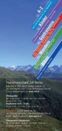
TARIFE<br />
SOMMER/HERBST2013<br />
PRIcES SuMMER/AuTuMN 2013<br />
mit Gästekarte with guest-card ohne Gästekarte without guest-card<br />
Erwachsene<br />
adults<br />
OPENING TIMES 2013<br />
Kinder<br />
children<br />
Jg. 1998-2002<br />
Erwachsene<br />
adults<br />
Kinder<br />
children<br />
Jg. 1998-2002<br />
Rosenalmbahn Zell<br />
Mittelstation - Wiesenalm midstation - Wiesenalm<br />
Bergfahrt - 1 Teilstrecke<br />
car up - 1 section<br />
6,60 3,30 7,40 3,70<br />
Berg- und Talfahrt<br />
up and down<br />
10,80 5,40 12,00 6,00<br />
Bergstation - Rosenalm carstation - Rosenalm<br />
Bergfahrt - 2 Teilstrecken<br />
car up - 2 sections<br />
10,80 5,40 12,00 6,00<br />
Berg- und Talfahrt<br />
up and down<br />
16,20 8,10 18,00 9,00<br />
Gerlossteinbahn<br />
Bergfahrt - 1 Teilstrecke<br />
car up - 1 section<br />
Berg- und Talfahrt<br />
up and down<br />
Ramsberglift<br />
Bergfahrt - 1 Teilstrecke<br />
car up - 1 section<br />
Berg- und Talfahrt<br />
up and down<br />
Isskogelbahn<br />
Bergfahrt - 1 Teilstrecke<br />
car up - 1 section<br />
Berg- und Talfahrt<br />
up and down<br />
Königsleiten Dorfbahn<br />
Bergfahrt - 1 Teilstrecke<br />
car up - 1 section<br />
Berg- und Talfahrt<br />
up and down<br />
Kombiticket für<br />
Wanderer und Biker:<br />
The ideal ticket for mountain<br />
hikers and bikers:<br />
Bergfahrt Zell - Talfahrt Gerlos, Bergfahrt Gerlos - Talfahrt Zell,<br />
Bergfahrt Zell - Bergfahrt Gerlos, Bergfahrt Gerlos - Bergfahrt Zell<br />
Ascent Zell - Descent Gerlos, Ascent Gerlos - Descent Zell, Ascent Zell - Ascent Gerlos, Ascent Gerlos - Ascent Zell<br />
Der Tourismusverband Zell-Gerlos bietet 2 x wöchentlich kostenlos geführte<br />
Wanderungen mit einem geprüften Wanderführer an.<br />
Let the <strong>Arena</strong> Hiking Guide be your compass and ensure you reach your destination safely. Zell-Gerlos Tourist Office<br />
organises free guided hikes with a certified hiking guide two times a week.<br />
Kinder ab dem Jahrgang 2003 fahren in Begleitung kostenlos!<br />
Children born in 2003 or later are free of charge when accompanied by a paying person!<br />
Rosenalmbahn Zell - 25.05.13 - 06.10.13<br />
Tel. 05282/7165<br />
1. Sektion: 8.40 Uhr - 17.10 Uhr, 2. Sektion: 8.40 Uhr - 17.00 Uhr, Mittagspause 12.30 - 13.00 Uhr;<br />
Letzte Zustiegs möglich keit vor der Mit tags pause zur Rosenalm: 12.10 Uhr, zur Mittelstation: 12.20 Uhr,<br />
letzte Bergfahrt 16.30 Uhr; von 07.07 bis einschließlich 22.09.2013 keine Mittagspause /<br />
1. section: 8.40 am - 5.10 pm, 2. section: 8.40 am - 5.00 pm, lunch break: 12.30 pm - 1.00 pm; Last<br />
chance of access before lunch break for Rosenalm: 12.10 pm, for midstation: 12.20 pm, last car up<br />
4.30 pm; from 07 July to 22 September 2013 no lunch break<br />
Gerlossteinbahn - 25.05.13 - 13.10.13<br />
Tel. 05282/2275<br />
8.30 Uhr - 17.00 Uhr halbstündlich, bei Bedarf viertelstündlich, Mittagspause 12.15 - 13.00 Uhr, letzte<br />
Bergfahrt 16.30 Uhr / 8.30 am - 5.00 pm, every 30 min., if necessary every 15 min., lunch break<br />
12.15 pm - 1.00 pm, last car up 4.30 pm<br />
Ramsberglift - 25.05.13 - 29.09.13<br />
Tel. 05282/2720<br />
9.00 Uhr - 17.10 Uhr, stündlich, bei Bedarf durchgehend, Mittagspause 12.15 - 13.00 Uhr, letzte<br />
Bergfahrt 16.30 Uhr / 9.00 am - 5.10 pm, every hour, if necessary continuously, lunch break 12.15<br />
pm - 1.00 pm, last car up 4.30 pm<br />
Isskogelbahn - 15.06.13 - 06.10.13<br />
Tel. 05284/5376<br />
9.00 Uhr - 17.00 Uhr / 9.00 am - 5.00 pm<br />
durchgehend / no lunch break<br />
Königsleiten Dorfbahn - 22.06.13 - 06.10.13<br />
Tel. 06564/8212<br />
9.00 Uhr - 16.00 Uhr stündlich / 9.00 am - 4.00 pm hourly<br />
6,60 3,30 7,40 3,70<br />
10,80 5,40 12,00 6,00<br />
6,60 3,30 7,40 3,70<br />
10,80 5,40 12,00 6,00<br />
7,60 3,80 8,50 4,25<br />
11,70 5,80 13,00 6,50<br />
7,60 3,80 8,50 4,25<br />
11,70 5,80 13,00 6,50<br />
mit Gästekarte with guest-card ohne Gästekarte without guest-card<br />
Erwachsene<br />
adults<br />
Kinder<br />
children<br />
Erwachsene<br />
adults<br />
Kinder<br />
children<br />
13,50 6,80 14,30 7,30<br />
BETRIEBSZEITEn2013<br />
Die Betriebszeiten können witterungsbedingt geändert werden - besonders bei Schlechtwetter und<br />
aufziehenden Gewittern ist ein vorzeitiger Betriebsschluss möglich!<br />
Hours of operation can change due to weather conditions. In case of bad weather or approaching<br />
thunderstorm, earlier end of operation is possible!<br />
Irrtümer und Änderungen vorbehalten! We accept no responsibility for errors and alterations!<br />
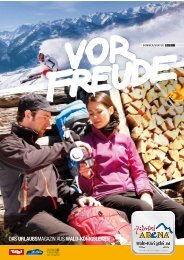
GENuSSAKTIV<br />
IN ZELL IM ZILLERTAL<br />
Zum 9. Mal wird in diesem Sommer das Programm “GenussAktiv” angeboten, welches gezielt alle<br />
menschlichen Sinne anspricht und auf leichte und entspannte Art und Weise das “Erlebnis Berg”<br />
spürbar macht: Von Wanderungen verschiedener Schwierigkeitsgrade, über Themenexkursionen,<br />
bis hin zu einer Lamatrekking-Tour - „GenussAktiv“ bringt Erholung und Abwechslung für die<br />
ganze Familie. Ganz im Zeichen von “GenussAktiv” stehen auch die Themenwege speziell für<br />
Genießer! Das Programm ist kostenlos für Gäste in Mitgliedsbetrieben der <strong>Zillertal</strong> <strong>Arena</strong>!<br />
Zeitraum: 05.05 bis 10.10 2013<br />
This summer, for the 9 th time, the “GenussAktiv” programme is being offered. It targets all the<br />
human senses in a light and relaxed manner and makes the “mountain experience” truly unforgettable.<br />
From hikes of varying levels of difficulty via thematic excursions to a lama trekking<br />
tour, “mountain experience” brings recuperation and variety for the whole family. Already the<br />
trademark “GenussAktiv” itself indicates thematic walks designed especially for those who like to<br />
enjoy themselves! The programme is free for guests of member-accommodations of the <strong>Zillertal</strong><br />
<strong>Arena</strong>. Period: 5 th May to 10 th October 2013<br />
AKTIVWELLnESS ZELL/GERLOS<br />
Aktives Erwachen - Aktives Wohlbefinden. Wellness in den Bergen. Der beste Weg den Alltag<br />
zu vergessen. Im AktivWellness Prospekt finden Sie weitere Informationen und das aktuelle<br />
Wohlfühlprogramm für 2013 unter anderem mit den Programmpunkten Stretch & Relax,<br />
Wellnesswanderung und vieles mehr. Das Programm wird vom 23. Juni bis 27. September 2013<br />
gegen Vorlage der Gästekarte von Zell-Gerlos kostenlos angeboten.<br />
Active awakening - active wellbeing. Wellness in the mountains. The best way to get away from<br />
it all. The Active Wellness brochure includes additional information and the current wellbeing<br />
program for 2013, including Stretch & Relax, Wellness hike and much more. The programme<br />
is offered from 23rd June to 27st September 2013 and is free of charge to holders of the Zell-<br />
Gerlos visitor card.<br />
BERGAKTIV IN GERLOS<br />
BergAktiv ist ein buntes Fit- und Vitalprogramm für Jung und Alt. Ob bei Sonnenschein oder<br />
Regen steht dieses Programm allen Gästen der Gerloser Mitgliedsbetriebe von 23.06. bis<br />
20.09 2013 (jeweils von Sonntag - Freitag) kostenlos zur Verfügung! BergAktiv bietet von lockeren<br />
Einstiegswanderungen (auch Nordic Walking) bis hin zu anspruchsvollen „Stramme Wadel Touren“<br />
ein umfangreiches Berg- und Wanderprogramm an. Hochseilgarten, Canyoning, Rafting und<br />
Themenwanderungen runden das BergAktiv-Programm ab. Also Spaß und Abwechslung für jeden!<br />
„BergAktiv“ is a lively fitness and vitality programme for young and old. Come rain or come<br />
shine, this programme is available free of charge from 23rd June to 20th September 2013 (from<br />
Sunday – Friday) to all guests staying at a partner hotel in Gerlos. The extensive „BergAktiv“<br />
climbing and walking programme ranges from easy beginner walks (also Nordic walking) to<br />
challenging tours to get the muscles into shape. High ropes course, canyoning, rafting and themed<br />
walks complete the Mountain Active programme. Fun and variety for all!<br />
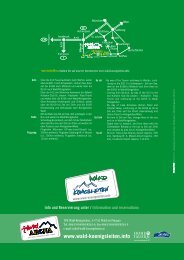
Mehr Informationen zu allen Programmen erhalten Sie beim Tourismusverband Zell-Gerlos:<br />
Further information to all programms you optain at the Touristoffice Zell-Gerlos:<br />
Büro Zell: Dorfplatz 3a, 6280 Zell am Ziller, Tel: +43 (0)5282/2281, Fax: +43 (0) 5282/2281-70<br />
Büro Gerlos: Gerlos 141, 6281 Gerlos, Tel: +43 (0)5284/5244, Fax: +43 (0)5284/5244-24<br />
info@zell-gerlos.at, www.zillertalarena.com<br />
WANDERIDYLLZELLBERG<br />
Marchkopf<br />
<br />
Wedelhütte<br />
Krösser<br />
Pigneidalm<br />
Wimbachkopf<br />
Krössbrunnalm<br />
Zellberg Stüberl<br />
Pigneidalm-Niederleger<br />
Talbach<br />
<br />
<br />
Hirschbichlalm<br />
Öfelerjoch<br />
<br />
Kristallhütte<br />
Grünalm<br />
Furteben<br />
Zu den Wanderzielen zählen der Talbach Wasserfall, die Josefkapelle und die Herz-Jesu-Kapelle, wobei letztere<br />
am Ende des Themenwegs „Holzweg“ zu finden ist. Über den Zellberg gelangt man auf die <strong>Zillertal</strong>er Höhenstraße,<br />
welche einen unvergesslichen Ausblick auf die <strong>Zillertal</strong>er Bergwelt bietet. Sie gehört zu den schönsten Alpenstraßen<br />
Österreichs und führt entlang netter Einkehrmöglichkeiten und Hütten bis auf eine Höhe von 2.020 m<br />
The hiking targets include the “Talbach” waterfall, the Josef Chapel and “Herz-Jesu-Kapelle” (small chapel), both<br />
are located at the theme trail “Holzweg”. Across the Zellberg you reach the “<strong>Zillertal</strong>er Höhenstraße”. Along this<br />
road you will have an incredible view over the mountain range “<strong>Zillertal</strong>er Alpen”. It is one of the most beautiful<br />
alpine roads with nice huts and inns and leads visitors to an altitude of 2,020 m above sea level.<br />
HüTTEn / HUTS ZILLERTALER HÖHEnSTRASSE<br />
Grünalm 1.800 m, Tel. 0664/5257416<br />
Hirschbichlalm 1.840 m, Tel. 0664/5019441<br />
Kristall-Hütte 2.147 m, Tel. 0676/88632400, Do-So geöffnet<br />
Söggen Aste 1.719 m, Tel. 0664/9857129<br />
Wedelhütte 2.350 m, Tel. 0676/88632570, Do-So geöffnet<br />
Zellberg Stüberl 1.835 m, Tel. 0664/3410318<br />
BERGGASTHÖfE / MOUnTAIn RESTAURAnTS ZELLBERG<br />
Gasthof Schulhaus 852 m, Tel. 05282/3376<br />
Gasthaus Zur schönsten Aussicht 760 m, Tel. 05282/2291<br />
<br />
Söggenaste<br />
Söggen<br />
Inneraste<br />
Jelneraste<br />
Afeldbach<br />
ZILLERTALACTIVCARd<br />
6 Tage (6 days) 9 Tage (9 days) 12 Tage (12 days)<br />
Erwachsene / Adults: 55,50 76,00 95,50<br />
Kinder / Children: 27,80 38,00 47,80<br />
Die <strong>Zillertal</strong> Activcard gilt vom 25.05. bis 13.10. 2013 (letzter Gültigkeitstag) an 6, 9 oder<br />
12 aufeinanderfolgenden Tagen. Mit der <strong>Zillertal</strong> Activcard ist pro Tag 1 Berg- und Talfahrt<br />
mit der Seilbahn Ihrer Wahl möglich und Sie können pro Tag 1 Freischwimmbad benützen.<br />
(Depotgebühr pro Chipkarte: A 2,00). Die <strong>Zillertal</strong> Activcard ist gültig für die geöffneten<br />
<strong>Zillertal</strong>er Seilbahnen, die <strong>Zillertal</strong>er Freischwimmbäder, die Sternwarte (+ Planetarium)<br />
Königsleiten sowie für die meisten öffentlichen Verkehrsmittel in der Region, ausgenommen<br />
sind der Dampfzug der <strong>Zillertal</strong>bahn und sämtliche Mautzuschläge. Darüber hinaus gibt es mit<br />
der <strong>Zillertal</strong> Activcard bei vielen Freizeiteinrichtungen und Ausflugszielen ermäßigte Preise,<br />
zum Beispiel beim <strong>Arena</strong> Skyliner beim <strong>Arena</strong> Coaster, im Goldschaubergwerk, beim Action-<br />
Club-<strong>Zillertal</strong> und bei über 50 weiteren heißen Freizeittipps. Kinderermäßigung: Kinder ab<br />
Jahrgang 2007 und jünger werden kostenlos befördert. Kinder der Jahrgänge 2006 bis 1998<br />
bezahlen den Kindertarif. Familienkarte: Beim Kauf von zwei Erwachsenenkarten (Eltern)<br />
fahren deren Kinder (Jahrgang 2006 bis 1998) konstenlos! Für weitere Informationen fordern<br />
Sie einfach die <strong>Zillertal</strong> Activcard Broschüre an.<br />
The <strong>Zillertal</strong> Activcard is valid for a period of 6, 9, or 12 consecutive days between May 25 th<br />
and October 13 th 2013 (expiration date). With the <strong>Zillertal</strong> Activcard, you can make one<br />
ascent and one descent per day using the cableway of your choice, and you can use one<br />
outdoor swimming pool per day. (Deposit per smart card: A 2.00). The <strong>Zillertal</strong> Activcard is<br />
valid for all open <strong>Zillertal</strong> cable cars, the <strong>Zillertal</strong> outdoor pools, the Königsleiten Observatory<br />
(with planetarium), and for most means of public transport within the region: <strong>Zillertal</strong>bahn<br />
steam-train and all tolls excluded. In addition, with the <strong>Zillertal</strong> Activcard you pay reduced<br />
entrance fees at many leisure facilities and outing destinations, such as the <strong>Arena</strong> Skyliner,<br />
<strong>Arena</strong> Coaster, the demonstration gold mine, the <strong>Zillertal</strong> Action Club and an additional of<br />
more than 50 top leisure-time attractions. Child discount: Children born 2007 or later are<br />
carried free of charge. Children born between 2006 and 1998 pay the child rate. Family<br />
cards: When purchasing 2 adult tickets (parents), their children bron in 1998 or later<br />
travel free. For additional information, please request the free <strong>Zillertal</strong> Activcard brochure.<br />
ARENAFuNTEN<br />
WAndERPASS<br />
+++++<strong>Arena</strong>FUNt,<br />
<strong>Arena</strong>FUNt! Für‘s Wandern<br />
bin ich wohl bekannt. Die<br />
Hügel rauf, die Hügel runter in<br />
der Natur fühl‘ ich mich munter.<br />
Nichts ist schöner als die<br />
Berge, satte Wies‘n, frisches Gras.<br />
Darum lieb ich Gipfelstürmen,<br />
Ziegen, Kühe, Almenkas‘. Oben<br />
steh‘n und runter schau‘n, das ist<br />
meine größte Freud‘! Kommt doch<br />
einfach mit am Berg und staunt, Ihr<br />
kleinen Leut‘!+++++ Für Kids der<br />
<strong>Zillertal</strong> <strong>Arena</strong> erhältlich im Büro des<br />
Tourismusverbandes Zell-Gerlos.<br />
Hochstallaste<br />
Neuhaus-Grien<br />
Guggelberg<br />
Dunkelbach<br />
Wasserfall<br />
A-6280 Zell im <strong>Zillertal</strong>, Tel. 0043/(0)5282/7165<br />
www.zillertalarena.com, info@zillertalarena.com<br />
Neuhaus<br />
Reischbach<br />
Gerstberg<br />
Voglaste<br />
<strong>Zillertal</strong>er Höhenstraße<br />
1<br />
1<br />
Plötzeben<br />
Blaser<br />
Hotter<br />
Wimbach<br />
Eden<br />
Kinder ab Jahrgang 2007 FREI<br />
Children born after Jan. 1st of 2007 can travel free.<br />
Bildnachweis: © Archiv <strong>Zillertal</strong> <strong>Arena</strong><br />
Bildnachweis: © Archiv <strong>Zillertal</strong> <strong>Arena</strong><br />
A-6280 Zell im <strong>Zillertal</strong>, Tel. 0043/(0)5282/7165<br />
www.zillertalarena.com, info@zillertalarena.com<br />
A-6280 Zell im <strong>Zillertal</strong>, Tel. 0043/(0)5282/7165<br />
www.zillertalarena.com, info@zillertalarena.com<br />
1<br />
Brandach<br />
Bildnachweis: © Archiv <strong>Zillertal</strong> <strong>Arena</strong><br />
Grünroan<br />
Zellberg<br />
Burbach<br />
Weidach<br />
Laimach<br />
Stein<br />
Musterplatz<br />
Ried<br />
Wimbachboden<br />
ARENAFUNTENWANDERPASS<br />
ARENAFUNTENWANDERPASS<br />
ARENAFUNTENWANDERPASS<br />
<br />
Reisch<br />
Pechleiten<br />
Tiefenbach<br />
Zellbergasten<br />
Gasthof Schulhaus<br />
ZILLERTAL ARENA<br />
ZILLERTAL ARENA<br />
ZILLERTAL ARENA<br />
ZA <strong>Arena</strong>funten Wanderpass 2010 Umschlag-FIN.indd 2 15.06.2010 8:40:55 Uhr<br />
ZA <strong>Arena</strong>funten Wanderpass 2010 Umschlag-FIN.indd 2 15.06.2010 8:40:55 Uhr<br />
ZA <strong>Arena</strong>funten Wanderpass 2010 Umschlag-FIN.indd 2 15.06.2010 8:40:55 Uhr<br />
<br />
Zellbergeben<br />
Leiten<br />
Schöß<br />
Weinberg<br />
Gasthaus Zur Schönsten Aussicht<br />
Zell am Ziller<br />
Maria Rast<br />
KOSTENLOSAnfORdERn<br />
HIKER´S InfO<br />
2013 D/GB<br />
TVB Zell-Gerlos, A-6280 Zell im <strong>Zillertal</strong>, Dorfplatz 3a<br />
Tel. 0043/(0)5282/2281-0, www.zell.at, info@zell-gerlos.at<br />
Servicecenter Gerlos, A-6281 Gerlos 141<br />
Tel. 0043/(0)5284/5244-0, www.gerlos.at, info@zell-gerlos.at<br />
TVB Wald-Königsleiten, A-5742 Wald im Pinzgau<br />
Tel. 0043/(0)6565/8243-0, www.wald-koenigsleiten.info, info@wald-koenigsleiten.at<br />
TVB Krimml/Hochkrimml, A-5743 Krimml<br />
Tel. 0043/(0)6564/7239-0, www.krimml.at, info@krimml.at<br />
A-6280 Zell im <strong>Zillertal</strong>, Infotelefon 0043/(0)5282/7165-226<br />
ORDER AT NO cHARGE<br />
Tel. 0043/(0)5282/7165, Fax 0043/(0)5282/7165-235<br />
E-Mail: info@zillertalarena.com, www.zillertalarena.com<br />
d/E
10<br />
10<br />
11<br />
8<br />
50<br />
50<br />
WANDERuNGENZELL HIKING TRAILS ZELL<br />
Bergtour: Zell im <strong>Zillertal</strong> – Rosenalm – Kreuzjoch<br />
Nach Auffahrt mittels der Rosenalmbahn erreicht man rasch die „Rosenalm“ (1.744 m) - den Ausgangspunkt der Bergtour. Von der Bergstation<br />
der Seilbahn erst auf einem Güterweg kurz talauswärts bis zum ersten Weiderost, dort befindet sich die Wegkreuzung, wo man rechts abbiegt<br />
und dem leicht ansteigenden Güterweg bis zur Gründlalm folgt. Dort befindet sich die nächste Weggabelung, wo man links dem Güterweg<br />
bis zur alten Kreuzjochhütte folgt. Von dort taleinwärts weiter auf dem Güterweg bis zur neuen Kreuzjoch Alm (nur Winterbetrieb). Nach der<br />
Hütte dem neuen Güterweg links folgend, bis kurz vor der Bergstation des Hanser X-PRESS, wo man nun links, auf den Wanderweg trifft,<br />
der über den Bergrücken führt. Nach Querung der Skipiste führt der Wanderweg auf die Südseite des Hanges, bis man wiederum auf den<br />
Bergrücken (Übergangsjoch) gelangt, der bis zum Gipfel des Kreuzjoches (2.558 m) führt. Aufstieg ca. 3 bis 4 Stunden.<br />
Einkehrmöglichkeiten: Simon´s Bergstadl, Kreuzjochhütte, Kreithütte<br />
Mountain tour: Zell im <strong>Zillertal</strong> – Rosenalm – Kreuzjoch<br />
After taking the Rosenalm cable car, you quickly reach Rosenalm (1,744 m), the starting point of the mountain tour. From the cable car top<br />
station briefly follow the road leading out of the valley to the first cattle grid. Here at the trail junction, turn right and follow the road which<br />
slowly climbs to Gründlalm, where the next fork in the trail is located. There you should take the road to the left to the old Kreuzjochhütte.<br />
From there continue further on the road into the valley until you reach the new Kreuzjoch Alm (only open in winter). After the hut, follow<br />
the new road to the left until shortly before the top station of the Hanser X-PRESS, where if you stay to the left, you will meet up with the<br />
trail which goes over the mountain ridge. After crossing the ski slope, the trail leads you on the south side of the slope until you again reach<br />
the mountain ridge (Übergangsjoch), which takes you to the Kreuzjoch summit with an elevation of 2,558 m. Ascent approx. 3 to 4 hours.<br />
Refreshments: Simon´s Bergstadl, Kreuzjochhütte, Kreithütte<br />
Kleine Rundwanderung: Rosenalm – Gründlalm (1.831 m) – Rosenalm<br />
Von der Bergstation der Rosenalmbahn rechts, am Bergrestaurant „Rosenalm“ (nur Winterbetrieb) vorbei, wo leicht ansteigend ein Wanderweg<br />
erst über die Skipiste, dann durch einen Zirben- und Fichtenwald führt, wo man nach ca. einer halben Stunde auf einen Güterweg trifft.<br />
Von dort links dem Güterweg folgend, gelangt man in kurzer Zeit zur Gründlalm (Wegkreuzung). Geht man auf dem rechten Güterweg<br />
weiter, erreicht man ca. nach einer halben Stunde die alte Kreuzjochhütte. Folgt man dem linken Güterweg, erreicht man wiederum den<br />
Ausgangspunkt - die Rosenalm. Gehzeit ca. 1 1/2 Stunden. Einkehrmöglichkeiten: Simon´s Bergstadl, Kreuzjochhütte, Kreithütte<br />
Short circular hike: Rosenalm – Gründlalm (1,831 m) – Rosenalm<br />
From the top station of the Rosenalm cable car turn right, go past the Bergrestaurant „Rosenalm“ (only open in winter), where a trail slowly<br />
climbs across the ski slope. It then goes through a pine and spruce forest, where after about half an hour you meet a road. From there, take a<br />
left on the road and you will quickly reach Gründlalm (trail junction). If you take a right at that junction, you will reach the old Kreuzjochhütte<br />
in about half an hour. If you take a left at that junction, you will again reach the starting point, Rosenalm. Walking time about 1 1/2 hours.<br />
Refreshments: Simon´s Bergstadl, Kreuzjochhütte, Kreithütte<br />
Große Rundwanderung: Rosenalm – Karspitz – (2.135 m) – Kreuzwiesenalm – Rosenalm<br />
Von der Bergstation der Rosenalmbahn wie Bergtour „Kreuzjoch“ bis zur neuen Kreuzjoch Alm (nur Winterbetrieb). Dann weiter auf dem<br />
taleinwärts führenden Güterweg, der direkt auf den Fußweg zum Gipfel des Karspitzes führt. Vom Gipfel ca. 100 m abwärts dem Weg<br />
des Aufstieges folgend, dann rechts abbiegend am Roßsee vorbei bis zu den Karhütten, wo man wieder auf einen Güterweg trifft. Diesem<br />
folgt man bis zur letzten Kehre. Nach der Überquerung des kleinen Bächleins führt ein Fußweg wiederum auf den Wirtschaftsweg zur<br />
Kreuzwiesenalmhütte. Dem Wirtschaftsweg oberhalb der Hütte folgend, bis eine kleine Weggabelung links auf einen schmalen Fußweg bis zur<br />
Rosenalm führt. Gehzeit ca. 5 bis 6 Stunden. Einkehrmöglichkeiten: Simon´s Bergstadl, Kreuzjochhütte, Kreuzwiesenalmhütte, Kreithütte<br />
Long circular hike: Rosenalm – Karspitze – (2,135 m) – Kreuzwiesenalm – Rosenalm<br />
From the top station of the Rosenalm cable car, take the same route as for the mountain tour „Kreuzjoch“ until you reach the new Kreuzjoch<br />
Alm (only open in winter). From the new Kreuzjoch Alm, continue on the road leading into the valley which brings you direct to the trail to the<br />
Karspitze summit. From the summit follow the same trail back down for about 100 m, then turn right and go past Rosssee to the Karhütten,<br />
where you again meet up with a road. Follow this to the last switchback. After crossing a small stream, follow the road Kreuzwiesenalmhütte.<br />
Take the road above the hut to a small fork in the road. The left fork leads you to Rosenalm on a narrow trail. Walking time approx. 5 to 6<br />
hours. Refreshments: Simon´s Bergstadl, Kreuzjochhütte, Kreuzwiesenalmhütte, Kreithütte<br />
Bergtour: Gerlossteinwand (2.166 m)<br />
Mit dem Auto oder Bus bis nach Hainzenberg zur Talstation der „Gerlossteinbahn“. Mit der Seilbahn gelangt man rasch zum Ausgangspunkt<br />
der Bergtour - zum Berghotel Gerlosstein. Direkt an der Ausstiegsstelle der Bergstation beginnt der Wanderweg in Blickrichtung rechts von<br />
der Gerlossteinwand (etwas steilerer Anstieg, als Abstieg nicht so geeignet). Nach ca. einer halben Stunde Gehzeit erreicht man eine kleine<br />
Weggabelung unterhalb von zwei kleinen Holzhütten. Geht man den Weg gerade aus, so nimmt man den steileren Anstieg (1 1/2 Stunden).<br />
Benützt man den rechten Weg, gelangt man nach kurzer Zeit auf den Sattel des Arbiskogel (1.830 m), wo zur linken Hand der etwas leichtere<br />
Weg zum Gipfel führt (jedoch ca. 1/2 Stunde längere Gehzeit zum Gipfel). Gehzeit ca. 2 Stunden. Der Rückweg führt vom Gipfel abwärts<br />
Richtung Freikopf, Weggabelung links, ein kurzer Anstieg (5 min), bis zur Scharte, von dort abwärts über das Steinkar bis zum Heimjöchl.<br />
Vom Heimjöchl den linken Wanderweg talwärts bis zum Ausgangspunkt zurück. Gehzeit Gerlossteinwand zum Ausgangspunkt der Wanderung<br />
(ca. 1 1/2 Stunden). Einkehrmöglichkeiten: Berghotel Gerlosstein<br />
Mountain tour: Gerlossteinwand (2,166 m)<br />
Take the car or the bus to Hainzenberg - Gerlosstein cable car bottom station. By taking the cable car you quickly reach Berghotel Gerlosstein,<br />
the starting point of the mountain tour. The trail begins immediately at the exit of the top station when you look to the right of Gerlossteinwand<br />
(a somewhat steep ascent, not suitable for descent). After walking about half an hour you reach a small fork in the trail below two small<br />
wood huts. If you go straight, you take the steeper ascent (1 1/2 hours). If you take the trail to the right, you reach the Arbiskogel (1,830<br />
m) saddle after a short amount of time, where off to the left there is a somewhat easier trail to the summit. (however it’s about 1/2 hour<br />
longer to the summit). Walking time approx. 2 hours. The return trip leads downward from the summit in the direction of Freikopf. Take<br />
the left fork, ascend for 5 minutes to the wind gap. From there descend to Heimjöchl via Steinkar. From Heimjöchl follow the trail to the left<br />
back down to the starting point. Walking time from Gerlossteinwand to the starting point of the hike approx. 1 1/2 hours. Refreshments:<br />
Berghotel Gerlosstein<br />
Ramsau – Sonnalm – Rundwanderung<br />
Von Ramsau mit dem Ramsberglift auf die Sonnalm. Von hier beginnt nun die Rundwanderung entlang des Güterweges taleinwärts bis zur<br />
ersten Kehre, wo sich ein Gatter befindet. Diesen überquert man und folgt dem etwas verwachsenen Güterweg, der direkt auf den Fußweg<br />
zur Hütte Kotahorn Alm führt. Von hier folgt man dem Wirtschaftsweg talauswärts, der direkt zum Berghotel Gerlosstein führt. Kurz vor dem<br />
Hotel ist eine Weggabelung des Güterweges, wandert man links talwärts, kommt man wieder zum Ausgangspunkt der Wanderung zurück.<br />
Gehzeit ca. 2 1/2 bis 3 Stunden. Einkehrmöglichkeiten: Sonnalm, Kotahorn Alm, Berghotel Gerlosstein<br />
Ramsau – Sonnalm – circular hike<br />
Take the Ramsberg lift from Ramsau to Sonnalm. From here the loop begins on the road leading into the valley. Take it to the first switchback,<br />
where there is a cattle grid. Cross this and follow the somewhat overgrown road, which leads you on the trail direct to Kotahorn Alm.<br />
From here you follow the road leading out of the valley, which takes you direct to Berghotel Gerlosstein. Shortly before the mountain hotel<br />
there is a fork in the road. If you follow it, you come back again to the starting point of the hike. Walking time approx. 2 1/2 to 3 hours.<br />
Refreshments: Sonnalm, Kotahorn Alm, Berghotel Gerlosstein<br />
Gerlosstein – Brandberg – Steinerkogel<br />
Ausgangspunkt wie bei der Bergtour „Gerlossteinwand“. Ab dem Berghotel Gerlosstein führen zwei Wege in Richtung Süden. Dem oberen<br />
Wirtschaftsweg folgend, gelangt man zur Hütte Kotahorn Alm. Direkt unter der Hütte beginnt der Fußweg taleinwärts, der erst zur Karlalm<br />
und in Folge zur Labergalm führt. Von der Labergalm dem Hangrücken talwärts folgend, führt der Wanderweg an Hütten vorbei und durch<br />
ein Waldstück, wo der Wanderweg öfters einen Wirtschaftsweg quert. Nach Verlassen des Waldes erblickt man bereits das Steinerkogelhaus.<br />
Unterhalb des Steinerkogelhauses ist eine Wegkreuzung, geht man rechts, gelangt man vom Wegkreuz nach<br />
ca. 1 1/2 Stunden nach Mayrhofen. Folgt man dem Weg gerade, erreicht man nach ca. 1/2 Stunde die Ortschaft Brandberg. Bushaltestelle.<br />
Gehzeit nach Brandberg ca. 3 Stunden, Gehzeit nach Mayrhofen ca. 4 Stunden. Einkehrmöglichkeiten: Berghotel Gerlosstein, Kotahorn<br />
Alm, Karlalm, Steinerkogelhaus<br />
Gerlosstein – Brandberg – Steinerkogel<br />
The same route to the starting point of the „Gerlossteinwand“ mountain tour. From the Berghotel Gerlosstein there are two paths which lead to<br />
the south. The higher road takes you to Kotahorn Alm. Immediately below the hut a trail begins which leads into the valley, first to Karlalm and<br />
then to Labergalm. From Labergalm follow the ridge downhill. The trail leads past huts through a forested area, where the trail often crosses<br />
a road. When you leave the forest, you can already see Steinerkogelhaus. Below Steinerkogel haus there is a trail junction. If you go to the<br />
right, you reach Mayrhofen in about 1 1/2 hours from the junction. If you follow the trail straight ahead, you reach the village of Brandberg<br />
in about 1/2 hour. Bus stop. Total walking time to Brandberg approx. 3 hours. Total walking time to Mayrhofen approx. 4 hours.<br />
Refreshments: Berghotel Gerlosstein, Kotahorn Alm, Karlalm, Steinerkogelhaus<br />
<strong>Arena</strong> Coaster in Zell<br />
SOMMERPARAdIES Ausführliche<br />
HüTTEn / HUTS AM KREUZjOCH<br />
Grindlalm 1.150m, Tel. 05282/2339<br />
Kreithütte (Kleine Rosenalm) 1.700 m, Tel. 0664/3213663<br />
Kreuzjochhütte 1.980 m, Tel. 0664/3075448<br />
Schmankerlhütte Kreuzwiesenalm 1.880 m, Tel. 0664/2342646<br />
Simon’s Bergstadl 1.744 m, Tel. 05282/4116<br />
Wiesenalm 1.309 m, Tel. 05282/2560<br />
HüTTEn / HUTS AM ISSKOGEL<br />
Latschenalm 1.950 m, Tel. 0664/4132545<br />
Rössl Alm 1.600 m, Tel. 0664/1475000<br />
<strong>Arena</strong> Skyliner - das neue<br />
Fluggerät am Gerlosstein<br />
HüTTEn / HUTS AM GERLOSSTEIn<br />
Alte Kotahorn Alm 1.630 m, Tel. 0664/3429800<br />
Berghotel Gerlosstein 1.620 m, Tel. 0664/3490349<br />
Neue Kotahorn Alm 1.624 m, Tel. 05282/2309<br />
Sonnalm 1.350 m, Tel. 05282/3689<br />
Gerlossteinalm 1.630 m, Tel. 0664/1537781<br />
HüTTEn / HUTS In KÖnIGSLEITEn<br />
Larmachalm 1.896 m, Tel. 0664/3817807<br />
Gipfeltreffen 2.260 m, Tel. 06564/8212<br />
Panoramaalm 2.159 m, Tel. 0664/1332552<br />
Kneipp-Wasserspielanlage Hainzenberg<br />
Kneipp/water play area at Hainzenberg<br />
*<br />
Klettersteig Gerlossteinwand<br />
Fixed-rope climbing route „Gerlossteinwand“<br />
Wanderkarten können Sie bei den Talstationen<br />
der Bergbahnen oder bei den Tourismusverbänden kaufen.<br />
Hiking maps can be bought at the bottom station of the<br />
cable cars or at the tourist office.<br />
HüTTEn / HUTS IM SALZACHTAL<br />
Salzachhütte 1.795 m, Tel. 06565/6403<br />
HüTTEn In dEn SEITEnTäLERn VOn GERLOS /<br />
ALPInE HUTS In THE SIdE VALLEYS Of GERLOS<br />
Bärschlagalm 1.459 m, Tel. 0676/5361647<br />
Krummbachrast 1.480 m, Tel. 0676/9208813<br />
Lackenalm 1.405 m, Tel. 0664/4050204<br />
Prölleralm 1.400 m, Tel. 0650/3006290<br />
Schwarzachalm 1.378 m, Tel. 0676/3354954<br />
Seestüberl 1.411 m, Tel. 0664/4413588<br />
Stackerlalm 1.850 m, Tel. 0664/4038673<br />
Wimmertalalm 1.380 m, Tel. 0664/9154274<br />
Hochseilgarten Gerlos<br />
High ropes garden in Gerlos<br />
HüTTEn / HUTS In HOCHKRIMML<br />
Gletscherblickalm 1.880 m, Tel. 0664/2735127<br />
Bergrestaurant Duxeralm 1.645 m, Tel. 06564/8326<br />
Alpengasthof Filzstein 1.641 m, Tel. 06564/8318<br />
Schönmoosalm 1.434 m, Tel. 06564/7272<br />
HüTTEn / HUTS IM KRIMMLER ACHEnTAL & WILdGERLOSTAL<br />
Gasthof Finkau 1.420 m, Tel. 06564/8380<br />
Hölzlahneralm 1.590 m, Tel. 0664/4026878<br />
Krimmler Tauernhaus 1.622 m, Tel. 0664/2612174<br />
Richter Hütte 2.374 m, Tel. 06564/7328<br />
Söllnalm 1.585 m, Tel. 06564/7310<br />
Warnsdorfer Hütte 2.336 m, Tel. 06564/8241<br />
Zittauer Hütte 2.330 m, Tel. 06564/8262<br />
Trisslalm 1.583 m, Tel. 0664/4954499<br />
WLANHOTSPOTS<br />
WANDERuNGENGERLOS HIKING TRAILS GERLOS<br />
Aktivierung richtet sich nach den jeweiligen Öffnungszeiten<br />
Activation depends on opening times<br />
Zell: Rosenalmbahn Berg-, Mittel- & Talstation, <strong>Arena</strong> Bistro, Sonnalm (Gerlosstein), Kreuzwiesenalm<br />
Gerlos: Isskogelbahn Talstation, <strong>Arena</strong> Center, Rössl Alm, Prölleralm<br />
Königsleiten: Dorfbahn Berg- & Talstation, Gipfeltreffen, Larmachalm<br />
Hochkrimml: Alpengasthof Filzstein und Restaurant Duxeralm<br />
Krimml: Wasserfestspiele<br />
Zell: Rosenalmbahn top, middle & base station, <strong>Arena</strong> Bistro, Sonnalm (Gerlosstein), Kreuzwiesenalm<br />
Gerlos: Isskogelbahn base station, <strong>Arena</strong> Center, Rössl Alm, Prölleralm<br />
Königsleiten: Dorfbahn top & base station, Gipfeltreffen, Larmachalm<br />
Hochkrimml: Alpengasthof Filzstein und Restaurant Duxeralm<br />
Krimml: Wasserfestspiele<br />
fREE WLAn<br />
HOTSPOTS<br />
511<br />
7<br />
2<br />
Bergwanderung: Gerlos – Schönachtal – Lackenalm –<br />
Stackerlalm<br />
Beim Gasthof Oberwirt überqueren Sie die Brücke des Gerlosbaches und<br />
wandern entlang des Fahrweges in das romantische flach ansteigende<br />
Schönachtal zur Stinkmoosalm mit herrlichem Blick auf vergletscherte<br />
3000er und weiter bis zur Jausenstation Lackenalm (bewirtschaftet).<br />
Nach weiteren rund 1 ½ Kilometer biegt an der Issalm ein Güterweg<br />
(Nr. 7) rechts ab, hinauf in Serpentinen Richtung Stackerlalm. Nach dem<br />
Sie den Waldgürtel hinter sich gelassen haben, eröffnet sich auf rund<br />
1850 m ein herrlicher Blick auf das Schönachkees und die rechts unten<br />
liegende Stackerlalm. Die Stackerlalm ist während des Almsommers (Juli<br />
/ August bis Anfang September) bewirtschaftet (Samstags Ruhetag).<br />
Gehzeit ca. 2 ½ Stunden (einfach) / ca. 5 Stunden (hin- & retour)<br />
Mountaintour: Gerlos – Schönachtal – Lackenalm –<br />
Stackerlalm<br />
Cross the bridge over the Gerlosbach stream beside Gasthof Oberwirt<br />
and follow the track into the picturesque, gently ascending Schönachtal<br />
valley to the Stinkmoosalm hut, where you can enjoy a breathtaking<br />
view of glaciated 3,000-metre peaks before continuing on to the<br />
Lackenalm Alpine hut, where you can stop for a bite to eat. After a<br />
further 1 1/2 kilometres, a winding agricultural road (nr. 7) at the<br />
Issalm branches off to the right taking you up towards the Stackerlalm<br />
mountain hut. After leaving the belt of woodland behind you, at an<br />
elevation of around 1,850 m, a stunning view of the Schönachkees<br />
glacier, and the Stackerlalm down to your right, opens up before<br />
you. The Stackerlam is open for food and drink during the pasture<br />
grazing months (July / August until the beginning of September - closed<br />
Saturdays). Walking time: approx. 2 1/2 hours (one-way) / approx.<br />
5 hours (there & back)<br />
Isskogel – Wilde Krimml – Krummbachtal<br />
Wanderung auf den Isskogel. Von der Bergstation der Isskogelbahn<br />
führt der Wanderweg der Markierung 1 über das Ebenfeld in 11/2<br />
Stunden zum Isskogelgipfel auf 2.264m. Weiter der Nr. 1 folgend<br />
steigt man nach ca. 10 Gehminuten in östlicher Richtung zur „Wilden<br />
Krimmlalm“ ab. Von der Krimmlalm etwas steiler abwärts führt der<br />
Weg nun der Markierung Nr. 2 folgend durch das wildromantische<br />
sogenannte „Wilde Teufeltal“ über die Arzlahner Alm, an dieser<br />
rechts abbiegend durch den Wald zur Jausenstation Krummbachrast.<br />
Von hier führt der Weg talauswärts nach Gerlos. Gesamtgehzeit ca.<br />
4 Stunden.<br />
Isskogel – Wilde Krimml – Krummbachtal<br />
Hiking up to the Isskogel. From the top station of the Isskogel cable car<br />
follow the trail markings No. 1 via Ebenfeld to Isskogel at 2,264 m in 1<br />
1/2 hrs. Continue along Trail No. 1, going east for about 10 minutes,<br />
and then downhill to the „Wilde Krimmlalm“. From the Krimmlalm<br />
take the somewhat steeper descent along Trail No. 2 to the wildly<br />
romantic valley known as „Wildes Teufeltal“ (Wild Devil Valley), past<br />
the Arzlahner Alm, where the trail turns right through the forest to the<br />
Jausenstation Krummbachrast (snacks). From here the trail leads out<br />
of the valley to Gerlos. Total hiking time: approx. 4 hrs.<br />
Das Gerlostal kann auch als „Tal der Täler“ bezeichnet werden.<br />
Denn von hier zweigen sich noch fünf weitere Seitentäler ab; echte<br />
Highlights für aktive Urlauber - für den gemütlichen ebenso wie<br />
für den sportlichen ambitionierten Wanderer. Der allemal lohnende<br />
Tagesausflug in eines dieser „Seitental-Schmankerln“ des Ferienortes<br />
Gerlos wird natürlich auf Schritt und Tritt begleitet von glasklaren, leise<br />
murmelnden Bächen, die vor allem an sehr warmen Tagen immer zur<br />
Erfrischung einladen. Und: Durch alle fünf Täler ziehen sich höchst<br />
abwechslungsreiche Routen. Zunächst durchwegs ziemlich sanft, werden<br />
die Wege und Steige später dann zunehmend herausfordernder,<br />
um an ihrem Ende teilweise sogar alpine Erfahrung zu fordern.<br />
The Gerlos Hiking <strong>Arena</strong> can well be called the „valley of the valleys“.<br />
Because branching from the peaceful Gerlos Valley are five side valleys,<br />
the perfect thing for active holiday-makers - for the happy-go-lucky<br />
and/or the ambitious walker. Any of the always rewarding day excursions<br />
to one of these „side valley treats“ is naturally accompanied by<br />
crystal-clear, babbling brooks, where you can spend idyllic hot summer<br />
days. And: all of the five valleys have very different hiking trails.<br />
They all start out pretty gently, only to become more challenging and<br />
sometimes even require mountaineering experience.<br />
Schwarzachtal – Jausenstation/Snack bar 45 Min.<br />
Wimmertal – Jausenstation/Snack bar 1 h<br />
Schönachtal – Jausenstation/Snack bar 1 h<br />
Wildgerlostal – Rundwanderung/Circular hike<br />
„Gerlosstausee“ 3 h<br />
Krummbachtal – Jausenstation/Snack bar 1 h<br />
WANDERuNGENKRIMML / WALd HIKING TRAILS KRIMML/WALD<br />
Infos zu den kostenlosen, geführten Wanderungen erhalten Sie in den Tourismubüros in Krimml und Wald. / Get informations about free guided hiking tours at the tourist information Krimml and Wald.<br />
519 Wanderparadies Krimmler Achental / Krimml Achental Walking Paradise<br />
731 Gernkogel (2.267 m)<br />
Von der Ortsmitte Krimml (gebührenfreier Parkplatz) führt unsere Wanderung dem Aussichtsweg der Krimmler Wasserfälle entlang bis zum<br />
Vom Walder Ortszentrum führt der Weg nach Norden zum Schulhaus<br />
obersten Wasserfall (Gehzeit 1,5 Stunden, E 2,50/E 0,50 für Kinder). Hier beginnt das Krimmler Achental – eines der schönsten Hochtäler<br />
und weiter bis zum Güterweg oder ab Wald die alte Gerlosstraße bis<br />
im Nationalpark Hohe Tauern – mit einer Gesamtlänge von 12 km. In der Mitte dieses Tales liegt das Krimmler Tauernhaus in 1.631m<br />
zur Mühlbrücke, weiter nach rechts auf den Walder Sonnberg zum<br />
(Gehzeit 1,5 Std.) Dem Weg zwischen saftigen Almböden und der Krimmler Ache folgend erreichen wir den imposanten Talschluss, mit<br />
Ederbauer. Über den Forstweg oder über einen Steig gelangt man<br />
einem herrlichen Blick auf den Krimmler Kees und zahlreichen Dreitausendern (Gehzeit 2 Std.). Von hier führt uns ein Wandersteig direkt<br />
zur Wurfgrundalm und weiter geht’s dem Gipfelkreuz des Walder<br />
zur Warnsdorfer Hütte in 2.324 m (Gehzeit 1,5 Std.). 10 Gehminuten von der Hütte entfernt treffen Sie auf ein besonderes Naturschauspiel,<br />
Hausberges, dem Gernkogel, entgegen. Weg Nr. 1 und 1A, ÖAV<br />
einem einzigartigen Eissee. Hinweis: Taxifahrten zum bzw. vom Tauernhaus in Richtung Krimml sind möglich.<br />
Weg 731. Gehzeit ca. 4,5 Stunden<br />
From Krimml town centre (free parking), our walk follows the scenic path along the Krimml waterfalls to the highest waterfall (walking time 1.5<br />
From Wald town centre, the path leads north to the Schulhaus (school<br />
hours, E 2,50/E 0,50 for children). The Krimml Achental valley, one of the most beautiful high valleys in the Hohe Tauern National Park with a<br />
house) and then on to Güterweg, or from Wald, take the old Gerlosstrasse<br />
total length of 12 km, starts here. The Krimmler Tauernhaus mountain restaurant lies in the middle of the valley at an altitude of 1,631m (walking<br />
to Mühlbrücke bridge and continue right on the Sonnberg to Ederbauer. Take<br />
time 1.5 hrs). Following the path between lush mountain pastures and the Krimml Ache river, we reach the impressive valley head with a view of<br />
either the forest path or a steep track to reach the Wurfgrundalm mountain<br />
the Krimmler Kees glacier. and several 3,000m peaks (walking time 2 hrs). From here, a steep track leads directly to the Warnsdorfer mountain hut<br />
hut and then continue towards the peak cross on the local Wald mountain, the<br />
at 2,324 m (walking time 1.5 hrs). 10 minutes walk from the hut, you come across a extraordinary natural spectacle, a unique ice lake. Note: It is<br />
Gernkogel. Route no. 1 and 1A, ÖAV (Austrian Alpine Club) route 731.<br />
possible to take a taxi to and from the Tauernhaus restaurant towards Krimml<br />
Walking time approx. 4.5 hours<br />
8<br />
6<br />
7<br />
540<br />
2<br />
*