101 km Entre Mont Ste Odile et Ht-Koenigsbourg Die ... - Cadr67
101 km Entre Mont Ste Odile et Ht-Koenigsbourg Die ... - Cadr67
101 km Entre Mont Ste Odile et Ht-Koenigsbourg Die ... - Cadr67

Sie wollen auch ein ePaper? Erhöhen Sie die Reichweite Ihrer Titel.
YUMPU macht aus Druck-PDFs automatisch weboptimierte ePaper, die Google liebt.
Janvier 2010 2008<br />
Le Bas-Rhin en roue libre / Mit dem Fahrrad durch das Unterelsass / Cycling through Northern Alsace<br />
L'Alsace à vélo<br />
Tours cyclo<br />
Fahrradrundwege<br />
Circular cycle trails<br />
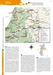
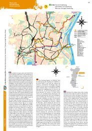
Au sud-ouest de Strasbourg, le pays de<br />
Barr déploie ses collines, ses vignes <strong>et</strong> ses villages<br />
prospères. Après Barr, capitale viticole du Bas-<br />
Rhin, le circuit mène au <strong>Mont</strong> Sainte-<strong>Odile</strong>,<br />
promontoire couvert de forêt <strong>et</strong> chapeauté au<br />
somm<strong>et</strong> d'abruptes falaises de grès rose. En<br />
contrebas, le village du Hohwald vous accueille au<br />
milieu d'une vaste clairière. La montée du col du<br />
Kreuzweg ouvre sur le Val de Villé. Elle est suivie<br />
d'une descente vertigineuse vers la vallée de la<br />
Liepvr<strong>et</strong>te. La route conduit alors au château du<br />
Haut-<strong>Koenigsbourg</strong> qui, du haut de son éperon,<br />
culmine à près de 755 m d'altitude. Le r<strong>et</strong>our s'opère<br />
tranquillement à travers le vignoble.<br />
Entouré de l'énigmatique mur païen, le <strong>Mont</strong><br />
Sainte-<strong>Odile</strong> est le lieu de pèlerinage le plus<br />
important d'Alsace. Le Val de Villé, patrie du célèbre<br />
kirsch, propose de beaux paysages ouverts, propices<br />
à la pratique du parapente. On s'attardera ensuite<br />
au château du Haut-<strong>Koenigsbourg</strong> superbement<br />
restauré. La vue est imprenable <strong>et</strong> par temps clair<br />
on peut, paraît-il, y apercevoir le <strong>Mont</strong> Blanc. Au<br />
pied du château, le village de Kintzheim est célèbre<br />
pour la Volerie des Aigles <strong>et</strong> la <strong>Mont</strong>agne des<br />
Singes. À Châtenois, arrêtez-vous devant la Tour des<br />
Sorcières, témoignage de l'enceinte fortifiée. Enfin, à<br />
Andlau, on admirera l'église abbatiale, chef-d’œuvre<br />
de l'art roman.<br />
Le parcours/Der Weg/The route<br />
Localités<br />
Orte - Towns<br />
19<br />
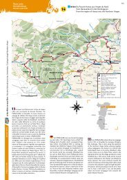
Im Südwesten Straßburgs erstreckt sich die<br />
hügelige Landschaft des Pays de Barr, dessen Weinberge<br />
den umliegenden Dörfern einen gediegenen<br />
Wohlstand verleihen. Ein relativ stark ansteigender<br />
Weg führt von Barr bis zum <strong>Mont</strong> <strong>Ste</strong>. <strong>Odile</strong>, wo<br />
man eine berühmte Wallfahrtsstätte besichtigen<br />
kann. Am Fuße des Berges erwart<strong>et</strong> Sie das gastliche<br />
Dorf Le Hohwald, das in einer anmutigen Lichtung<br />
eingeb<strong>et</strong>t<strong>et</strong> liegt. Anschließend erfolgt der Anstieg<br />
über den Col du Kreuzweg. <strong>Die</strong>ser Paß führt zum<br />
Val de Villé, einer Hochburg der Obstbrennerei.<br />
Weiter gelangt man zur Burg Haut-<strong>Koenigsbourg</strong><br />
(755 m), von wo aus man eine unvergleichliche<br />
Aussicht genießen kann. Am Fuße der Burg lockt<br />
das Dorf Kintzheim mit weiteren Attraktionen:<br />
dem Adler-Freifluggelände «Volerie des Aigles»<br />
und dem Affenfelsen «<strong>Mont</strong>agne des Singes». In<br />
Châtenois sollten Sie unbedingt einen Halt vor dem<br />
Hexenturm «Tour des Sorcières» vorsehen. <strong>Die</strong><br />
Rückfahrt bewerkstelligt man bequem auf einem<br />
relativ flachen, von Weinbergen umgebenen Weg.<br />
Eine weitere Station sollte man in Andlau einlegen,<br />
um die Abteikirche zu bewundern, die ein wahres<br />
Meisterwerk romanischer Baukunst ist.<br />
Partiel<br />
Teilabschnitt<br />
Partial<br />
Total<br />
Gesamt<br />
Total<br />
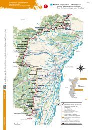
<strong>101</strong> <strong>km</strong> <strong>Entre</strong> <strong>Mont</strong> <strong>Ste</strong> <strong>Odile</strong> <strong>et</strong> <strong>Ht</strong>-<strong>Koenigsbourg</strong><br />
<strong>Die</strong> Berglandschaft zwischen dem Odilienberg<br />
und der Hoch Koenigsburg<br />
From Mount St <strong>Odile</strong> to the Haut-<strong>Koenigsbourg</strong><br />
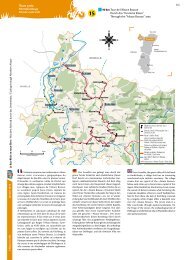
To the south-west of Strasbourg, spread the<br />
hills, vineyards and the prosperous villages of the<br />
Barr country. A steep road leads the cyclist from<br />
Barr to the <strong>Mont</strong> Sainte-<strong>Odile</strong>, an important place<br />
of pilgrimage. Down below, the village of Le Hohwald<br />
welcomes you in a vast clearing before you ride up<br />
the Kreuzweg pass (col du Kreuzweg). It opens onto<br />
the Val de Villé valley, the land of fruit brandies.<br />
Descending the Liepvr<strong>et</strong>te valley leads you to the<br />
superb Haut-<strong>Koenigsbourg</strong> Castle (755 m), with its<br />
grandiose panoramic views. At the foot of the castle,<br />
the village of Kintzheim is famous for its Eagle Centre<br />
(Volerie des Aigles) and the <strong>Mont</strong>agne des Singes<br />
monkey reserve. At Châtenois, stop off in front of<br />
the Witches' Tower (Tour des Sorcières). The r<strong>et</strong>urn<br />
journey is a peaceful one through the vineyards. A<br />
stop in Andlau is a must to admire the abbey church,<br />
a masterpiece of Romanesque art.<br />
Barr • - 0 <strong>km</strong> 0 <strong>km</strong> ◆ ◆ ◆ ◆ ◆ ◆ Ep-Be-Bo ◆ ◆ ◆<br />
<strong>Mont</strong> Sainte <strong>Odile</strong> D854/D426 11,0 <strong>km</strong> 11,0 <strong>km</strong> ◆ ◆<br />
Le Hohwald D426 11,0 <strong>km</strong> 22,0 <strong>km</strong> ◆ ◆ ◆ ◆ ◆ ◆ Ep-Be ◆<br />
Col du Kreuzweg Rte Wittertalhof/D425 5,0 <strong>km</strong> 27,0 <strong>km</strong> ◆ ◆<br />
Breitenbach D425 5,9 <strong>km</strong> 32,9 <strong>km</strong> ◆ Be<br />
Saint Martin D425 2,2 <strong>km</strong> 35,1 <strong>km</strong> ◆<br />
Villé D424 1,4 <strong>km</strong> 36,5 <strong>km</strong> ◆ ◆ ◆ ◆ ◆ Ep-Be-Bo ◆ ◆ ◆ ◆<br />
Triembach-au-Val D424(BC) 1,9 <strong>km</strong> 38,4 <strong>km</strong> ◆ ◆ Be ◆<br />
Saint Maurice D424(BC) 1,6 <strong>km</strong> 40,0 <strong>km</strong> ◆<br />
Hirtzelbach D997 0,8 <strong>km</strong> 40,8 <strong>km</strong><br />
<strong>Die</strong>ffenbach au Val D997/D697 1,4 <strong>km</strong> 42,2 <strong>km</strong> ◆ ◆ ◆ Ep-Be<br />
Neubois D697 1,6 <strong>km</strong> 43,8 <strong>km</strong> ◆ ◆<br />
Hurst D697/RF(IC) 4,2 <strong>km</strong> 48,0 <strong>km</strong><br />
La Vancelle D167 3,8 <strong>km</strong> 51,8 <strong>km</strong> ◆ ◆ ◆<br />
Liepvre C1 2,7 <strong>km</strong> 54,5 <strong>km</strong> ◆ ◆ Ep-Be-Bo ◆ ◆<br />
Haut-<strong>Koenigsbourg</strong> D48I/D42/D1bisI/D159 10,5 <strong>km</strong> 65,0 <strong>km</strong> ◆ ◆<br />
Kintzheim D159 8,2 <strong>km</strong> 73,2 <strong>km</strong> ◆ ◆ ◆ Be-Bo ◆<br />
Châtenois D35 1,9 <strong>km</strong> 75,1 <strong>km</strong> ◆ ◆ ◆ ◆ Ep-Be-Bo ◆ ◆ ◆<br />
Huhnelmuhle D35 2,9 <strong>km</strong> 78,0 <strong>km</strong> ◆ ◆ ◆ ◆ ◆<br />
Thanvillé RF(IC) 5,4 <strong>km</strong> 83,4 <strong>km</strong> ◆ ◆<br />
St Pierre-Bois D253/D903 1,5 <strong>km</strong> 84,9 <strong>km</strong> ◆ ◆ ◆ Be<br />
Hohwarth D903/D203 1,5 <strong>km</strong> 86,4 <strong>km</strong> ◆<br />
Andlau D203/D253/D35/D253 10,5 <strong>km</strong> 96,9 <strong>km</strong> ◆ ◆ ◆ Ep-Be-Bo ◆ ◆ ◆<br />
Mittelbergheim D62/IC 2,4 <strong>km</strong> 99,3 <strong>km</strong> ◆ ◆ ◆ Ep<br />
Barr • D362/IC 1,9 <strong>km</strong> <strong>101</strong>,2 <strong>km</strong> ◆ ◆ ◆ ◆ ◆ ◆ Ep-Be-Bo ◆ ◆ ◆<br />
/5