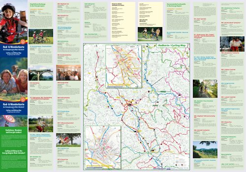
Wanderkarte - Tourismus Energieregion Weiz-St.Ruprecht
Wanderkarte - Tourismus Energieregion Weiz-St.Ruprecht
Wanderkarte - Tourismus Energieregion Weiz-St.Ruprecht

Erfolgreiche ePaper selbst erstellen
Machen Sie aus Ihren PDF Publikationen ein blätterbares Flipbook mit unserer einzigartigen Google optimierten e-Paper Software.
Foto © <strong>St</strong>eiermark <strong>Tourismus</strong><br />
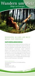
Radfahren, Wandern<br />
und Energie tanken!<br />
Die 17 Gemeinden der <strong>Energieregion</strong> <strong>Weiz</strong>-Gleisdorf, inmitten des stei-<br />
rischen Hügellandes, bestechen nicht nur mit einer faszinierenden Land-<br />
schaft zwischen Thermenland und Almenland und mit einer Vielzahl an<br />
kulturellen Sehenswürdigkeiten und Ausflugszielen, sondern auch mit<br />
kulinarischen Spezialitäten.<br />
Sport- und Freizeitbegeisterte erkunden die Region mit dem Rad entlang<br />
unserer vielen Radrouten oder erleben Naturerlebnisse zu Fuß auf un-<br />
seren unzähligen Wanderwegen. Oasen der Entspannung und Erholung<br />
für den, der Ruhe sucht oder Spaß und Fitness für die ganze Familie - die<br />
<strong>Energieregion</strong> <strong>Weiz</strong>-Gleisdorf bietet für jeden das Richtige. In dieser Kar-<br />
te findet sich nicht nur eine Übersicht über alle Rad- und Wanderwege<br />
sondern auch ein Überblick über die Sehenswürdigkeiten.<br />
Cycling & Hiking in the<br />
Energy Region <strong>Weiz</strong>-Gleisdorf<br />
The 17 municipalities of the “Energy Region <strong>Weiz</strong> – Gleisdorf”, situated in<br />
the middle of the <strong>St</strong>yrian hill country, have not only a fascinating lands-<br />
cape between the „Thermenland“ and the „Almenland“. The Energy Regi-<br />
on <strong>Weiz</strong>-Gleisdorf offers a wide range of cultural sights and destinations<br />
as well a lot of culinary and regional specialities.<br />
Children, teenager, adults and families enjoy the region by cycling along<br />
well-connected cycle paths or experience the nature on foot on our<br />
uncountable hiking trails. Wonderful places for relaxing and recovering<br />
for those people, who are searching for calm and nature or for having<br />
fun combined with fitness for the whole family. The Energy Region <strong>Weiz</strong><br />
– Gleisdorf offers for everybody suitable possibilities. This map gives you<br />
an overview of all cycling and hiking trails and shows you the wonderful<br />
sights of our region.<br />
Raab<br />
Raab<br />
<strong>Weiz</strong>bach<br />
Feistritz<br />
Raab<br />
Rabnitz<br />
Offeneggerbach<br />
Aussichtsturm<br />
Grub<br />
Breitegg<br />
Oberstadl<br />
Untergreith<br />
Hühnerberg<br />
Hummelegg<br />
Albersdorfegg<br />
Hart<br />
b. Eggersdorf<br />
Farcha<br />
Neudorf-<br />
berg<br />
Leiten<br />
Eidexberg<br />
Oberharing<br />
Kalch<br />
Hüttenbüchel<br />
Zeil<br />
Kreil<br />
Külml<br />
Grub<br />
Harterberg<br />
Raas<br />
Nöstlberg<br />
Landscha<br />
Hofmühle<br />
Hühnerberg<br />
Thannhausen<br />
Zettlach<br />
Wieden<br />
Eben<br />
Affental<br />
Birchbaum<br />
Loreto<br />
<strong>St</strong>enzengreith<br />
Breitenfeld<br />
Hof<br />
Hafningberg<br />
Pichl<br />
Unteraich<br />
Lingstätten<br />
Hening<br />
Wetzlberg<br />
Lichtenegg<br />
Reichendorf<br />
Dürrfeistritzgraben<br />
Edlsee<br />
Oberklausen<br />
Kleinpesendorf<br />
Hoferberg<br />
Auerberg<br />
Hinterleiten<br />
Heilbrunn<br />
Sommeralm<br />
Dörfl<br />
Holzhöf<br />
Unterharl<br />
Prebensdorfberg<br />
Kalch<br />
Prebuch<br />
Postelgraben<br />
Brodersdorfberg<br />
Schillingsdorf<br />
Bleihütten<br />
Kreuzberg<br />
Kainberg<br />
Giging<br />
Lembach<br />
Volkersdorf<br />
Wollsdorf<br />
Haselbach<br />
bei <strong>Weiz</strong><br />
Schachen<br />
Pernesreith<br />
Buckenberg<br />
<strong>St</strong>raßhöf<br />
Baumgart<br />
Mauerhöf<br />
Winkelhöf<br />
Hochlangegg<br />
Hart<br />
Wohngraben<br />
Schattauberg<br />
Nitschaberg<br />
Eichgraben<br />
Gamling<br />
Altenberg<br />
Pichlberg<br />
Dietmanns-<br />
dorf<br />
Kotzersdorf<br />
Königgraben<br />
Ebelhof<br />
Willersdorf<br />
Meierhöfen<br />
<strong>St</strong>einberg b. <strong>Weiz</strong><br />
Mortantsch<br />
Grillbichl<br />
<strong>St</strong>urmberg<br />
Gschaid bei <strong>Weiz</strong><br />
Oberaichen<br />
Trog<br />
Eibisberg-Oberegg<br />
<strong>St</strong>eg<br />
<strong>St</strong>. Georgen<br />
Hinterleiten<br />
<strong>St</strong>adt<br />
Feldhöf<br />
Halt<br />
Salchen<br />
Unterlangegg<br />
Breiteben<br />
Baumgarten<br />
Reger-<br />
stätten<br />
Gfang<br />
Unterrossegg<br />
Sandgruben<br />
Hammersberg<br />
Breitenau<br />
Wallhütten<br />
Hart<br />
Seilnergraben<br />
Buchberg<br />
Wölling<br />
Schweinegg<br />
Oberbuchberg<br />
Oberhollerbach<br />
Edelschachen<br />
Baierdorf bei Anger<br />
Dreihöf<br />
Unterharing<br />
Dörfl<br />
Kroisbach<br />
Kaibings-<br />
berg<br />
Rothgmos<br />
Premberg<br />
Marbach<br />
Minireith<br />
Erkgraten<br />
Großglawoggen<br />
Wenisbuch<br />
Mölten<br />
Höf<br />
Anken-<br />
hofen<br />
Haufenreith<br />
<strong>Weiz</strong>eben<br />
Nadisch<br />
Oberrossegg<br />
Koglhof<br />
Rossegg<br />
Wieden<br />
Gschaid<br />
b. Birkfeld<br />
Rabendorf<br />
Sallegg<br />
Oberfeistritz<br />
Oberdorf<br />
Nöstl<br />
Peesen<br />
Alterilz<br />
Krottendorf<br />
Kletten-<br />
dorf<br />
Perndorf<br />
Ilzberg<br />
Elz<br />
Puch b. <strong>Weiz</strong><br />
Siegersdorf<br />
b. Herberstein<br />
Kulming<br />
Rohrbach<br />
Romatschachen<br />
Hirnsdorf<br />
Hartensdorf<br />
Prebensdorf<br />
Großpesendorf<br />
Neudorf<br />
Preßguts<br />
Lohnberg<br />
Rollsdorf<br />
Etzersdorf<br />
Unterfladnitz<br />
Pichl<br />
a.d. Raab<br />
Dörfl<br />
a.d. Raab<br />
<strong>St</strong>. <strong>Ruprecht</strong><br />
a.d. Raab<br />
Mitterdorf<br />
a.d. Raab<br />
Radling<br />
Hafning<br />
Oberdorf<br />
Obergreith<br />
Preding<br />
b. <strong>Weiz</strong><br />
Hofstätten<br />
Klein-<br />
semmering<br />
Gschwendt<br />
Jassing<br />
Pircha<br />
Albersdorf<br />
Nieder-<br />
schöckl<br />
Faßlberg<br />
Fölling<br />
Maria Trost<br />
<strong>St</strong>ifting<br />
Oberschöckl<br />
Rinnegg<br />
Frindorf<br />
Garrach<br />
Fladnitz<br />
a.d. Teichalm<br />
<strong>St</strong>. Kathrein<br />
am Offenegg<br />
Aschau<br />
Fünfing<br />
Wollsdorf<br />
Albersdorf<br />
Plenzengreith<br />
Burgstall<br />
Passail<br />
Arzberg<br />
Anger<br />
Pischelsdorf<br />
i.d.<strong>St</strong>eiermark<br />
Wünschendorf<br />
Wilfersdorf<br />
Brodersdorf<br />
Ludersdorf<br />
Hofstätten<br />
Pirching<br />
a.d. Raab<br />
Pöllau b. Gleisdorf<br />
Untergroßau<br />
Sinabelkirchen<br />
Nitscha<br />
Obernitschaberg<br />
Kühwiesen<br />
Hönigtal<br />
Edelsbach<br />
b. Graz<br />
Höf<br />
Präbach<br />
Pircha<br />
Winterdorf<br />
Leska<br />
Gschaid<br />
Maierhof<br />
Reith<br />
<strong>St</strong>. Johann<br />
b. Herberstein<br />
Sulz b. Gleisdorf<br />
Langegg b. Graz<br />
Nestelbach b. Graz<br />
Autal<br />
Laßnitzhöhe<br />
Hart b. Graz<br />
Kainbach<br />
Prellerberg<br />
Arndorf<br />
Neudorf<br />
Unter-<br />
feistritz<br />
Lebing<br />
<strong>St</strong>ubenberg<br />
am See<br />
Floing<br />
Weinberg<br />
Hart<br />
Göttels-<br />
berg<br />
Krammersdorf<br />
Lam<br />
Hohenau a.d. Raab<br />
Kirchenlee<br />
Naas<br />
Rabnitz<br />
Ebersdorf<br />
Angerer Zeil<br />
Gschnaidt<br />
Parz<br />
Bachl<br />
Grub<br />
Fresen<br />
Schaftalberg<br />
Obergroßau<br />
Wetzawinkel<br />
Arnwiesen<br />
Wetzawinkelberg<br />
Egelsdorf<br />
Flöcking<br />
Hart<br />
WEIZ<br />
Birkfeld<br />
Kumberg<br />
<strong>St</strong>. Radegund<br />
Eggersdorf<br />
Pöllau<br />
GRAZ<br />
GLEISDORF<br />
<strong>St</strong>uben-<br />
bergsee<br />
Edelstockwald<br />
Lushölzer<br />
Ä u ß e r e R a g n i t z<br />
R a s t b i c h l<br />
A u f d e r R i e s<br />
S c h a f t a l<br />
Eidexberg<br />
S a u b e r g<br />
Freiberger Klamm<br />
H i n t e r k u l m<br />
K a g l<br />
H a r t - P u c h<br />
T r e n n s t e i n<br />
F l a d n i t z b e r g<br />
In der Lacken<br />
K l a m m<br />
P o n i g l g r a b e n<br />
Kohlgraben<br />
P a t s c h a b e r g<br />
I n d e r W e i z<br />
G ö s s e n t a l<br />
Schmalzgraben<br />
K a r b e r g<br />
R o s e n b e r g<br />
B ä r e n t a l<br />
H a i d e n h ö f<br />
H ö h e n k o g l<br />
F r e i i n g e r e g g<br />
B u c h e g g<br />
H a s e l b a c h<br />
Königgraben<br />
T r a g b e r g<br />
P u r g s t a l l<br />
b e i E g g e r s d o r f<br />
G a r r a c h e r W a l d<br />
S a t t e l b e r g<br />
U n t e r s a t t e l<br />
W i e d e n b e r g<br />
P o n i g l<br />
V i e r t e l f e i s t r i t z<br />
B a i e r d o r f - U m g e b u n g<br />
R a b e n w a l d<br />
O b e r e r R a b e n w a l d<br />
I n d e r E b e n<br />
A u ß e r f r e s e n<br />
W i n k l B o d e n<br />
O b e r s a i f e n<br />
S a i f e n<br />
K ö p p e l r e i t h<br />
Prätisgraben<br />
O b e r p r ä t i s<br />
J ä g e r l e i t e n<br />
U n t e r e H a s l au<br />
B o d e n w a l d<br />
T e i c h a l m<br />
H i n t e r t o b e r<br />
H a r t e n s t e i n<br />
F u c h s l e i t e n<br />
E g g w a l d<br />
O b e r r e t t e n b a c h<br />
R o h r w e g b e r g<br />
E g e l s d o r f b e r g<br />
N i t s c h a g r a b e n<br />
F r ö s a u<br />
P r ä n t e r<br />
M ü h l b a c h<br />
U n g e r d o r f b e r g<br />
B i t t e r e g g<br />
M e ß l r e i t h<br />
<strong>St</strong> e i n g r a b e n<br />
L a b u c h b e r g<br />
N e s t e l b a c h b e r g<br />
K ö g e l b u c h<br />
O b e r b e r g l e n<br />
O b e r f e l d<br />
B r u c h<br />
K l e e b e r g<br />
Hohenrain<br />
R a b e n w a l d<br />
S o n n l e i t e n<br />
K r i c h l e i t e n<br />
L e c h e n<br />
N a i n ts c h g r a b e n<br />
N a i n t s c h<br />
I m L e h e n<br />
L o c k h ö f<br />
H i n t e r e g g<br />
S c h ö n e g g<br />
V o c k e n b e r g<br />
S o n n l e i t e n<br />
K u l m<br />
R o s e n k o g l<br />
W a l l n e r b e r g<br />
P e ß h a r l<br />
M ü h l w a l d<br />
W o l l s d o r f e r e g g<br />
R a u c h e n b e r g<br />
B a c h b e r g<br />
G r e i t h<br />
G a a s g r a b e n<br />
P a s s a i l e r A l m<br />
S a u g r a b e n<br />
O b e r e H a s l a u<br />
U n t e r p r ä t i s<br />
I n d e r H a i d e<br />
R u b l a n d<br />
V o r d e r k u l m<br />
F r a u e n w a l d<br />
L e h e n b e r g<br />
H o f w a l d<br />
W a l d h o f<br />
F u c h s b e r g<br />
E g l i n s<br />
S o m m e r a l m<br />
Grubbrundl Kpl.<br />
Kleinheilbrunn<br />
Am Sattel<br />
Kapellenfeld<br />
Kogelkpl.<br />
Rotes<br />
Kreuz<br />
R. Alt Schielleiten<br />
R. Neuhaus<br />
Zeilmaxlkreuz<br />
Schl.<br />
Ruine <strong>St</strong>urmberg<br />
<strong>Weiz</strong>klamm<br />
Grasslhöhle<br />
Mühlentalweg<br />
Ruine Trennstein<br />
Ruine Trennstein<br />
Richtstätte Thannhausen<br />
Schl. Külml<br />
<strong>St</strong>. Ulrich<br />
Schl. Herberstein<br />
Schl. Schielleiten<br />
Glockenturm von Nitscha<br />
Schl. Lustbühel<br />
Kirche Maria Trost<br />
Schl. Münichhofen<br />
Golfanlage<br />
Schl. Freiberg<br />
Schaustollen<br />
Windrad<br />
Burg Frondsberg<br />
Bahnmuseum<br />
Sioux City<br />
<strong>St</strong>utenmilchgestüt<br />
Apfelmuseum<br />
Keltenmuseum<br />
Schl. Gutenberg<br />
Raabklamm<br />
Schl. Thannhausen<br />
<strong>Weiz</strong>bergkirche<br />
Schl. Radmannsdorf<br />
Feistritztalbahn<br />
Kirche Breitegg<br />
Ruine <strong>St</strong>urmberg<br />
Schl. <strong>St</strong>adl<br />
Kirche <strong>St</strong>. <strong>Ruprecht</strong><br />
<strong>St</strong>eirische<br />
Apfelstraße<br />
<strong>St</strong>eirische<br />
Apfelstraße<br />
<strong>St</strong>eirische<br />
Apfelstraße<br />
<strong>St</strong>eirische<br />
Apfelstraße<br />
Marienkirche<br />
Friedensgrotte<br />
<strong>St</strong>efaniequelle<br />
Größter Apfel<br />
Kräuteroase<br />
Loretokirche<br />
Katerloch<br />
Hammerwerksmuseum<br />
Taborkirche<br />
Ilzbergkapelle<br />
Hummelmuseum<br />
Bauernmuseum<br />
Franziskus<br />
<strong>St</strong>einbruch<br />
Ruine Waxenegg<br />
Rauchstubenhaus<br />
Sommerrodelbahn<br />
Freizeitpark<br />
Tierpark<br />
<strong>St</strong>ift Pöllau<br />
N a t u r p a r k<br />
P ö l l a u e r t a l<br />
<strong>St</strong>adtpfarrkirche<br />
Wellenbad Refugium<br />
<strong>St</strong>raße der Solarenergie<br />
BMX-Bahn<br />
<strong>St</strong>eirerkraft<br />
Wastlhiasl<br />
Nostalgiebauernhof<br />
Friedlhof<br />
Pirchawald<br />
Raasberg<br />
Osserkogel<br />
Hirschkogel<br />
Hohe Zenz<br />
Pommersberg<br />
Schwarzkogl<br />
Bründlkogel<br />
Buchkogel<br />
Zetz<br />
Rabenwaldkogel<br />
Buchkogel<br />
Kruglhofkogel<br />
Gratwohlkogel<br />
Hundsberg<br />
Wolfsattel<br />
Buchwald<br />
Fresenkogel<br />
Landschakogel<br />
<strong>St</strong>roßberg<br />
Gösser<br />
Rauchenberg<br />
Zwölferkogel<br />
Harl<br />
Burgstaller Höhe<br />
Schachner Kogel<br />
Gollersattel<br />
Büchlberg<br />
Rosenkogel<br />
<strong>St</strong>einberg<br />
Schöcklkopf<br />
Romatschachberg<br />
Weinberg<br />
Kreuzberg<br />
Hauenstein<br />
Hohenberg<br />
Kaiserberg<br />
Hahnkogel<br />
Kleeberg<br />
Gelderkogel<br />
Gaasberg<br />
Fuchskogel<br />
Lauskogel<br />
Heulantsch<br />
Frießenkogel<br />
Mooskogel<br />
Plankogel<br />
<strong>St</strong>reberkogel<br />
Offner Berg<br />
Zoiseleck<br />
Wachholz<br />
Königskogel<br />
Lindkogel<br />
<strong>St</strong>ernbauerkogel<br />
Rabnitzberg<br />
Grubbauerkogel<br />
Nestlbodnerkogel<br />
Osser<br />
Kulmkogel<br />
Feichteck<br />
Schrottenkogel<br />
Buchberg<br />
Feistritz<br />
B72<br />
B72<br />
B72<br />
B64<br />
B64<br />
B65<br />
B65<br />
B54<br />
B54<br />
A2<br />
A2<br />
B72<br />
B72<br />
B65<br />
B64<br />
368<br />
482<br />
357<br />
465<br />
460<br />
414<br />
503<br />
485<br />
386<br />
483<br />
506<br />
455<br />
490<br />
482<br />
504<br />
498<br />
528<br />
427<br />
(405)<br />
404<br />
393<br />
504<br />
526<br />
632<br />
420<br />
521<br />
650<br />
512<br />
655<br />
1009<br />
1103<br />
1024<br />
1264<br />
588<br />
(479)<br />
479<br />
670<br />
954<br />
1048<br />
954<br />
724<br />
818<br />
782<br />
590<br />
653<br />
1287<br />
1124<br />
1122<br />
1030<br />
717<br />
1154<br />
1371<br />
1436<br />
1330<br />
886<br />
992<br />
1223<br />
830<br />
1242<br />
1230<br />
795<br />
879<br />
865<br />
882<br />
1047<br />
913<br />
1274<br />
478<br />
818<br />
663<br />
1280<br />
1090<br />
992<br />
1033<br />
845<br />
774<br />
743<br />
509<br />
576<br />
907<br />
543<br />
782<br />
891<br />
1000<br />
1117<br />
834<br />
666<br />
871<br />
660<br />
703<br />
1271<br />
980<br />
1080<br />
621<br />
757<br />
718<br />
735<br />
857<br />
(653)<br />
726<br />
(694)<br />
650<br />
744<br />
741<br />
628<br />
752<br />
1088<br />
950<br />
864<br />
562<br />
538<br />
751<br />
812<br />
775<br />
618<br />
792<br />
569<br />
823<br />
706<br />
713<br />
565<br />
636<br />
551<br />
852<br />
779<br />
869<br />
678<br />
671<br />
632<br />
808<br />
715<br />
631<br />
(449)<br />
579<br />
649<br />
588<br />
446<br />
532<br />
516<br />
682<br />
525<br />
639<br />
726<br />
609<br />
495<br />
642<br />
1039<br />
1030<br />
(579)<br />
750<br />
1063<br />
628<br />
685<br />
919<br />
1218<br />
1136<br />
751<br />
790<br />
828<br />
633<br />
575<br />
533<br />
536<br />
479<br />
514<br />
490<br />
494<br />
454<br />
442<br />
593<br />
457 531<br />
506<br />
576<br />
975<br />
866<br />
390<br />
421<br />
423<br />
497<br />
409<br />
421<br />
635<br />
532<br />
531<br />
582<br />
493<br />
679<br />
487<br />
624<br />
390<br />
445<br />
414<br />
406<br />
500<br />
610<br />
500<br />
524<br />
554<br />
520<br />
463<br />
503<br />
662<br />
535<br />
672<br />
524<br />
631<br />
704<br />
(720)<br />
761<br />
780<br />
1423<br />
1125<br />
686<br />
672<br />
574<br />
(526)<br />
560<br />
535<br />
542<br />
521<br />
410<br />
462<br />
410<br />
498<br />
504<br />
(378)<br />
366<br />
467<br />
373<br />
362<br />
423<br />
449<br />
421<br />
508<br />
502<br />
425<br />
390<br />
516<br />
447<br />
378<br />
400<br />
408<br />
394<br />
423<br />
394<br />
426<br />
472<br />
588<br />
530<br />
438<br />
502<br />
444<br />
507<br />
529 506<br />
376<br />
471<br />
448<br />
463<br />
509<br />
475<br />
416<br />
404<br />
343<br />
418<br />
417<br />
398<br />
428<br />
445<br />
330<br />
336<br />
426<br />
455<br />
461<br />
470<br />
463<br />
502<br />
375<br />
389<br />
517<br />
426<br />
568<br />
442<br />
545<br />
434<br />
495<br />
487<br />
702<br />
650<br />
517<br />
471<br />
594<br />
575<br />
570<br />
523<br />
416<br />
(410)<br />
397<br />
451<br />
366<br />
498<br />
359<br />
454<br />
422<br />
334<br />
322<br />
419<br />
345<br />
452<br />
410<br />
445<br />
(362)<br />
374<br />
492<br />
491<br />
449<br />
436<br />
577<br />
567<br />
(470)<br />
519<br />
436<br />
511<br />
453<br />
533<br />
466<br />
503<br />
501<br />
535<br />
578<br />
444<br />
563<br />
(560)<br />
547<br />
541<br />
501<br />
416<br />
484<br />
392<br />
420<br />
345<br />
428<br />
454<br />
448<br />
455<br />
343<br />
339<br />
376<br />
460<br />
376<br />
433<br />
462<br />
425<br />
360<br />
464<br />
443<br />
337<br />
418<br />
499<br />
491<br />
486<br />
499<br />
480<br />
499<br />
450<br />
536<br />
509<br />
514<br />
507<br />
411<br />
520<br />
395<br />
479<br />
506<br />
473<br />
1195<br />
978<br />
(970)<br />
956<br />
1022<br />
569<br />
(660)<br />
553<br />
1017<br />
902<br />
1195<br />
1471<br />
1491<br />
1393<br />
1392<br />
1531<br />
1404<br />
1409<br />
1447<br />
1293<br />
642 642<br />
745<br />
1078<br />
966<br />
1030<br />
1276<br />
1132<br />
1032<br />
1246<br />
1225<br />
1007<br />
955<br />
723<br />
927<br />
1078<br />
583<br />
741<br />
731<br />
589<br />
834<br />
789<br />
807<br />
670<br />
707<br />
770<br />
915<br />
560<br />
412<br />
335<br />
323<br />
382<br />
323<br />
314<br />
331<br />
466<br />
717<br />
979<br />
1029<br />
1142<br />
1076<br />
1424<br />
1548<br />
1410<br />
1356<br />
1242<br />
1186<br />
705<br />
483<br />
476<br />
557<br />
473<br />
548<br />
499<br />
901<br />
840<br />
998<br />
1046<br />
686<br />
703<br />
702<br />
647<br />
502<br />
444<br />
489<br />
482<br />
496<br />
584<br />
460<br />
607<br />
632<br />
436<br />
696<br />
574<br />
793<br />
804<br />
629<br />
982<br />
847<br />
777<br />
641<br />
524<br />
807<br />
636<br />
738<br />
866<br />
(425)<br />
721<br />
754<br />
694<br />
883<br />
766<br />
592<br />
833<br />
869<br />
1101<br />
606<br />
400<br />
535<br />
585<br />
394<br />
364<br />
436<br />
357<br />
355<br />
344<br />
358<br />
413<br />
419<br />
345<br />
392<br />
345<br />
406<br />
405<br />
433<br />
339<br />
427<br />
315<br />
392<br />
400<br />
369<br />
413<br />
436<br />
511<br />
536<br />
417<br />
486<br />
445<br />
481<br />
412<br />
408<br />
521<br />
512<br />
442<br />
564<br />
460<br />
910<br />
744<br />
682<br />
744<br />
1043<br />
928<br />
737<br />
592<br />
597<br />
676<br />
970<br />
938<br />
700<br />
783<br />
754<br />
810<br />
1237<br />
1198<br />
1253<br />
1367<br />
456<br />
456<br />
457<br />
481<br />
619<br />
465<br />
435<br />
394<br />
502<br />
461<br />
409<br />
418<br />
444<br />
450<br />
443<br />
520<br />
561<br />
523<br />
446<br />
467<br />
524<br />
537<br />
437<br />
582<br />
504<br />
474<br />
520<br />
679<br />
690<br />
663<br />
593<br />
578<br />
511<br />
711<br />
419<br />
392<br />
587<br />
Schl. Thannhausen<br />
<strong>Weiz</strong>bergkirche<br />
Feistritztalbahn<br />
Kirche Breitegg<br />
Schl. <strong>St</strong>adl<br />
Kirche <strong>St</strong>. <strong>Ruprecht</strong><br />
Schl. Gutenberg<br />
Raabklamm<br />
Ruine <strong>St</strong>urmberg<br />
WZ12<br />
WZ11<br />
WZ11<br />
WZ10<br />
WZ10<br />
WZ12<br />
WZ11<br />
WZ11<br />
WZ10<br />
WZ10<br />
WZ10<br />
WZ4<br />
WZ3<br />
WZ3<br />
WZ10<br />
WZ10<br />
Kilometer<br />
0 1 2 3<br />
Recommended cycle paths<br />
in the Energy Region<br />
„FunErgyTour“ − Loop Route<br />
Level of difficulty easy<br />
Markings perfect<br />
Course & distance <strong>Weiz</strong> − <strong>St</strong>. <strong>Ruprecht</strong> − Gleisdorf − Nitscha<br />
− Krottendorf − <strong>Weiz</strong> (38 km)<br />
Characteristics<br />
<strong>St</strong>arting off in the energy town of <strong>Weiz</strong> and going on to the sun-<br />
ny town of Gleisdorf along the Raabtal cycle path R11 and then<br />
back via the WZ 10 past traditional Austrian restaurants serving<br />
wine and home-made foods and the <strong>St</strong>yrian "Apple Road”. There<br />
are many attractions to be enjoyed along the route. Radmannsdorf<br />
Castle, <strong>Weiz</strong>er Kunsthaus, Gemini House, impressive areas of natural<br />
beauty along the Bärental valley, Friedensgrotte (peace grotto) and<br />
Foucault’s Pendulum in <strong>St</strong>. <strong>Ruprecht</strong>, <strong>St</strong>reet of Solar Energy in Gleis-<br />
dorf, the wine-growing community of Nitscha, the Garden of Gene-<br />
rations in Krottendorf and the Spiritual Walk between Tabor Church<br />
and <strong>Weiz</strong>berg Church. And you can cool off in the swimming pools<br />
in <strong>Weiz</strong>, <strong>St</strong>. <strong>Ruprecht</strong> or Gleisdorf. Cycling inns and traditional Austri-<br />
an restaurants serving wine and home-made foods would be hap-<br />
py to welcome cyclists for refreshments, culinary delights or even<br />
help them out in case of any mishaps. Altitude: 435 m or 504 m.<br />
R8 „Feistritztal“ Cycle Path − <strong>St</strong>eam and<br />
Pedals<br />
Level of difficulty easy<br />
Markings perfect<br />
Course & distance Ratten − 18 km − Birkfeld − 12 km (with<br />
steam train) − Anger − 14 km<br />
− <strong>St</strong>ubenberg am See − 6 km<br />
− <strong>St</strong>. Johann bei Herberstein − 22 km<br />
− Fürstenfeld (48 km)<br />
Characteristics<br />
You have got a lot to look forward to on the Feistritz cycle path even<br />
before putting one foot in the pedals. On the outward or return<br />
journey to or from Birkfeld you should definitely treat yourself to<br />
a ride on the steam train from <strong>Weiz</strong>. It’s the best way of gaining a<br />
fantastic impression of the wildly romantic and incredibly natural-<br />
looking landscape passing you by. And there’s still lots to discover:<br />
from the mine in Ratten, the summer tobogganing adventure run in<br />
Koglhof, the Sioux City in Anger (Mondays) right up to the <strong>St</strong>uben-<br />
bergsee lake, and the zoo and castle at Herberstein.<br />
R10 „Ilztal“ Cycle Path<br />
Level of difficulty moderate<br />
Markings perfect<br />
Course & distance <strong>Weiz</strong> − 13 km − Prebuch − 4 km − Groß-<br />
pesendorf − 10 km − Sinabelkirchen<br />
− 10 km − Fürstenfeld (37 km)<br />
Characteristics:<br />
The Ilztal cycling path begins in the <strong>Weiz</strong>tal valley and ends in the<br />
Feistritztal valley. This worthwhile trip takes you through the Mühl-<br />
wald, an approx. 500 m high ridge, which separates <strong>Weiz</strong> and the<br />
Ilztal valley. The attractive Kernkapelle Chapel is found on the “<strong>St</strong>ein-<br />
bauernhöhe” rise. A rapid 4 km descent then takes you from Pre-<br />
buch to Großpesendorf (160 metres in altitude).<br />
R11 „Raabursprung − <strong>Weiz</strong> − Raabtal“<br />
Cycle Path − from the Almenland to the<br />
Energy Region<br />
Level of difficulty moderate<br />
Markings perfect<br />
Course & distance Raabursprung − 8 km − Passail − 20 km<br />
− <strong>Weiz</strong> (28 km)<br />
Characteristics<br />
From the impressive tranquillity of the Raabquelle spring, this cyc-<br />
ling path takes you to <strong>Weiz</strong>, the town which is full of energy with<br />
its many sights like the Tabor Church, <strong>Weiz</strong>berg Church, Kunsthaus,<br />
Gemini House, etc. On your way you’ll find the Arzberg show mine,<br />
Grasslhöhle cave and Katerloch (the show cave with the most sta-<br />
lagmites and stalactites in the whole of Austria! It is necessary to<br />
make an appointment by phone in order to view the cave) Sights<br />
that really should be seen! Cycling inns in the Raabtal valley are hap-<br />
py to welcome cyclists for refreshments, culinary delights or even<br />
help them out in case of any mishaps during the whole of the cyc-<br />
ling season. The cycle path runs at an altitude of 1075 m or 479 m<br />
R11 „<strong>Weiz</strong> − Fehring − Raabtal“ Cycle<br />
Path − From the Energy Region to the Spa<br />
Region „Thermenland”<br />
Level of difficulty easy<br />
Markings perfect<br />
Course & distance <strong>Weiz</strong> − 9 km − <strong>St</strong>. <strong>Ruprecht</strong> / Raab<br />
− 8 km − Gleisdorf − 9 km − <strong>St</strong>. Magarethen<br />
/ Raab − 50 km − Fehring (76 km)<br />
Characteristics<br />
This route is extremely family-friendly. There are numerous places<br />
of excursion along the route including the church and peace grotto<br />
(Friedensgrotte) in <strong>St</strong>. <strong>Ruprecht</strong>, the parish church and solar tree in<br />
Gleisdorf as well as the World Machine (Weltmaschine), bridge mu-<br />
seum and even a chocolate making factory. The cycling pass from<br />
the Raabtal valley cycling inns even doubles up as free entrance to<br />
the Loipersdorf spa! The outward or return journey from Jenners-<br />
dorf to <strong>Weiz</strong> is great on the train, too! Trains run by the Austrian<br />
Federal Railway run on the Graz – Gleisdorf – Feldbach – Fehring<br />
– Jennersdorf – Szentgotthárd (Hungary) route. Regional trains run<br />
between Gleisdorf and <strong>Weiz</strong>, and also to and from Graz on week-<br />
days. Altitude: 479 m or 272 m.<br />
WZ1 „Kulmblick“ (View of the Kulm)<br />
Cycling Tour<br />
Level of difficulty challenging<br />
Markings perfect<br />
Course & distance Pischelsdorf − 6 km − Reichendorf − 13 km<br />
− Etzersdorf − 8 km − Prebuch − 8 km<br />
− Pischelsdorf (35 km)<br />
Characteristics<br />
This pleasure tour passes many orchards and takes you along part<br />
of the apple road past many traditional Austrian restaurants serving<br />
wine and home-made foods (Buschenschank)<br />
This cycling path runs at an altitude of between 343 and 498 m.<br />
WZ2 „Hügelland“ (Hill Country) Cycling<br />
Tour<br />
Level of difficulty moderate<br />
Markings perfect<br />
Course & distance Pischelsdorf- 9 km- Prebensdorf- and<br />
back to Pischelsdorf (18 km)<br />
Characteristics<br />
This is an extremely wooded cycle path, which also takes you<br />
through Pischelsdorf where the highest church spire in eastern <strong>St</strong>y-<br />
ria is located. This cycling path runs at an altitude of between 330<br />
and 433 m.<br />
WZ3 „Hartwald“ Cycling Tour<br />
Level of difficulty moderate<br />
Markings perfect<br />
Course & distance Nitscha − 6 km − Untergroßau − 11 km<br />
− Nitscha (17 km)<br />
Characteristics<br />
A somewhat shorter route, this cycling tour takes you past many<br />
extremely inviting, traditional Austrian restaurants serving fantastic<br />
wine and hearty home-made snacks.<br />
This cycling path runs at an altitude of between 315 and 426 m.<br />
WZ4 Connection Cycle Path – Connection<br />
to „Gleisdorf“<br />
Level of difficulty easy<br />
Markings perfect<br />
Course & distance Nitscha − 5 km − Gleisdorf (5 km)<br />
Characteristics<br />
Connects the cycle paths WZ3, WZ14 and WZ10 to Gleisdorf, where<br />
the solar tree, parish church and gastronomy highlights on the main<br />
square are perfect for a visit. This cycling path runs at an altitude of<br />
between 362 and 440 m.<br />
WZ6 „Kulmkriterium“ Cycling Tour<br />
Level of difficulty challenging<br />
Markings perfect<br />
Course & distance Pischelsdorf − 7 km − Kulming − 4 km<br />
− Kulmwirt (11 km)<br />
Characteristics<br />
A route for more experienced cyclists beginning on a more flat<br />
section along orchards past the Celtic museum and then up to the<br />
crest of the Kulm mountain where you can take pleasure in enjoying<br />
the fantastic view in all directions (<strong>St</strong>ubenbergsee lake, Anger, <strong>Weiz</strong>,<br />
Pischelsdorf, …). This cycling path runs at an altitude of between<br />
378 and 975 m.<br />
WZ7 „Buschenschank“ Cycling Tour*<br />
Level of difficulty moderate<br />
Markings perfect<br />
Course & distance Pischelsdorf − 3 km − Romatschachen<br />
− 8 km − Pischelsdorf (11 km)<br />
Characteristics<br />
This cycling path runs at an altitude of between 378 and 500 m.<br />
The TOP Buschenschank (traditional Austrian restaurants serving<br />
wine and home-made foods) cycling tour which doesn't really need<br />
any further explanation.<br />
* Buschenschank: Traditional Austrian restaurant serving wine and<br />
home-made foods<br />
WZ8 „Energieachter” Cycling Tour<br />
Level of difficulty moderate<br />
Markings perfect<br />
Course & distance in and about <strong>Weiz</strong><br />
Characteristics<br />
This is the cycle path in and about <strong>Weiz</strong> focussing on the topic of<br />
energy and innovation. Along the route is the Kunsthaus, Archi-<br />
medes wheel, solar sail of the Pichlerwerke, W.E.I.Z − <strong>Weiz</strong> Energy<br />
Innovation Centre, Radmannsdorf Castle, Tabor Church, <strong>Weiz</strong>berg<br />
Church, the spiritual path and the Gemini House solar power plant<br />
/ inhabited power plant. WZ8 also guarantees a fantastic view of<br />
<strong>Weiz</strong>, the town full of energy! This cycling path runs at an altitude of<br />
between 456 and 536 m.<br />
WZ9 „Freiberg“ Cycle Path<br />
Level of difficulty moderate<br />
Markings perfect<br />
Course & distance <strong>St</strong>. <strong>Ruprecht</strong>/Raab − 8 km − Gleisdorf /<br />
Ludersdorf (8 km)<br />
Characteristics<br />
The WZ9 cycle path is the No. 1 cycle path for recharging your batteries,<br />
which takes you past the golf course and on to Freiberg Castle, which is<br />
perfect for a short stop-off. There are many opportunities of combining<br />
this cycle path with other paths i.e. with R11 on the return journey. This<br />
cycling path runs at an altitude of between 375 and 465 m.<br />
WZ10 Energy Cycle Path<br />
Level of difficulty easy<br />
Markings perfect<br />
Course & distance <strong>Weiz</strong> − 13 km − Prebuch − 13 km<br />
− Hofstätten (26 km)<br />
Characteristics<br />
The WZ10 is the “pleasure tour” of the energy region passing by<br />
many orchards and many traditional Austrian restaurants serving<br />
wine and home-made foods (Buschenschank), the apple castle<br />
(“Apfelschlössl”) and taking you along the apple road. This cycling<br />
path runs at an altitude of between 339 and 509 m.<br />
WZ11 „Labuch“ Cycle Path<br />
Level of difficulty moderate<br />
Markings perfect<br />
Course & distance Gleisdorf − 10 km − Hart − 7 km − Sulz<br />
bei Gleisdorf (17 km)<br />
Characteristics<br />
WZ11 is a cycle path loop in the hill country southwest of Gleisdorf.<br />
The panorama look-out on the Kleeberg mountain is well worth a<br />
visit. This cycling path runs at an altitude of between 339 and 499 m.<br />
WZ12 „Apfelland“ (Apple Country)<br />
Cycling Tour<br />
Level of difficulty easy<br />
Markings perfect<br />
Course & distance Anger − 3 km − Oberfeistritz (3 km)<br />
Characteristics<br />
The WZ12, the cycle path around and through Anger takes you past Si-<br />
oux City and to the Töchterle Hof mare’s milk stables along the Feistritz<br />
River. This cycling path runs at an altitude of between 435 and 479 m.<br />
WZ14 Vitamin Tour<br />
Level of difficulty easy<br />
Markings perfect<br />
Course & distance Tieberhof − 7 km − Nitscha − 4 km<br />
− Arnwiesen − 2 km − Pirching (13 km)<br />
Characteristics<br />
Past the marked stalls of the direct sellers, wine-growers /home-made<br />
food producers and farmers on the WZ14 through fantastic landscapes<br />
with breathtaking views, the WZ14 cycling tour can be easily linked with<br />
the R11 and WZ10 tours. Cyclists from the area around <strong>Weiz</strong> especially<br />
use the R11-WZ14 – WZ10 cycle loop or vice versa for Sunday excursi-<br />
ons. The cycle path runs at an altitude of between 362 and 252 m.<br />
Radl (Cycling) Trekking Tour<br />
Level of difficulty challenging<br />
Markings perfect<br />
Course & distance Graz − Hönigtal − 17 km − Gleisdorf − 7 km<br />
<strong>St</strong>. <strong>Ruprecht</strong>/Raab − 7 km − Etzersdorf<br />
− 7 km Puch / <strong>Weiz</strong> − 11 km − <strong>St</strong>ubenberg<br />
am See (49 km) – on to Hartberg<br />
Characteristics<br />
The eastern <strong>St</strong>yrian cycling tour for experienced cyclists, which takes<br />
us through a fantastic landscape, partly along the Apple Road with<br />
traditional Austrian restaurants serving wine and home-made foods<br />
and boasting show distilleries and fruit growers, who offer products<br />
of both the fresh and liquid variety and then it’s on to <strong>St</strong>ubenberg<br />
where <strong>St</strong>ubenberg lake and the zoo and castle in Herberstein are<br />
fantastic to stay a while before making your way on to Hartberg.<br />
Alpine Cycling Tour<br />
Level of difficulty Cycling route (see www.alpentour.at)<br />
Markings perfect<br />
Course & distance Graz − Schöckl − 15 km − Arzberg − 6 km<br />
− Passail − 13 km − <strong>St</strong> Kathrein/Offenegg<br />
− 22 km − Birkfeld − 23 km − Pöllau − 27 km<br />
− Miesenbach (106 km) – on to Fischbach<br />
„<strong>Weiz</strong> – Puch“ (via Pichl) in the planning<br />
The Puch-<strong>Weiz</strong> connection path winds its way along the „<strong>St</strong>yrian<br />
Apple Road“ cycling past old traditional farmhouses and through<br />
tranquil villages and leafy green forests.<br />
Empfohlene Radwege<br />
in der <strong>Energieregion</strong><br />
FunErgyTour − Rundtour<br />
Schwierigkeitsgrad einfach<br />
Markierung optimal<br />
Verlauf/Länge <strong>Weiz</strong> − <strong>St</strong>. <strong>Ruprecht</strong> − Gleisdorf<br />
− Nitscha − Krottendorf − <strong>Weiz</strong> (38 km)<br />
Beschreibung<br />
Von der Energiestadt <strong>Weiz</strong> bis in die Sonnenstadt Gleisdorf geht’s<br />
am Raabtalradweg R11 entlang und retour über den WZ 10 vor-<br />
bei an Buschenschänken und der Apfelstraße. Viele Attraktivitäten<br />
befinden sich an der <strong>St</strong>recke: Schloss Radmannsdorf, <strong>Weiz</strong>er Kunst-<br />
haus, Gemini Haus, beeindruckendes Naturerlebnis entlang des<br />
Bärentals, Friedensgrotte und Foucaultsches Pendel in <strong>St</strong>. <strong>Ruprecht</strong>,<br />
<strong>St</strong>raße der Solarenergie in Gleisdorf, die Weinbaugemeinde Nitscha,<br />
der Garten der Generationen in Krottendorf und der Spirituelle Weg<br />
zwischen Taborkirche und <strong>Weiz</strong>bergkirche. Abkühlung finden Sie<br />
im <strong>Weiz</strong>er, <strong>St</strong>. <strong>Ruprecht</strong>er oder im Gleisdorfer Schwimmbad. Radl-<br />
wirte und Buschenschänke helfen bei Hunger, Durst und kleinen<br />
Pannen gerne weiter. Höhenmeter: 435 m bzw. 504 m<br />
R8 Feistritztalradweg − Dampf und Pedale<br />
Schwierigkeitsgrad einfach<br />
Markierung optimal<br />
Verlauf/Länge Ratten − 18 km − Birkfeld − 12 km (mit<br />
Dampfbummelzug) − Anger – 14 km<br />
− <strong>St</strong>ubenberg am See − 6 km − <strong>St</strong>. Johann/<br />
Herberstein − 22 km − Fürstenfeld (72 km)<br />
Beschreibung<br />
Auf eines kann man sich beim Feistritztalradweg schon vor dem<br />
ersten Tritt ins Pedal freuen: Auf die Hin- beziehungsweise Rückrei-<br />
se nach und von Birkfeld, die sollte man sich nämlich unbedingt<br />
mit dem Dampfbummelzug von <strong>Weiz</strong> aus gönnen. Den Fahrplan<br />
findet man unter www.feistritztalbahn.at. Da bekommt man einen<br />
ersten Eindruck davon, wie naturbelassen und wildromantisch die<br />
vor einem liegende Landschaft noch ist. Dabei gibt es auch vieles<br />
zu entdecken: vom Bergbau in Ratten über die Sommerrodelbahn<br />
in Koglhof, die Sioux City in Anger bis zum <strong>St</strong>ubenbergsee, Tierpark<br />
und Schloss Herberstein.<br />
R10 Ilztalradweg<br />
Schwierigkeitsgrad mittel<br />
Markierung optimal<br />
Verlauf/Länge <strong>Weiz</strong> − 13 km − Prebuch − 4 km − Groß-<br />
pesendorf − 10 km − Sinabelkirchen<br />
− 10 km − Fürstenfeld (37 km)<br />
Beschreibung<br />
Der Ilztal-Radweg beginnt im <strong>Weiz</strong>tal und endet im Feistritztal. Die<br />
erlebenswerte Fahrt führt durch den Mühlwald, einem rund 500 m<br />
hohen Bergrücken, der <strong>Weiz</strong> und das Ilztal trennt. Auf der <strong>St</strong>einbau-<br />
ernhöhe steht die fotogene Kernkapelle. Von Prebuch erfolgt eine<br />
4 km lange flotte Abfahrt nach Großpesendorf (160 Höhenmeter).<br />
R11 Raabursprung – <strong>Weiz</strong> – Raabtalradweg<br />
– vom Almenland in die <strong>Energieregion</strong><br />
Schwierigkeitsgrad mittel<br />
Markierung optimal<br />
Verlauf/Länge Raabursprung − 8 km − Passail − 20 km<br />
− <strong>Weiz</strong> (28 km)<br />
Beschreibung<br />
Von der beeindruckenden <strong>St</strong>ille der Raabquelle führt dieser Radweg<br />
nach <strong>Weiz</strong>, der <strong>St</strong>adt voll Energie mit ihren zahlreichen Sehenswür-<br />
digkeiten wie Taborkirche, <strong>Weiz</strong>bergkirche, Kunsthaus, Geminihaus,<br />
usw. Unterwegs befinden sich mit dem Schaubergwerk Arzberg,<br />
der Grasslhöhle und dem Katerloch (tropfsteinreichste Schauhöhle<br />
Österreichs! Tel. Anmeldung in beiden Höhlen erforderlich.). Aus-<br />
flugsziele, die man besuchen sollte. Während der gesamten Rad-<br />
saison helfen die Raabtal − Radlwirte bei Hunger und Durst sowie<br />
kleinen Pannen gerne weiter. Der Radweg verläuft auf einer Höhe<br />
von 1075 m bzw. 479 m.<br />
R11 <strong>Weiz</strong> − Fehring − Raabtalradweg −<br />
von der <strong>Energieregion</strong> ins Thermenland<br />
Schwierigkeitsgrad einfach<br />
Markierung optimal<br />
Verlauf/Länge <strong>Weiz</strong> − 9 km − <strong>St</strong>. <strong>Ruprecht</strong>/Raab<br />
− 8 km − Gleisdorf − 9 km − <strong>St</strong>. Mar-<br />
garethen/Raab − 50 km − Fehring (76 km)<br />
Beschreibung<br />
Dieser Abschnitt ist sehr familienfreundlich. Entlang der <strong>St</strong>recke gibt<br />
es mit Kirche und Friedensgrotte in <strong>St</strong>. <strong>Ruprecht</strong>, <strong>St</strong>adtpfarrkirche<br />
und Solarbaum in Gleisdorf sowie Weltmaschine, Brückenmuseum<br />
und einer Schokoladenmanufaktur zahlreiche Ausflugsziele. Der<br />
<strong>St</strong>empelpass der Raabtal – Radwirte wird sogar zur Eintrittskarte in<br />
die Therme Loipersdorf!<br />
Die An- bzw. Rückreise von Jennersdorf nach <strong>Weiz</strong> funktioniert gut<br />
mit dem Zug! ÖBB-Züge verkehren auf der <strong>St</strong>recke Graz – Gleisdorf<br />
– Feldbach – Fehring – Jennersdorf – Szentgotthárd (Ungarn). Lan-<br />
desbahn-Züge verkehren zwischen Gleisdorf und <strong>Weiz</strong>, an Werkta-<br />
gen auch ab/bis Graz. Höhenmeter: 479 m bzw. 272 m.<br />
WZ1 Kulmblick- Tour<br />
Schwierigkeitsgrad schwer<br />
Markierung optimal<br />
Verlauf/Länge Pischelsdorf − 6 km − Reichendorf<br />
− 13 km − Etzersdorf − 8 km − Prebuch<br />
− 8 km − Pischelsdorf (35 km)<br />
Beschreibung<br />
Die „Genuss-<strong>St</strong>recke“ entlang vieler Obstanlagen und einem Teil der<br />
Apfelstraße vorbei an vielen Buschenschänken. Der Radweg ver-<br />
läuft auf einer Höhe zw. 343 und 498 m<br />
WZ2 Hügelland- Tour<br />
Schwierigkeitsgrad mittel<br />
Markierung optimal<br />
Verlauf/Länge Pischelsdorf − 9 km- Prebensdorf<br />
− und zurück nach Pischelsdorf (18 km)<br />
Beschreibung<br />
Ein sehr waldreicher Radweg, der auch durch Pischelsdorf und so-<br />
mit zum höchsten Kirchturm der Oststeiermark führt. Der Radweg<br />
verläuft auf einer Höhe zw. 330 und 433 m<br />
WZ3 Hartwald- Tour<br />
Schwierigkeitsgrad mittel<br />
Markierung optimal<br />
Verlauf/Länge Nitscha − 6 km − Untergroßau − 11 km<br />
− Nitscha (17 km)<br />
Beschreibung<br />
Eine eher kurze Runde, an der zahlreiche Buschenschänke zu einer<br />
Jause und einem Glas Wein einladen. Der Radweg verläuft auf einer<br />
Höhe zw. 315 und 426 m<br />
WZ4 Verbindungsradweg –<br />
Anschluss nach Gleisdorf<br />
Schwierigkeitsgrad einfach<br />
Markierung optimal<br />
Verlauf/Länge Nitscha − 5 km − Gleisdorf (5 km)<br />
Beschreibung<br />
Verbindet die Radwege WZ3, WZ14 und WZ10 mit Gleisdorf. Hier<br />
laden der Solarbaum, die <strong>St</strong>adtpfarrkirche und die Gastronomie<br />
am Hauptplatz zu einem Besuch ein. Der Radweg verläuft auf einer<br />
Höhe zw. 362 und 440 m<br />
WZ6 Kulmkriterium<br />
Schwierigkeitsgrad schwer<br />
Markierung optimal<br />
Verlauf/Länge Pischelsdorf − 7 km − Kulming<br />
− 4 km − Kulmwirt (11 km)<br />
Beschreibung<br />
Eine <strong>St</strong>recke für geübte Radfahrer, beginnend noch eher flach ent-<br />
lang von Obstanlagen, vorbei am Keltenmuseum und dann bergauf<br />
bis zum Kulmgipfel, von wo man einen herrlichen Ausblick in alle<br />
Richtungen (<strong>St</strong>ubenbergsee, Anger, <strong>Weiz</strong>, Pischelsdorf, …) genie-<br />
ßen kann. Der Radweg verläuft auf einer Höhe zw. 378 und 975 m<br />
WZ7 Buschenschank Tour<br />
Schwierigkeitsgrad mittel<br />
Markierung optimal<br />
Verlauf/Länge Pischelsdorf − 3 km − Romatschachen<br />
− 8 km − Pischelsdorf (11 km)<br />
Beschreibung<br />
Der Radweg verläuft auf einer Höhe zw. 378 und 500 m „Die“ Bu-<br />
schenschanktour der Oststeiermark, auf jede weitere Erklärung<br />
kann verzichtet werden.<br />
WZ8 Energie-Achter<br />
Schwierigkeitsgrad mittel<br />
Markierung optimal<br />
Verlauf/Länge in und um <strong>Weiz</strong><br />
Beschreibung<br />
Der Radweg in und um <strong>Weiz</strong> zum Thema Energie und Innovation.<br />
Entlang der <strong>St</strong>recke befinden sich Kunsthaus, Archimedesrad, das<br />
Sonnensegel der Pichlerwerke, <strong>Weiz</strong>er-Energie-Innovations-Zentrum,<br />
Schloß Radmannsdorf, Taborkirche, <strong>Weiz</strong>bergkirche, der spirituelle<br />
Weg und das Sonne/Wohnkraftwerk Geminihaus. Der WZ8 garantiert<br />
nebenbei auch einen herrlichen Blick auf <strong>Weiz</strong>, der <strong>St</strong>adt voll Energie!<br />
Der Radweg verläuft auf einer Höhe zw. 456 und 536 m.<br />
WZ9 Freiberg-Radweg<br />
Schwierigkeitsgrad mittel<br />
Markierung optimal<br />
Verlauf/Länge <strong>St</strong>. <strong>Ruprecht</strong>/Raab − 8 km − Gleisdorf<br />
− Ludersdorf (8 km)<br />
Beschreibung<br />
Der WZ9, „der“ Radweg zum Energietanken führt vorbei an der Gol-<br />
fanlage und am Schloß Freiberg und lädt dort zu einer kurzen Rast<br />
ein. Es gibt viele Möglichkeiten, ihn mit anderen Radwegen zu kom-<br />
binieren z. B. auf der Rückfahrt mit dem R11. Der Radweg verläuft<br />
auf einer Höhe zw. 375 und 465 m.<br />
WZ10 Energieradweg<br />
Schwierigkeitsgrad einfach<br />
Markierung optimal<br />
Verlauf/Länge <strong>Weiz</strong> − 13 km − Prebuch − 13 km<br />
− Hofstätten (26 km)<br />
Beschreibung<br />
Der WZ10 ist „die“ Genusstour der <strong>Energieregion</strong> vorbei an vielen<br />
Obstanlagen, Buschenschänken, am Apfelschlössl und an der Apfel-<br />
straße. Der Radweg verläuft auf einer Höhe zw. 339 und 509 m.<br />
WZ11 Höhenrundweg Labuch<br />
Schwierigkeitsgrad mittel<br />
Markierung optimal<br />
Verlauf/Länge Gleisdorf − 10 km − Hart − 7 km<br />
− Sulz bei Gleisdorf (17 km)<br />
Beschreibung<br />
Der WZ11 ist ein Höhenrundweg im Hügelland südwestlich von<br />
Gleisdorf, die Aussichtswarte am Kleeberg lädt zu einem Aufenthalt<br />
ein. Der Radweg verläuft auf einer Höhe zw. 339 und 499 m.<br />
WZ12 Apfelland-Tour<br />
Schwierigkeitsgrad einfach<br />
Markierung optimal<br />
km Anger − 3 km − Oberfeistritz (3 km)<br />
Beschreibung<br />
Der WZ12, der Radweg um und durch Anger verläuft vorbei an der Si-<br />
oux City und am <strong>St</strong>utenmilchgestüt Töchtelehof entlang der Feistritz.<br />
Der Radweg verläuft auf einer Höhe zw. 435 und 479 m<br />
WZ14 Vitamin-Tour<br />
Schwierigkeitsgrad mittel<br />
Markierung optimal<br />
Km Tiebersdorf − 7 km − Nitscha − 4 km<br />
− Arnwiesen − 2 km − Hartl (13 km)<br />
Beschreibung<br />
Die Vitamintour in hügeliger Natur vorbei an Direktvermarktern wie z.B. dem<br />
Fruchtsafthof Weigl. Der Radweg verläuft auf einer Höhe zw. 362 und 452 m<br />
Radl-Trekking-Tour<br />
Schwierigkeitsgrad schwer<br />
Markierung optimal<br />
Verlauf/Länge Graz − Hönigtal − 17 km − Gleisdorf<br />
− 7 km − <strong>St</strong>. <strong>Ruprecht</strong>/Raab − 7 km −<br />
− Etzersdorf − 7 km − Puch/<strong>Weiz</strong> − 11 km<br />
− <strong>St</strong>ubenberg am See − (49 km) weiter<br />
nach Hartberg<br />
Beschreibung<br />
Die oststeirische Tour für geübte Radfahrer führt durch eine wun-<br />
derschöne Landschaft, teilweise entlang der Apfelstraße mit Bu-<br />
schenschänken, Schaubrennereien und Obstbauern, die ihre Pro-<br />
dukte in frischer und auch flüssiger Form anbieten und geht dann<br />
weiter nach <strong>St</strong>ubenberg, wo See, Tierpark und Schloss Herberstein<br />
zum Verweilen einladen, bevor man sich auf den Weg nach Hart-<br />
berg macht.<br />
Alpentour<br />
Schwierigkeitsgrad Bikerstrecke<br />
(siehe www.alpentour.at)<br />
Markierung optimal<br />
Verlauf/Länge Graz − Schöckl − 15 km − Arzberg<br />
− 6 km − Passail − 13 km − <strong>St</strong>. Kathrein/<br />
Offenegg − 22 km − Birkfeld − 23 km<br />
− Pöllau − 27 km − Miesenbach (106 km)<br />
− weiter nach Fischbach<br />
<strong>Weiz</strong> − Puch (über Pichl) in Planung<br />
Durch stille Dörfer und lauschige Wälder, vorbei an alten, stil-<br />
vollen Bauernhöfen schlängelt sich der Verbindungsweg Puch-<br />
<strong>Weiz</strong> entlang der „<strong>St</strong>eirische Apfelstraße“.<br />
Radservice <strong>St</strong>ellen<br />
Cycling Service Centres<br />
Zweirad Neffe<br />
8200 Gleisdorf, Grazer <strong>St</strong>raße 3<br />
Tel. 03112/2313-0<br />
Laller Zweirad<br />
8200 Gleisdorf, Franz Josef <strong>St</strong>raße 21<br />
Tel. 03112/2411<br />
Intersport Pilz<br />
8200 Gleisdorf, Bürgergasse 19<br />
Tel. 03112/2389<br />
Garten - Hoteldorf Ochensberger<br />
8181 <strong>St</strong>. <strong>Ruprecht</strong>/R. 181<br />
Tel. 03178/51320<br />
Gasthof Hotel Locker<br />
8181 <strong>St</strong>. <strong>Ruprecht</strong>/R. 29<br />
Tel. 03178/2310<br />
Intersport XL<br />
8160 <strong>Weiz</strong>, Kapruner Generatorstr. 5<br />
Tel. 03172/2715<br />
Biker´s Shop Landring <strong>Weiz</strong><br />
8160 <strong>Weiz</strong>, Gleisdorferstraße 111<br />
Tel. 03172/2501- 364<br />
Autohaus <strong>Weiz</strong> Ges.m.b.H. & Co KG, VW Audi<br />
8160 <strong>Weiz</strong>, Werkweg 10-12<br />
Tel. 03172/3555<br />
Kilometer<br />
Sport 2000<br />
8160 <strong>Weiz</strong>, Birkfelderstr. 40<br />
Tel. 03172/2417-0<br />
Autohaus Kreimer, Skoda Händler<br />
8160 <strong>Weiz</strong>, Werksweg 24<br />
Tel. 03172/3131<br />
Zweirad Reimoser Ges.m.b.h. & CoKG<br />
8160 <strong>Weiz</strong>, Hans- Sutter- Gasse 1<br />
Tel. 03172/2893<br />
Bikeshop Schmuck Bernhard<br />
8184 Anger, Viertelfeistritz 46<br />
Tel. 03175/3253<br />
Fahrradverleih<br />
Bike Rental<br />
Erhardts WEIZERHOF<br />
Freddy Ackerl, 8160 <strong>Weiz</strong>, Gleisdorferstraße 104<br />
Tel. 03172/3191, DI – SO (MO Ruhetag)<br />
Rad- & <strong>Wanderkarte</strong><br />
der <strong>Energieregion</strong> <strong>Weiz</strong>-Gleisdorf<br />
Cycling- and Hiking-Map<br />
Energy Region <strong>Weiz</strong>-Gleisdorf<br />
Rad- & <strong>Wanderkarte</strong><br />
der <strong>Energieregion</strong> <strong>Weiz</strong>-Gleisdorf<br />
Cycling- and Hiking-Map<br />
Energy Region <strong>Weiz</strong>-Gleisdorf<br />
Foto © <strong>St</strong>eiermark <strong>Tourismus</strong><br />
Foto © <strong>St</strong>eiermark <strong>Tourismus</strong><br />
Foto © <strong>St</strong>eiermark <strong>Tourismus</strong><br />
Foto © Feistritztalbahn<br />
Foto © <strong>Tourismus</strong>verband ApfelLand - <strong>St</strong>ubenbergsee<br />
Foto © <strong>St</strong>eiermark <strong>Tourismus</strong><br />
Foto © <strong>St</strong>eiermark <strong>Tourismus</strong><br />
Foto © <strong>St</strong>eiermark <strong>Tourismus</strong> Foto © <strong>St</strong>eiermark <strong>Tourismus</strong><br />
Radkarte / Cycling Map<br />
Legende<br />
FunErgyTour<br />
(einfache <strong>St</strong>recke)<br />
einfache <strong>St</strong>recke<br />
mittelschwere <strong>St</strong>recke<br />
schwierige <strong>St</strong>recke<br />
Gastronomie Radservice<br />
Information<br />
Radverleih<br />
<strong>Weiz</strong>bach<br />
Wünschbach<br />
WZ10<br />
Neugasse<br />
Anton-Lanner-Gasse Elin-Süd-<strong>St</strong>rasse<br />
Schubertgasse<br />
Franz-Pichler-<strong>St</strong>r.<br />
Bahnhofstraße<br />
Anzengruberg.<br />
In der Erlach<br />
Werksweg<br />
Florianigasse<br />
Europa<br />
Allee<br />
Pestalozzigasse<br />
Siegfried-Esterl-G.<br />
Dr. Karl-Widdmannstraße<br />
Badweg<br />
Garteng.<br />
Marburger <strong>St</strong>raße<br />
Umfahrungsstraße<br />
Gleisdorfer <strong>St</strong>raße<br />
Klammstrasse<br />
Grazerstr.<br />
Birkfelder <strong>St</strong>raße<br />
Hauptplatz<br />
Kapruner Gen eratorstr.<br />
Klammstrasse<br />
Landes-<br />
krankenhaus<br />
Magna Presstec<br />
Magna Auteca<br />
<strong>Weiz</strong>bergkirche<br />
Schulzentrum <strong>Weiz</strong><br />
Internat<br />
<strong>St</strong>adthalle<br />
Elinwerk<br />
Nord<br />
Kulturhaus<br />
Polizei<br />
BG+BRG<br />
Sporthalle<br />
HS I+III<br />
VS <strong>Weiz</strong>berg<br />
VS I+II HS II<br />
Gemini-Haus<br />
Weber-<br />
haus<br />
Kunsthaus<br />
Taborkirche<br />
Feuerwehr<br />
Jugendzentrum<br />
Schloss<br />
Radmanns-<br />
dorf<br />
Wirtschafts-<br />
kammer<br />
Evangelische<br />
Kirche<br />
Kindergarten<br />
Bahnhof<br />
<strong>Weiz</strong>er-Energie-<br />
Innovations-<br />
Zentrum<br />
Schwimmbad<br />
Rathaus<br />
<strong>St</strong>adtpolizei<br />
Hammerwerks-<br />
museum<br />
Archimedes-Rad<br />
B64<br />
G ö t t e l s b e r g<br />
H ü h n e r b e r g<br />
K a l k l e i t e n<br />
N i e d e r l a n d s c h a<br />
W e i z b e r g<br />
G ö t z e n b i c h l<br />
I. AL<br />
I. ALTST<br />
TSTADT<br />
ADT<br />
II. RADMANNSDORF<br />
II. RADMANNSDORF<br />
III. WEGSCHEID<br />
III. WEGSCHEID<br />
IV<br />
IV. NEUST<br />
. NEUSTADT<br />
ADT<br />
MORTANTSCH<br />
PREDING<br />
THANNHAUSEN<br />
ST<br />
STADTKAR<br />
ADTKARTE WEIZ<br />
TE WEIZ<br />
1<br />
0<br />
Kilometer<br />
ST<br />
STADTKAR<br />
ADTKARTE GLEISDORF<br />
TE GLEISDORF<br />
Wünschendorf<br />
LUDERSDORF<br />
Grazer <strong>St</strong>raße<br />
Neugasse<br />
Schillerstraße<br />
Ludwig-Binder-<strong>St</strong>raße<br />
Hartberger <strong>St</strong>raße<br />
Hartberger <strong>St</strong>raße<br />
<strong>Weiz</strong>er <strong>St</strong>raße<br />
Albersdorfer <strong>St</strong>raße<br />
Franz-Josef-<strong>St</strong>raße<br />
Neugasse<br />
Bahnhofstraße<br />
Buisness Park<br />
Südtiroler <strong>St</strong>raße<br />
Industriestr.<br />
Feldgasse<br />
Fürstenfelder <strong>St</strong>raße<br />
Feldbacher <strong>St</strong>raße<br />
Rathausgasse<br />
Johann-Josef-Fux-Gasse<br />
Alois-Grogger-Gasse<br />
Erzherzog-Johann-Gasse<br />
Kernstockgasse<br />
Jahngasse<br />
Richard-Pfuger-Gasse<br />
Dr.-Hermann-Homung-G.<br />
F.-Bloder-G.<br />
Floriani<br />
Platz<br />
Sparkassen<br />
Platz<br />
<strong>Weiz</strong>er <strong>St</strong>raße<br />
Bürgerg.<br />
Winter-<br />
bachpl.<br />
<strong>St</strong>adtpark,<br />
Garten<br />
der Riesen<br />
Bürgerg.<br />
Moosgr abenstraße<br />
Schießstattgasse<br />
Frohsinnstraße<br />
Gartengasse<br />
Wellenbad<br />
Refugium<br />
Bunde-/Real-<br />
Gymnasium<br />
Sonnen-HS I Europa-HS II<br />
Polyt. Schule<br />
Tennishalle<br />
VS Jahngasse<br />
VS Kernstockgasse<br />
<strong>St</strong>adtpfarr-<br />
kirche<br />
Rathaus<br />
Kloster<br />
Polizei<br />
Busbahnhof<br />
Bahnhof<br />
Marien-<br />
kirche<br />
Evang.<br />
Kirche<br />
Freiwillige<br />
Feuerwehr<br />
ARBÖ<br />
Fahrsicherheits-<br />
zentrum<br />
Sparkassen-<br />
<strong>St</strong>adion-Gleisdorf<br />
B65<br />
B65<br />
B54<br />
B54<br />
1<br />
0<br />
Kilometer<br />
M i t t e r e c k w a l d<br />
B a c h r i e d<br />
WZ4<br />
WZ10
Empfohlene Wanderungen<br />
in der <strong>Energieregion</strong><br />
� Hohenkogl − Kleine Raabklamm<br />
Schwierigkeitsgrad mittel<br />
Länge 10 km<br />
Gehzeit 3,5 − 4 <strong>St</strong>unden<br />
Höhenunterschied 150 m<br />
Markierung optimal<br />
Einkehrmöglichkeit Dorf-<strong>St</strong>überl in Oberdorf<br />
Verlauf: <strong>Weiz</strong>/Holzegg − Bärental − Oberdorf − Hohenkogl −<br />
<strong>St</strong>offmühle − Kleine Raabklamm − Bärental − Holzegg<br />
Es geht durch das romantische Bärental bergab, zwischendurch<br />
hat man eine schöne Aussicht in das untere Raabtal, es geht vorbei<br />
bei der <strong>St</strong>offmühle (ehem. Sägemühle der Herrschaft Gutenberg),<br />
zwischendurch beim „Franz Ludwig <strong>St</strong>eig“ überwindet man einige<br />
Holzleitern.<br />
2 Raabklammwanderung<br />
Schwierigkeitsgrad mittel<br />
Länge 10,3 km<br />
Gehzeit 4 − 4,5 <strong>St</strong>unden<br />
Höhenunterschied 190 m<br />
Markierung optimal<br />
Einkehrmöglichkeit in Arzberg und in Dürntal / Schachen<br />
Verlauf: Haselbach − Raabklamm − Arzberg − Kirchensteig −<br />
Gösserstraße − Dürntal/Schachen − Haselbach<br />
Wildromantische Klamm, zwischendurch Beginn des Arzberger<br />
Montanlehrpfades (interessante Gesteinsproben aus verschiedenen<br />
Regionen sind zur Schau gestellt).<br />
3 Gutenbergwanderung<br />
Schwierigkeitsgrad mittel<br />
Länge 10,8 km<br />
Gehzeit 4 − 4,5 <strong>St</strong>unden<br />
Höhenunterschied 243 m<br />
Markierung größtenteils gut markiert<br />
Einkehrmöglichkeit Loretowirt in Kapellenfeld<br />
Verlauf: Jägerwirt − PW Kraftwerk − Gutenberg − Loretowirt − „Alte<br />
Gollerstraße“ − Garrach − Schachen − Raabklamm − Jägerwirt<br />
Vorbei an der nahe gelegenen Pfarrkirche, über die Schloßallee weiter<br />
hinauf zur schönen Loretokirche.<br />
4 Höhlenwanderung<br />
Schwierigkeitsgrad mittel<br />
Länge 8,3 km<br />
Gehzeit 3,5 − 4 <strong>St</strong>unden<br />
Höhenunterschied 360 m<br />
Markierung größtenteils gut markiert<br />
Einkehrmöglichkeit unterwegs keine<br />
Verlauf: Dürntal/GH Reisinger − Grasslhöhle − Katerloch − <strong>St</strong>adlzenzenhalt<br />
− Gösser − Lärchsattel − Wachthaussattel − Gschaid −<br />
Dürntal<br />
Unterwegs wunderschöner Tiefblick in die Gösserwände, zur Raabklamm,<br />
nach Arzberg und zur Burgruine <strong>St</strong>ubegg. Grasslhöhle und<br />
Katerloch!<br />
5 Schwarzwaldwanderung<br />
Schwierigkeitsgrad mittel<br />
Länge 11,9 km<br />
Gehzeit 4 − 4,5 <strong>St</strong>unden<br />
Höhenunterschied 400 m<br />
Markierung größtenteils gut markiert<br />
Einkehrmöglichkeit unterwegs keine<br />
Verlauf: Landscha − Egg − Schwarzwald − Vogelhütte − Waldhansl<br />
− Fetter Herrgott − Eben − Friedenskapelle − Landschakogel<br />
− Landscha<br />
Der schöne Weg führt abwechselnd durch Wald und Weideland,<br />
über das immer grün bewachsene Wegkreuz „Fetter Herrgott“, die<br />
urige Friedenskapelle und der lauschige Ort laden zu einer besinnlichen<br />
Rast ein.<br />
6 Raasbergwanderung<br />
Schwierigkeitsgrad leicht bis mittel<br />
Länge 10,2 km<br />
Gehzeit 5,5 − 6 <strong>St</strong>unden<br />
Höhenunterschied 560 m<br />
Markierung größtenteils nicht markiert, jedoch<br />
Hinweisschilder<br />
Einkehrmöglichkeit: unterwegs keine<br />
Verlauf: Schloß Thannhausen − Urtl − Raas Dorf − Raasberg −<br />
Raas Ebene − Büchlberg − Thannhausen<br />
Zwischendurch schöner Ausblick zur <strong>Weiz</strong>bergkirche und zum<br />
Schloß Thannhausen.<br />
7 Zetzwanderung<br />
Schwierigkeitsgrad leicht bis mittel<br />
Länge 8,7 km<br />
Gehzeit 3 − 3,5 <strong>St</strong>unden<br />
Höhenunterschied 441m<br />
Markierung Anstieg größtenteils keine Markierung,<br />
Abstieg gut markiert<br />
Einkehrmöglichkeit Wittgruberhof<br />
Verlauf: Gschnaidterkreuz − Hohe Zetz − Wittgruberhof − Gschnaidt<br />
Unterwegs laden lange Holzbänke zu einer Rast ein, auch sollte<br />
man die schöne Aussicht genießen, man gelangt zum Gipfelkreuz<br />
der Berg- und Naturwacht auf der Hohen Zetz, der Wittgruberhof ist<br />
ein Jugend- und Familienstützpunkt des ÖAV <strong>Weiz</strong>.<br />
Foto © <strong>St</strong>eiermark <strong>Tourismus</strong><br />
Foto © <strong>St</strong>eiermark <strong>Tourismus</strong><br />
8 <strong>Weiz</strong>klamm – Jägersteigwanderung<br />
Schwierigkeitsgrad mittel bis schwer<br />
Länge 12,8 km<br />
Gehzeit 5 − 5,5 <strong>St</strong>unden<br />
Höhenunterschied 480 m<br />
Markierung größtenteils gut markiert<br />
Einkehrmöglichkeit unterwegs keine<br />
Verlauf: Lindenwirt − Gössental − Gamsköpfl − Am Sattel −<br />
Patschaloch − Greith − Egg − Oberriegel − Unterriegel − Kreuzwirt<br />
− Jägersteig<br />
Vorbei an den Naaser Schafbauern, bei der felsigen Aussichtskanzel<br />
des „Gamsköpfl“ hat man einen herrlichen Tiefblick in die Klamm.<br />
� Schloss Freiberg Wanderung<br />
Schwierigkeitsgrad leicht<br />
Länge 7 km<br />
Gehzeit 2 − 3 <strong>St</strong>unden<br />
Höhenunterschied 65 m<br />
Markierung optimal<br />
Einkehrmöglichkeit Schlosstaverne, Golfclub<br />
Verlauf: Hauptplatz <strong>St</strong>. <strong>Ruprecht</strong>/R. − <strong>St</strong>efaniequelle − Freiberger<br />
Höhenweg − Fünfing − Winterdorf − Schloss Freiberg und zurück<br />
Sie haben einen schönen Blick auf die Hügel des Golfplatzes und<br />
das mystische Schloss Freiberg mit Schlosstaverne und Gastgarten.<br />
Auch das Restaurant des Golfclubs mit seiner Terrasse wartet auf<br />
Ihren Besuch. Zurück gelangen Sie über die Landesstraße auf den<br />
Raabfeldweg.<br />
� Wanderweg Breitegg<br />
Schwierigkeitsgrad mittel<br />
Länge 9,4 km<br />
Gehzeit 3,5 − 4 <strong>St</strong>unden<br />
Höhenunterschied 138 m<br />
Markierung optimal<br />
Einkehrmöglichkeit Gasthöfe in <strong>St</strong>. <strong>Ruprecht</strong>,<br />
Gansrieglhof, Schloss <strong>St</strong>adl<br />
Verlauf: Hauptplatz <strong>St</strong>. <strong>Ruprecht</strong>/R. − Spitalkreuz − Breiteggerstraße<br />
− Breitegger Kreuzweg − Wahlfahrtskirche Breitegg − Grub −<br />
Schloss <strong>St</strong>adl − Hauptplatz <strong>St</strong>. <strong>Ruprecht</strong>/R.<br />
Über die Kirchenstiege oder entlang der Hauptstraße gelangen Sie<br />
zur prunkvollen Kirche, die Sie auch innen besichtigen sollten. Über<br />
die gesamte Wegstrecke begleitet Sie ein Kreuzweg in Form von<br />
Bildstöcken bis zur Wallfahrtskirche in Breitegg.<br />
� Europawanderweg<br />
Schwierigkeitsgrad mittel<br />
Länge <strong>St</strong>recke A 20km/ <strong>St</strong>recke B 10km<br />
Gehzeit 4 − 6 <strong>St</strong>unden<br />
Höhenunterschied 160 m<br />
Markierung optimal<br />
Einkehrmöglichkeit Gasthaus Leiner, Gasthaus<br />
Gölles und Gasthaus Schwab<br />
Verlauf <strong>St</strong>recke A (20 km): Cafe "NO NAME" − stadteinwärts Kreisverkehr<br />
Richtung Urscha − Gh. Schwab − Urschagraben − Rohrgraben<br />
(<strong>St</strong>reckenteilung) − Kleeberg, Aussichtsturm − Labuchgraben<br />
− Gh. Leiner − Europaberg − Ungerdorf − Flöcking − Gh. Gölles −<br />
Pircha − Sportplatz Pircha − Ludersdorf − Gleisdorf − Fa. Binder −<br />
Marienkirche − Cafe "NO NAME"<br />
Verlauf <strong>St</strong>recke B (10 km): Cafe "NO NAME" − stadteinwärts Kreisverkehr<br />
Richtung Urscha − Gh. Schwab − Urschagraben − Rohrgraben<br />
(<strong>St</strong>reckenteilung) − Wegscheide − Überquerung der <strong>St</strong>raße<br />
Labuch-Frankenberg − Pieber Hans − Frankenberg − Autobahnunterführung<br />
− Ludersdorf − Gleisdorf − Fa. Binder − Marienkirche −<br />
Cafe "NO NAME"<br />
Die Wanderung wird für das Internationale Volkssportabzeichen gewertet.<br />
Der IVV-Wertungsstempel kann pro Halbjahr 1x vergeben<br />
werden, wenn 1. der Teilnehmer <strong>St</strong>reckenplan und IVV-Ausweiskarte<br />
persönlich vorlegt und 2. alle Buchstaben der Kontrollstellen auf<br />
dem <strong>St</strong>reckenplan vorhanden sind. € 1,50 für <strong>St</strong>reckenplan (beim<br />
<strong>St</strong>art erhältlich)<br />
� Tramway (behindertengerecht)<br />
Schwierigkeitsgrad: leicht<br />
Länge 3,2 km<br />
Gehzeit ca. 1 <strong>St</strong>unde<br />
Höhenunterschied 50 m<br />
Markierung optimal<br />
Einkehrmöglichkeit GH Eitljörg-Scholz, GH Hofer, Obsthof<br />
Knaller, Gasthaus Gössl, GH Meißl,<br />
Verlauf: <strong>St</strong>art beim Gemeindeamt Puch − Pfarrkirche − Kneippstation<br />
− Kapelle − Obstlager Gössl − Hauptschule Puch − Kräutergarten<br />
Hochgartl − Ortskern Puch<br />
Wanderung rund um das Apfeldorf Puch durch Wälder und Obstgärten<br />
mit vielen Geheimnissen der „Kriachenwuzler-Heimat“ wie<br />
z.B. Kraftpunkt und Kräutergarten, Fußreflexzonenmassage, Kneippbecken,<br />
gustieren beim <strong>St</strong>eirerblick.<br />
� Elzer Roas<br />
Schwierigkeitsgrad mittel<br />
Länge 5,5 km (3,5 km und 2 km)<br />
Gehzeit ganzer Rundweg ca. 1,5 <strong>St</strong>unden<br />
Höhenunterschied 50 m<br />
Markierung optimal<br />
Einkehrmöglichkeit Schafprodukte Materer, Obsthof<br />
Mostschenke Weingartmann, Obsthof<br />
Mostschenke Pangerl, Obsthof<br />
Schwarzenberger<br />
Verlauf: Wahlweise 3,5 km oder 2 km Rundwanderweg: <strong>St</strong>art und<br />
14<br />
Foto © <strong>St</strong>eiermark <strong>Tourismus</strong> Foto © <strong>St</strong>eiermark <strong>Tourismus</strong><br />
2<br />
27<br />
Foto © <strong>Tourismus</strong>verband ApfelLand - <strong>St</strong>ubenbergsee<br />
6<br />
4<br />
756<br />
25<br />
3<br />
21<br />
756<br />
28A<br />
25<br />
757<br />
22<br />
5<br />
730<br />
28<br />
27<br />
757<br />
24<br />
753<br />
24 24<br />
25<br />
25A<br />
5<br />
756<br />
753<br />
753<br />
753<br />
706<br />
757 757<br />
85<br />
85<br />
Ziel beim „Größten Apfel der Welt“ − Ziegenparadies Höfler − Fußreflexzonenparcour<br />
− Naturerlebnis Wald, Holzbrücke − Schafzüchter<br />
Marterer − Römischer Grabstein in Wallnerberg − Naturkegelbahn −<br />
Elzer Kapelle − „Größter Apfel der Welt“<br />
Besonders zur Blütezeit, wenn tausende Äpfelbäume in ihrer rosaroten<br />
Duftwolke schweben, oder zur Erntezeit, wenn das frische, knackige<br />
Obst zum Kosten einlädt, ist es ein besonderes Erlebnis für Körper,<br />
Geist und Seele diese schöne Rundwanderung für die ganze Familie<br />
zu unternehmen.<br />
756<br />
21<br />
� Rund um den Hohenberg<br />
Wanderweg mit Erlebnisstationen<br />
(Riechen, Hören, Sehen, Tasten, ...)<br />
Schwierigkeitsgrad leicht<br />
Länge 5 km<br />
Gehzeit 2 – 4 <strong>St</strong>unden (je nach Aufenthalt bei den<br />
<strong>St</strong>ationen)<br />
Höhenunterschied 50 m<br />
Markierung optimal<br />
Einkehrmöglichkeit Hofladen Weigl, Buschenschank<br />
Maurer, Obstbau Lorenz Spielhofer,<br />
Kaltenbrunnerhof<br />
Verlauf: Ausgehend vom Gemeindeamt Nitscha der Beschilderung<br />
folgend geht es rund um den „Hausberg“ (Hohenberg, 498 m) der<br />
21<br />
706<br />
27<br />
28<br />
22<br />
753<br />
10<br />
706<br />
1<br />
753<br />
85B<br />
1<br />
730<br />
80<br />
22<br />
24A<br />
706<br />
24<br />
753<br />
706<br />
753<br />
22<br />
706<br />
706<br />
753<br />
24<br />
706<br />
10<br />
706<br />
753<br />
765<br />
768<br />
730<br />
730<br />
765<br />
768<br />
769<br />
24<br />
753<br />
706<br />
754<br />
730 765<br />
4<br />
4<br />
5<br />
768<br />
Legende<br />
leichte <strong>St</strong>recke<br />
mittelschwere <strong>St</strong>recke<br />
schwierige <strong>St</strong>recke<br />
761<br />
706<br />
706<br />
730<br />
765<br />
GUTENBERG<br />
768<br />
4<br />
24<br />
765<br />
5<br />
1<br />
730<br />
GUW<br />
1<br />
4<br />
7<br />
730<br />
765<br />
3<br />
3<br />
768<br />
86<br />
3<br />
7<br />
768<br />
18<br />
761<br />
764<br />
�<br />
765<br />
6<br />
3<br />
�<br />
2<br />
769<br />
768<br />
18a<br />
�<br />
761<br />
31<br />
17<br />
31<br />
3<br />
Foto © <strong>St</strong>eiermark <strong>Tourismus</strong><br />
�<br />
2<br />
GUW<br />
765<br />
6<br />
31A<br />
�<br />
16<br />
�<br />
27<br />
18<br />
26<br />
GUW<br />
0 1 2 3<br />
Kilometer<br />
19<br />
764<br />
31<br />
19<br />
2<br />
Gemeinde Nitscha. Hier lässt eine umwerfende Aussicht alle staunen.<br />
Entlang dieses Weges befinden sich verschiedene Spiel- u. Erlebnisstationen,<br />
die das Verständnis zur Natur gewecken. Ankunft wieder<br />
beim Ausgangspunkt. Ideal für Schulklassen und alle, die Seele und<br />
vor allem den Gaumen baumeln lassen wollen!<br />
Quellenweg Almenland<br />
Wandern und Pilgern mit leichtem Gepäck<br />
Einzigartig in jeder Hinsicht präsentiert sich dieser Wander- und<br />
Pilgerweg in der Oststeiermark. Von <strong>Weiz</strong> ausgehend erleben Sie in<br />
drei bis fünf Tagen, je nach der gewählten Variante, vielfältige Naturschönheiten<br />
und Heiligtümer, Gastfreundschaft und Spezialitäten<br />
der heimischen Gastronomie. Die große Route führt von <strong>Weiz</strong> durch<br />
die Raabklamm nach Passail auf die Teichalm und den Hochlantsch<br />
(Gipfelerlebnis!) über die Sommeralm nach Heilbrunn und über <strong>St</strong>.<br />
Kathrein/Off. wieder nach <strong>Weiz</strong>. Um sich ganz auf sich und die Natur<br />
konzentrieren zu können ist der tägliche Gepäcktransport von Ort zu<br />
Ort sowie die jeweilige Hotelübernachtung im Angebot inkludiert.<br />
<strong>Tourismus</strong>verband Almenland<br />
8163 Fladnitz / Teichalm Nr. 100<br />
Tel. 03179 23000<br />
info@almenland.at<br />
www.almenland.at<br />
3<br />
4<br />
27<br />
765<br />
769<br />
26<br />
764<br />
21<br />
4<br />
22<br />
763<br />
�<br />
18<br />
16,764<br />
15<br />
26<br />
MORTANTSCH<br />
14<br />
20<br />
27<br />
13<br />
761<br />
21<br />
4<br />
3<br />
4<br />
763<br />
�<br />
31<br />
1<br />
13<br />
3<br />
GUW<br />
769<br />
21<br />
763<br />
3<br />
14a<br />
1, 4<br />
763<br />
NAAS<br />
14<br />
3<br />
745<br />
14a<br />
11<br />
21<br />
745a<br />
3<br />
1<br />
745<br />
�<br />
GUW<br />
�<br />
1 1<br />
15<br />
745<br />
763<br />
745<br />
745<br />
4<br />
16<br />
11<br />
745, 21<br />
3<br />
764<br />
14<br />
13<br />
3<br />
�<br />
WEIZ<br />
1<br />
13<br />
15<br />
12<br />
745, 21<br />
745<br />
15<br />
12<br />
763<br />
3<br />
1<br />
762<br />
1<br />
14<br />
13<br />
1, 3<br />
MITTERDORF<br />
A. D. RAAB<br />
769<br />
11<br />
3<br />
1<br />
1, 3<br />
12<br />
763<br />
�<br />
762<br />
762<br />
Foto © <strong>St</strong>eiermark <strong>Tourismus</strong><br />
762<br />
�<br />
�<br />
�<br />
�<br />
THANNHAUSEN<br />
1<br />
1160<br />
11<br />
11<br />
10<br />
2, 25<br />
11<br />
11<br />
ST. RUPRECHT<br />
A. D. RAAB<br />
Recommended Hiking Loops<br />
in the Energy Region<br />
�<br />
KROTTENDORF<br />
1<br />
� „Hohenkogl” Hike<br />
Level of difficulty moderate<br />
Distance 10 km<br />
Walking time 3.5 to 4 hours<br />
Difference in altitude 150 m<br />
Markings perfect<br />
Refreshments & meals Dorf-<strong>St</strong>überl (Village pub and<br />
restaurant) in Oberdorf<br />
Characteristics: <strong>Weiz</strong>/Holzegg – Bärental – Oberdorf – Hohenkogl<br />
– <strong>St</strong>offmühle – Kleine Raabklamm – Bärental – Holzegg<br />
An attractive scenic hike down through the romantic Bärental valley<br />
where you also take in the fantastic view down to the lower Raabtal<br />
valley then past the “<strong>St</strong>offmühle” (former sawmills under the rule<br />
of the Gutenberg family) and on to the “Franz Ludwig <strong>St</strong>eig” (Franz<br />
Ludwig steep footpath) where you have to successfully manoeuvre<br />
yourself up a few wooden ladders.<br />
2 „Raabklamm” Gorge Hike<br />
Level of difficulty moderate<br />
Distance 10.3 km<br />
Walking time 4 – 4.5 hours<br />
Difference in altitude 190 m<br />
Markings perfect<br />
10<br />
769<br />
10<br />
1<br />
10<br />
10<br />
10<br />
�<br />
LUDERSDORF<br />
WILFERSDORF<br />
61<br />
5<br />
61<br />
25<br />
4<br />
62<br />
25<br />
25<br />
UNTERFLADNITZ<br />
�<br />
64<br />
B<br />
2<br />
4<br />
10<br />
5<br />
25<br />
1<br />
6<br />
UNGER-<br />
DORF<br />
LABUCH<br />
60<br />
25<br />
�<br />
�<br />
B<br />
A<br />
6<br />
11<br />
6<br />
1<br />
921<br />
11<br />
10<br />
3<br />
921<br />
3<br />
11<br />
�<br />
3<br />
10<br />
11<br />
921<br />
8<br />
8<br />
2<br />
6 6<br />
30<br />
10<br />
30<br />
�<br />
�<br />
GLEISDORF<br />
1<br />
30a<br />
14<br />
11<br />
6<br />
10<br />
12<br />
7<br />
1<br />
8<br />
WH<br />
6<br />
WH<br />
PUCH<br />
B. WEIZ<br />
ALBERSDORF<br />
PREBUCH<br />
30<br />
Foto © <strong>St</strong>eiermark <strong>Tourismus</strong><br />
35<br />
30<br />
30<br />
1<br />
6<br />
�<br />
1<br />
7<br />
13<br />
35<br />
15<br />
refreshments & meals In Arzberg und in Dürntal / Schachen<br />
Characteristics: Haselbach – Raabklamm – Arzberg – Kirchensteig<br />
– Gösserstraße – Dürntal/Schachen – Haselbach<br />
Wildly romantic gorge, also the beginning of the Arzberg mining<br />
trail (interesting rock samples from various regions are displayed).<br />
3 „Gutenberg” Hike<br />
Level of difficulty moderate<br />
Distance 10.8 km<br />
Walking time 4 to 4.5 hours<br />
Difference in altitude 243 m<br />
Markings in most instances well marked<br />
refreshments & meals Loretowirt pub/restaurant<br />
in Kapellenfeld<br />
Characteristics: Jägerwirt – PW Kraftwerk – Gutenberg – Loretowirt<br />
– „Alte Gollerstraße“ – Garrach – Schachen – Raabklamm<br />
gorge – Jägerwirt<br />
Pass by the nearby parish church via castle avenue (Schloßallee) up<br />
to the beautiful Loreto Church.<br />
4 Cave Hike<br />
Level of difficulty moderate<br />
Distance 8.3 km<br />
Walking time 3.5 to 4 hours<br />
Difference in altitude 360 m<br />
Markings in most instances well marked<br />
refreshments & meals no stops for refreshments /<br />
meals along the way<br />
Characteristics: Dürntal/GH Reisinger – Grasslhöhle cave − Katerloch<br />
cave – <strong>St</strong>adlzenzenhalt – Gösser – Lärchsattel – Wachthaussattel<br />
– Gschaid – Dürntal<br />
Fantastic view down into the Gösserwände cliffs, to the Raabklamm<br />
gorge, to Arzberg and to the ruined castle of <strong>St</strong>ubegg. Grasslhöhle<br />
cave and Katerloch cave!<br />
5 „Schwarzwald” Hike<br />
Level of difficulty moderate<br />
Distance 11.9 km<br />
<strong>Wanderkarte</strong> / Hiking Map<br />
1<br />
922<br />
9<br />
10<br />
12<br />
�<br />
14<br />
932<br />
12<br />
10<br />
WH<br />
923<br />
WH<br />
7<br />
WH<br />
NITSCHA<br />
WH<br />
33<br />
HOFSTÄTTEN<br />
A. D. RAAB<br />
33<br />
9 WH<br />
35<br />
WP<br />
15<br />
15<br />
923<br />
771<br />
31<br />
922<br />
32<br />
31<br />
771<br />
1<br />
32, 33<br />
33<br />
WP<br />
35<br />
923<br />
922<br />
15<br />
31<br />
1,33<br />
32<br />
2, 31A<br />
15<br />
15<br />
771<br />
15<br />
WH 711<br />
3<br />
35<br />
25 17<br />
23,33<br />
31<br />
2<br />
2,3<br />
15,33<br />
24<br />
32<br />
15<br />
11<br />
25<br />
16<br />
923<br />
1,33<br />
11<br />
24<br />
3<br />
4<br />
3<br />
15<br />
5<br />
5<br />
25<br />
25<br />
33,944<br />
2<br />
2,3<br />
922<br />
9<br />
17<br />
13,16<br />
771<br />
23<br />
1,2<br />
35<br />
9<br />
10<br />
12,21<br />
35<br />
8,23<br />
9<br />
23<br />
2<br />
923<br />
Walking time 4 to 4.5 hours<br />
Difference in altitude 400 m<br />
Markings in most instances well marked<br />
Refreshments & meals no stops for refreshments & meals along<br />
the way<br />
Characteristics: Landscha – Egg – Schwarzwald – Vogelhütte<br />
– Waldhansl – Fetter Herrgott wayside cross– Eben – Friedenskapelle<br />
(Peace Chapel)– Landschakogel – Landscha<br />
This scenic hike takes you through forests and alpine pastures via<br />
the green overgrown wayside cross (“Fetter Herrgott") and on to the<br />
traditional peace chapel, which is an extremely inviting place for a<br />
contemplative rest.<br />
6 „Raasberg” Hike<br />
Level of difficulty easy to moderate<br />
Distance 10.2 km<br />
Walking time 5.5 to 6 hours<br />
Difference in altitude 560 m<br />
Markings in most instances well marked,<br />
with information signs<br />
refreshments & meals no stops for refreshments & meals<br />
along the way<br />
Characteristics: Schloß Thannhausen – Urtl – Raas-Dorf – Raasberg<br />
– Raas-Ebene – Büchlberg – Thannhausen<br />
Attractive views to the <strong>Weiz</strong>berg Church and Thannhausen Castle<br />
in parts.<br />
7 „Zetz” Hike<br />
Level of difficulty easy to moderate<br />
Distance 8.7 km<br />
Walking time 3 to 3.5 hours<br />
Difference in altitude 441m<br />
Markings No markings on ascent in most instances,<br />
well marked descent<br />
refreshments & meals Wittgruberhof pub/restaurant<br />
Characteristics: Gschnaidterkreuz – Hohe Zetz – Wittgruberhof<br />
pub/restaurant – Gschnaidt<br />
Long wooden benches invite you to stop off along the way and<br />
take a rest. Enjoy the beautiful views while hiking up to the cross at<br />
the summit of the mountain and nature reserve on the Hohe Zetz<br />
mountain. The Wittgruberhof pub/ restaurant is a base belonging to<br />
the Austrian Alpine Club in <strong>Weiz</strong> for young people and families.<br />
� “<strong>Weiz</strong>klamm – Jägersteig” Hike<br />
Level of difficulty moderate to challenging<br />
Distance 12.8 km<br />
Walking time 5 – 5.5 hours<br />
Difference in altitude 480 m<br />
Markings in most instances well marked<br />
refreshments & meals no stops for refreshments/meals along<br />
the way<br />
Characteristics: Lindenwirt – Gössental – Gamsköpfl – Am Sattel<br />
– Patschaloch – Greith – Egg – Oberriegel – Unterriegel – Kreuzwirt<br />
– Jägersteig<br />
Walk past the Naas sheep farmers and up to the craggy panorama<br />
look-out on the “Gamsköpfl” mountain where you have a fantastic<br />
view deep into the gorge.<br />
� “Freiberg“ Castle Hike<br />
Level of difficulty easy<br />
Distance 7 km<br />
Walking time 2 – 3 hours<br />
Difference in altitude 65 m<br />
Markings perfect<br />
Refreshments & meals Castle tavern, golf club<br />
Characteristics: Main square of <strong>St</strong>. <strong>Ruprecht</strong> – <strong>St</strong>efaniequelle<br />
spring – Freiberger Höhenweg – Fünfing – Winterdorf – Freiberg<br />
Castle and back<br />
You have a fantastic view of the hills of the golf course and mystical<br />
Freiberg castle with the castle tavern and beer garden. The restaurant<br />
in the golf club, which boasts a fantastic terrace, also awaits<br />
your visit. Return by taking the Raabfeldweg on the regional road.<br />
� “Breitegg“ Footpath<br />
Level of difficulty moderate<br />
Distance 9.4 km<br />
Walking time 3.5 − 4 hours<br />
Difference in altitude 138 m<br />
Markings perfect<br />
refreshments & meals Pubs/ restaurants in <strong>St</strong>. <strong>Ruprecht</strong>,<br />
Gansrieglhof, <strong>St</strong>adl Castle<br />
Characteristics: Main square of <strong>St</strong>. <strong>Ruprecht</strong> – Spitalkreuz<br />
– Breiteggerstraße – Breitegger Kreuzweg – Pilgrimage church of<br />
Breitegg – Grub – <strong>St</strong>adl Castle – Main square of <strong>St</strong>. <strong>Ruprecht</strong><br />
Take the church steps or go along the high street to get to the majestic<br />
church, which you should also pay a visit too. The Way of the<br />
Cross accompanies you all the way to the Church of Pilgrimage in<br />
Breitegg with shrines along the wayside on the whole route.<br />
Foto © <strong>St</strong>eiermark <strong>Tourismus</strong><br />
Foto © <strong>St</strong>eiermark <strong>Tourismus</strong><br />
Foto © <strong>St</strong>eiermark <strong>Tourismus</strong><br />
� European Footpath<br />
Level of difficulty moderate<br />
Distance Route A 20 km / Route B 10 km<br />
Walking time 4 – 6 hours<br />
Difference in altitude 160 m<br />
Markings perfect<br />
Refreshments & meals The following pubs / restaurants:<br />
Leiner, Gölles and Schwab<br />
Characteristics Route A (20 km): Cafe "NO NAME" – head into<br />
town to the roundabout and walk towards Urscha – Schwab pub<br />
/ restaurant – then on to the Urschagraben − Rohrgraben (route<br />
separates) – carry on to the Kleeberg, panorama look-out − Labuchgraben<br />
− Leiner pub / restaurant − Europaberg − Ungerdorf<br />
− Flöcking − Gölles pub / restaurant − Pircha – Pircha sportsfield −<br />
Ludersdorf − Gleisdorf − Binder company – Marienkirche (church)<br />
– and back to Cafe "NO NAME"<br />
Characteristics Route B (10 km): Cafe "NO NAME" – head into<br />
town to the roundabout and walk towards Urscha – Schwab pub /<br />
restaurant – then on to the Urschagraben − Rohrgraben (route separates)<br />
– Crossroads – cross over the street Labuch-Frankenberg<br />
− Pieber Hans − Frankenberg – motorway underpass − Ludersdorf<br />
− Gleisdorf − Binder company – Marienkirche (church) – and back<br />
to Cafe "NO NAME"<br />
The hike is ranked for the international people's sports badge.<br />
The international people’s sports badge can be awarded every six<br />
months when<br />
1. the participants are provided with the route and the international<br />
people’s sports badge is personally presented and<br />
2. all letters on the checkpoints are available along the route.<br />
€ 1.50 for the route (available at the start)<br />
� Tramway (handicapped access)<br />
Level of difficulty easy<br />
Distance 3.2 km<br />
Walking time approx. 1 hour<br />
Difference in altitude 50 m<br />
Markings perfect<br />
Refreshments & meals The following pubs / restaurants:<br />
Eitljörg-Scholz, Hofer, Obsthof Knaller,<br />
Gössl, Meißl,<br />
Characteristics: <strong>St</strong>art: Puch municipal office – parish church<br />
– Kneipp stop –– Chapel – Gössl fruit warehouse –Puch secondary<br />
school – Hochgartl herb garden – Centre of Puch<br />
Hike around the apple village of Puch through forests and orchards<br />
with the many secrets of the “Kriachenwuzler-Heimat“ homeland<br />
like, for example, power points and the herb garden, foot reflex<br />
zone massages, Kneipp pool as well as culinary delights at the <strong>St</strong>eirerblick<br />
<strong>St</strong>yrian restaurant.<br />
� „Elzer Roas“ Hike<br />
Level of difficulty moderate<br />
Distance 5.5 km (3.5 km and 2 km)<br />
Walking time whole loop approx. 1.5 hours<br />
Difference in altitude 50 m<br />
Markings perfect<br />
refreshments & meals Materer sheep products, Weingart<br />
mann fruit farm and cider-pub, Pangerl<br />
fruit farm and cider-pub,<br />
Schwarzenberger fruit farm<br />
Characteristics: footpath loop either 3.5 km or 2 km: <strong>St</strong>art and destination<br />
at the “largest apple in the world“ – Höfler goat paradise<br />
– foot reflex zone course – natural surroundings: forest, wooden<br />
bridge – Marterer, the sheep breeder – Roman gravestone in Wallnerberg<br />
– natural bowling alley – Elz Chapel – “largest apple"<br />
This scenic hike loop, which is suitable for the whole family, is especially<br />
beautiful when thousands of apple trees are in bloom and the<br />
whole area is engulfed in a sweet pink scented cloud or at harvest<br />
time when you can enjoy tasting fresh, firm fruit and is a real experience<br />
for body and mind.<br />
� Around the „Hohenberg“ Hill<br />
Footpath with experimental stops<br />
(smelling, hearing, seeing, feeling, …)<br />
Level of difficulty easy<br />
Distance 5 km<br />
Walking time 2-4 hours (depending on the time<br />
spent at the stops)<br />
Difference in altitude 50 m<br />
Markings perfect<br />
refreshments & meals Hofladen Weigl, Buschenschank Maurer<br />
(traditional Austrian restaurant),<br />
Obstbau Lorenz Spielhofer (fruit farm),<br />
Kaltenbrunnerhof<br />
Characteristics: <strong>St</strong>art off at Nitscha municipal office and follow the<br />
signs to the local mountain − the 498 m Hohenberg mountain—<br />
round the community of Nitscha where you’ll be able to delight in<br />
the fantastic views in the area. This path also includes various play<br />
area and adventure stops where your understanding for nature is<br />
awakened. You return to the starting point again. Ideal for school<br />
classes and everyone who wants to relax and enjoy fantastic<br />
culinary delights!<br />
„Almenland“ Spring Footpath<br />
Hiking and Making a Pilgrimage − the easy way!<br />
This hiking and pilgrimage footpath in eastern <strong>St</strong>yria is unique in<br />
every aspect. <strong>St</strong>arting off in <strong>Weiz</strong> experience diverse areas of natural<br />
beauty and religious sanctuaries, hospitality and local culinary specialities<br />
over 3-5 days depending on the walk selected. The longer<br />
route starts off in <strong>Weiz</strong> and takes you through the Raabklamm gorge<br />
to Passail on the Teichalm pasture and Hochlantsch mountain<br />
(enjoy the summit!) to the Sommeralm alpine pasture and on to<br />
Heilbrunn and then back to <strong>Weiz</strong> via <strong>St</strong>. Kathrein / Off. Benefit from<br />
your bags being transported daily from place to place as well as<br />
the overnight stays in fantastic hotels, included in the offer, which<br />
enable you to completely concentrate on the natural beauty of the<br />
surroundings.<br />
Almenland tourist office<br />
8163 Fladnitz / Teichalm No. 100, Tel. 03179 23000<br />
info@almenland.at, www.almenland.at<br />
Herausgeber: <strong>Energieregion</strong> <strong>Weiz</strong>-Gleisdorf, Franz-Pichler-<strong>St</strong>raße 30, 8160 <strong>Weiz</strong> • Organisation u.<br />
Projektleitung: Arbeitskreis der <strong>Energieregion</strong> <strong>Weiz</strong>-Gleisdorf • Konzept u. Layout: digitiv, <strong>Weiz</strong> •<br />
Druck: Klampfer, <strong>St</strong>. <strong>Ruprecht</strong>/Raab • Kartenmaterial/<strong>St</strong>reckeninfo: GIS <strong>Weiz</strong>, Bundesamt für Eichund<br />
Vermessungswesen, Hans <strong>St</strong>rahlhofer • Fotos: <strong>Tourismus</strong>verbände <strong>St</strong>eiermark, <strong>Weiz</strong>, Gleisdorf,<br />
<strong>St</strong>. <strong>Ruprecht</strong>/Raab, ApfelLand-<strong>St</strong>ubenbergsee, Almenland<br />
Die Vervielfältigung, auch auszugsweise, bedarf der vorherigen schriftlichen Zustimmung des Herausgebers.<br />
Alle Rechte vorbehalten. © 2006<br />
Die <strong>Energieregion</strong> <strong>Weiz</strong>-Gleisdorf<br />
Seit dem Jahr 1996 haben sich 17 Gemeinden (ca. 38.500 EW) zwischen<br />
<strong>Weiz</strong> und Gleisdorf zu einem regionalen Entwicklungsverband zusammengeschlossen,<br />
dessen Ziel es ist, die Herausforderung der Zukunft gemeinsam<br />
zu planen und zu meistern. Als Orientierungshilfe wurde ein gemeinsames<br />
Leitbild erstellt, das als Wegweiser Richtung Zukunft dient. Im Zentrum<br />
dieses Leitbildes steht das Thema „Energie“. Der Schwerpunkt „Energie“ ist für<br />
Projekte und verschiedene Aktionen die ideale Voraussetzung, die Region<br />
zwischen <strong>Weiz</strong> und Gleisdorf als „<strong>Energieregion</strong>“, die Region des kraftvollen,<br />
vitalen, naturnahen und technischen sowie wirtschaftlich erfolgreichen Lebens<br />
zu positionieren.<br />
The Energy Region <strong>Weiz</strong>-Gleisdorf<br />
17 communities with approximately 38,500 inhabitants between the towns<br />
of <strong>Weiz</strong> and Gleisdorf have joined together to form a regional development<br />
association since 1996, the objective of which is to mutually plan<br />
and master the challenges of the future. A collective theme was created<br />
as an orientation guide and this serves as a signpost towards the future.<br />
"Energy" is at the heart of this theme and it is the ideal prerequisite for projects<br />
and various campaigns to position the region between <strong>Weiz</strong> and Gleisdorf<br />
as the “Energy Region” – the region full of powerful, dynamic, natureoriented,<br />
technically and economically successful life.<br />
Die Gemeinden der <strong>Energieregion</strong>:<br />
The municipalities of the Energy Region:<br />
• Albersdorf-Prebuch<br />
• Gleisdorf<br />
• Gutenberg a. d.<br />
Raabklamm<br />
• Hofstätten a. d. Raab<br />
• Krottendorf<br />
• Labuch<br />
• Ludersdorf -<br />
Wilfersdorf<br />
• Mitterdorf<br />
• Mortantsch<br />
• Naas<br />
• Nitscha<br />
• Puch bei <strong>Weiz</strong><br />
Nähere Informationen / Further information:<br />
www.energieregion.at<br />
• <strong>St</strong>. <strong>Ruprecht</strong><br />
a. d. Raab<br />
• Thannhausen<br />
• Ungerdorf<br />
• Unterfladnitz<br />
• <strong>Weiz</strong><br />
Servicecenter für <strong>St</strong>adtmarketing & <strong>Tourismus</strong> <strong>Weiz</strong> / Service Centre<br />
for City Marketing & Tourism <strong>Weiz</strong>, Hauptplatz 18, 8160 <strong>Weiz</strong>, Tel. 0043<br />
(0) 3172/2319-660, E-Mail: tourismus@weiz.com, www.tourismus.weiz.com<br />
TIP <strong>Tourismus</strong>- und Wirtschaftsverband Gleisdorf / TIP Tourism and<br />
Economy Alliance Gleisdorf, Florianiplatz 6, 8200 Gleisdorf, Tel. 0043 (0)<br />
3112/5111, E-Mail: tip@gleisdorf.at, www.gleisdorf.at<br />
<strong>Tourismus</strong>verein Apfeldorf Puch / Tourism Association „Apfeldorf“<br />
Puch, Puch 100, 8182 Puch, E-Mail: info@apfeldorf-puch.at, www.apfelstrasse.at<br />
<strong>Tourismus</strong>verband <strong>St</strong>. <strong>Ruprecht</strong> a. d. Raab / Tourism Association <strong>St</strong>.<br />
<strong>Ruprecht</strong> a. d. Raab, Parkstraße 29, 8181 <strong>St</strong>. <strong>Ruprecht</strong> a. d. Raab, E-Mail:<br />
johannlocker@aon.at, www.st.ruprecht.at<br />
Ein Projekt des Arbeitskreises <strong>Tourismus</strong> der <strong>Energieregion</strong> <strong>Weiz</strong>-Gleisdorf.<br />
A project from the working group “tourism” of the Energy Region <strong>Weiz</strong> - Gleisdorf.