

Kern Tourenbuch Wandern_ENGLISCH2018

Erfolgreiche ePaper selbst erstellen
Machen Sie aus Ihren PDF Publikationen ein blätterbares Flipbook mit unserer einzigartigen Google optimierten e-Paper Software.
e<br />
l h o<br />
f<br />
enfeld<br />
Dröschitz<br />
Hiking in Velden<br />
zur Freiw.<br />
Feuerwehr<br />
Kathreinkogel Runde<br />
Am Bach<br />
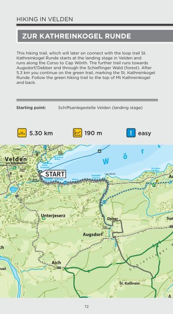
Grabner This hiking trail, which will later on connect with the loop trail St.<br />
Kathreinkogel Runde starts at the landing stage in Velden and<br />
runs along the Corso to Cap Wörth. The Kleiner further trail runs towards<br />
Augsdorf/Debber and through the Schieflinger<br />
See<br />
Wald (forest). After<br />
5.3 km you continue on the Landschaf green trail, tsschutzgebie<br />
t<br />
marking the St. Kathreinkogel<br />
Saisserach<br />
am See Landschaf Runde. tsschutzgebie<br />
and back.<br />
Follow the green hiking trail to the top of Mt Kathreinkogel<br />
Forstsee<br />
t<br />
er ger Str.<br />
. 2<br />
tz<br />
K ö s tenber g er<br />
Rotes Kreuz<br />
FF<br />
ungschanze<br />
83<br />
K<br />
Saissersee<br />
K<br />
St r.<br />
lös t en b e<br />
r a n z<br />
T<br />
e ufels<br />
g<br />
r g e r S t r.<br />
Kranzlhofen<br />
e n s t r a ß e<br />
r a ben<br />
am Wörthersee<br />
Sporthaus<br />
V i l l a c h e r S t<br />
r a ß e<br />
Kerschdorf<br />
Bahnhof<br />
Tennisplatz<br />
Strandbad<br />
Bulfon<br />
Strandclub<br />
K l a g e n f u r t e r S t<br />
Minigolfpl.<br />
Strandbad<br />
Wrann<br />
Schiffsstation<br />
Velden<br />
Strandbad Segel- u.<br />
Leopold Surfschule<br />
R ö m e r s c h l u c h t<br />
r a ß e<br />
Marina<br />
Schwarzendorf<br />
W i n<br />
R4<br />
k l<br />
Ebenfeld<br />
M etaubac h<br />
e r<br />
Bad<br />
Strandbad<br />
Augsdorf<br />
n f<br />
o r s t<br />
Cap Wörth<br />
Trabenig<br />
ÖBB-Südbahn<br />
Greilitz<br />
Forsthof<br />
Altes<br />
Forsthaus<br />
Starting point: Göriach Schiffsanlegestelle Velden (landing stage)<br />
Velden<br />
Kirche<br />
Friedhof<br />
Busbhf.<br />
Polizei<br />
HS<br />
a<br />
km<br />
5.30 km<br />
VS<br />
Schloss<br />
Kirche<br />
Beachvolleyball<br />
START<br />
Kirche<br />
a<br />
Unterwinklern<br />
83<br />
Hohes<br />
Kreuz<br />
VELDEN OST<br />
Schiffsstation<br />
Kraftwerk Forstsee<br />
S Ü D A U<br />
a190 measy<br />
W ö r<br />
Hadanig<br />
Josefikapelle<br />
T O<br />
Strandbad<br />
Schiefling<br />
B A H N<br />
Fitnesparcours<br />
Veranstaltungshalle<br />
Auen<br />
Te c helsberg<br />
am Wörthersee<br />
Strandbad<br />
Seerose<br />
Gemeindeamt<br />
900<br />
800<br />
700<br />
600<br />
Velden<br />
A2<br />
500<br />
t h e<br />
Kirche<br />
Pavor<br />
400<br />
0,0<br />
Saag<br />
Strandbad<br />
Tennisplatz<br />
St. Martin<br />
am Techelsberg<br />
Tibitsch<br />
Karawankenblick<br />
1<br />
Hasendorf<br />
Bad<br />
Schiffsstation<br />
Weißes Rössl<br />
Kapelle<br />
680<br />
PÖRTSCHACH<br />
WEST<br />
R4<br />
Bad<br />
r s e e<br />
Stb.<br />
Hst.<br />
Wallerwirt<br />
Töschling<br />
Hiking in Velden<br />
2 3 4 5<br />
Camping<br />
Weißes Rössl<br />
Trieblach<br />
Sekull<br />
A2<br />
Schloss Seefels<br />
Schiffsstation<br />
Dellach<br />
Dellach<br />
Golfplatz<br />
Dellach<br />
S Ü D A U T<br />
W i n d i s<br />
r g<br />
c h b e<br />
Windischberg<br />
O B<br />
-85,2 m<br />
A<br />
Gesundheitszentrum<br />
Mayr & More<br />
Mühlbach<br />
H N<br />
Hohe Gloriette<br />
Golfplatz<br />
Dellach<br />
Barfußweg<br />
Ruine<br />
Leonstein<br />
536<br />
83<br />
Kathreinkogel<br />
Runde<br />
Res.<br />
W e s t<br />
Hexenhaus<br />
Glorietteweg<br />
Wörthersee Südufer<br />
Rennweg<br />
M o o s b u r g e r<br />
b u<br />
Str<br />
.<br />
Kollerweg<br />
c h<br />
t<br />
R4<br />
Res.<br />
St r.<br />
Ka<br />
VS<br />
Kir<br />
Tennishal<br />
Koschat<br />
Denkmal<br />
Schiffsstatio<br />
Werze<br />
Pörtschach<br />
am Wörtherse<br />
Teixlkreuz<br />
Prom<br />
Beachvolleyba<br />
Bärenkreuz<br />
Waldarena<br />
Sportpl.<br />
t r a ß e<br />
lpritsch<br />
AU<br />
Duel<br />
Bäckerteich<br />
K e u<br />
R4A<br />
t<br />
s c h a<br />
S<br />
ü d u<br />
R o s e n t a l e r<br />
c h e r<br />
S t r a ß e<br />
f e r<br />
s t<br />
S t r a ß e<br />
e<br />
r a ß<br />
Unterjeserz<br />
Aich<br />
R4A<br />
S ü d<br />
Ex celsior<br />
u<br />
f<br />
e r s t<br />
str.<br />
r<br />
a<br />
ß<br />
e<br />
Augsdorf<br />
Freiw.<br />
Feuerwehr<br />
Deber<br />
Tratten<br />
R4A<br />
S c h i e f l i n g e r W<br />
a l d<br />
K eutschacher Str.<br />
Farrendor f er Straße<br />
Sportzentrum<br />
Schiefling<br />
Schule<br />
Gemeindeamt<br />
Start<br />
von:<br />
Farrendorf<br />
S u r i a<br />
Kirche<br />
Beachvolleyball<br />
K e u t s c h a c h e r<br />
S t r<br />
Schiefling<br />
am Wörthersee<br />
R a k o u z a b a c h<br />
.<br />
Techelweg<br />
Zauchen<br />
Kirche<br />
Tec he lbac h<br />
Oberalbersdorf<br />
Albersdorf<br />
Roda<br />
Höhe<br />
VELDEN<br />
R1<br />
St. Kathrein<br />
K u r a n<br />
Freiw.<br />
Feuerwehr<br />
H a f n e r s e e<br />
S<br />
R4AH<br />
Familycampin<br />
Hafnersee<br />
DRAU<br />
Latschach<br />
St. Stefan<br />
O<br />
a<br />
t u c h o w<br />
<strong>Kern</strong>a<br />
Kathreinkogel 772<br />
Stb. Römische<br />
St. Kathrein<br />
72 Ausgrabungen<br />
73<br />
Ramplercenter<br />
Kirche<br />
Kapelle<br />
P e n k e n<br />
Penkensiedlung<br />
Penkensee