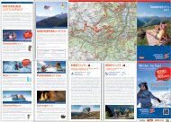
Sommerinfo 2012 Winter im Tuxertal - Hintertuxer Gletscher
Sommerinfo 2012 Winter im Tuxertal - Hintertuxer Gletscher
Sommerinfo 2012 Winter im Tuxertal - Hintertuxer Gletscher

Sie wollen auch ein ePaper? Erhöhen Sie die Reichweite Ihrer Titel.
YUMPU macht aus Druck-PDFs automatisch weboptimierte ePaper, die Google liebt.
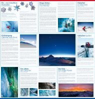
HINTERTUX GLACIER WORLD<br />
<strong>Hintertuxer</strong><br />
<strong>Gletscher</strong>welt<br />
Österreichs einziges Ganzjahresskigebiet bietet neben Skispaß an<br />
365 Tagen <strong>im</strong> Jahr, in den Sommermonaten ein 250 km langes Wanderwege-<br />
und Bikenetz sowie viele Highlights.<br />
Austria’s only year-round resort offers unparalleled ski fun 365 days<br />
of the year, 250 km of beautiful walking trails in the summer months<br />
as well as extensive mountain bike trails and many top highlights.<br />
Natur Eis Palast<br />
Spannagelhöhle<br />
SPANNAGEL CAVE<br />
Die zum Naturdenkmal erklärte Spannagelhöhle ist ein wahres Naturjuwel!<br />
Neben farbigem Marmor, Tropfsteinen, Kristallen und Erosionskolken<br />
besticht die Höhle durch ein einzigartiges Farbenspiel.<br />
The Spannagel Cave has been declared a site of outstanding<br />
natural beauty and is a true natural treasure!<br />
In addition to coloured marble, stalactites, crystals, fascinating<br />
pools and potholes, visitors are captivated by an<br />
extraordinary display of natural colours.<br />
<strong>Gletscher</strong>fl ohparks<br />
NATURE’S ICE PALACE<br />
Dieses einzigartige Naturjuwel am <strong>Hintertuxer</strong> <strong>Gletscher</strong> besticht mit<br />
natürlich entstandenen Eisformationen und glitzernden Eiskristallen.<br />
Meterlange Eiszapfen und beeindruckende Eiswände versetzen alle<br />
Besucher ins Staunen.<br />
This unique natural gem on the Hintertux Glacier fascinates<br />
with naturally occurring ice formations and sparkling<br />
ice crystals. Visitors of all ages are mesmerized by metre<br />
long icicles and <strong>im</strong>pressive walls of ice.<br />
GLACIER FLEA PARKS<br />
Gemeinsam mit <strong>Gletscher</strong>fl oh Luis wird rasant die Bobbahn runtergedüst,<br />
<strong>im</strong> Schneekarussell eine Runde gedreht oder die Spielburg<br />
erobert! Kleine <strong>Gletscher</strong>helden kommen in den Flohparks am <strong>Hintertuxer</strong><br />
<strong>Gletscher</strong> garantiert auf ihre Kosten!<br />
Together with „Luis“ the glacier fl ea, young mountain<br />
lovers can whizz downhill on the snow bob run, enjoy<br />
a few rounds on the snow carousel or cl<strong>im</strong>b the bouncy<br />
castle! Great fun is guaranteed to young glacier heroes at<br />
the Hintertux Glacier Flea Parks!<br />
BAD WEATHER<br />
ALTERNATIVES<br />
SCHLECHT-<br />
WETTERTIPP!<br />
MOUNTAINBIKE<br />
Mountainbike<br />
Die kristallklare Bergluft und die beeindruckende Naturkulisse lassen<br />
Radsportherzen höher schlagen. Die ersten Höhenmeter überwindet<br />
man bequem per Gondel. Der kostenlose Biketransport ermöglicht<br />
problemlose Einstiege für einmalige Bike-Erlebnisse.<br />
Crystal clear mountain air and stunning natural scenery provide the<br />
perfect setting for all mountain bike enthusiasts. The initial ascent is<br />
made easy by using the gondola. Free bike transport provides convenient<br />
access to exciting bike trails.<br />
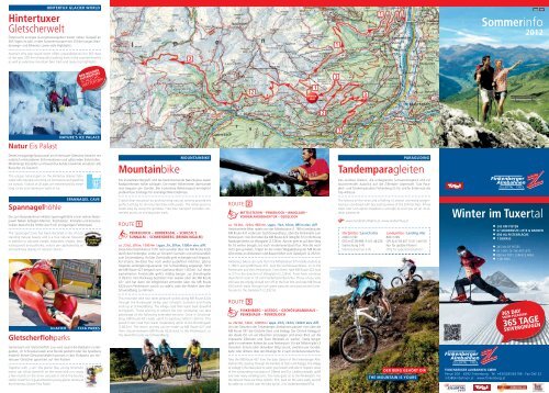
ROUTE 1<br />
PENKENJOCH – HORBERGTAL – SCHIESTL’S<br />
SUNNALM – SCHWENDBERG (BRINDLINGALM)<br />
ca. 2 Std., 20 km, 1500 Hm / appx. 2 h, 20 km, 1500 m elev. diff.<br />
Diese Mountainbiketour führt Genussradler über die MB Route 422b<br />
durch das Horbergtal, vorbei an Schiestl’s Sunnalm und schlussendlich<br />
zum Schwendberg. Auf der Dorfstraße geht es bergab nach Hippach.<br />
Für all jene, die diese Tour noch weiter ausdehnen möchten, gibt es<br />
folgende Verlängerungsvariante: Am Schwendberg angelangt, führt<br />
die MB Route 421 bergauf zum Gasthaus Mösl (1.500 m). Auf dieser<br />
asphaltierten Forststraße geht’s mäßig bergan zur Brindlingalm<br />
(1.823 m). Den Rückweg bestreitet man wieder über die MB Route<br />
421 und hat dann die Möglichkeit entweder über die MB Route<br />
422b zum Penkenjoch zurück zu radeln, oder die Abfahrt über den<br />
Schwendberg zu nehmen.<br />
This mountain bike tour takes pleasure cyclists along MB Route 422b<br />
through the Horbergtal Valley, past Schiestl’s Sunnalm and finally<br />
ends up at Schwendberg. The village road then leads back downhill<br />
to Hippach. Those wishing to extend the tour somewhat can take<br />
advantage of the following extended versions: Once in Schwendberg,<br />
MB Route 421 leads uphill to Gasthaus Mösl (1,500 m). This<br />
paved forest road then leads moderately uphill to the Brindlingalm<br />
(1,823 m). The return journey can be made via MB Route 421 and<br />
then choose between MB Route 422b back to the Penkenjoch, or<br />
the downhill route via Schwendberg.<br />
2<br />
© Zillertal Tourismus GmbH / Daniel Geiger<br />
ROUTE 2<br />
MITTELSTATION – PENKENJOCH – WANGLALM –<br />
VORDERLANERSBACH/TUX – GEISELJOCH<br />
PENKEN<br />
JOCH<br />
ca. 1¾ Std., 10 km, 985 Hm / appx. 1¾ h, 10 km, 985 m elev. diff.<br />
Ambitionierte Biker radeln von der Mittelstation (1.780 m) entlang der<br />
MB Route 437 vorbei am Gschösswandhaus, über die Penkenalm zum<br />
Penkenjoch. Von dort über die MB Route 422 (Weg Nr. 57) in Richtung<br />
Rastkogel direkt zur Wanglalm (2.128 m). Ab hier geht es auf dem Weg<br />
Nr. 55 weiter bergab, bis nach Vorderlanersbach/Tux. Alle die noch<br />
nicht genug haben, folgen an der ersten Weggabelung der MB Route<br />
424 vorbei an Almwiesen und Bauernhöfen zum Geiseljoch (2.292 m).<br />
Ambitious bikers can cycle from the Mittelstation (lift middle station) at<br />
1,780 m along MB Route 437, past the Gschösswandhaus, on to the<br />
Penkenalm and then Penkenjoch. From there, take MB Route 422 (trail<br />
nr. 57) in the direction of Wanglalm (2,128 m). From here, continue<br />
downhill on trail nr. 55 until Vorderlanersbach/Tux. Those of you who<br />
still have the energy should turn off at the fi rst fork and take MB Route<br />
424 which leads through lush green pastures and past ancient farmhouses<br />
to the Geiseljoch (2,292 m).<br />
ROUTE 3<br />
2<br />
FINKENBERG – ASTEGG – GSCHÖSSWANDHAUS –<br />
PENKENALM – PENKENJOCH<br />
ca. 2¾ Std., 14 km, 1200 Hm / appx. 2¾ h, 14 km, 1200 m elev. diff.<br />
Von der Talstation der Finkenberger Almbahnen passiert man über die<br />
MB Route 437 die Ortsteile Stein und Astegg. Der Ortsteil Astegg ist<br />
der ideale Ort um ein Päuschen einzulegen und einen Blick auf die<br />
<strong>im</strong>posante Zillertaler und Tuxer Bergwelt zu werfen. Stetig bergan<br />
geht’s in mehreren Kehren bis zum Penkenjoch. Für die Talfahrt gibt’s 3<br />
Varianten: Erstens über denselben Weg zurück, zweitens per Gondelbahn<br />
oder drittens über den Biketipp Nr. 2 nach Vorderlanersbach/Tux.<br />
Take the MB Route 437 from the base station of the Finkenberger Almbahnen<br />
lifts, passing through the hamlets of Stein und Astegg. The village<br />
of Astegg is the ideal place to catch your breath and take in majestic views<br />
of the surrounding mountains of Zillertal and Tux. Leading steadily uphill<br />
and over many winding turns, this route goes on to the Penkenjoch. For<br />
the descent there are three options: First, back on the same path, second<br />
by cable car or third, over the bike tip No. 2 to Vorderlanersbach/Tux.<br />
1<br />
2<br />
1<br />
3<br />
3<br />
3<br />
PARAGLIDING<br />
Tandemparagleiten<br />
Das lautlose Gleiten, die unbegrenzte Schwerelosigkeit und ein<br />
faszinierender Ausblick auf die Zillertaler Alpenwelt. Das Paragleit-<br />
und Tandemparadies Finkenberg ist für solche Erlebnisse die<br />
Top-Adresse.<br />
The silence of the skies and a feeling of almost unl<strong>im</strong>ited weightlessness<br />
combined with fascinating views of the Zillertal Alps. A few<br />
steps over lush alpine meadows is enough to start you on an incredible<br />
adventure.<br />
www.tandemfunfl ights.at, www.tandemfl ug.at<br />
1<br />
Startplätze / Launch sites<br />
2080 m NN<br />
GPS N 47.09.998 / E 011.48.226<br />
Startrichung S-W<br />
Starting direction S-W<br />
Landeplätze / Landing sites<br />
880 m NN<br />
GPS N 47.09.457 / E 011.49.516<br />
Nur für geübte Piloten!<br />
Only for experienced pilots!<br />
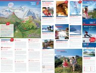
DER BERG GEHÖRT DIR<br />
THE MOUNTAIN IS YOURS<br />
© Zillertal Tourismus GmbH / Daniel Geiger<br />
<strong>Sommerinfo</strong><br />
<strong>2012</strong><br />
<strong>Winter</strong> <strong>im</strong> <strong>Tuxertal</strong><br />
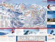
245 KM PISTEN<br />
67 MODERNSTE LIFTE & BAHNEN<br />
800 HA PISTENFLÄCHE<br />
1 SKIPASS<br />
245 KM OF PISTES<br />
67 STATE OF THE ART LIFTS<br />
800 HA PISTE SURFACE AREA<br />
1 SKI PASS<br />
365 DAY<br />
SNOW PLEASURE!<br />
365 TAGE<br />
SKIVERGNÜGEN<br />
FINKENBERGER ALMBAHNEN GMBH<br />
Persal 200 · 6292 Finkenberg · Tel. +43/5285/62196 · Fax DW 23<br />
info@almbahnen.at · www.finkenberg.at
1 Penkenjoch<br />
PENKENJOCH – MITTELSTATION<br />
ca. 1 Stunde / appx. 1 h<br />
Vom Penkenjoch (2.095 m) aus erkundet man den Erlebnisberg Penken<br />
anhand des Weges Nr. 22a. Vorbei an prachtvoll blühenden Bergwiesen<br />
entlang des Weges Nr. 22 erreicht man nach knapp einer Stunde die<br />
Mittelstation. Von wo aus man mit der Gondel ins Tal fährt oder über<br />
die Walkingtour bzw. den Moorlehrpfad absteigt.<br />
Mount Penken can be explored along trail nr. 22a, starting from the<br />
Penkenjoch (2,095 m). The route leads via trail nr. 22 through fl owering<br />
meadows and on to the Mittelstation in around 1 hour. Alternative<br />
options for the descent can also be found in route Walkingtour<br />
or Moorlehrpfad.<br />
PENKENJOCH – RASTKOGEL<br />
ca. 7 Stunden / appx. 7 h<br />
Mit den Finkenberger Almbahnen gondelt man bequem zum Penkenjoch<br />
(2.095 m). Von hier aus geht‘s über den Weg Nr. 57 vorbei an der<br />
Wanglalm zum Wanglspitz (2.420 m). Ab der Bergstation der Sesselbahn<br />
Horbergjoch begeht man den markierten Steig Nr. 51 bis zum<br />
höchsten Gipfel der Tuxer Voralpen dem Rastkogel (2.762 m), von dort<br />
eröffnet sich ein grandioser Dreitälerblick übers Inn-, Tuxer- und Zillertal.<br />
Der Abstieg erfolgt entweder über denselben Weg zurück zur<br />
Bergstation oder über den Westgrat auf dem markierten Abstieg<br />
Nr. 318 zur Geiselalm und von dort über die Geiselhöfe nach Vorderlanersbach/Tux.<br />
A convenient and comfortable ascent to the Penkenjoch (2,095 m) is<br />
provided by the Finkenberger Almbahnen lifts. From there, trail nr. 57<br />
leads past the Wanglalm and on to the Wanglspitz Peak (2.420 m).<br />
From the top station of the Horbergjoch chair lifts, trail nr. 51 leads to<br />
the highest peak in the foothills of the Tux Alps, the Rastkogel<br />
(2.762 m), from where magnifi cent views open up across three valleys;<br />
Inn, Tux and Zillertal. The descent can be made either via the same<br />
route back to the top station of the lifts, or via the west ridge along<br />
marked trail Nr. 318 to the Geiselalm and then the Geiselhöfe to Vorderlanersbach/Tux.<br />
ENERGIE TANKEN AM SPEICHERTEICH<br />
RECHARGE YOUR BATTERIES<br />
2<br />
1<br />
INSIDER TIP!<br />
RUNDWANDERWEG ZUM SPEICHERTEICH<br />
ca. ¼ Stunden / appx. ¼ h<br />
GEHEIMTIPP!<br />
Diese idyllische Rundwanderung um den Speicherteich am Penkenjoch,<br />
auf 2.095 m, ist bestens geeignet für kleine Wanderfans und<br />
ebenfalls mit dem Kinderwagen hervorragend zu meistern. Zahlreiche<br />
Bänke rund um den See laden zum Verweilen und Träumen ein.<br />
This idyllic round walk at the Penkenjoch Reservoir at 2,095 m is particularly<br />
suitable for young walkers and can be easily negotiated using a<br />
pram. Plenty of welcoming benches dotted around the lake invite you<br />
to linger and relax.<br />
2 Mittelstation<br />
WALKINGTOUR<br />
ca. 2 Stunden / appx. 2 h<br />
Diese ausgedehnte Walkingtour beginnt an der Mittelstation (1.780 m).<br />
Man folgt dem Naudisweg, welcher zwischen dem Moorlehrpfad<br />
und dem Weg Nr. 28 liegt. Auf dem Weg Nr. 28 gelangt man zur<br />
Bushaltestelle Persal. All jene, die die Walkingtour noch etwas ausdehnen<br />
möchten, folgen dem Naudisweg bis zum Ortsteil Stein, von<br />
dort führt der Weg Nr. 25 hinab ins Dorf.<br />
This extensive walking tour begins at the Mittelstation (lift middle station)<br />
at 1,780 m. Follow the Naudisweg trail, which lies between the<br />
Moor Nature Trail and trail nr. 28. Trail nr. 28 will lead you to the bus<br />
stop at Persal. Those of you who would like to extend this walking tour<br />
should follow the Naudisweg trail until the little village of Stein, from<br />
where trail nr. 25 leads back down into the village.<br />
MOORLEHRPFAD<br />
ca. 2½ Stunden / appx. 2½ h<br />
NATURAL TIP!<br />
NATURTIPP!<br />
Von der Mittelstation auf 1.780 m erreicht man direkt den Moorlehrpfad<br />
(Weg Nr. 22b). Entlang von Sumpfböden und saftigen Almwiesen<br />
folgt man an der Weggabelung entweder dem Weg Nr. 57 talwärts<br />
und danach dem Weg Nr. 55 bis nach Vorderlanersbach/Tux oder<br />
wählt den kurzen Aufstieg über den Weg Nr. 57 zum Penkenjoch.<br />
Den Abstieg vom Penkenjoch bewältigen Wanderer zu Fuß (siehe<br />
Penkenjoch – Rastkogel) oder fahren mit der Panoramagondel ins Tal.<br />
Ab Vorderlanersbach/Tux geht’s bequem per Linienbus Nr. 4104 zurück<br />
zur Talstation in Finkenberg.<br />
The Moor Nature Trail can be accessed directly from the Mittelstation<br />
(middle lift station) at 1.780 m (trail nr. 22b). Walking along the edge<br />
of swamps and lush alpine meadows, following trail nr. 57 down<br />
towards the valley and then trail nr. 55 until Vorderlanersbach/Tux, or<br />
go for the short ascent to the Penkenjoch via trail nr. 57. Ambitious<br />
hikers will be able to walk down from the Penkenjoch (see Penkenjoch<br />
– Rastkogel). Those who prefer a faster descent can catch the lift<br />
down. The 4104 bus service provides transport back from Vorderlanersbach/Tux<br />
to the base station of the lifts in Finkenberg.<br />
ATEMBERAUBENDE AUSBLICKE<br />
BREATHTAKING VIEWS<br />
WHEN THE MOUNTAIN CALLS<br />
Wenn der Berg ruft!<br />
Das charmante Wandergebiet Finkenberg/Penken ist wahrlich ein<br />
Kleinod für Aktiv- und Berggenießer. Erholungssuchende und Naturliebhaber<br />
fi nden inmitten der atemberaubenden Landschaft des Hochgebirgspark<br />
Zillertaler Alpen jede Menge Möglichkeiten die Seele<br />
baumeln zu lassen und Kraft zu tanken. Doch auch das sensationelle<br />
Sportangebot lockt zahlreiche Wanderer, Biker und Paragleiter.<br />
This charming hiking region around Finkenberg/Mount Penken is a<br />
great destination for active holiday and mountain enthusiasts Holidaymakers<br />
and nature lovers will be able to indulge in the essential<br />
pleasures of rest, relaxation and revitalisation in the midst of the stunning<br />
landscapes of the Zillertal Alps Nature Park. Sensational sporting<br />
opportunities also attract many hikers, bikers and paragliders.<br />
PUR UND ECHT – DAS NIEDERMOOR<br />
PUR AND GENUINE – THE FENLANDS<br />
Niedermoor<br />
LOWLAND MOORS<br />
Niedermoore entstehen bevorzugt in kühlen und feuchten Gebieten<br />
in denen mehr Niederschlag fällt als verdunstet. Der hohe Wassergehalt<br />
und die besonderen Nährstoffverhältnisse der Moore bieten<br />
Lebensräume für seltene Tier- und Pflanzenarten. Durch den konstanten<br />
Sauerstoffmangel der Moore erfolgt ein unvollständiger<br />
Abbau der pfl anzlichen Reste, die sich als Torf ablagern. An der Zusammensetzung<br />
von Torfen lassen sich frühere Vegetations- und<br />
Kl<strong>im</strong>averhältnisse ablesen und dienen daher als wichtige Archive<br />
der Natur- und Kulturgeschichte.<br />
Lowland moors tend to develop in cool and humid areas where<br />
more rain falls than evaporates. The resultant high water content<br />
and distinctive nutrient content of the moors offer a very special<br />
habitat for rare an<strong>im</strong>als and plants. Constant lack of oxygen means<br />
that plant residues are unable to completely decompose, resulting<br />
in peat deposits. Analysis of the peat composition has enabled us to<br />
understand earlier vegetation and cl<strong>im</strong>ate conditions and is therefore<br />
an <strong>im</strong>portant archive of natural and cultural history.<br />
Tarife Bergbahn<br />
WANDERER ERWACHSENE KINDER<br />
HIKERS ADULT CHILDREN<br />
Bergfahrt Mittelstation (1780 m)<br />
Acent Middle station<br />
Berg- und Talfahrt Mittelstation<br />
Ascent and decent Middle station<br />
Bergfahrt Penkenjoch (2095 m)<br />
Acent Penkenjoch<br />
Berg- und Talfahrt Penkenjoch<br />
Ascent and decent Penkenjoch<br />
Volle Bergfahrt & halbe Talfahrt<br />
Full ascent with parcial decent<br />
PRICES<br />
SOMMER BETRIEBSZEITEN 2. - 3.06.12, 7.6. - 14.10.12<br />
08.45 - 17.00 Uhr; Letzte Talfahrt Penkenjoch 16.30 Uhr / Letzte<br />
Talfahrt Mittelstation 16.45 Uhr<br />
OPERATING TIMES 2. - 3.06.12, 7.6. - 14.10.12<br />
08.45 am - 05.00 pm; last decent Penkenjoch 04.30 pm / last<br />
decent Middle station 04.45 pm<br />
8,50 7,40* 5,30 5,00*<br />
11,00 9,60* 7,30 6,60*<br />
11,00 9,60* 7,30 6,60*<br />
16,00 14,20* 9,80 8,90*<br />
14,50 13,00* 9,30 8,40*<br />
* Preise mit Tux-Finkenberg Ticket<br />
Kinder frei: nach dem 01.01.2003 geboren in Begleitung der Eltern. Jahrgänge 1997 bis<br />
2002 erhalten Kindertarif. Ausweispfl icht!<br />
* Prices with Tux-Finkenberg ticket<br />
Children born after 01.01.2003 free of charge, when accompanied by adult. Children<br />
born 1997 – 2002 pay children’s rate. ID necessary!<br />
MOUNTAINBIKER ERWACHSENE KINDER<br />
MOUNTAINBIKER ADULT CHILDREN<br />
5-Bergfahrten-Ticket / Ascent 49,90 25,00<br />
Action-Day-Ticket 24,00 12,00<br />
Das 5-Bergfahrten-Ticket berechtigt zur Nutzung von 5 Bergfahrten ab Verkaufsdatum<br />
bis 14.10.<strong>2012</strong>. Die Tage müssen nicht zusammenhängend konsumiert werden.<br />
Action-Day-Ticket: Tageskarte mit unbegrenzten Berg- und Talfahrten.<br />
The 5-Mountain-Ascent-Ticket entitles the user to 5 mountain ascents from the date of<br />
purchase until 14.10.<strong>2012</strong>. It is not necessary to use the individual days consecutively.<br />
Action-Day-Ticket: Day ticket with unl<strong>im</strong>ited mountain ascents and descents.<br />
PARAGLEITER<br />
PARAGLIDERS<br />
Bergfahrt Penkenjoch / Ascent Penkenjoch 14,00<br />
1 Tageskarte / Day Ticket 24,50<br />
20 Punktekarte / Points Ticket 104,00<br />
30 Punktekarte / Points Ticket 145,00<br />
40 Punktekarte / Points Ticket 188,00<br />
50 Punktekarte / Points Ticket 220,00<br />
Saisonkarte / Season Ticket 161,00<br />
Im Preis inbegriffen ist der von uns zur Verfügung gestellte Landeplatz neben der Stütze 2<br />
der 4er-Kabinenbahn, welcher markiert ist. Die Liftgesellschaft übern<strong>im</strong>mt keinerlei Haftung<br />
für Landungen außerhalb der Markierung. Es muss mit Schadenersatzforderungen<br />
der Grundeigentümer gerechnet werden.<br />
We have provided a marked landing strip situated next to the second support mast of the four<br />
seater cabin lift, which is included in the price. The lift company accepts no liability for landings<br />
outside of the marked area. The landlords reserve the right to cla<strong>im</strong> for compensation.<br />
ZILLERTAL ACTIVCARD ERWACHSENE KINDER<br />
ZILLERTAL ACTIVCARD ADULT CHILDREN<br />
6 Tage / Days 53,50 26,80<br />
9 Tage / Days 73,50 36,80<br />
12 Tage / Days 92,50 46,30<br />
Kinder ab Jahrgang 2006 und jünger werden kostenlos befördert, Jahrgänge 1997 – 2005<br />
bezahlen den Kindertarif. Familienkarte: Be<strong>im</strong> Kauf von 2 Erwachsenenkarten (Eltern) fahren<br />
deren Kinder sogar bis Jahrgang 1997 gegen Ausweisvorlage gratis! Nähere Informationen<br />
in der Broschüre Zillertal Activcard <strong>2012</strong>.<br />
Children born in 2006 and later travel free; Children born in 1997-2005 pay childrate; Family ticket:<br />
When purchasing 2 adult tickets (parents), their children born in 1997 or later travel free upon<br />
presentation of identifi cation. For further information please take a Zillertal Activcard Folder <strong>2012</strong>.<br />
Bergsteig für Geübte<br />
Trail for experienced<br />
Mittelschwere Bergtour<br />
Moderate hike<br />
Leichter Wanderweg<br />
Easy hike<br />
Trail für Geübte<br />
Trail for experienced<br />
Leichte Tour<br />
Easy tour<br />
Hinweis<br />
Advice<br />
Preise für Mehrtageskarten auf Anfrage! Alle Preise verstehen sich in Euro inkl. sämtlicher<br />
Abgaben und Steuern. Druck- und Satzfehler vorbehalten. Prices for multiple day passes<br />
on request! All prices in EURO including all taxes. Errors and misprints excepted.