Raben Steinfeld und die Eiszeit: Landschaftsentwicklung und ...
Raben Steinfeld und die Eiszeit: Landschaftsentwicklung und ...
Raben Steinfeld und die Eiszeit: Landschaftsentwicklung und ...

Sie wollen auch ein ePaper? Erhöhen Sie die Reichweite Ihrer Titel.
YUMPU macht aus Druck-PDFs automatisch weboptimierte ePaper, die Google liebt.
gen zum Thema <strong>Eiszeit</strong> <strong>und</strong> Geschiebe – der Findlingsgarten<br />
<strong>und</strong> das Geologische Museum – sind Anziehungspunkte für<br />
geologisch Interessierte <strong>und</strong> ein weiteres naturk<strong>und</strong>liches<br />
Bildungsangebot für Schulklassen im Großraum Schwerin.<br />
Summary<br />
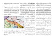
The Pleistocene glacial landscape in the southeast of Schwerin<br />
was primarily formed by the ice advance of the Frankfurt<br />
stage, and secondarily overprinted by the ice advances of<br />
the Pomeranian stage during the Weichselian glacial period.<br />
Main morphological units are the Frankfurt terminal<br />
moraine between Crivitz and Schwerin as well as the large<br />
Sülstorf sander and the minor <strong>Raben</strong> <strong>Steinfeld</strong> sander. The<br />
Schwerin lake was formed first as subglacial channel during<br />
the Brandenburg/Frankfurt ice advance. Melt water <strong>und</strong>er<br />
hydrostatic pressure eroded older deposits, and sander sediments<br />
were laid down in the glacial foreland. Later, a melt<br />
water channel developed during the Pomeranian main ice<br />
advance. The melt water, which flew from the recent northern<br />
end of the lake southwards, led to a break through in<br />
the Frankfurt terminal moraine and sander formation near<br />
Mueß that resulted in the creation of the Stör valley. Slightly<br />
earlier, melt water of the Pomeranian maximal ice advance<br />
had already led to an about 3 km wide break through<br />
in the Frankfurt terminal moraine between <strong>Raben</strong> <strong>Steinfeld</strong><br />
and Crivitz further to the East. There, the Pomeranian sander<br />
was deposited at a level situated 20 m deeper than the<br />
Frankfurt sander. These melt water deposits graduated into<br />
valley sands in the Lewitz low land area.<br />
The village <strong>Raben</strong> <strong>Steinfeld</strong>, named after the occurrence of<br />
large erratic boulders southeast of the Schwerin lake, host in<br />
its borders a distinct Quaternary unit. Framed by lakes and<br />
younger deposits, a full geological/morphological set of the<br />
glacial series of the Frankfurt stage as a part of Weichselian<br />
glacial period is exposed. Special geosites refer to the development<br />
of the landscape during the Pleistocene. Two regional<br />
exhibitions about the ice age and erratic boulders – the<br />
Findlingsgarten (erratic boulder exhibition) and the Geological<br />
Museum – are attractions for people who are interested<br />
in geology. They also can be used by schools as opportunities<br />
for children to get in touch with Earth’s history in the<br />
broader area of Schwerin.<br />
Dank<br />
Der <strong>Raben</strong> <strong>Steinfeld</strong>er Findlingsgarten konnte nur mit Unterstützung<br />
zahlreicher Personen <strong>und</strong> Firmen errichtet werden.<br />
Stellvertretend soll hier besonders der Gemeinde <strong>Raben</strong><br />
<strong>Steinfeld</strong> für <strong>die</strong> großzügige finanzielle Unterstützung bei der<br />
Gestaltung des Findlingsgartens <strong>und</strong> seines Umfeldes sowie<br />
seiner laufenden Pflege gedankt werden. Für <strong>die</strong> fachlichen<br />
Hinweise bei der Geschiebebestimmung geht besonderer<br />
Dank an <strong>die</strong> Herren Prof. Dr. Roland Vinx (Hamburg), Matthias<br />
Bräunlich (Hamburg) <strong>und</strong> Johannes Kalbe (Rostock).<br />
Literatur<br />
hans-<strong>die</strong>ter krienke & karsten oBst<br />
andersson, u. B., sJöströM, h., högdahl k. & o. ekl<strong>und</strong><br />
(2004): The Transscandinavian Igneous Belt, evolutionary<br />
models. – In: högdahl, k., andersson, u. B. & o. ekl<strong>und</strong><br />
[eds]: The Transscandinavian Igneous Belt (TIB) in Sweden:<br />
a review of its character and evolution. – Geological<br />
Survey of Finland, Special Paper 37, S. 104 – 112, Espoo<br />
Benthien, B. (1956/57): Bemerkungen zur geomorphologischen<br />
Karte der Lewitz <strong>und</strong> zur Entwicklungsgeschichte<br />
<strong>die</strong>ser südwestmecklenburgischen Niederung. – Wiss.<br />
Zeitschr. Univ. Greifswald, Math.-Nat. Reihe VI, S.<br />
341 – 361, Greifswald<br />
Bogdanova, s. v., Bingen, B., gorBatschev, r., kheraskova,<br />
t. n., kozlov, v. i., puchkov, v. n. & y. a. volozh,<br />
(2008): The East European Craton (Baltica) before and<br />
during the assembly of Rodinia. – Precambrian Research<br />
160, 1/2, S. 23 – 45, Amsterdam<br />
BreMer, f. (2000): Geologische Karte von Mecklenburg-<br />
Vorpommern 1 : 500 000, Oberfläche. – Landesamt für<br />
Umwelt, Naturschutz <strong>und</strong> Geologie Mecklenburg-Vorpommern,<br />
Güstrow<br />
Brückner, W. (1960): Geologische Karte 1 : 25 000, Blatt<br />
2335 Langen Brütz für <strong>die</strong> Karte der an der Oberfläche<br />
anstehenden Bildungen 1 :100 000, Ebl. 35 Schwerin. –<br />
VEB GFE Nord, Schwerin (un veröff.)<br />
geinitz, e. (1886): Die mecklenburgischen Höhenrücken<br />
(Geschiebestreifen) <strong>und</strong> ihre Beziehungen zur <strong>Eiszeit</strong>. –<br />
Forschungen zur deutschen Landes- <strong>und</strong> Volksk<strong>und</strong>e 1, 5,<br />
S. 215 – 310, Stuttgart<br />
geinitz, E. (1922): Geologie Mecklenburgs. I. Teil: Diluvium<br />
<strong>und</strong> Alluvium. – 200 S., Rostock (C. Hinstorff)<br />
heck, H.-L. (1960): Brandenburger Phase oder Frühwürm<br />
bei Schwerin? – Geologie 9, S. 482 – 91, Berlin<br />
heck, H.-L. (1961): Glaziale <strong>und</strong> glaziäre Zyklen. Ein Prinzip<br />
des Quartärs, erläutert am Raum Mecklenburg. – Geologie<br />
10, 4/5, S. 378 – 395, Berlin<br />
kanter, l. (2000): Das Tollensebecken – ein ehemaliges<br />
Tunneltal. – Neubrandenburger Geol. Beitr. 1, S. 11 – 23,<br />
Neubrandenburg<br />
krienke, h.-d. & d. nagel (2002): Geologische Karte von<br />
Mecklenburg-Vorpommern 1 : 200 000 Karte der quartären<br />
Bildungen – Oberfläche bis fünf Meter Tiefe (ÜKQ 200) Blatt<br />
21/22 Boizenburg/Schwerin. – Landesamt für Umwelt, Naturschutz<br />
<strong>und</strong> Geologie Mecklenburg-Vorpommern, Güstrow<br />
krienke, h.-d. & k. oBst (2009): Findlingsgarten <strong>Raben</strong><br />
<strong>Steinfeld</strong>. Außenstandort der BUGA 2009. – Faltblatt<br />
122 Brandenburgische Geowissenschaftliche Beiträge 1/2-2011