


Create successful ePaper yourself
Turn your PDF publications into a flip-book with our unique Google optimized e-Paper software.
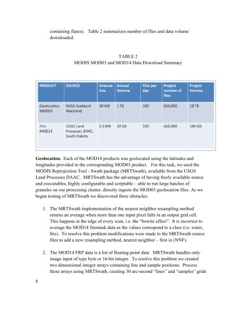
containing flares). Table 2 summarizes number of files and data volume<br />
downloaded.<br />
TABLE 2<br />
MODIS MOD03 and MOD14 Data Download Summary<br />
Geolocation. Each of the MOD14 products was geolocated using the latitudes and<br />
longitudes provided in the corresponding MOD03 product. For this task, we used the<br />
MODIS Reprojection Tool - Swath package (MRTSwath), available from the USGS<br />
Land Processes DAAC. MRTSwath has the advantage of having freely available source<br />
and executables, highly configurable and scriptable – able to run large batches of<br />
granules on our processing cluster, directly ingests the MOD03 geolocation files. As we<br />
began testing of MRTSwath we discovered three obstacles:<br />
8<br />
1. The MRTSwath implementation of the nearest neighbor resampling method<br />
returns an average when more than one input pixel falls in an output grid cell.<br />
This happens at the edge of every scan, i.e. the “bowtie effect”. It is incorrect to<br />
average the MOD14 firemask data as the values correspond to a class (i.e. water,<br />
fire). To resolve this problem modifications were made to the MRTSwath source<br />
files to add a new resampling method, nearest neighbor – first in (NNF).<br />
2. The MOD14 FRP data is a list of floating-point data. MRTSwath handles only<br />
image input of type byte or 16-bit integer. To resolve this problem we created<br />
two dimensional integer arrays containing line and sample positions. Process<br />
these arrays using MRTSwath, creating 30 arc-second “lines” and “samples” grids