Sanitary Servicing Overview - City of Kitchener
Sanitary Servicing Overview - City of Kitchener
Sanitary Servicing Overview - City of Kitchener

You also want an ePaper? Increase the reach of your titles
YUMPU automatically turns print PDFs into web optimized ePapers that Google loves.
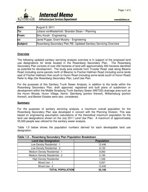
Date: August 9, 2011<br />
To: Juliane vonWesterholt / Brandon Sloan – Planning<br />
From: Binu Korah - Engineering<br />
cc Jared Puppe, Grant Murphy - Engineering<br />
Subject: Rosenberg Secondary Plan RE: Updated <strong>Sanitary</strong> <strong>Servicing</strong> <strong>Overview</strong><br />
<strong>Overview</strong><br />
Page 1 <strong>of</strong> 3<br />
The following updated sanitary servicing analysis overview is in support <strong>of</strong> the proposed land<br />
use designations for lands located in the Rosenberg Secondary Plan. The Rosenberg<br />
Secondary Plan consists <strong>of</strong> over 430 hectares <strong>of</strong> land with approximately 300 hectares identified<br />
as potential for development. The study area extends from Trussler Road, east along Bleams<br />
Road (including some parcels north <strong>of</strong> Bleams) to Fischer-Hallman Road (including some lands<br />
east <strong>of</strong> Fischer-Hallman) then south to Huron Road (including some lands south <strong>of</strong> Huron Road)<br />
Refer to Map 22e Rosenberg Secondary Plan, Land Use Plan.<br />
For the purposes <strong>of</strong> this <strong>Sanitary</strong> Trunk Sewer Analysis, in addition to the lands within the<br />
Rosenberg Secondary Plan, draft approved, registered and built plans <strong>of</strong> subdivision or<br />
development within the Middle Strasburg Trunk <strong>Sanitary</strong> Sewer (MSTSS) drainage area such as<br />
the Huron Woods, Huron Village, Norris- Sternberg (portion there<strong>of</strong>), Williamsburg (portion<br />
there<strong>of</strong>), and Becker Estates were also considered.<br />
Summary<br />
For the purposes <strong>of</strong> sanitary servicing analysis, a maximum overall population for the<br />
Rosenberg Secondary Plan was developed in concert with the Planning Division. This was<br />
based on engineering assumption calculations <strong>of</strong> the theoretical maximum population for the<br />
land use designations shown on the July 2011 Land Use Plan. A maximum <strong>of</strong> approximately<br />
55,000 people was utilized for the sanitary sewer analysis.<br />
Table 1.0 below shows the population numbers derived for each developable land use<br />
designation.<br />
Table 1.0 – Rosenberg Secondary Plan Population Breakdown<br />
Land Use Designation Population<br />
Low Density Residential - 1 12,446<br />
Low Density Residential - 2 8,132<br />
Medium Density Residential - 1 9,292<br />
Medium Density Residential - 2 5,195<br />
High Density Residential 1,346<br />
Mixed Use - 1 5,257<br />
Mixed Use - 2 13,440<br />
TOTAL POPULATION 55,108
Page 2 <strong>of</strong> 3<br />
The Engineering Division assessed the current service area for the MSTSS and the South<br />
Strasburg Trunk <strong>Sanitary</strong> Sewer (SSTSS) including an investigation <strong>of</strong> our sanitary capacity<br />
model. A total population assigned to the overall study area is approximately 71,000 people<br />
which include the lands within the Rosenberg Secondary Plan and all other urban lands within<br />
the respective drainage areas.<br />
Lands within the study area located to the northeast <strong>of</strong> Huron and Fischer Hallman Road and<br />
north <strong>of</strong> Williamsburg Cemetery are assigned to the MSTSS. All future developments located<br />
south <strong>of</strong> Huron Road, such as the Becker Estates Subdivision and a portion <strong>of</strong> the DPA Huron<br />
Woods Subdivision has been assigned to the SSTSS. Lands located west <strong>of</strong> Fischer Hallman<br />
Road between Huron Road and the Williamsburg Cemetery is assigned to the MSTSS or<br />
combination <strong>of</strong> the MSTSS and the SSTSS.<br />
This approach maximizes the MSTSS while accounting for the decommissioning <strong>of</strong> the existing<br />
Temporary Pumping Station (TPS) located on Bleams Road. This TPS currently provides<br />
service for the Norris-Sternberg and Williamsburg Subdivisions via the Borden Trunk Sewer.<br />
Upon extension <strong>of</strong> the MSTSS peak sanitary flows from the Norris-Sternberg and Williamsburg<br />
Subdivisions will be diverted from Borden Trunk Sewer to the MSTSS thereby eliminating the<br />
TPS on Bleams Road.<br />
Due to the high level assessment <strong>of</strong> this sanitary servicing analysis, some details are required to<br />
be addressed in order to best plan for, and utilize, future and existing municipal infrastructure.<br />
Areas that require further assessment include any future connection points to the MSTSS, as<br />
well as any areas which may necessitate the extension <strong>of</strong> the existing local municipal system. In<br />
recognition <strong>of</strong> the fact that some lands within the study area have options with respect to<br />
sanitary servicing and that other lands do not, the <strong>City</strong> will identify whether further studies and/or<br />
Class Environmental Assessments are warranted. The Landowner will be required to do further<br />
studies and/or Environmental Assessments at the Draft Plan <strong>of</strong> Subdivision stage. These<br />
conditions will apply to lands located south <strong>of</strong> the cemetery and north <strong>of</strong> Huron Road. Although<br />
these lands have been assigned to the MSTSS, the exact connection location and any<br />
extension <strong>of</strong> or upgrade to existing infrastructure has yet to be determined.<br />
Conclusions and Recommendations<br />
Based on the assessment completed to date the following conclusions and recommendations<br />
are provided:<br />
- All development land parcels north <strong>of</strong> Huron Road as designated on the Rosenberg Secondary<br />
Plan have been assigned to the Middle Strasburg Trunk <strong>Sanitary</strong> Sewer;<br />
- The capacity <strong>of</strong> the Middle Strasburg Trunk <strong>Sanitary</strong> Sewer has been maximized to<br />
accommodate the lands within Rosenberg Community Secondary Plan, and the existing and<br />
Draft Plan Approved subdivisions developments;<br />
- The Temporary Pumping Station located on Bleams Road is to be decommissioned at such<br />
time that the Middle Strasburg Trunk <strong>Sanitary</strong> Sewer becomes available to service the Norris-<br />
Sternberg and Williamsburg Subdivisions;
Page 3 <strong>of</strong> 3<br />
- Additional studies and/or Environmental Assessments in order to determine suitable<br />
connection location(s) to the Middle Strasburg Trunk <strong>Sanitary</strong> Sewer as well as any extension<br />
and/or upgrade to existing infrastructure will be required for those lands located north <strong>of</strong> Huron<br />
Road and south <strong>of</strong> the Cemetery and west <strong>of</strong> Fischer Hallman Road. Additional study<br />
requirements will be identified at the Draft Plan <strong>of</strong> Subdivision stage;<br />
- Based on the modeling work done and review <strong>of</strong> the land use plan, we conclude that the<br />
Middle Strasburg Trunk <strong>Sanitary</strong> Sewer and the South Strasburg Trunk <strong>Sanitary</strong> Sewer has<br />
sufficient capacity to provide sanitary servicing for all the land uses identified in the Rosenberg<br />
Secondary Plan, as well as the existing and Draft Plan Approved subdivisions identified in this<br />
report.