TOR VERGATA UNIVERSITY UNSUPERVISED CLASSIFICATION ...
TOR VERGATA UNIVERSITY UNSUPERVISED CLASSIFICATION ...
TOR VERGATA UNIVERSITY UNSUPERVISED CLASSIFICATION ...

Create successful ePaper yourself
Turn your PDF publications into a flip-book with our unique Google optimized e-Paper software.
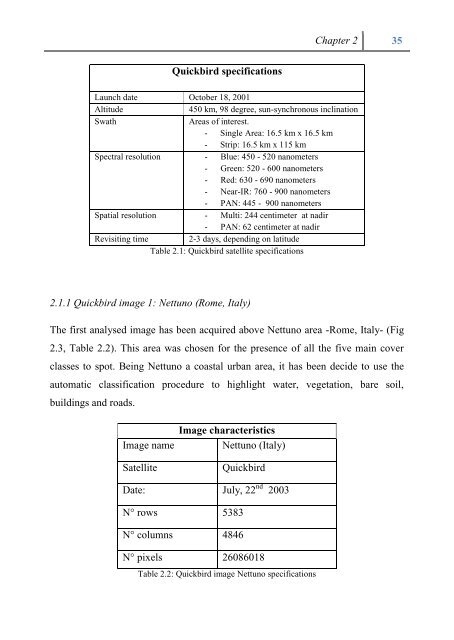
Quickbird specifications<br />
Chapter 2 35<br />
Launch date October 18, 2001<br />
Altitude 450 km, 98 degree, sun-synchronous inclination<br />
Swath Areas of interest.<br />
- Single Area: 16.5 km x 16.5 km<br />
- Strip: 16.5 km x 115 km<br />
Spectral resolution - Blue: 450 - 520 nanometers<br />
- Green: 520 - 600 nanometers<br />
- Red: 630 - 690 nanometers<br />
- Near-IR: 760 - 900 nanometers<br />
- PAN: 445 - 900 nanometers<br />
Spatial resolution - Multi: 244 centimeter at nadir<br />
- PAN: 62 centimeter at nadir<br />
Revisiting time 2-3 days, depending on latitude<br />
Table 2.1: Quickbird satellite specifications<br />
2.1.1 Quickbird image 1: Nettuno (Rome, Italy)<br />
The first analysed image has been acquired above Nettuno area -Rome, Italy- (Fig<br />
2.3, Table 2.2). This area was chosen for the presence of all the five main cover<br />
classes to spot. Being Nettuno a coastal urban area, it has been decide to use the<br />
automatic classification procedure to highlight water, vegetation, bare soil,<br />
buildings and roads.<br />
Image characteristics<br />
Image name Nettuno (Italy)<br />
Satellite Quickbird<br />
Date: July, 22 nd 2003<br />
N° rows 5383<br />
N° columns 4846<br />
N° pixels 26086018<br />
Table 2.2: Quickbird image Nettuno specifications