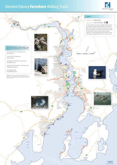
Derwent Estuary Foreshore Walking Tracks - Discover Tasmania
Derwent Estuary Foreshore Walking Tracks - Discover Tasmania
Derwent Estuary Foreshore Walking Tracks - Discover Tasmania

You also want an ePaper? Increase the reach of your titles
YUMPU automatically turns print PDFs into web optimized ePapers that Google loves.
<strong>Derwent</strong> <strong>Estuary</strong> <strong>Foreshore</strong> <strong>Walking</strong> <strong>Tracks</strong><br />
NEW<br />
NORFOLK<br />
<strong>Derwent</strong> Cliffs<br />
State Reserve<br />
For further information including individual maps,<br />
please refer to the following council publications:<br />
Popular Walks in Clarence and The Tangara Trail.<br />
www.ccc.tas.gov.au<br />
Glenorchy City Council Natural Areas.<br />
www.gcc.tas.gov.au<br />
1<br />
Tynwald<br />
Park<br />
Hobart Walks. A Guide to Hobart’s <strong>Tracks</strong> and Trails.<br />
www.hobartcity.com.au<br />
Kingborough’s <strong>Tracks</strong>. For walkers, horse riders and cyclists.<br />
www.kingborough.tas.gov.au<br />
Mount Wellington Walks.<br />
www.wellingtonpark.org.au<br />
2<br />
Disclaimer: Please note that track conditions may change. When walking in the natural<br />
environment you may encounter natural hazards. Land management agencies will not accept<br />
liability for any injury or damage resulting from such hazards. No guarantee is given that this<br />
publication is free from error.<br />
SNUG<br />
A6<br />
B68<br />
HUON<br />
MARGATE<br />
CHANNEL<br />
NORTH<br />
WEST<br />
BAY<br />
BOYER<br />
LYELL<br />
Little penguin<br />
HIGHWAY<br />
HOWDEN<br />
ROAD<br />
Mount<br />
Wellington<br />
TINDERBOX<br />
BLACKMANS<br />
BAY<br />
Flowerpot<br />
Reserve<br />
B10<br />
HIGHWAY<br />
Manuka (Leptospermum scoparium)<br />
HIGHWAY<br />
Fur seal<br />
DROMEDARY<br />
NEW TOWN<br />
BONNET<br />
HILL<br />
Christopher Johnson<br />
KINGSTON Memorial Park<br />
Boronia<br />
Reserve<br />
A10<br />
26 Blackmans<br />
Bay Beach<br />
SOUTHERN OUTLET<br />
Kingston<br />
Beach<br />
25<br />
A6<br />
GRANTON<br />
CLAREMONT<br />
BERRIEDALE<br />
Berriedale<br />
Reserve<br />
Taronga<br />
Reserve<br />
24<br />
ROSETTA<br />
Montrose <strong>Foreshore</strong><br />
Community Park<br />
GLENORCHY<br />
CHANNEL<br />
HIGHWAY<br />
James<br />
AUSTINS Austin<br />
FERRY Park<br />
Weston Park<br />
MOONAH<br />
RIVULET TRACK<br />
MOUNT<br />
NELSON<br />
23<br />
BROOKER<br />
3<br />
1<br />
WEST<br />
HOBART<br />
TAROONA<br />
14<br />
15<br />
16<br />
Taroona<br />
Park<br />
Taroona<br />
Beach<br />
Connewarre<br />
Bay Reserve<br />
13<br />
DOWSING<br />
POINT<br />
Goodwood<br />
Park<br />
Giblins<br />
Reserve<br />
GOODWOOD<br />
SANDY<br />
BAY<br />
22<br />
BRIDGEWATER<br />
Goulds<br />
Lagoon<br />
RIVER<br />
4<br />
Shoobridge<br />
Park<br />
17<br />
Prince of<br />
Wales Bay<br />
NEW<br />
TOWN<br />
HOBART<br />
BATTERY<br />
POINT<br />
South<br />
Arm<br />
Beach<br />
19<br />
SOUTH<br />
ARM<br />
6<br />
20<br />
OLD<br />
BEACH<br />
LUTANA<br />
18<br />
Nutgrove<br />
Beach<br />
21<br />
12<br />
OPOSSUM<br />
BAY<br />
5<br />
Cornelian<br />
Bay<br />
Sullivans<br />
Cove<br />
GAGEBROOK<br />
OTAGO<br />
DERWENT<br />
Long Beach<br />
Reserve<br />
Long<br />
Beach<br />
BRIGHTON<br />
Mount<br />
Direction<br />
8c<br />
7<br />
8a<br />
RISDON<br />
ROSNY<br />
8d<br />
GEILSTON<br />
BAY<br />
LINDISFARNE<br />
Short Beach Bellerive<br />
Beach<br />
Mitchells<br />
Beach<br />
Jordan River<br />
Shelly<br />
Beach<br />
Musks<br />
Beach<br />
East<br />
Risdon<br />
State<br />
Reserve<br />
RALPHS<br />
BAY<br />
BELLERIVE<br />
TRANMERE<br />
LEGEND<br />
<strong>Walking</strong> <strong>Tracks</strong><br />
Inter-City Cycleway<br />
The Inter-City Cycleway is a shared cycling/walking track that extends<br />
for 16 km between Hobart’s waterfront at Sullivans Cove to Box Hill<br />
Road in Claremont with a branch that goes to the Cadbury chocolate<br />
factory. The Cycleway has an excellent concrete surface and is suitable<br />
for all types of bikes as well as scooters and skates. It has been<br />
constructed on a disused railway line which means there are no steep<br />
hills or sharp turns, making it ideal for families or novice bike riders.<br />
N<br />
0 5km<br />
Lindisfarne<br />
Memorial<br />
Park<br />
Matthew<br />
Simmons<br />
B36<br />
Park<br />
Royal <strong>Tasmania</strong>n<br />
Queens Botanical Gardens 8b<br />
NORTH Domain<br />
HOBART<br />
ROSE<br />
Rose Bay BAY<br />
<strong>Foreshore</strong> Park<br />
A3 A3<br />
HIGHWAY<br />
1<br />
Sandown<br />
Park<br />
MIDLAND<br />
B68<br />
EAST<br />
HIGHWAY<br />
HIGHWAY<br />
B32<br />
DERWENT<br />
Rosny Point<br />
Reserve<br />
Kangaroo Bluff<br />
Historic Site<br />
1<br />
B32<br />
Bellerive<br />
Beach Park<br />
8e<br />
Wentworth<br />
Park<br />
Howrah<br />
Beach<br />
11<br />
TASMAN<br />
9<br />
Huxleys<br />
Beach<br />
MORNINGTON<br />
HOWRAH<br />
10<br />
ARM<br />
Richardsons<br />
Beach<br />
SOUTH<br />
Gorringes<br />
Beach<br />
B33<br />
HIGHWAY<br />
Gull<br />
HIGHWAY<br />
ROKEBY<br />
B33<br />
Rokeby<br />
Beach<br />
SOUTH<br />
ARM<br />
Dolphins<br />
ROAD<br />
OAKDOWNS<br />
LAUDERDALE<br />
Ms Boss-Walker<br />
G. Paine<br />
www.tasmap.tas.gov.au<br />
BL10441
Explore Hobart’s waterfront from New Norfolk<br />
along both the eastern and western shore<br />
to Tinderbox or South Arm to see wetlands,<br />
bushland, sea cliffs, beaches, parks and stunning<br />
views. Keep an eye on the estuary for dolphins,<br />
seals, penguins and the occasional whale.<br />
The walks offer something for everyone and<br />
many can be enjoyed by the whole family<br />
including the dog. Many tracks allow access for<br />
bikes, prams and wheelchairs.<br />
This map presents 26 tracks that border Hobart’s<br />
beautiful <strong>Derwent</strong> estuary which extends from<br />
New Norfolk down to the Iron Pot lighthouse.<br />
<strong>Foreshore</strong><br />
<strong>Walking</strong> <strong>Tracks</strong><br />
around the<br />
Supported by:<br />
<strong>Derwent</strong> <strong>Estuary</strong><br />
Finding the walks: Please use this map in conjunction with<br />
the <strong>Tasmania</strong>n Towns Street Atlas to find the exact location<br />
of track starting points.<br />
Bus timetables: www.metrotas.com.au<br />
1. 1 Blue 3<br />
1 1. 3 Orange<br />
Indicates western shore<br />
2 4<br />
2<br />
Indicates eastern shore<br />
4<br />
14 5<br />
All walks are one way unless specified<br />
14 5<br />
15 6<br />
15 6<br />
1 3<br />
2 4<br />
14 5<br />
15 6<br />
16 7<br />
Shag Bay Heritage Walk<br />
17<br />
Beautiful bushland setting with panoramic views of the<br />
8a 8<br />
<strong>Derwent</strong> and Hobart’s industrial heritage<br />
18 8b 1.5 km easy walk with a short steep section to Shag Bay<br />
16 7<br />
16 7<br />
19 8c Access from Geilston Bay Road, Geilston Bay<br />
NB: In 2011 a bridge will be constructed over Geilston<br />
17 8a 8 17 8a 8<br />
20 8d Creek to provide access from De Bomfords Lane<br />
1<br />
18<br />
New 3<br />
8b<br />
Norfolk Esplanade<br />
18 8b<br />
1 3<br />
21 8e<br />
Riverside walk featuring historic buildings and bridge,<br />
2 4<br />
19 established 8c deciduous trees. 19 Joins the 8c<strong>Derwent</strong><br />
Cliffs Walk<br />
2 4<br />
22 9<br />
14<br />
20<br />
5<br />
8d 1 km easy walk on flat 20track8d 14 5<br />
23 10<br />
1<br />
2<br />
14<br />
15<br />
16<br />
17<br />
18<br />
19<br />
1<br />
20<br />
2<br />
14<br />
21<br />
22<br />
15<br />
15 6Access<br />
and parking on Ferry Street, New Norfolk 15<br />
21 8e<br />
21 8e<br />
Dogs allowed<br />
16 7<br />
16<br />
22 9Toilets<br />
on Esplanade22<br />
9<br />
17 1 8a 3 8<br />
17<br />
23 10<br />
23 10<br />
18 2 <strong>Derwent</strong> 8b 4 Cliffs Walk<br />
18<br />
24 11<br />
24 11<br />
Stunning views of the <strong>Derwent</strong> river and cliffs<br />
19 14 8c 5<br />
19<br />
25 12<br />
25 12<br />
2.2 km with some steep sections<br />
20 15 8d 6<br />
20<br />
26 13 Access from the New Norfolk 26 boat 13 ramp on The<br />
16 21 8e 7Esplanade,<br />
and links with the New Norfolk Esplanade walk 21<br />
and Lachlan River track to the town of New Norfolk<br />
22 17 8a 9Dogs<br />
allowed 8<br />
22<br />
23 18 8b 10 Toilets at Tynwald Park<br />
23<br />
24 19 11 8c<br />
24<br />
3 Riverside Drive<br />
25 20 8d 12<br />
25<br />
Scenic 4 wetland views from the track that follows the<br />
maintenance path for the railway line west of Bridgewater<br />
26 21 8e 13<br />
26<br />
5<br />
2.7 km easy walk on a wide gravel track<br />
22 9<br />
6 Access from Riverside Drive, Bridgewater<br />
23 10 Dogs allowed<br />
7<br />
24 11<br />
8a 8<br />
25 12<br />
8b<br />
26 13<br />
8c<br />
3<br />
8d 4 Green Point<br />
8e Open grassy promontory with extensive views of the estuary<br />
5<br />
and Mt Wellington. See black swans feeding in the shallows<br />
9<br />
6 3.7 km easy to moderate walk on a dirt track<br />
6<br />
24<br />
71<br />
25<br />
8a2 26<br />
1<br />
8b14<br />
2<br />
8c 15<br />
14<br />
8d16<br />
1<br />
15<br />
8e17<br />
2<br />
16 1<br />
918<br />
14<br />
17 2<br />
1019<br />
15<br />
18 14<br />
1120<br />
1<br />
16<br />
19 15<br />
1221<br />
2<br />
17<br />
20 16<br />
1322<br />
14<br />
18<br />
21 17<br />
23<br />
15<br />
19<br />
22 18<br />
24<br />
16<br />
20<br />
123 19<br />
25<br />
17<br />
21<br />
224 20<br />
26<br />
18<br />
22<br />
1425 21<br />
19<br />
23<br />
1526 22<br />
20<br />
24<br />
23<br />
1621 25<br />
24<br />
1722 26<br />
25<br />
1823 11<br />
3<br />
12<br />
84<br />
Clarence <strong>Foreshore</strong> Trail<br />
13 - Geilston Bay to Howrah Beach<br />
3<br />
Geilston 5 Bay to Howrah Beach – Length is 16.7 km of well<br />
formed 4 track but can be broken into five easier sections<br />
6<br />
Excellent estuary and Mt Wellington views<br />
5<br />
73<br />
Dogs allowed on all sections<br />
6<br />
8a Geilston Bay to Lindisfarne Point<br />
4 8<br />
73<br />
3.1 km<br />
8b 5<br />
Start from Geilston Bay Regional Park off<br />
8a 4 8<br />
8c De Bomfords Lane, Geilston Bay<br />
6<br />
8b 5<br />
3 Lindisfarne Point to Montagu Bay<br />
8d 7<br />
3.8 km<br />
8c 6<br />
8e<br />
4<br />
8a Start 8 at Natone St, Lindisfarne Memorial Park,<br />
8d 7 Lindisfarne<br />
9<br />
5<br />
8b<br />
Toilets Matthew Simmons Park<br />
8e 8a 8<br />
10<br />
6<br />
8c Montagu Bay to Kangaroo Bay<br />
8b 9<br />
11<br />
7 3.7 km<br />
8d<br />
Access via Rosny Esplanade, Montagu Bay<br />
310<br />
8c<br />
8a<br />
12<br />
8<br />
8e<br />
Kangaroo Bay to Bellerive Beach – with a side trip to<br />
8d<br />
48b<br />
11<br />
13 Kangaroo Bluff Historic Fort<br />
9<br />
8e 3.2 km<br />
512<br />
8c<br />
10<br />
Access from Kangaroo Bay Drive, Bellerive<br />
613<br />
9<br />
8d<br />
11 Toilets at Bellerive Beach<br />
10<br />
78e<br />
Bellerive Beach to Howrah Beach<br />
12<br />
11 2.9 km<br />
8a9 8<br />
13 Access from Queen St until Alexandra Esplanade,<br />
12<br />
8b10<br />
Bellerive. From here walkers can follow a road<br />
23<br />
16<br />
1<br />
24<br />
17<br />
2<br />
10<br />
7<br />
3<br />
8a<br />
11<br />
4<br />
Access from Killarney Road, Bridgewater<br />
Dogs allowed<br />
8<br />
26<br />
1924 2025 13<br />
8c11<br />
8d12<br />
reserve or walk along the beach to the second bluff.<br />
Cyclists can follow roads to pick up the track at the<br />
end of Wentworth Street<br />
Toilets at Howrah Beach<br />
25<br />
18<br />
14<br />
8b<br />
12<br />
5 Jordan River to Gage Brook<br />
2126 8e13<br />
26<br />
19<br />
15<br />
20<br />
16 1<br />
13<br />
8c Open grassy area on the promontory provides good views<br />
6<br />
of the <strong>Derwent</strong> and Mt Wellington<br />
8d<br />
73<br />
1.5 km easy walk on a wide gravel track<br />
22<br />
23<br />
9 Charles Darwin Trail<br />
Follow the footsteps of Charles Darwin when he visited<br />
10<br />
Hobart on the HMS ‘Beagle’ in 1836.<br />
21<br />
17 2<br />
22<br />
18 14<br />
8e<br />
8a 4<br />
9<br />
8b 5<br />
Access from Fisher Drive, Gagebrook. Track starts<br />
8<br />
near the Jordan River Bridge<br />
24<br />
25<br />
11<br />
12<br />
11.7 km moderate loop track<br />
Start at Kangaroo Bay, Bellerive and follow the<br />
foreshore to Howrah Beach (see track notes 8d and<br />
23<br />
19 15<br />
10<br />
8c 6 Ferry Point to Cassidys Bay<br />
26 13 8e). Join Howrah Road and follow streets to Waverly<br />
Flora Park<br />
24<br />
20 16<br />
25<br />
21 17<br />
26<br />
22 18<br />
11 Excellent estuary and Mt Wellington views<br />
8d 7<br />
12 2.2 km easy walk on a gravel path<br />
8e 8a 8<br />
Access from Jetty Road, Old Beach<br />
13<br />
8b 9 Dogs allowed<br />
For instructions and a map to reach Waverly Flora Park and<br />
to link back to Kangaroo Bay visit the Clarence City Council<br />
website www.ccc.tas.gov.au Click on Recreation then <strong>Tracks</strong><br />
and Trails then Long walks<br />
21 8e<br />
17 2<br />
22<br />
8a 4<br />
9<br />
8<br />
18 14<br />
23<br />
8b 5<br />
10 Clarence <strong>Foreshore</strong> Trail<br />
19 15<br />
24<br />
20 16<br />
25<br />
- Howrah to Pindos Park, Tranmere<br />
8c 6<br />
11<br />
Stunning city and mountain views<br />
8d 7<br />
12 4 km easy walk on a gravel path<br />
21 17<br />
26<br />
22 18<br />
8e 8a<br />
13<br />
8b 9<br />
8Parking<br />
and access via Tranmere Road, near Cleve<br />
Court, Howrah<br />
Dogs allowed<br />
23 19 10 8c<br />
24 20 8d 11<br />
Tangara Trail from Mortimer Bay<br />
25 21 8e 12<br />
MTB<br />
6 km easy to moderate walk from<br />
Mortimer Bay to Baragoola Lane,<br />
26 22 13 9 with access to Gorringes Beach<br />
23<br />
1<br />
10<br />
3<br />
Access from Rifle Range Road, Sandford<br />
Dogs allowed<br />
24<br />
2<br />
11<br />
4<br />
25<br />
14<br />
12<br />
5<br />
Clarence <strong>Foreshore</strong> Trail – Arm End<br />
26<br />
15<br />
Panoramic views of the <strong>Derwent</strong>, Hobart and Mt Wellington.<br />
13<br />
Gellibrand 6 Vault, burial site of William Gellibrand who was<br />
the original grantee at South Arm<br />
16 7<br />
7 km easy coastal loop walk with beach access<br />
17 8a 8Access<br />
through boom gate at the end of Spitfarm<br />
18 8b<br />
Road, Opossum Bay<br />
Dogs allowed<br />
19 8c Toilets at Opossum Bay<br />
20 8d<br />
21 8e<br />
22 9<br />
23 10<br />
24 11<br />
25 12<br />
26 13<br />
Clarence <strong>Foreshore</strong> Trail<br />
– South Arm Jetty to Fort Beach<br />
4 km of moderate informal walking track<br />
Start at Half Moon Bay, Algona Street, South Arm.<br />
Walk along South Arm Beach to Fort Beach<br />
Dogs allowed<br />
1 3<br />
Toilets at Jetty Road<br />
2 4<br />
14 Goulds 5 Lagoon<br />
Goulds Lagoon is an important wetland for water birds and<br />
15 6<br />
was designated a wildlife sanctuary in 1938<br />
16<br />
1<br />
17<br />
2<br />
18<br />
7200<br />
m easy walk along a boardwalk. An additional<br />
3path<br />
heads around the north-western edge of the<br />
8a 8<br />
lagoon until it meets up with Main Road<br />
4<br />
8b Access off Hestercombe Road, Granton<br />
14<br />
19<br />
5<br />
8c<br />
15 Connewarre 6<br />
Bay to<br />
20 Windermere 8d Beach<br />
16 7<br />
21 Lovely 8e beach with some natural bush and views to Mt<br />
17 Wellington 8a and 8the<br />
city<br />
22 9<br />
2 km easy walk<br />
18 8b<br />
23 10 Access via Connewarre Crescent, Claremont.<br />
19<br />
24<br />
8c Windermere Beach is best accessed via Knights Point<br />
11 Reserve on Windermere Beach Road<br />
20<br />
25<br />
8d<br />
Dogs allowed<br />
12<br />
21<br />
26<br />
8e<br />
13<br />
22 9<br />
23 10<br />
16 Montrose 7 <strong>Foreshore</strong> to<br />
<strong>Derwent</strong> Entertainment Centre<br />
17 8a 8<br />
Formal multi-use pathway next to the foreshore and a<br />
popular<br />
18<br />
children’s playground<br />
1 8b 3<br />
19 2<br />
1.3 km easy walk<br />
8c 4<br />
Access via the Glenorchy Rowing Club off the<br />
20 14 8d Brooker Highway, Montrose<br />
5<br />
15 21<br />
Dogs allowed<br />
8e 6<br />
Toilets at Montrose <strong>Foreshore</strong> Community Park<br />
22 16 97<br />
23 17 <strong>Derwent</strong> 8a 10 8 Entertainment Centre<br />
to Goodwood Park<br />
24 18 8b 11<br />
An informal track follows the point past the Entertainment<br />
Centre 25 around to Dowsings Point offering spectacular<br />
19 1 12 8c 3<br />
estuary views. From Dowsings Point to Innovation Road<br />
views 26 of Prince of Wales Bay and Mt Wellington contrast<br />
20 2 8d 13 4<br />
with the industrial view of the zinc works<br />
14 21 8e 5<br />
4.5 km easy walk<br />
22 15 Access 96<br />
via the <strong>Derwent</strong> Entertainment Centre off the<br />
Brooker Highway, Montrose<br />
23 16 10 7<br />
Dogs allowed<br />
24 17 8a 11 8<br />
25 18 New 8b 12 Town Bay<br />
Features include native gardens, seats and scenic views<br />
of 26 19<br />
New 13 8c<br />
Town Bay. A dog walking area is located on the<br />
northern side of New Town Rivulet. Track links to the New<br />
20 1 8d 3<br />
Town Rivulet walk from Rugby Park<br />
21 2 8e 4<br />
820 m easy walk on a high-grade gravel track<br />
22 14 Access 95<br />
via Marine Esplanade, New Town<br />
23 15<br />
Dogs allowed<br />
10 6<br />
19 Cornelian 8c Bay<br />
The walk starts at Cornelian Bay Point and passes the<br />
20 8d<br />
historic Cornelian Bay Cemetery, a children’s playground<br />
and the historic boat sheds. The track then joins with the<br />
21 8e<br />
cycleway that continues past the Royal <strong>Tasmania</strong>n Botanical<br />
Gardens, the Cenotaph and into the city of Hobart<br />
22 9<br />
23<br />
2 km easy walk with some steeper sections<br />
10<br />
Access and car park on Queens Walk, New Town<br />
24<br />
1<br />
11<br />
Dogs 3 allowed<br />
25<br />
2<br />
12 Toilets at Cornelian Bay park<br />
4<br />
20 Battery 8d Point Sculpture Trail<br />
Stroll through historic Battery Point to learn about its history<br />
21 8e<br />
through art and accompanying information<br />
22 2.5 9 km easy walk along the waterfront and through<br />
23<br />
Battery Point<br />
10<br />
Start at Salamanca Place near the Silos and the ‘1833’<br />
24 11 sculpture. Follow directions on the sign<br />
25<br />
Dogs allowed<br />
12<br />
19<br />
2<br />
8c<br />
4<br />
20<br />
14<br />
8d<br />
5<br />
21<br />
15<br />
Long 8e Beach to Blinking Billy<br />
Lighthouse 6<br />
Popular 22 9promenade<br />
past children’s playground and cafes to<br />
16 7<br />
the lighthouse<br />
23 10<br />
17 8a 1 km easy 8 walk<br />
24 1 11 3<br />
18 8b Access the car park from Beach Road, or extend your<br />
walk to include Nutgrove Beach accessed from Long<br />
25 2 12 4<br />
19 8c Point Road, Lower Sandy Bay<br />
26 14<br />
20<br />
15<br />
13 Dogs 5 allowed<br />
8d<br />
Toilets 6 at Long Point Road and southern end of Long Beach<br />
21 8e<br />
16 7<br />
22 Taroona 9 Beach to Dixons Beach<br />
17 8a 8<br />
Lovely foreshore walk that passes the historic Batchelor’s<br />
23 1 10 3<br />
Grave, quaint boat sheds and Taroona High School<br />
18 8b<br />
24 2 11 4<br />
1.2 km easy walk on gravel path<br />
19 8c<br />
25 14 12 Access 5 via Taroona Crescent and parking at Taroona<br />
20<br />
26 15<br />
21<br />
16<br />
8d Park, Taroona<br />
13 6<br />
Dogs allowed<br />
8e<br />
Toilets 7 at Taroona Park<br />
22<br />
17<br />
9<br />
8a 8<br />
23<br />
18<br />
Taroona 10 Beach to Hinsby Beach<br />
8b<br />
Good views of Alum Cliffs. Popular swimming beaches and<br />
24 11<br />
children’s 19 8cplayground<br />
25<br />
20<br />
12 150 m easy walk<br />
8d<br />
26<br />
21<br />
13 Access via Taroona Crescent and parking at Taroona<br />
8e Park, Taroona<br />
1<br />
22<br />
Dogs 3 allowed<br />
9<br />
2<br />
23<br />
Toilets 4 at Taroona Beach<br />
10<br />
14<br />
24<br />
5<br />
Alum 11 Cliffs<br />
This 15 walk 6 traverses the cliff line through bushland and the<br />
25 12<br />
lookouts offer fabulous views to South Arm and the Iron Pot<br />
lighthouse 16 7<br />
26 13<br />
17 8a 3.5 km 8moderate<br />
walk on bush track. Beware of cliff<br />
1<br />
18<br />
2<br />
19<br />
edges. 3<br />
8b<br />
Access from Kingston Beach or Taronga Road,<br />
Bonnet 4 Hill<br />
8c<br />
14<br />
20<br />
15<br />
21<br />
Dogs 5 allowed<br />
8d<br />
Toilets at Christopher Johnson Memorial Park<br />
6<br />
8e<br />
16<br />
22<br />
7<br />
9<br />
17<br />
23<br />
8a<br />
10<br />
8<br />
18<br />
24<br />
8b<br />
11<br />
19<br />
25<br />
8c<br />
Kingston 12 Beach to Boronia Beach<br />
20<br />
Scenic 8d walk to secluded cove<br />
26 13<br />
21 8e 1 km on undulating gravel path<br />
22<br />
Access from the northern end of Kingston Beach, or<br />
9<br />
Roslyn Avenue, Kingston Beach<br />
23 10 Dogs permitted on lead but prohibited at Boronia<br />
Beach which is a sensitive wildlife area<br />
24 11<br />
Toilets at Kingston Beach<br />
25 12<br />
26 Blackmans 13 Bay to Soldiers Rocks<br />
Scenic coastal walk along a fenced cliff<br />
1.3 km moderate walk<br />
Access from Blackmans Bay Beach on Ocean<br />
Esplanade, Blackmans Bay<br />
Dogs allowed<br />
Toilets at Blackmans Bay<br />
Edition 1 2011 Design by ILS Design Unit, DPIPWE BL10441<br />
23 19 10 8c<br />
MTB<br />
24 11<br />
14 5<br />
15 6<br />
24 16 11 7<br />
25 17 8a 12 8<br />
26 18 8b 13<br />
26<br />
14<br />
13<br />
5<br />
15 6<br />
16 7<br />
17 8a 8<br />
18 8b<br />
19 8c<br />
26 13