Park History - City and County of Denver
Park History - City and County of Denver
Park History - City and County of Denver

You also want an ePaper? Increase the reach of your titles
YUMPU automatically turns print PDFs into web optimized ePapers that Google loves.
Cheesman <strong>Park</strong><br />
Cheesman <strong>Park</strong> <strong>History</strong><br />
Cheesman <strong>Park</strong>’s history is a story <strong>of</strong> the evolution<br />
<strong>of</strong> urban green space. Between the years <strong>of</strong><br />
1858 <strong>and</strong> 1910, the future Cheesman <strong>Park</strong> evolved<br />
from an undeveloped l<strong>and</strong>scape to the fi nal resting<br />
place for many <strong>of</strong> the <strong>City</strong>’s Protestant, Catholic,<br />
<strong>and</strong> Jewish community members, <strong>and</strong> then into a<br />
renowned public park.<br />
It is a story <strong>of</strong> the commitment <strong>of</strong> the people<br />
<strong>of</strong> <strong>Denver</strong> to a quality <strong>of</strong> life that required action<br />
by elected <strong>of</strong>fi cials, l<strong>and</strong>owners, the federal government<br />
<strong>and</strong> the <strong>City</strong> <strong>and</strong> <strong>County</strong> <strong>of</strong> <strong>Denver</strong>. It is the<br />
story <strong>of</strong> the early development <strong>of</strong> <strong>Denver</strong> where<br />
the foresight <strong>of</strong> visionary <strong>City</strong> leaders formulated<br />
plans for the <strong>City</strong>’s development that were holistic<br />
<strong>and</strong> focused on an interconnected system <strong>of</strong> parks<br />
<strong>and</strong> parkways.<br />
Key to the story is the involvement <strong>of</strong> master<br />
l<strong>and</strong>scape architect Reinhard Schuetze who designed<br />
Cheesman <strong>Park</strong> between 1898 <strong>and</strong> 1904 <strong>and</strong><br />
who oversaw its construction from 1900 until his<br />
death in 1910.<br />
Period <strong>of</strong> Signifi cance<br />
The period <strong>of</strong> signifi cance for Cheesman <strong>Park</strong><br />
recognizes its development as a historic designed<br />
l<strong>and</strong>scape <strong>and</strong> extends from 1898 until 1948. The<br />
period <strong>of</strong> signifi cance includes Reinhard Schuetze’s<br />
1898 master plan as well as his design <strong>and</strong> implementation<br />
between 1900 <strong>and</strong> 1910. Later design<br />
work by l<strong>and</strong>scape architect S. R. DeBoer in the<br />
1920s <strong>and</strong> 1930s is also included.<br />
A series <strong>of</strong> fi ve distinct periods document the<br />
historical development <strong>of</strong> Cheesman <strong>Park</strong> from<br />
1858 through 1995. Each period relates to key<br />
physical changes <strong>and</strong> defi ning l<strong>and</strong>scape characteristics<br />
that remain.<br />
• Pre-<strong>Park</strong>: 1858 to 1895<br />
• Congress <strong>Park</strong>: 1898 to 1910<br />
• Cheesman <strong>Park</strong> <strong>and</strong> Esplanade: 1912 to 1948<br />
• Playgrounds, Roads, <strong>and</strong> <strong>Denver</strong> Botanic Gar-<br />
dens: 1949 to 1973<br />
• Cheesman Memorial: 1974 to 1995<br />
4<br />
Mundus Bishop Design, Inc.<br />
HISTORIC l<strong>and</strong>scape ASSESSMENT AND Master Plan<br />
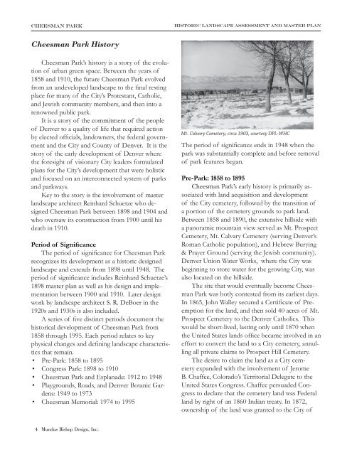
Mt. Calvary Cemetery, circa 1903, courtesy DPL-WHC<br />
The period <strong>of</strong> signifi cance ends in 1948 when the<br />
park was substantially complete <strong>and</strong> before removal<br />
<strong>of</strong> park features began.<br />
Pre-<strong>Park</strong>: 1858 to 1895<br />
Cheesman <strong>Park</strong>’s early history is primarily associated<br />
with l<strong>and</strong> acquisition <strong>and</strong> development<br />
<strong>of</strong> the <strong>City</strong> cemetery, followed by the transition <strong>of</strong><br />
a portion <strong>of</strong> the cemetery grounds to park l<strong>and</strong>.<br />
Between 1858 <strong>and</strong> 1890, the extensive hillside with<br />
a panoramic mountain view served as Mt. Prospect<br />
Cemetery, Mt. Calvary Cemetery (serving <strong>Denver</strong>’s<br />
Roman Catholic population), <strong>and</strong> Hebrew Burying<br />
& Prayer Ground (serving the Jewish community).<br />
<strong>Denver</strong> Union Water Works, where the <strong>City</strong> was<br />
beginning to store water for the growing <strong>City</strong>, was<br />
also located on the hillside.<br />
The site that would eventually become Cheesman<br />
<strong>Park</strong> was hotly contested from its earliest days.<br />
In 1865, John Walley secured a Certifi cate <strong>of</strong> Preemption<br />
for the l<strong>and</strong>, <strong>and</strong> then sold 40 acres <strong>of</strong> Mt.<br />
Prospect Cemetery to the <strong>Denver</strong> Catholics. This<br />
would be short-lived, lasting only until 1870 when<br />
the United States l<strong>and</strong>s <strong>of</strong>fi ce became involved in an<br />
effort to convert the l<strong>and</strong> to a <strong>City</strong> cemetery, annulling<br />
all private claims to Prospect Hill Cemetery.<br />
The desire to claim the l<strong>and</strong> as a <strong>City</strong> cemetery<br />
exp<strong>and</strong>ed with the involvement <strong>of</strong> Jerome<br />
B. Chaffee, Colorado’s Territorial Delegate to the<br />
United States Congress. Chaffee persuaded Congress<br />
to declare that the cemetery l<strong>and</strong> was Federal<br />
l<strong>and</strong> by right <strong>of</strong> an 1860 Indian treaty. In 1872,<br />
ownership <strong>of</strong> the l<strong>and</strong> was granted to the <strong>City</strong> <strong>of</strong>
Cheesman <strong>Park</strong><br />
<strong>Denver</strong> in the form <strong>of</strong> a l<strong>and</strong> patent that was issued<br />
to <strong>Denver</strong> Mayor Joseph E. Bates for 160 acres <strong>of</strong><br />
l<strong>and</strong> at $1.25 an acre ($200 total) for cemetery uses<br />
‘in perpetuity.’<br />
During these early years, <strong>City</strong> planning in <strong>Denver</strong><br />
was also well underway. Three notable comprehensive<br />
<strong>City</strong> plans were developed between 1858<br />
<strong>and</strong> 1895, including the 1859 Surveyors Block Plan<br />
<strong>and</strong> the 1878 Sopris Lee Plan.<br />
The most comprehensive plan was created by<br />
John Evans, Colorado’s second territorial governor,<br />
with the help <strong>of</strong> Edward Roll<strong>and</strong>et, Chief Draftsman<br />
for <strong>Denver</strong>’s Department <strong>of</strong> Public Works.<br />
Evans’ remarkable 1894 plan proposed a Capitol<br />
Hill <strong>Park</strong> encompassing the entire 160-acre site<br />
<strong>of</strong> the cemetery grounds <strong>and</strong> the <strong>Denver</strong> Union<br />
Water Works l<strong>and</strong>. The park was to be connected<br />
to the greater park system by a series <strong>of</strong> boulevards<br />
including York Street on the east (that would have<br />
run north-south through the park), 10th Avenue to<br />
the west <strong>and</strong> Franklin Street to the north that connected<br />
to <strong>Park</strong> Avenue.<br />
Evans’ plan was the fi rst comprehensive framework<br />
for a <strong>City</strong>-wide parks <strong>and</strong> boulevards system,<br />
HISTORIC l<strong>and</strong>scape ASSESSMENT AND Master Plan<br />
predating Mayor Speer’s <strong>City</strong> Beautiful plan by more<br />
than ten years. Evans’ proposal was the subject <strong>of</strong><br />
great opposition <strong>and</strong> controversy, but was eventually<br />
adopted by <strong>Denver</strong>’s <strong>City</strong> Council. A few components<br />
<strong>of</strong> the plan were built—<strong>Park</strong> Avenue being<br />
the most signifi cant. However, the plan raised<br />
awareness about the importance <strong>of</strong> a comprehensive<br />
park system, including the proposal for a <strong>City</strong><br />
park on the former cemetery grounds.<br />
During the 1880s, the <strong>City</strong> <strong>of</strong> <strong>Denver</strong> was rapidly<br />
growing, particularly along its eastern edges. In<br />
the late 1880s, streets <strong>and</strong> alleys were laid out north<br />
<strong>of</strong> the cemetery grounds <strong>and</strong> residential lots were<br />
sold. As residents began to populate the surrounding<br />
neighborhood, the desire for public open space<br />
grew. Lack <strong>of</strong> irrigation water <strong>and</strong> the poor, unsightly<br />
appearance <strong>of</strong> the cemetery led neighbors<br />
<strong>and</strong> l<strong>and</strong>owners to champion moving the cemetery<br />
to newly opened Riverside Cemetery, on the Platte<br />
River north <strong>of</strong> downtown <strong>Denver</strong>. In 1890, Congress<br />
assisted again at the recommendation <strong>of</strong><br />
Colorado Senator Henry Teller, decreeing that <strong>City</strong><br />
Cemetery be converted to <strong>City</strong> parkl<strong>and</strong>.<br />
Pre-<strong>Park</strong>: 1858 to 1895<br />
Mundus Bishop Design, Inc. 5
Cheesman <strong>Park</strong><br />
6<br />
Mundus Bishop Design, Inc.<br />
HISTORIC l<strong>and</strong>scape ASSESSMENT AND Master Plan<br />
W<br />
N<br />
S<br />
E<br />
Congress <strong>Park</strong>: 1898 to 1910
Cheesman <strong>Park</strong><br />
Congress <strong>Park</strong>: 1898 to 1910<br />
As the l<strong>and</strong> acquisition was completed <strong>and</strong> the<br />
task <strong>of</strong> moving the graves began, efforts turned to<br />
designing the new <strong>City</strong> park. The park was initially<br />
known as Congress <strong>Park</strong>, named in recognition <strong>of</strong><br />
the efforts by the United States Congress in deeding<br />
the l<strong>and</strong> to <strong>Denver</strong>. The design <strong>and</strong> construction<br />
<strong>of</strong> the park <strong>and</strong> the majority <strong>of</strong> its features<br />
occurred between the years <strong>of</strong> 1898 <strong>and</strong> 1910<br />
under the direction <strong>of</strong> the <strong>City</strong>’s l<strong>and</strong>scape architect<br />
Reinhard Schuetze. Two plans by Schuetze were<br />
instrumental in setting the design direction for<br />
Congress <strong>Park</strong>: one plan completed in 1898 <strong>and</strong> the<br />
other developed between 1898 <strong>and</strong> 1902.<br />
Schuetze’s initial park design is documented<br />
as the “Plan for Congress <strong>Park</strong> 1898.” Schuetze<br />
was a master in the design <strong>of</strong> public space having<br />
designed the grounds <strong>of</strong> Fairmount Cemetery in<br />
1893 <strong>and</strong> the Colorado State Capitol Grounds in<br />
1895. Schuetze was also in the process <strong>of</strong> designing<br />
Washington <strong>Park</strong> in 1899, <strong>and</strong> was modifying<br />
the design <strong>of</strong> <strong>City</strong> <strong>Park</strong> with his proposal for Ferril<br />
Lake.<br />
Schuetze’s 1898 park plan proposed a series <strong>of</strong><br />
open lawns <strong>and</strong> enclosed spaces organized along an<br />
HISTORIC l<strong>and</strong>scape ASSESSMENT AND Master Plan<br />
Schuetze’s original 1898 park plan, courtesy DPL-WHC<br />
Schuetze’s 1902 park plan, courtesy DPL-WHC<br />
Mundus Bishop Design, Inc. 7
Cheesman <strong>Park</strong><br />
8<br />
LEGEND<br />
3<br />
4<br />
b<br />
c<br />
5<br />
2<br />
6 d e<br />
7<br />
VEHICULAR ENTRANCE<br />
PEDESTRIAN ENTRANCE<br />
UNTER DEN LINDEN<br />
W<br />
AXIS<br />
MAJOR PARK SPACE<br />
<strong>Park</strong> Composition Analysis - 1898 to 1910<br />
N<br />
SECONDARY PARK SPACE<br />
Mundus Bishop Design, Inc.<br />
S<br />
E<br />
a<br />
1<br />
f<br />
9<br />
8<br />
HISTORIC l<strong>and</strong>scape ASSESSMENT AND Master Plan<br />
hourglass-shaped park road. The park road connected<br />
to surrounding neighborhood streets <strong>and</strong> to<br />
Franklin Street, which defi ned the park’s western<br />
edge. Schuetze’s original proposal was to create<br />
a park fronted on all four sides by neighborhood<br />
streets. Key elements in the plan included a large<br />
formal pavilion situated on the east on the hilltop<br />
<strong>and</strong> a smaller more informal park space on the<br />
west.<br />
Between 1898 <strong>and</strong> 1902, Schuetze continued<br />
to refi ne this earlier vision, retaining a very similar<br />
park composition but enlarging the park plan as<br />
the boundaries <strong>of</strong> the site had broadened. The<br />
1902 Plan set the park boundaries that remain today—between<br />
East 8th Avenue to almost East 13th<br />
Avenue, <strong>and</strong> from the alley between Humboldt <strong>and</strong><br />
Franklin Streets to the alley between High <strong>and</strong> Race<br />
Street. This arrangement differs from Schuetze’s<br />
original design for a four-sided park, as the northern,<br />
western <strong>and</strong> eastern edges <strong>of</strong> the park were<br />
residential lots that would eventually accommodate<br />
large prestigious homes.<br />
Schuetze organized the park composition along<br />
an axis line that extended from the northeast to the<br />
southwest. He chose to slightly skew the orientation<br />
<strong>of</strong> the park along this axis line, rather than<br />
along the <strong>City</strong> grid, to create an illusion <strong>of</strong> a larger<br />
open space. The park is further articulated by the<br />
sinuous, hourglass-shaped interior park road that<br />
defi ned two expansive open lawns <strong>and</strong> two smaller<br />
park spaces.<br />
Construction under Schuetze’s direction began<br />
in 1900 with the grading <strong>of</strong> the park road, repairing<br />
<strong>of</strong> fences, <strong>and</strong> the opening <strong>of</strong> High Street <strong>and</strong> 12th<br />
Avenue through Congress <strong>Park</strong>.<br />
As construction continued, Franklin Street became<br />
the western park edge, extending from East<br />
13th Avenue to East 8th Avenue. Franklin Street<br />
was lined with four rows <strong>of</strong> American Linden trees,<br />
allegedly ordered planted by Mayor Speer in 1907.<br />
The distinct double allee <strong>of</strong> shade trees was patterned<br />
after Berlin’s Unter den Linden translated as,<br />
“under the Linden trees.” The park was connected<br />
to the surrounding growing neighborhood by nine<br />
vehicular entries <strong>and</strong> six pedestrian only paths.
Cheesman <strong>Park</strong><br />
Schuetze crafted the park topography to articulate<br />
these key l<strong>and</strong>scape spaces. The smaller more<br />
detailed spaces are sited symmetrically across from<br />
one another along the axis line, one to the southeast<br />
<strong>and</strong> the other to the northwest. On the east,<br />
Schuetze used the naturally high ground, accentuating<br />
the topography to create a platform in which he<br />
could position a formal garden <strong>and</strong> a comm<strong>and</strong>ing<br />
‘viewpoint’ to serve as both visual icon for the park<br />
<strong>and</strong> to provide an expansive view <strong>of</strong> the Rocky<br />
Mountains.<br />
The park space to the west was designed in<br />
an informal manner with a naturalistic lily pond,<br />
built as “an excavation. . .for a shallow lake covering 1½<br />
acres to be fi lled with water lilies” as its focus. A fl uid<br />
system <strong>of</strong> paths <strong>and</strong> trails moved throughout the<br />
park. Groves <strong>of</strong> evergreen <strong>and</strong> deciduous shade<br />
trees dotted the park road, noting small intimate<br />
park spaces <strong>and</strong> providing shade. Plantings along<br />
the park edges defi ned the open space, separating<br />
it from the adjacent residences. Schuetze’s original<br />
composition remained generally intact until the late<br />
1940s <strong>and</strong> early 1950s, when park features <strong>and</strong> elements<br />
began to be removed from the park.<br />
Planting began in earnest in 1902, when shrubs<br />
were planted <strong>and</strong> preparations for seeding the north<br />
half <strong>of</strong> park were made, including fi lling c<strong>of</strong>fi n<br />
holes from the earlier cemetery. Notes on the 1902<br />
plan indicate that “2,000 trees <strong>and</strong> shrubs will be set out<br />
<strong>and</strong> some grass sown. Next year it is hoped that the board<br />
will be in better fi nancial shape <strong>and</strong> a greater portion <strong>of</strong> the<br />
ambitious plans will be executed.”<br />
By 1905, more plants were ordered, <strong>and</strong> in<br />
1906 the Rustic Shelter, the <strong>Park</strong>’s fi rst structure,<br />
was built. Schuetze designed the Rustic Shelter<br />
in the naturalistic rustic style. It is a small, round<br />
wooden structure with a broad overhanging ro<strong>of</strong><br />
<strong>and</strong> a wood bench that encircles most <strong>of</strong> the entire<br />
structure. It was built <strong>of</strong> h<strong>and</strong>- turned elm logs<br />
with detailed railings <strong>and</strong> sited in the northern half<br />
<strong>of</strong> the park. The Rustic Shelter was restored to its<br />
original form <strong>and</strong> condition in April 2006.<br />
HISTORIC l<strong>and</strong>scape ASSESSMENT AND Master Plan<br />
<strong>Park</strong> view, circa 1909, courtesy DPL-WHC<br />
Rustic shelter designed by Reinhard Schuetze, circa 1907,<br />
courtesy <strong>Denver</strong> Municipal Facts<br />
Mundus Bishop Design, Inc. 9
Cheesman <strong>Park</strong><br />
Aerial Views, circa 1910, courtesy DPL -WHC<br />
10 Mundus Bishop Design, Inc.<br />
HISTORIC l<strong>and</strong>scape ASSESSMENT AND Master Plan
Cheesman <strong>Park</strong><br />
A distinctive <strong>and</strong> iconic pavilion, envisioned as<br />
early as 1898 by Reinhard Schuetze, became a reality<br />
after Mayor Speer secured private funding in the<br />
amount <strong>of</strong> $100,000 from the Walter Cheesman<br />
family to commemorate Mr. Cheesman who passed<br />
away in 1907. To acknowledge the family’s generous<br />
gift, Mayor Speer with the approval <strong>of</strong> <strong>City</strong> Council<br />
renamed Congress <strong>Park</strong> to Cheesman <strong>Park</strong> <strong>and</strong><br />
named the future pavilion the Cheesman Memorial.<br />
With funding in place in 1907, Mayor Speer commissioned<br />
the renowned l<strong>and</strong>scape architect George<br />
Kessler from Kansas <strong>City</strong> to design the formal<br />
gardens, <strong>and</strong> the architectural fi rm <strong>of</strong> Marean <strong>and</strong><br />
Norton to design a neoclassical pavilion.<br />
At the time, Kessler was working with Speer on<br />
the creation <strong>of</strong> the <strong>Denver</strong> parks <strong>and</strong> parkway system<br />
that included Cheesman <strong>Park</strong> as a key element.<br />
Kessler connected the park to the overall system<br />
by a series <strong>of</strong> parkways. To the north, he identifi ed<br />
Franklin Street as a parkway, connecting to the existing<br />
<strong>Park</strong> Avenue at Colfax Avenue. Using the<br />
interior road <strong>of</strong> Cheesman <strong>Park</strong> as a parkway, Kessler<br />
connected to the parkway system to the south<br />
along Williams Street, twisting it through the newly<br />
developed Country Club subdivision to connect to<br />
Washington <strong>Park</strong>.<br />
Following the tradition <strong>of</strong> the <strong>City</strong> Beautiful principles<br />
<strong>of</strong> symmetry, beauty <strong>and</strong> grace, Marean <strong>and</strong><br />
Norton Architects designed a neoclassical outdoor<br />
pavilion as an icon set on the highest point in the<br />
park, to be experienced from below as an object in<br />
space with blue sky behind. Completed in 1910, the<br />
Cheesman Memorial overlooked the park <strong>and</strong> most<br />
<strong>of</strong> the <strong>City</strong> to the north, south <strong>and</strong> west. It was<br />
silhouetted on the east by a backdrop <strong>of</strong> evergreen<br />
trees. Today, the Memorial remains visible from<br />
most points in the park <strong>and</strong> continues to serve as a<br />
reference point <strong>and</strong> a beacon at night.<br />
By 1910, the alignment, length <strong>and</strong> role <strong>of</strong><br />
Franklin Street changed dramatically. The straight<br />
north-south route along Franklin Street was eliminated<br />
<strong>and</strong> the road was realigned to connect to the<br />
interior park road. The Franklin Street roadway that<br />
had once been a <strong>City</strong> street <strong>and</strong> a key connection in<br />
the <strong>Denver</strong> parks <strong>and</strong> parkway was converted into<br />
a green lawn that extended for most <strong>of</strong> the park’s<br />
length.<br />
HISTORIC l<strong>and</strong>scape ASSESSMENT AND Master Plan<br />
Kessler Plan, circa 1907, courtesy <strong>Denver</strong> Municipal Facts<br />
Cheesman Memorial, circa 1910, courtesy DPL-WHC<br />
Mundus Bishop Design, Inc. 11
Cheesman <strong>Park</strong><br />
12 Mundus Bishop Design, Inc.<br />
HISTORIC l<strong>and</strong>scape ASSESSMENT AND Master Plan<br />
W<br />
N<br />
E<br />
S<br />
Cheesman <strong>Park</strong>: 1912 to 1948
Cheesman <strong>Park</strong><br />
Cheesman <strong>Park</strong> <strong>and</strong> Esplanade: 1912 to 1948<br />
Reinhard Schuetze’s death in 1910 ended an era<br />
<strong>of</strong> creative <strong>and</strong> thoughtful park design in <strong>Denver</strong>.<br />
Fortunately, Cheesman <strong>Park</strong> was substantially<br />
complete <strong>and</strong> for the next 36 years would remain as<br />
Scheutze intended with only minor changes. This<br />
same year, S.R. DeBoer was hired by the <strong>City</strong> as a<br />
park employee.<br />
S. R. DeBoer eventually took over the duties <strong>of</strong><br />
<strong>City</strong> l<strong>and</strong>scape architect. For Cheesman <strong>Park</strong>, De-<br />
Boer oversaw the conversion <strong>of</strong> Franklin Street to<br />
a pedestrian space <strong>and</strong> referred to Cheesman <strong>Park</strong>’s<br />
western edge as the ‘pedestrian mall.’ The site <strong>and</strong><br />
planting design <strong>of</strong> this space is DeBoer’s primary<br />
contribution to the design <strong>of</strong> Cheesman <strong>Park</strong>.<br />
Thought to have occurred before 1920, DeBoer’s<br />
design <strong>of</strong> plantings <strong>and</strong> walkways at both the north<br />
<strong>and</strong> south ends transformed the Franklin Street<br />
alignment into a clearly defi ned park space.<br />
1<br />
2<br />
On the north, DeBoer created an entry space<br />
along the Franklin Street road by adding new<br />
trees that transformed the existing American<br />
Linden allee into a grove.<br />
To the south, he created a small park space<br />
using a pedestrian path <strong>and</strong> an open lawn, eras-<br />
ing the southern portion <strong>of</strong> the original road<br />
way. DeBoer planted groves <strong>of</strong> trees <strong>and</strong><br />
shrub masses at the southern end <strong>of</strong> the<br />
pedestrian mall. This established both spaces,<br />
the pedestrian mall <strong>and</strong> the small l<strong>and</strong>scape<br />
space, as credible park elements.<br />
DeBoer’s plantings on the park’s western edge created<br />
a frame for the larger open lawns <strong>and</strong> provided<br />
a clear sense <strong>of</strong> entry into the park at East 12th <strong>and</strong><br />
East 9th Avenues. His understory plantings provided<br />
a s<strong>of</strong>t edge to the park’s boundary.<br />
Additional park improvements occurred after<br />
1912, including the addition <strong>of</strong> wading pools at the<br />
Cheesman Memorial at its western stairs <strong>and</strong> garden<br />
beds on its east side. The garden beds were removed<br />
at a later time. The Portl<strong>and</strong> Cement Company<br />
donated drinking fountains that were placed at<br />
HISTORIC l<strong>and</strong>scape ASSESSMENT AND Master Plan<br />
the northern <strong>and</strong> southern ends <strong>of</strong> the Pavilion.<br />
Grass was planted to East 8th Avenue, trees<br />
were planted on the north, south, <strong>and</strong> southeast<br />
sides <strong>of</strong> the park, <strong>and</strong> the pedestrian path at<br />
East 10th Avenue was extended.<br />
LEGEND<br />
3<br />
4<br />
b<br />
c<br />
5<br />
2<br />
1<br />
VEHICULAR ENTRANCE<br />
PEDESTRIAN ENTRANCE<br />
UNTER DEN LINDEN<br />
VISUAL CONNECTION<br />
2<br />
AXIS<br />
6 d e<br />
7<br />
W<br />
MAJOR PARK SPACE<br />
SECONDARY PARK SPACE<br />
N<br />
E<br />
a<br />
S<br />
<strong>Park</strong> Composition Analysis: 1912-1948<br />
1<br />
f<br />
9<br />
8<br />
Mundus Bishop Design, Inc. 13
Cheesman <strong>Park</strong><br />
Parade, circa 1920, courtesy DPL-WHC<br />
Cheesman <strong>Park</strong> vista, circa 1920, courtesy DPL-WHC<br />
Cheesman Memorial, circa 1910, courtesy DPL-WHC<br />
14 Mundus Bishop Design, Inc.<br />
HISTORIC l<strong>and</strong>scape ASSESSMENT AND Master Plan<br />
In 1912, Cheesman <strong>Park</strong> served as a temporary<br />
shelter for victims <strong>of</strong> the major Cherry Creek fl ood<br />
that inundated neighborhoods along the river <strong>and</strong><br />
displaced residents including some from the nearby<br />
Country Club area. The Cheesman Memorial<br />
served a similar purpose 21 years later in August <strong>of</strong><br />
1933 when Cherry Creek fl ooded once again after<br />
the collapse <strong>of</strong> the Castlewood Canyon dam.<br />
In 1913, the Colorado Mountain Club donated<br />
the Mountain Index. It is placed on the west terrace<br />
<strong>of</strong> the Cheesman Memorial.<br />
Beginning in 1911, the Olmsted Brothers l<strong>and</strong>scape<br />
architectural fi rm <strong>of</strong> Brookline, Massachusetts,<br />
was commissioned to design <strong>Denver</strong>’s parks,<br />
parkways, <strong>and</strong> the <strong>City</strong>’s <strong>Denver</strong> Mountain <strong>Park</strong>s<br />
system. Their commission included the Cheesman<br />
Esplanade, also known as Little Cheesman, to the<br />
south <strong>of</strong> Cheesman <strong>Park</strong> as part <strong>of</strong> their design for<br />
the Williams Street <strong>Park</strong>way.<br />
Completed in 1914, the Cheesman Esplanade<br />
was a formal design. Its key element was a symmetrical<br />
space, arranged in a linear pattern in alignment<br />
with the center line <strong>of</strong> the Cheesman Memorial.<br />
The Cheeseman Esplanade consisted <strong>of</strong> three<br />
distinct areas—two enclosed terraces, on the north<br />
<strong>and</strong> south ends, connected by a linear walkway lined<br />
by Downy Hawthorne trees. The two terraces were<br />
enclosed by dense evergreen tree plantings with<br />
a small ‘window’ opening to the north to visually<br />
connect with the Memorial. The space was also<br />
arranged symmetrically along a secondary axis in<br />
the center <strong>of</strong> the Esplanade that was oriented east<br />
to west. The western two-thirds <strong>of</strong> the Esplanade<br />
consisted <strong>of</strong> a broad, sloping lawn.<br />
Between 1929 <strong>and</strong> 1935, Cheesman <strong>Park</strong> served<br />
as an outdoor venue for lectures <strong>and</strong> concerts. The<br />
<strong>Denver</strong> Post’s outdoor university brought <strong>Denver</strong>ites<br />
to the park for summer lectures. By 1934,<br />
the <strong>Denver</strong> Post had exp<strong>and</strong>ed its lecture series to<br />
include the Post Opera, using the Pavilion as their<br />
stage <strong>and</strong> the south lawn for seating. The project<br />
was made possible by the efforts <strong>of</strong> Helen Bonfi ls.<br />
It enjoyed a two week run <strong>and</strong> attracted an audience<br />
totaling 20,000 people. The last summer <strong>of</strong> the<br />
outdoor university was 1935.
Cheesman <strong>Park</strong><br />
Aerial View <strong>of</strong> Cheesman Memorial, 1912, courtesy DPL-WHC<br />
Aerial View <strong>of</strong> Cheesman Memorial, 1912, courtesy DPL-WHC<br />
View <strong>of</strong> Mt Evans, from Cheesman Memorial, circa 1912,<br />
courtesy DPL-WHC<br />
HISTORIC l<strong>and</strong>scape ASSESSMENT AND Master Plan<br />
Olmsted Brothers’ Esplanade Plan, 1914, courtesy DPL-WHC<br />
“The eastern portion <strong>of</strong> the block should be treated in a formal way, the treatment<br />
should be balanced about an axis in effect is a continuation <strong>of</strong> the axis <strong>of</strong> the Cheesman<br />
Memorial, although not an exact continuation <strong>of</strong> the center line <strong>of</strong> the building. Upon this<br />
axis we have proposed a series <strong>of</strong> three terraces: a square near 8th Avenue, to be kept high;<br />
a long narrow panel in the center to slope parallel to High Street; <strong>and</strong> a square near 7th<br />
Avenue, to be practically on a level with High Street at the center, but considerably above<br />
the level <strong>of</strong> 7th Avenue.” Correspondence from Frederick Law Olmsted Jr. to<br />
<strong>Park</strong> Superintendent. Courtesy library <strong>of</strong> congress.<br />
Mundus Bishop Design, Inc. 15
Cheesman <strong>Park</strong><br />
Parade, circa 1920<br />
16 Mundus Bishop Design, Inc.<br />
HISTORIC l<strong>and</strong>scape ASSESSMENT AND Master Plan<br />
W<br />
N<br />
S<br />
E<br />
Cheesman <strong>Park</strong>: 1949 to 1973
Cheesman <strong>Park</strong><br />
Playgrounds, Roads,<br />
<strong>and</strong> <strong>Denver</strong> Botanic Gardens: 1949 to 1973<br />
Cheesman <strong>Park</strong> was generally complete by 1914<br />
when construction <strong>of</strong> the Esplanade was fi nished.<br />
The park composition <strong>and</strong> its key contributing features<br />
remained intact until the late 1940s <strong>and</strong> early<br />
1950s.<br />
Beginning in 1949 <strong>and</strong> continuing into the 1970s,<br />
many modifi cations were made to the park road<br />
<strong>and</strong> many trails were removed. In 1949, street<br />
lighting was added to the edges <strong>of</strong> the park road<br />
to improve safety <strong>and</strong> security. Although, the light<br />
pole <strong>and</strong> fi xture were utilitarian in design <strong>and</strong> were<br />
not necessarily intended to be aesthetic improvements,<br />
they were compatible with the park’s character.<br />
Several original street lights remain in the park.<br />
Changes to the park road also included widening,<br />
<strong>and</strong> the addition <strong>of</strong> a concrete curb, mow strips <strong>and</strong><br />
street washers. In 1958, a row <strong>of</strong> head-in parking<br />
for 29 cars was added to the west edge <strong>of</strong> the park<br />
road immediately in front <strong>of</strong> the Pavilion <strong>and</strong> the<br />
roadway was widened to 32 feet. On the east side,<br />
small parking areas on each side <strong>of</strong> the garden were<br />
exp<strong>and</strong>ed <strong>and</strong> paved in asphalt, resulting in an additional<br />
39 parking spaces that extended from end<br />
to end <strong>of</strong> the terrace.<br />
By 1958, most <strong>of</strong> the interior park trails had been<br />
removed. Only one <strong>of</strong> the linear paths in the Unter<br />
den Linden, paths around the pavilion, paths leading<br />
into the park from East 8th Avenue, <strong>and</strong> paths<br />
around the playground on the west side remained.<br />
The path to the Rustic Shelter was removed, making<br />
it seem out <strong>of</strong> place in the broad lawn. All <strong>of</strong><br />
the paths <strong>and</strong> the two terraces in the Cheesman<br />
Esplanade were removed by this time as well.<br />
The park’s fi rst play areas were added in the early<br />
1950s, including the initial playground <strong>of</strong> 1950 on<br />
the west side <strong>of</strong> the park near the East 10th Avenue<br />
pedestrian entrance <strong>and</strong> set near the eastern edge <strong>of</strong><br />
the Unter den Linden. The playground was designed<br />
by S. R. DeBoer in a free-form arrangement<br />
that was popular at the time.<br />
DeBoer sited the playground within a shady grove<br />
<strong>of</strong> trees with its eastern boundary defi ned by a row<br />
<strong>of</strong> evergreens. It included two types <strong>of</strong> swings,<br />
HISTORIC l<strong>and</strong>scape ASSESSMENT AND Master Plan<br />
LEGEND<br />
3<br />
4<br />
b<br />
c<br />
5<br />
2<br />
6 d e<br />
7<br />
VEHICULAR ENTRANCE<br />
PEDESTRIAN ENTRANCE<br />
UNTER DEN LINDEN<br />
W<br />
AXIS<br />
MAJOR PARK SPACE<br />
N<br />
<strong>Park</strong> Composition Analysis: 1949-1973<br />
a<br />
SECONDARY PARK SPACE<br />
S<br />
E<br />
1<br />
9<br />
8<br />
Mundus Bishop Design, Inc. 17<br />
f<br />
10
Cheesman <strong>Park</strong><br />
a Miracle Wheel (merry-go-round), a ten foot<br />
tall Climb Around, teeter-totters, a 12-foot tall<br />
metal slide <strong>and</strong> several s<strong>and</strong> pits, one <strong>of</strong> which<br />
encircled an American Elm. The playground<br />
appears to have been surrounded by a fence.<br />
In 1952, DeBoer designed a Tot Lot, which<br />
he intended to be built just to the west <strong>of</strong> the<br />
Unter den Linden <strong>and</strong> adjacent to the park’s<br />
western border. It was larger than the original<br />
playground <strong>and</strong> more interesting in design as it<br />
included a series <strong>of</strong> small spaces separated by<br />
hedges <strong>and</strong> lawn. Each space accommodated a<br />
piece <strong>of</strong> play equipment <strong>and</strong> benches for observation.<br />
The Tot Lot was never built.<br />
18 Mundus Bishop Design, Inc.<br />
HISTORIC l<strong>and</strong>scape ASSESSMENT AND Master Plan<br />
Signifi cant changes occurred east <strong>of</strong> Cheesman<br />
<strong>Park</strong> in the mid to late 1950s when the <strong>City</strong><br />
acquired the l<strong>and</strong> occupied by the Mount Calvary<br />
Cemetery to develop the <strong>Denver</strong> Botanic Gardens.<br />
The grounds were designed in 1958 <strong>and</strong> were<br />
laid out as a series <strong>of</strong> varied gardens along a path<br />
oriented along the center axis <strong>of</strong> the Cheesman<br />
Memorial, visually connecting the new gardens with<br />
Cheesman <strong>Park</strong>.<br />
Ruth Waring donated her home at East 9th<br />
Avenue <strong>and</strong> York Street in 1959 for use as <strong>of</strong>fi ces<br />
for the Botanic Gardens headquarters. In 1963, the<br />
Boettcher family awarded the Botanic Gardens a<br />
grant <strong>of</strong> $600,000 for a new conservatory, designed<br />
by renowned architects Victor Hornbein <strong>and</strong> Ed<br />
White, <strong>and</strong> dedicated in 1966.<br />
Road <strong>and</strong> parking changes at Cheesman Memorial, 1958 Plan, courtesy <strong>Denver</strong> <strong>Park</strong>s & Recreation
Cheesman <strong>Park</strong><br />
The development <strong>of</strong> the gardens continued with<br />
the construction <strong>of</strong> the Education Building in 1969,<br />
also designed by Victor Hornbein <strong>and</strong> funded by a<br />
$500,000 grant from the Boettcher family. In 1970,<br />
the l<strong>and</strong>scape architectural fi rm <strong>of</strong> EDAW was<br />
commissioned to design a master plan to further<br />
the development <strong>of</strong> the grounds. The EDAW plan<br />
exp<strong>and</strong>ed upon the original grounds, retaining the<br />
alignment <strong>of</strong> the main path along the center axis <strong>of</strong><br />
the Pavilion.<br />
The mountain views from the Cheesman<br />
Memorial were key elements <strong>of</strong> the Pavilion’s<br />
original design, <strong>and</strong> continue to be loved by park<br />
users, especially for sunset viewing. In the mid-<br />
1960s these mountain views were threatened by the<br />
proposed development <strong>of</strong> a high-rise apartment<br />
building on the park’s western edge. The developer<br />
<strong>and</strong> local residents disagreed over the building <strong>of</strong><br />
Cheesman Gardens at East 10th Avenue, ultimately<br />
engaging the <strong>City</strong> in a legal battle with the developer.<br />
The <strong>City</strong> had issued a foundation permit,<br />
which the developer argued indicated <strong>City</strong> approval<br />
to build the high-rise building. In 1968, the court<br />
upheld the developer’s right to construct the building.<br />
That same year, the residents, including the<br />
founder <strong>of</strong> the <strong>Denver</strong> L<strong>and</strong>mark Preservation<br />
Commission Helen Arndt; Dana Crawford; <strong>and</strong><br />
architect James Sudler worked to secure a view<br />
plane ordinance to prevent any further construction<br />
on the park’s western edge. Ordinance No. 260,<br />
protecting the views from the Cheesman Memorial,<br />
received <strong>City</strong> Council approval in 1968.<br />
HISTORIC l<strong>and</strong>scape ASSESSMENT AND Master Plan<br />
Cheesman <strong>Park</strong>, aerial view circa 1958,<br />
courtesy <strong>Denver</strong> <strong>Park</strong>s & Recreation<br />
Mundus Bishop Design, Inc. 19
Cheesman <strong>Park</strong><br />
20 Mundus Bishop Design, Inc.<br />
HISTORIC l<strong>and</strong>scape ASSESSMENT AND Master Plan<br />
W<br />
N<br />
S<br />
E<br />
Cheesman <strong>Park</strong>: 1974 to 1995
Cheesman <strong>Park</strong><br />
Cheesman Memorial: 1974 to 1995<br />
Beginning in the mid-1970s, several major<br />
changes were made to Cheesman <strong>Park</strong> to remediate<br />
deterioration <strong>of</strong> park features, to solve confl icts,<br />
<strong>and</strong> to bring the park into a modern aesthetic. It is<br />
likely that the intent <strong>of</strong> these modifi cations were to<br />
enhance <strong>and</strong> improve the park, but ultimately these<br />
changes would have a long lasting effect that would<br />
damage its historic integrity <strong>and</strong> be hard to reverse.<br />
These Modifi cations included major site <strong>and</strong><br />
building changes at the Cheesman Memorial, <strong>and</strong><br />
the removal <strong>of</strong> the central segment <strong>of</strong> the hourglass<br />
road. <strong>Park</strong> design in the 1970s was changing as<br />
well. The trend was toward less formal <strong>and</strong> more<br />
organic spaces. Open sloping lawns <strong>and</strong> geometric<br />
patterns were popular.<br />
At the time, the Cheesman Memorial was in poor<br />
condition. Its balustrade, staircases, water fountains,<br />
<strong>and</strong> building walls were deteriorating <strong>and</strong> its<br />
ro<strong>of</strong> needed repair. The Pavilion’s historic marble<br />
<strong>and</strong> concrete elements, particularly those outside<br />
the walls <strong>of</strong> the building, such as the balustrade<br />
with its carved posts <strong>and</strong> cap rail, were considered<br />
too expensive to be repaired <strong>and</strong> replaced.<br />
To renovate the Pavilion, the <strong>City</strong> along with<br />
its non-pr<strong>of</strong>i t partner, The <strong>Park</strong> People, chose to<br />
remove the balustrade in its entirety. They also<br />
removed the formal staircases, a portion <strong>of</strong> the<br />
lower garden, <strong>and</strong> the terrace fountains. In place <strong>of</strong><br />
the balustrade, a sloping lawn was laid against (<strong>and</strong><br />
obscured) the original Pavilion walls. The ro<strong>of</strong> was<br />
repaired, the marble was washed, <strong>and</strong> the site was<br />
planted with a variety <strong>of</strong> trees to ‘s<strong>of</strong>ten’ the pavilion.<br />
The restrooms were closed.<br />
The road in front <strong>of</strong> the Pavilion was narrowed<br />
to 24 feet <strong>and</strong> the parking was removed. The parking<br />
<strong>and</strong> the drive behind the Pavilion were also<br />
removed. The drive was replaced by an eight foot<br />
wide bicycle trail that did not connect to the park<br />
trail system. Two new parking lots, located to the<br />
north <strong>and</strong> south <strong>of</strong> the Pavilion, were added to<br />
HISTORIC l<strong>and</strong>scape ASSESSMENT AND Master Plan<br />
LEGEND<br />
3<br />
4<br />
b<br />
c<br />
5<br />
2<br />
6 d e<br />
7<br />
VEHICULAR ENTRANCE<br />
PEDESTRIAN ENTRANCE<br />
UNTER DEN LINDEN<br />
VISUAL CONNECTION<br />
W<br />
AXIS<br />
MAJOR PARK SPACE<br />
N<br />
a<br />
SECONDARY PARK SPACE<br />
S<br />
E<br />
1<br />
9<br />
8<br />
Mundus Bishop Design, Inc. 21<br />
f<br />
10<br />
<strong>Park</strong> Composition Analysis: 1974-1995
Cheesman <strong>Park</strong><br />
serve the Pavilion. The northern lot held 24<br />
spaces <strong>and</strong> the southern lot had 39 spaces. Concrete<br />
retaining walls were added to the terraces<br />
at both the northern <strong>and</strong> southern ends <strong>of</strong> the<br />
Pavilion.<br />
East <strong>of</strong> the Pavilion, a new gatehouse structure<br />
for the <strong>Denver</strong> Botanic Gardens was built,<br />
intentionally sited slightly <strong>of</strong>f-center to allow for<br />
a clear <strong>and</strong> unobstructed view between the two<br />
spaces. This view did not last. Soon after, the<br />
<strong>Denver</strong> Botanic Garden’s Japanese Garden was<br />
installed <strong>and</strong> blocked the view.<br />
In Cheesman <strong>Park</strong>, a new walkway, memorial<br />
tree monument <strong>and</strong> annual fl ower gardens<br />
connected the park <strong>and</strong> the Botanic Gardens.<br />
Dense plantings <strong>of</strong> trees were set around the<br />
Th e main path aligns with the centerline <strong>of</strong> the Cheesman Pavilion,<br />
<strong>Denver</strong> Botanic Gardens master plan 1971, courtesy <strong>Denver</strong> Botanic Gardens<br />
22 Mundus Bishop Design, Inc.<br />
HISTORIC l<strong>and</strong>scape ASSESSMENT AND Master Plan<br />
Pavilion. Two trees were planted immediately west<br />
<strong>of</strong> the road in front <strong>of</strong> the Pavilion <strong>and</strong> placed<br />
symmetrically on its center axis. A new garden was<br />
added to the west side <strong>of</strong> the water pools.<br />
In 1978, the <strong>City</strong> removed the central segment<br />
in the park drive in an attempt to solve vehicular<br />
traffi c in the park. The loop had originally created<br />
the park’s hourglass arrangement. The loss <strong>of</strong> this<br />
connecting road resulted in a dramatic change to<br />
the park’s original composition. The original two<br />
distinct open lawns were now undefi ned <strong>and</strong> visually<br />
read as one space.<br />
In 1992, the High Street entrance was ab<strong>and</strong>oned<br />
to allow for the construction <strong>of</strong> the Highgate<br />
Condominiums. This is now a private vehicular<br />
entrance into the condominiums.
Cheesman <strong>Park</strong><br />
HISTORIC l<strong>and</strong>scape ASSESSMENT AND Master Plan<br />
Cheesman Memorial rehabilitation plans, 1971, courtesy <strong>Denver</strong> <strong>Park</strong>s & Recreation<br />
Mundus Bishop Design, Inc. 23