A concern for climbers - Fondation Petzl
A concern for climbers - Fondation Petzl
A concern for climbers - Fondation Petzl

You also want an ePaper? Increase the reach of your titles
YUMPU automatically turns print PDFs into web optimized ePapers that Google loves.
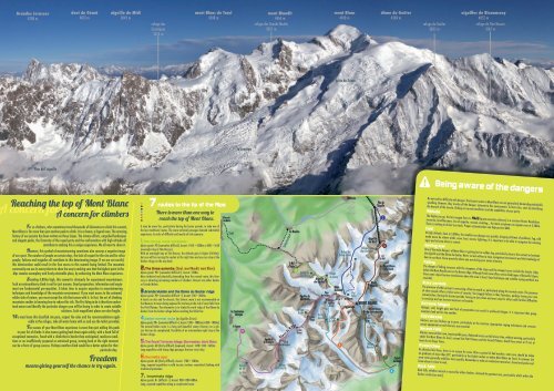
Grandes Jorasses<br />
4208 m<br />
Plan de l’aiguille<br />
dent du Géant<br />
4013 m<br />
aiguille du Midi<br />
3842 m<br />
Reaching the top of Mont Blanc<br />
<strong>concern</strong> <strong>for</strong> A <strong>climbers</strong> <strong>concern</strong> <strong>for</strong> <strong>climbers</strong><br />
For us <strong>climbers</strong>, who sometimes travel thousands of kilometres to climb this summit,<br />
Mont Blanc is far more than just another peak to climb. It is a dream, a legend even. The amazing<br />
history of our passion has been written on these slopes. The intense ef<strong>for</strong>ts, unspoiled landscapes<br />
and elegant peaks, the fraternity of the roped party and the confrontation with high altitude all<br />
contribute to making this a unique experience. We all want to share it.<br />
However, this symbol of mountaineering sometimes also conveys a negative image<br />
of our sport. The number of people on certain days, the lack of respect <strong>for</strong> the site and <strong>for</strong> other<br />
people, failures and tragedies all contribute to this deteriorating image. If we are not careful,<br />
this deterioration could result in the free access to this summit being limited. The mountain<br />
community can use its many talents to show the way to making sure that the highest point in the<br />
Alps remains exemplary and freely attainable place, by enhancing the Mont Blanc experience.<br />
Standing 4,810m high, this summit is obviously <strong>for</strong> experienced mountaineers.<br />
Such an extraordinary climb is not <strong>for</strong> just anyone. Good preparation, in<strong>for</strong>mation and equipment<br />
are fundamental pre-requisites. It takes time to acquire expertise in mountaineering<br />
techniques and knowledge of the mountain environment. If you want access to the untamed,<br />
wilder side of nature, you must accept the risk that comes with it. In fact, the art of climbing<br />
mountains resides in knowing how to reduce this risk. The first thing to do is there<strong>for</strong>e understand<br />
nature and identify the particular dangers you will be facing in order to create suitable<br />
solutions. Such magnificent places are also fragile.<br />
We must leave this classified site pure, respect the rules and the recommendations applicable<br />
in the refuges, take all waste home with us and use the toilets provided.<br />
The success of your Mont Blanc experience is more than just adding this peak<br />
to your list of climbs: it also means getting back down again safely, with a head full of<br />
exceptional memories. Faced with a climb that is harder than anticipated, mediocre conditions<br />
or an insufficiently prepared or untrained group, turning back at the right moment<br />
can be a <strong>for</strong>m of group success. Perhaps another climb would be a better option <strong>for</strong> that<br />
particular day.<br />
Freedom<br />
means giving yourself the chance to try again.<br />
refuge des<br />
Cosmiques<br />
3613 m<br />
mont Blanc du Tacul<br />
4248 m<br />
7 routes to the tip of the Alps<br />
There is more than one way to<br />
reach the top of Mont Blanc.<br />
It may be more fun, particularly during the busier periods, to take one of<br />
the less traditional routes. The more technical passages demand substantial<br />
experience. In order of difficulty and mostly of risk exposure:<br />
1.The normal route via Goûter.<br />
Alpine grade: PD (somewhat difficult). Ascent: 1450 + 1000m or 800 + 1650<br />
(overnight stop at Tête Rousse)<br />
With an overnight stay at Tête Rousse, the altitude gain is higher (1650m),<br />
but you will be crossing the couloir at the right time and you can stop at the<br />
Goûter refuge on the way back.<br />
2.The three summits. (Tacul, mont Maudit, mont Blanc).<br />
Alpine grade: PD+ (somewhat difficult+). Ascent: 1200m<br />
More technical and physically demanding than the normal route, this itinerary<br />
is attracting increasing numbers of <strong>climbers</strong>. Descent via either Goûter<br />
or Grands Mulets.<br />
3.Grands Mulets and the Dôme du Goûter ridge<br />
Alpine grade: PD+ (somewhat difficult +). Ascent: 700 + 1800m.<br />
A classic on skis and <strong>for</strong> descent, this historic route is not recommended on<br />
foot because it means being exposed <strong>for</strong> too long to the risk of serac falls from<br />
the Petit Plateau. The alternative is to climb the north ridge of the Dôme du<br />
Goûter from the Goûter refuge be<strong>for</strong>e reaching the Vallot hut.<br />
4.Italian normal route (or Aiguilles Grises)<br />
Alpine grade: PD+ (somewhat difficult +). Ascent: 1300 + 1800m (or 800 + 1000m)<br />
The normal Italian route is a long and beautiful snowy itinerary on a glacier<br />
that can be complicated. Possibility of an intermediate night stop at the<br />
Goûter refuge.<br />
5.The Royal Traverse: Miage, Bionnassay, Mont Blanc<br />
Alpine grade: AD (fairly difficult) (exposed). Ascent: 1450+1100 +1650m<br />
Long expedition with sharp ridge passages that are very tricky.<br />
6.Tournette spur<br />
Alpine grade: AD (fairly difficult). Ascent: 1700 + 1400m.<br />
Long, exposed expedition in wild terrain; involves committed climbing with<br />
traditional protection.<br />
7. Innominata ridge<br />
Alpine grade: D+ (difficult +). Ascent: 900+1500+800m.<br />
Long, exposed expedition along a complicated route.<br />
St-Gervaisles-Bains<br />
TMB<br />
les Contamines-<br />
Montjoie<br />
le Cugnon<br />
la Jonction<br />
5<br />
Refuge<br />
de Tré -<br />
la -Tête<br />
mont Maudit<br />
4465 m<br />
refuge des Grands Mulets<br />
3051 m<br />
Aiguille de<br />
la Bérangère<br />
Col de<br />
la Bérangère<br />
Refuge<br />
des Conscrits<br />
Téléphérique<br />
les Houches<br />
le Nid<br />
d'Aigle<br />
1<br />
D ô m e s d e M ia g e<br />
Refuge de<br />
Tête Rousse<br />
Aiguilles de<br />
Bionnassay<br />
Refuge<br />
Durier<br />
Col des<br />
Dômes<br />
Col de<br />
Miage<br />
Aiguille<br />
du Gôuter<br />
˚<br />
Piton<br />
des Italiens<br />
Refuge<br />
du Goûter<br />
Col des<br />
Aiguilles<br />
Grises<br />
Refuge<br />
Gonella Refuge<br />
Q. Sella<br />
mont Blanc<br />
4810 m<br />
Arête du Dôme<br />
Chamonix<br />
Refuge des<br />
Grands Mulets<br />
Dôme<br />
du Goûter ˚<br />
Abri<br />
Col du Vallot<br />
Dôme les Bosses<br />
6<br />
la Tournette<br />
Téléphérique<br />
Aiguille<br />
du Midi<br />
Refuge<br />
des Cosmiques<br />
Mont<br />
Maudit<br />
MONT BLANC<br />
Plan de<br />
l'Aiguille<br />
Mont Blanc<br />
de Courmayeur<br />
Col<br />
Eccles<br />
Bivouac<br />
Eccles<br />
Refuge<br />
Monzino<br />
dôme du Goûter<br />
4304 m<br />
3<br />
2<br />
Col<br />
du Midi<br />
Mont Blanc<br />
du Tacul<br />
7<br />
4<br />
Chalets<br />
du Miage<br />
refuge du Goûter<br />
3835 m<br />
!<br />
aiguilles de Bionnassay<br />
4052 m<br />
refuge de Tête Rousse<br />
3167 m<br />
Do not confuse difficulty with danger. The busiest routes to Mont Blanc are not particularly demanding technically<br />
speaking. However, they involve all the dangers inherent to this environment. To limit risks, start by identifying<br />
the hazards of the terrain, finding out current conditions and the capabilities of your party.<br />
Altitude<br />
The higher you go, the less oxygen there is. AMS (acute mountain sickness) is a constant threat. Headaches,<br />
insomnia, breathlessness, loss of appetite, nausea, vomiting… the main symptoms can appear even at 3,500m.<br />
There is nothing to do but turn back. Proper acclimatisation can help prevent AMS.<br />
Cold<br />
At high altitude, close to 5,000m, the weather can change very quickly, bringing all kinds of problems: fog, cold<br />
made worse by violent winds, snow, frost, storms, lightning. It is important to be able to recognise the warning<br />
signs and to know when to retreat.<br />
Getting lost<br />
One of the main dangers of Mont Blanc is getting lost in sudden fog, particularly close to the summit or between<br />
the Aiguille and the Dôme du Goûter. Never set out without a map, navigation instruments and the knowledge of<br />
how to use them. Know precisely where you are during your entire itinerary.<br />
Falling<br />
The danger of falling increases with the steepness of the slope and the steepest areas include the Goûter ridge,<br />
below the Mont Maudit pass or the Bosses ridge. Although fresh snow offers serene landscapes of beautiful slopes,<br />
these same slopes become treacherous when the snow is hard. Good technique and suitable roping methods are<br />
essential.<br />
Busy periods<br />
The presence of other groups is reassuring, often too much so, particularly along the normal routes. The presence<br />
of other people offers a false sense of security. You happily follow in their footsteps, perhaps losing your own<br />
concentration. During the busiest periods, having to slow down and even stop <strong>for</strong> others adds further difficulties<br />
to crossings and can increase exposure to hazards.<br />
Extreme fatigue<br />
Altitude, cold, height gain and lack of preparation can result in profound fatigue. It is important that group<br />
members look out <strong>for</strong> one another.<br />
Crevasses<br />
Glaciers are very broken up in parts, particularly at the Jonction. Appropriate roping techniques and crevasse<br />
rescue equipment on each harness are essential.<br />
Seracs Falls<br />
Glaciers move at their own, imperceptible pace. Balanced seracs can fall at any time, without warning, particularly<br />
under the Mont Blanc du Tacul, around the Petit Plateau and the Grand Plateau. Avoid these areas or if not, at<br />
least do not linger there.<br />
Avalanches<br />
At altitudes like these, there is no season <strong>for</strong> snow. After a period of bad weather, extra care should be taken<br />
on gradients of more than 30°, particularly in the Goûter couloir or below Mont Blanc du Tacul. In summer, the<br />
snow cover generally stabilises more quickly. Remember to take an avalanche transceiver, shovel and probe and<br />
know when it is best to wait.<br />
Rock falls<br />
Being aware of the dangers<br />
Rock falls, whether natural or caused by other <strong>climbers</strong>, demand the greatest care, particularly whilst within the<br />
Goûter couloir (see over).
La Coordination Montagne<br />
Maison de la Montagne<br />
3, rue Raoul Blanchard, 38000 Grenoble.<br />
+33(0)4 76 51 75 41<br />
www.coordination-montagne.fr<br />
Layout and illustrations: Bérengère Collas<br />
Map: JM Boudou<br />
Photos: Mario Colonel<br />
Texts: Olivier Obin, Niels Martin and Philippe Descamps<br />
Supported bye:<br />
The national coordination committee <strong>for</strong> the development of mountain and climbing<br />
activities (Coordination Montagne), created in January 2012, comprises: FFCAM (French<br />
federation of mountain climbing clubs), FFME (French mountain and climbing federation),<br />
FFRP (French hiking federation), GHM, (high mountain group), SNGM (union<br />
of mountain guides), SNGRGE (refuge warden union), SNAPEC (union of climbing and<br />
canyoning professionals), SNAM (union of mountain monitors), UCPA (union of outdoor<br />
sports centres), GTA (Grande Traversée des Alpes), MW (Mountain Wilderness), ANCEF<br />
(association of mountain and cross country ski centres), CIPRA, the <strong>Petzl</strong> Foundation,<br />
En Passant par la Montagne, Sportsnature.org research network, the Mountain Biker’s<br />
Foundation.<br />
This document was devised and produced by the national<br />
coordination committee <strong>for</strong> the development of mountain<br />
and climbing activities.<br />
1 2<br />
3<br />
Preparation Equipment In<strong>for</strong>mation<br />
To attempt Mont Blanc with a good<br />
chance of success, experience of high<br />
mountains, regular training and<br />
preparation are essential. Good<br />
guides are also a decisive factor.<br />
In terms of physical preparation <strong>for</strong> this summit,<br />
you should not only be in good physical<br />
condition, but also have tested your<br />
level of fitness at altitude. A first experience<br />
of an easier “4,000” and at least one<br />
night spent recently at more than 3,000m will<br />
give you a better idea of your real condition.<br />
The techniques you will need<br />
to know include knowing how to<br />
use crampons, how to climb in<br />
varied terrain and cross ridges,<br />
and being able to adjust your<br />
rope (long on the glacier, short<br />
along the ridges, etc.).<br />
++<br />
Tête Rousse glacier<br />
From 1990 to 2011, 74 people died and<br />
180 were injured along this route, between the<br />
Tête Rousse and Goûter refuges.<br />
Studies are underway to attempt to limit the<br />
high risk presented by rock falls.<br />
In its current state, mountaineers must be<br />
aware of the dangers of this itinerary and be<br />
prepared to face them.<br />
Approximately half of<br />
all accidents occur along<br />
the 100m couloir crossing,<br />
and one third along<br />
the ridge.<br />
Psychologically,<br />
you must be prepared <strong>for</strong> bad nights and long<br />
days in a fabulous, but hostile, different and<br />
changing environment.<br />
Preparing your expedition means studying<br />
the terrain by reading maps, topoguides and<br />
expedition reports.<br />
A club can help you to find a partner <strong>for</strong><br />
your expedition, an initial experience<br />
and training courses.<br />
A professional guide can advise, prepare<br />
and supervise you, taking on<br />
responsibility <strong>for</strong> the expedition.<br />
Finding a club:<br />
www.thebmc.co.uk; www.alpine-club.org.uk; www.americanalpineclub.org<br />
Finding a professional guide:<br />
In France: www.sngm.fr<br />
In Aosta Valley: www.guidealtamontagna.com<br />
In Switzerland: www.4000plus-vs.ch<br />
The hazards of the<br />
normal route<br />
The Goûter couloir is where most of the<br />
more serious accidents occur.<br />
Payot ridge<br />
Old refuge New refuge<br />
Ridge<br />
Couloir<br />
crossing<br />
Most are caused by a climber falling, often<br />
directly or indirectly related to a<br />
rock fall. In relation to traffic, there are<br />
at least as many accidents on the way down,<br />
particularly along the ridge. We also know that<br />
two thirds of all casualties were not roped, and<br />
that fewer accidents involve people accompanied<br />
by a professional guide. A study carried<br />
out in summer 2011 <strong>concern</strong>ing the couloir<br />
alone estimated that one thousand of the<br />
estimated 17,000 crossings of the couloir were<br />
affected by rock fall. While rock falls can occur<br />
at any time of day or season, certain factors<br />
can aggravate or reduce the risk.<br />
.<br />
.<br />
.<br />
.<br />
Part of the expedition means finding the right equipment,<br />
remembering the essentials without weighing yourself<br />
down with the superfluous.<br />
As well as clothing suitable <strong>for</strong> high altitude conditions<br />
and extremely cold temperatures (including<br />
spare gloves), the equipment is that<br />
of a mountaineer on a glacier<br />
(ice axe, crampons, harness, rope, etc.).<br />
Remember that you must<br />
be prepared:<br />
To protect yourself: helmet,<br />
glasses, sun-cream (avalanche transceiver,<br />
shovel and probe, depending<br />
on your route and local conditions).<br />
To find your way:<br />
map, topo, compass, altimeter,<br />
whistle, headlamp (GPS).<br />
To eat and drink: food<br />
rations, hot drinks.<br />
For rescue operations:<br />
crevasse rescue kit (5 karabiners,<br />
3 ice screws, self-locking pulley, 2<br />
rope clamps, sling, cordelette),<br />
telephone or radio, appropriate<br />
first aid kit.<br />
Risk aggravating<br />
factors:<br />
.Temperatures above zero.<br />
.Dry air: nice, sunny weather.<br />
The most critical time is<br />
between<br />
11am and 1.30pm.<br />
.How to cross the<br />
Goûter couloir?<br />
As with all the other parts of the routes,<br />
assessing the current conditions remains<br />
an essential factor when choosing the techniques<br />
to be implemented. The main<br />
principles to be remembered include:<br />
.Always wear a helmet and stay<br />
roped together.<br />
.Prepare your equipment a good distance<br />
be<strong>for</strong>e crossing the couloir and not close to<br />
its edges, which are highly exposed.<br />
.Check current conditions be<strong>for</strong>e deciding<br />
whether or not to cross the couloir.<br />
.If possible, keep a lookout from a sheltered<br />
position <strong>for</strong> the roped party be<strong>for</strong>e you.<br />
.Do not waste time in the couloir, but do not<br />
hurry unnecessarily either.<br />
For more in<strong>for</strong>mation:<br />
www. petzl-foundation.org<br />
Risk reducing<br />
factors:<br />
What about<br />
me... can I<br />
come too?<br />
. Temperatures below zero.<br />
. Cloudy weather, with little sun. The presence<br />
of snow in the couloir has no influence on the<br />
regularity of rock falls. However, it does help<br />
to prevent other blocks being pulled down<br />
and rocks rebounding along the couloir.<br />
.If the snow means your crampons hold<br />
well, you may not need the cable.<br />
Otherwise, use the cable according to<br />
recommendations (attached with a suitable<br />
technique, using a “floating” karabiner<br />
between two members of the roped party).<br />
.Along the ridge, use the cables and their<br />
anchors <strong>for</strong> belaying – but beware, this is<br />
not a via ferrata.<br />
. Weather and mountain conditions:<br />
High mountain office: +33 (0)4 50 53 22 08; www.chamoniarde.com<br />
Meteo France weather <strong>for</strong>ecast: (France only) 08 99 71 02 74; www.meteofrance.com<br />
Aosta Valley weather <strong>for</strong>ecast: (+39) 0165 272 333; www.regione.vda.it<br />
Swiss mountain bulletin: (+41) 0900900 162 168; www.meteosuisse.admin.ch<br />
Chamonix mountain gendarmes: +33 (0)4 50 55 33 72<br />
. Refuges and huts:<br />
Tête Rousse: +33 (0)4 50 58 24 97; booking is compulsory: refugeteterousse.ffcam.fr<br />
Goûter: +33 (0)4 50 54 40 93; booking is compulsory: refugedugouter.ffcam.fr<br />
Tré la tête: +33 (0)4 50 47 01 68; www.trelatete.com<br />
Gonella: (+39) 0165 885 101; www.rifugiogonella.com<br />
Monzino: (+39) 0165 809 553<br />
Cosmiques: +33 (0)4 50 54 40 16<br />
Grands Mulets: +33 (0)4 50 53 57 10<br />
Conscrits: +33 (0)4 79 89 09 03<br />
Durier: +33 (0)6 89 53 25 10<br />
. Lifts:<br />
Opening hours: www.compagniedumontblanc.fr<br />
Aiguille du Midi cable car: +33 (0)4 50 53 22 75<br />
Bellevue cable car: +33 (0)4 50 54 70 93<br />
Mont-Blanc tramway: +33 (0)4 50 47 51 83<br />
. Tourist in<strong>for</strong>mation:<br />
Chamonix: +33 (0)4 50 53 00 24; www.chamonix.com<br />
Les Houches-Servoz: +33 (0)4 50 55 50 62; www.leshouches.com<br />
Saint-Gervais-les-Bains: +33 (0)4 50 47 76 08; www.saintgervais.com<br />
Val Montjoie: +33 (0)4 50 47 01 58; www.lescontamines.com<br />
Vallée d’Aoste: (+39) 0165 842 060; www.lovevda.it<br />
Valais: (+41) 27 783 2717 ; www.st-bernard.ch<br />
!!<br />
Conditions change quickly in the mountains and the<br />
weather changes even faster. To make the right decisions,<br />
you have to have the right in<strong>for</strong>mation and<br />
know how to interpret it with a critical mind.<br />
If an accident occurs<br />
If you see an accident, you must take the usual<br />
emergency precautions:<br />
PROTECT<br />
Be<strong>for</strong>e doing anything else, prevent further accidents by protecting others.<br />
Never move a casualty unless he/she is in direct, imminent danger, in which<br />
case, be careful to keep the torso/neck/ head aligned and<br />
protect against the cold.<br />
ALERT<br />
Telephone network and radio coverage (150MHz)<br />
is generally good in the Mont Blanc area.<br />
If neither work, send a messenger (not alone<br />
if possible) to in<strong>for</strong>m the nearest refuge or<br />
find an alert area.<br />
A single emergency number:<br />
112<br />
FIRST AID<br />
While waiting <strong>for</strong> the rescue team to arrive, you may<br />
have to take action quickly to open the casualty’s airway, stop bleeding, give CPR<br />
if the heart is not beating, secure a conscious or unconscious casualty. These are<br />
reactions that must be learned. All mountaineers should have appropriate first aid<br />
training.<br />
Guide the emergency team by <strong>for</strong>ming a “Y” (yes) with raised arms or by signalling<br />
SOS with a torch or mobile phone screen at night. Depending on the terrain, try to<br />
clear a landing area.<br />
When the helicopter arrives, stay where you are and wait <strong>for</strong> further instructions.<br />
Useful phone numbers:<br />
Valdotains alpine rescue: +39 (0)800 319 319<br />
Switzerland (Rega): 1414 or from abroad +41 333 333 333<br />
Dial<br />
112