Cycle map: Chester to Connah's Quay - Chester Cycling Campaign
Cycle map: Chester to Connah's Quay - Chester Cycling Campaign
Cycle map: Chester to Connah's Quay - Chester Cycling Campaign

Create successful ePaper yourself
Turn your PDF publications into a flip-book with our unique Google optimized e-Paper software.
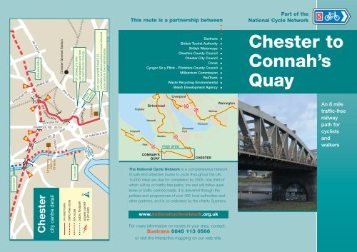
COU<br />
Canal path<br />
DICKSONS DR<br />
HOOLE RD<br />
BROOK LA<br />
RAILWAY PATH<br />
ERMINE RD<br />
NORTHGATE AVE<br />
VICTORIA RD<br />
LIVERPOOL RD<br />
PARKGATE RD<br />
CHEYNEY RD<br />
University<br />
College<br />
<strong>Chester</strong><br />
<strong>Chester</strong><br />
city centre detail<br />
<strong>Chester</strong> General Station<br />
A5116<br />
HOOLE WAY<br />
A540<br />
on-road route<br />
traffic-free route<br />
ST. OSWALD'S WAY<br />
use segregated cycle lane<br />
<strong>to</strong> reach <strong>to</strong>ucan crossing.<br />
Link route<br />
A5268<br />
link route<br />
public footpath<br />
follow<br />
one-way<br />
system<br />
GEORGE ST<br />
N<br />
RD<br />
STH.VIEW<br />
access control<br />
(1.2m slot)<br />
Cathedral<br />
TOWER<br />
Link route via NORTHGATE ST -<br />
contraflow lane allows cyclists <strong>to</strong> travel outbound.<br />
<strong>Cycle</strong> racks at Town Hall/Cathedral.<br />
ST. MARTIN'S WAY<br />
This route is a partnership between<br />
•<br />
•<br />
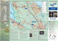
Hoylake<br />
Holywell<br />
Flint<br />
Sustrans<br />
British Tourist Authority<br />
British Waterways<br />
Cheshire County Council<br />
<strong>Chester</strong> City Council<br />
Corus<br />
Cyngor Sir y Fflint - Flintshire County Council<br />
Millennium Commission<br />
RailTrack<br />
Waste Recycling Environmental<br />
Welsh Development Agency<br />
Birkenhead<br />
Heswall<br />
5<br />
CONNAH'S<br />
QUAY<br />
Nes<strong>to</strong>n<br />
Liverpool<br />
56<br />
<strong>map</strong> area<br />
56<br />
Ellesmere<br />
Port<br />
62<br />
Runcorn<br />
CHESTER<br />
Widnes<br />
Warring<strong>to</strong>n<br />
The National <strong>Cycle</strong> Network is a comprehensive network<br />
of safe and attractive routes <strong>to</strong> cycle throughout the UK.<br />
10,000 miles are due for completion by 2005, one third of<br />
which will be on traffic-free paths, the rest will follow quiet<br />
lanes or traffic-calmed roads. It is delivered through the<br />
policies and programmes of over 450 local authorities and<br />
other partners, and is co-ordinated by the charity Sustrans.<br />
www.nationalcyclenetwork.org.uk<br />
For more information on routes in your area, contact:<br />
Sustrans 0845 113 0566<br />
or visit the interactive <strong>map</strong>ping on our web site.<br />
•<br />
•<br />
•<br />
•<br />
•<br />
•<br />
•<br />
•<br />
•<br />
•<br />
•<br />
•<br />
Part of the<br />
National <strong>Cycle</strong> Network<br />
<strong>Chester</strong> <strong>to</strong><br />
Connah’s<br />
<strong>Quay</strong><br />
An 8 mile<br />
traffic-free<br />
railway<br />
path for<br />
cyclists<br />
and<br />
walkers
To Flint<br />
5<br />
CONNAH'S<br />
QUAY<br />
Low Level Station<br />
Shot<strong>to</strong>n<br />
on-road route<br />
traffic-free route<br />
link route<br />
public footpath<br />
Hawarden<br />
Bridge<br />
Station<br />
High Level<br />
Station<br />
Queensferry<br />
scale<br />
0 1mile<br />
© Crown copyright. All rights reserved Sustrans.<br />
Licence No: GD03181G0001<br />
Deeside Industrial Park<br />
CORUS WORKS<br />
railway<br />
access control<br />
(1.2m slot)<br />
PARKWAY<br />
Garden City<br />
Sustrans - the sustainable transport charity - works on<br />
practical projects <strong>to</strong> encourage people <strong>to</strong> walk, cycle and<br />
use public transport in order <strong>to</strong> reduce mo<strong>to</strong>r traffic and its<br />
adverse effects. 5,000 miles of our flagship project, the<br />
National <strong>Cycle</strong> Network, were officially opened in June<br />
2000, we will increase this <strong>to</strong> 10,000 miles by 2005.<br />
As well as the National <strong>Cycle</strong> Network, Sustrans is working<br />
on Safe Routes <strong>to</strong> School, Home Zones and other practical<br />
responses <strong>to</strong> the transport and environmental challenges<br />
we face. Sustrans' work relies on the generous donations<br />
and monthly standing orders of nearly 40,000 Supporters,<br />
and the support of charitable trusts, companies, the<br />
National Lottery and local authority programmes.<br />
N<br />
A550<br />
A548<br />
A550<br />
RAF<br />
Sealand<br />
Camp<br />
GREEN LANE EAST<br />
Sealand<br />
SEAHILL RD<br />
Saughall<br />
HERMITAGE RD<br />
SEALAND RD A458<br />
<strong>Chester</strong> <strong>to</strong> Connah’s <strong>Quay</strong> Railway Path<br />
Phase one of this path runs from Fairfield Road <strong>to</strong><br />
Hawarden Bridge along the former Mickle Trafford freight<br />
line, and forms part of National <strong>Cycle</strong> Network Route 5.<br />
MAYFIELD RD<br />
Links from Abbots Mead along the Shropshire Union canal<br />
<strong>to</strong>wpath and from Brook Lane via Northgate Village, and<br />
Northgate Street provide connections <strong>to</strong> <strong>Chester</strong> City<br />
Centre. Flintshire County Council are continually improving<br />
links between Shot<strong>to</strong>n and the path.<br />
The intention is <strong>to</strong> extend the railway path <strong>to</strong>ward Mickle<br />
Trafford as part of the Network route <strong>to</strong> Delamere Forest.<br />
Wales<br />
England<br />
HIGHFIELD RD<br />
Blacon<br />
PARKGATE RD A540<br />
EGERTON RD<br />
SAUGHALL RD<br />
SAUGHALL RD<br />
CRANLEIGH CRES<br />
BLACON AVE<br />
DEVA LINK<br />
CHESTER<br />
see detail<br />
PARKGATE RD<br />
LIVERPOOL RD<br />
LIVERP OOL RD<br />
NORTHGATE AVE<br />
A5116<br />
Bache<br />
Station<br />
To <strong>Chester</strong> Zoo, Wirral Way,<br />
Nes<strong>to</strong>n, New Brigh<strong>to</strong>n and<br />
Liverpool via ferry<br />
5<br />
BROOK LANE<br />
HOOLE RD<br />
<strong>Chester</strong><br />
General Station<br />
Shropshire Union Canal <strong>to</strong>wpath<br />
is part of Regional Route 70<br />
"Cheshire <strong>Cycle</strong>way"<br />
A41<br />
A56<br />
FAIRFIELD RD<br />
The whole of the former railway is being treated as a narrow<br />
linear park and woodland. Please look after the trees and<br />
plants and help us <strong>to</strong> keep the path clean and tidy.<br />
useful numbers<br />
Cheshire County Council <strong>Cycling</strong> Officer 01244 603617<br />
Flintshire County Council <strong>Cycling</strong> Officer 01352 704633<br />
Sustrans Crewe office 01270 211030