
You also want an ePaper? Increase the reach of your titles
YUMPU automatically turns print PDFs into web optimized ePapers that Google loves.
6<br />
What we value – environment,<br />
heritage and character<br />
The draft Auckland Unitary Plan looks to safeguard <strong>the</strong> things<br />
we value in Auckland, through ei<strong>the</strong>r specific zones (such as<br />
coastal areas) or overlays on residential zones (such as historic<br />
heritage or local precinct rules).<br />
Water quality<br />
There are two significant changes from past plans. Firstly,<br />
intensive livestock farming operations (more than 18 stock<br />
units per hectare) will have to ensure that stock is kept out<br />
of streams and <strong>the</strong> coastal marine area. They will have five<br />
years to do this for permanent streams, and ano<strong>the</strong>r five years<br />
(10 years in total) to do this for intermittent streams. The<br />
plan recognises that <strong>the</strong>re are a number of ways this may be<br />
achieved so leaves it up to land managers (those using <strong>the</strong><br />
land) to decide <strong>the</strong> best method.<br />
Secondly, while <strong>the</strong> marine pollution regulations already<br />
provide some limits on where untreated sewage can be<br />
discharged from boats, <strong>the</strong>n concerns remain about <strong>the</strong><br />
potential effects on human health and cultural values. To<br />
manage <strong>the</strong>se issues, in addition to <strong>the</strong> marine pollution<br />
regulations, <strong>the</strong> draft plan proposes to control <strong>the</strong>se<br />
discharges within 2km of <strong>the</strong> shoreline.<br />
Natural character and landscapes<br />
The RMA requires councils to identify and protect areas with<br />
outstanding or high natural character and landscape coastal<br />
values. In <strong>the</strong> draft plan <strong>the</strong>re are controls on new buildings,<br />
earthworks and vegetation removal that apply to <strong>the</strong>se areas.<br />
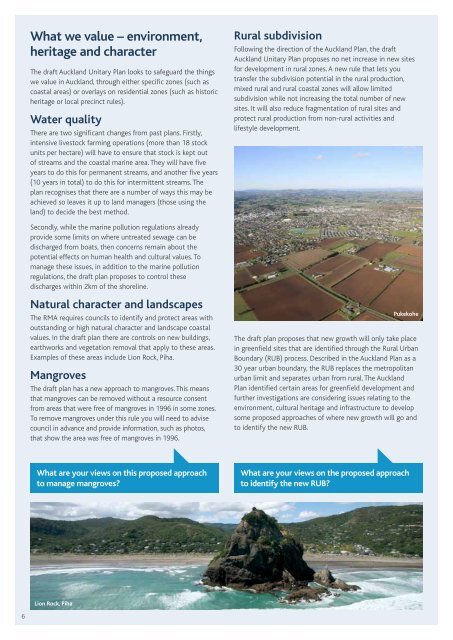
Examples of <strong>the</strong>se areas include Lion Rock, Piha.<br />
Mangroves<br />
The draft plan has a new approach to mangroves. This means<br />
that mangroves can be removed without a resource consent<br />
from areas that were free of mangroves in 1996 in some zones.<br />
To remove mangroves under this rule you will need to advise<br />
council in advance and provide information, such as photos,<br />
that show <strong>the</strong> area was free of mangroves in 1996.<br />
What are your views on this proposed approach<br />
to manage mangroves?<br />
Lion Rock, Piha<br />
Rural subdivision<br />
Following <strong>the</strong> direction of <strong>the</strong> Auckland Plan, <strong>the</strong> draft<br />
Auckland Unitary Plan proposes no net increase in new sites<br />
for development in rural zones. A new rule that lets you<br />
transfer <strong>the</strong> subdivision potential in <strong>the</strong> rural production,<br />
mixed rural and rural coastal zones will allow limited<br />
subdivision while not increasing <strong>the</strong> total number of new<br />
sites. It will also reduce fragmentation of rural sites and<br />
protect rural production from non-rural activities and<br />
lifestyle development.<br />
Pukekohe<br />
The draft plan proposes that new growth will only take place<br />
in greenfield sites that are identified through <strong>the</strong> Rural Urban<br />
Boundary (RUB) process. Described in <strong>the</strong> Auckland Plan as a<br />
30 year urban boundary, <strong>the</strong> RUB replaces <strong>the</strong> metropolitan<br />
urban limit and separates urban from rural. The Auckland<br />
Plan identified certain areas for greenfield development and<br />
fur<strong>the</strong>r investigations are considering issues relating to <strong>the</strong><br />
environment, cultural heritage and infrastructure to develop<br />
some proposed approaches of where new growth will go and<br />
to identify <strong>the</strong> new RUB.<br />
What are your views on <strong>the</strong> proposed approach<br />
to identify <strong>the</strong> new RUB?