
Create successful ePaper yourself
Turn your PDF publications into a flip-book with our unique Google optimized e-Paper software.
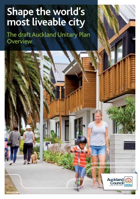
<strong>Shape</strong> <strong>the</strong> <strong>world’s</strong><br />
<strong>most</strong> <strong>liveable</strong> <strong>city</strong><br />
The draft Auckland Unitary Plan<br />
Overview<br />
Hobsonville Point
2<br />
Message from Deputy Mayor, Penny Hulse<br />
Kia ora tatou,<br />
This is an exciting time<br />
to be an Aucklander.<br />
There’s a new sense of<br />
optimism, confidence<br />
and pride across our<br />
communities, and a<br />
real willingness to work<br />
toge<strong>the</strong>r to resolve<br />
<strong>the</strong> challenges we face<br />
and seize <strong>the</strong> many<br />
opportunities.<br />
Above all, it is wonderful to see how committed so many<br />
people, groups and organisations are to achieving <strong>the</strong><br />
Auckland-wide vision of becoming <strong>the</strong> <strong>world’s</strong> <strong>most</strong><br />
<strong>liveable</strong> <strong>city</strong>.<br />
It’s time for all of us to make that vision a reality. A major<br />
step is <strong>the</strong> Auckland Unitary Plan, <strong>the</strong> planning rulebook<br />
that will shape <strong>the</strong> way Auckland grows for years and<br />
generations to come. It is about creating more vibrant<br />
local communities. It will set out what can be built and<br />
where, shape where we live, where we work and how we<br />
look after <strong>the</strong> things we <strong>most</strong> value in both our urban and<br />
rural areas.<br />
The Auckland Unitary Plan is extremely important; it affects<br />
every Aucklander and we have to get it right. We want to<br />
hear what Aucklanders think about <strong>the</strong> draft plan before it<br />
reaches <strong>the</strong> formal stages of development. This is <strong>the</strong> first time<br />
everyone in Auckland has <strong>the</strong> chance to have a say before <strong>the</strong><br />
formal process starts.<br />
Please take <strong>the</strong> time to look at <strong>the</strong> draft Auckland Unitary<br />
Plan, to see what it says about your home, your community<br />
and Auckland as a whole – tell us what you think.<br />
Have your say and help us get it right for Auckland’s future.<br />
Visit www.shapeauckland.co.nz<br />
“Tāwhiti rawa tōu haerenga ake te kore haere tonu; nui rawa ōu mahi te kore mahi nui tonu.”<br />
We have come too far not to go fur<strong>the</strong>r; we have done too much not to do more.<br />
The draft Auckland Unitary Plan<br />
The draft Auckland Unitary Plan will eventually replace 14<br />
of Auckland’s existing district and regional plans, many of<br />
which are already more than 10 years old. It will be <strong>the</strong> key<br />
tool to implement <strong>the</strong> Auckland Plan, which sets <strong>the</strong> strategic<br />
direction for Auckland’s growth over <strong>the</strong> next 30 years. It is<br />
developed under <strong>the</strong> Resource Management Act 1991 (RMA)<br />
– making it <strong>the</strong> main regulatory tool for delivering <strong>the</strong><br />
Auckland Plan.<br />
What’s in it?<br />
• The Regional Policy Statement – this is <strong>the</strong> part of <strong>the</strong> plan<br />
that sets <strong>the</strong> framework for managing Auckland’s resources<br />
such as <strong>the</strong> coast, air, water and land.<br />
• Regional and district objectives and policies – <strong>the</strong>se are <strong>the</strong><br />
way we describe what we want to achieve for <strong>the</strong> region.<br />
• Rules – <strong>the</strong>se are <strong>the</strong> nuts and bolts of how we reach <strong>the</strong>se<br />
objectives.<br />
• Definitions – a list of all <strong>the</strong> key words and <strong>the</strong>ir meanings.<br />
• Designations – <strong>the</strong>se cover public works, such as roads, and<br />
infrastructure, such as water treatment plants.<br />
• Maps – showing your property, zones, schedules, precincts<br />
and overlays.<br />
Sir James Hēnare<br />
Mission Bay<br />
A large print version of this document will be available at www.shapeauckland.co.nz from mid-March 2013.
Accessing <strong>the</strong> e-plan<br />
Delivery of <strong>the</strong> Auckland Unitary Plan as an e-plan makes Auckland’s planning rulebook more accessible and much easier to use<br />
than previous plans. The e-plan can be accessed on <strong>the</strong> Auckland Council website at www.aucklandcouncil.govt.nz/unitaryplan<br />
The planning enquiry page will help you to find <strong>the</strong> information that you need. It will reduce <strong>the</strong> amount of information you need<br />
to download. If you have no internet connection or find it is very slow to download <strong>the</strong> information from <strong>the</strong> website, visit your<br />
library or contact us on 09 301 0101 for o<strong>the</strong>r options for accessing <strong>the</strong> e-plan from 15 March to 31 May 2013.<br />
The e-plan is a first for Auckland Council and has not been done on this scale before anywhere else in New Zealand.<br />
http://unitaryplan.aucklandcouncil.govt.nz/<br />
http://acmaps.aucklandcouncil.govt.nz/unitaryplan<br />
Planning<br />
enquiry page<br />
GIS Viewer<br />
Have your say: www.shapeauckland.co.nz<br />
3
4<br />
Key <strong>the</strong>mes<br />
We now have one council for <strong>the</strong> whole of Auckland, making it possible to have one clear and consistent set of planning rules.<br />
At <strong>the</strong> same time, it’s essential that we maintain what makes our local areas special.<br />
The draft Auckland Unitary Plan sets out general rules, but uses a new concept of overlays. These include precincts and<br />
sub-precincts to reflect and safeguard local flavour, as well as overlays for o<strong>the</strong>r factors such as heritage protection,<br />
stormwater and volcanic viewshafts.<br />
Where we live –<br />
housing affordability,<br />
choice and urban design<br />
As Auckland continues to grow, we will need a much greater<br />
range and choice of homes to meet <strong>the</strong> needs of different<br />
households and to help improve housing affordability. We<br />
want people to be able to stay in <strong>the</strong>ir communities as <strong>the</strong>ir<br />
housing needs change through <strong>the</strong> different stages of life.<br />
The draft Auckland Unitary Plan sets out proposals for what<br />
people will be able to do with <strong>the</strong>ir properties and <strong>the</strong>ir land.<br />
It aims to enable people to do more, increasing housing<br />
opportunities to better match changing demands, with lower<br />
compliance costs and rules that are easier to understand. The<br />
draft plan proposes to rationalise <strong>the</strong> existing 99 residential<br />
zones across Auckland into five: Single House, Mixed<br />
Housing, Terraced Housing and Apartment Building, Large Lot<br />
Residential and Rural and Coastal Settlement.<br />
Following are <strong>the</strong> key features of each zone:<br />
• <strong>the</strong> Single House zone will allow a single house on a<br />
single lot<br />
• <strong>the</strong> Mixed Housing zone will encourage a mix of detached,<br />
semi-detached and attached dwellings, units, town houses,<br />
terraced houses and small scale apartment buildings<br />
• <strong>the</strong> Terraced Housing and Apartment Building zone<br />
encourages <strong>the</strong> development of apartments ranging from<br />
four to six storeys in height, as well as terraced housing<br />
• <strong>the</strong> Large Lot Residential zone will require <strong>the</strong> creation of<br />
large lots on land that is subject to physical or landscape<br />
constraints and is generally unserviced<br />
• <strong>the</strong> Rural and Coastal Settlement zone applies to small rural<br />
and coastal villages and provides for single dwellings on a<br />
lot but a larger minimum lot size control.<br />
The draft Auckland Unitary Plan is not simply about enabling<br />
Auckland to have more of <strong>the</strong> homes it needs – it also aims<br />
to ensure <strong>the</strong> better quality design of homes that Aucklanders<br />
want. It will be complemented by <strong>the</strong> Auckland Design Manual<br />
(currently being prepared), which will demonstrate good design<br />
and how it can help make Auckland a better place to live.<br />
What is your view on <strong>the</strong> new residential zones?<br />
Do you think this will help provide <strong>the</strong> right<br />
housing choice in your community?<br />
Single House<br />
Mixed Housing<br />
Terraced<br />
Housing and<br />
Apartment<br />
Building
Where we work – local jobs,<br />
business friendly<br />
The Auckland Plan has outlined a clear hierarchy of centres, with<br />
different roles and scales of development. The <strong>city</strong> centre is at <strong>the</strong><br />
top, with <strong>the</strong> biggest scale and intensity of development<br />
and no height restriction, in some areas. Metropolitan Centres like<br />
Takapuna and Manukau are a step down from <strong>the</strong> <strong>city</strong> centre, and<br />
<strong>the</strong> hierarchy continues all <strong>the</strong> way down to <strong>the</strong> corner dairy.<br />
Our centres are where public and private sector investment<br />
tends to be focused – for example public transport, libraries,<br />
leisure facilities and public spaces. This is where <strong>the</strong> draft plan<br />
proposes higher buildings, so that more businesses and residents<br />
can be closer to those facilities and benefit from that investment.<br />
More people living within or closer to town centres will also help<br />
to ensure more customers for local businesses and greater use<br />
of facilities and transport services, making <strong>the</strong>m more viable.<br />
The draft plan encourages commercial activities (retail and<br />
offices) away from industrial zones, to protect industrial land<br />
for <strong>the</strong>se uses.<br />
Urban design assessments for all new buildings in our centres,<br />
Business Park, Mixed Use and General Business zones will help<br />
to improve <strong>the</strong> quality of buildings and how <strong>the</strong>y relate to <strong>the</strong>ir<br />
surrounding area. These higher-density areas need good design. In<br />
industrial zones <strong>the</strong>re are limited urban design requirements and<br />
new buildings would not require resource consent.<br />
Do you think <strong>the</strong> proposed plan will help make<br />
our business areas work better and enable<br />
opportunities for local jobs?<br />
Fort Street shared space Local business<br />
Matakana Markets<br />
Proposed maximum height of centres<br />
Metropolitan Centres<br />
Albany, Botany, Henderson,<br />
Manukau, New Lynn, Papakura<br />
Newmarket, Sylvia Park, Takapuna,<br />
Westgate/Massey<br />
Town Centres<br />
Avondale, Glen Innes, Milford,<br />
Newton/Upper Symonds Street,<br />
Northcote, Manurewa, Onehunga,<br />
Ormiston, Pakuranga, Panmure,<br />
Royal Oak, Silverdale, Three Kings<br />
Browns Bay, Glen Eden, Glenfield,<br />
Highbury, Highland Park, Orewa,<br />
Ōtāhuhu, Papatoetoe<br />
Devonport, Ellerslie, Hunters Corner,<br />
Mangere, Mt Albert, Ōtara,<br />
Parnell, Ponsonby, Pt Chevalier,<br />
Pukekohe, Remuera, Stoddard Road,<br />
Sunnynook, Takanini, Te Atatu,<br />
Warkworth, Whangaparaoa<br />
Maximum 72.5m<br />
(18 storeys)<br />
Subject to special<br />
rules such as volcanic<br />
cone sightline<br />
Maximum 32.5m<br />
(8 storeys)<br />
Maximum 24.5m<br />
(6 storeys)<br />
Maximum 16.5m<br />
(4 storeys)<br />
St Lukes, Howick Specific overlay<br />
provisions dictate<br />
height<br />
Local Centres<br />
All local centres Maximum<br />
12.5-16.5m<br />
(3 or 4 storeys)<br />
Have your say: www.shapeauckland.co.nz<br />
5
6<br />
What we value – environment,<br />
heritage and character<br />
The draft Auckland Unitary Plan looks to safeguard <strong>the</strong> things<br />
we value in Auckland, through ei<strong>the</strong>r specific zones (such as<br />
coastal areas) or overlays on residential zones (such as historic<br />
heritage or local precinct rules).<br />
Water quality<br />
There are two significant changes from past plans. Firstly,<br />
intensive livestock farming operations (more than 18 stock<br />
units per hectare) will have to ensure that stock is kept out<br />
of streams and <strong>the</strong> coastal marine area. They will have five<br />
years to do this for permanent streams, and ano<strong>the</strong>r five years<br />
(10 years in total) to do this for intermittent streams. The<br />
plan recognises that <strong>the</strong>re are a number of ways this may be<br />
achieved so leaves it up to land managers (those using <strong>the</strong><br />
land) to decide <strong>the</strong> best method.<br />
Secondly, while <strong>the</strong> marine pollution regulations already<br />
provide some limits on where untreated sewage can be<br />
discharged from boats, <strong>the</strong>n concerns remain about <strong>the</strong><br />
potential effects on human health and cultural values. To<br />
manage <strong>the</strong>se issues, in addition to <strong>the</strong> marine pollution<br />
regulations, <strong>the</strong> draft plan proposes to control <strong>the</strong>se<br />
discharges within 2km of <strong>the</strong> shoreline.<br />
Natural character and landscapes<br />
The RMA requires councils to identify and protect areas with<br />
outstanding or high natural character and landscape coastal<br />
values. In <strong>the</strong> draft plan <strong>the</strong>re are controls on new buildings,<br />
earthworks and vegetation removal that apply to <strong>the</strong>se areas.<br />
Examples of <strong>the</strong>se areas include Lion Rock, Piha.<br />
Mangroves<br />
The draft plan has a new approach to mangroves. This means<br />
that mangroves can be removed without a resource consent<br />
from areas that were free of mangroves in 1996 in some zones.<br />
To remove mangroves under this rule you will need to advise<br />
council in advance and provide information, such as photos,<br />
that show <strong>the</strong> area was free of mangroves in 1996.<br />
What are your views on this proposed approach<br />
to manage mangroves?<br />
Lion Rock, Piha<br />
Rural subdivision<br />
Following <strong>the</strong> direction of <strong>the</strong> Auckland Plan, <strong>the</strong> draft<br />
Auckland Unitary Plan proposes no net increase in new sites<br />
for development in rural zones. A new rule that lets you<br />
transfer <strong>the</strong> subdivision potential in <strong>the</strong> rural production,<br />
mixed rural and rural coastal zones will allow limited<br />
subdivision while not increasing <strong>the</strong> total number of new<br />
sites. It will also reduce fragmentation of rural sites and<br />
protect rural production from non-rural activities and<br />
lifestyle development.<br />
Pukekohe<br />
The draft plan proposes that new growth will only take place<br />
in greenfield sites that are identified through <strong>the</strong> Rural Urban<br />
Boundary (RUB) process. Described in <strong>the</strong> Auckland Plan as a<br />
30 year urban boundary, <strong>the</strong> RUB replaces <strong>the</strong> metropolitan<br />
urban limit and separates urban from rural. The Auckland<br />
Plan identified certain areas for greenfield development and<br />
fur<strong>the</strong>r investigations are considering issues relating to <strong>the</strong><br />
environment, cultural heritage and infrastructure to develop<br />
some proposed approaches of where new growth will go and<br />
to identify <strong>the</strong> new RUB.<br />
What are your views on <strong>the</strong> proposed approach<br />
to identify <strong>the</strong> new RUB?
Open Space<br />
There are currently 31 Open Space zones in <strong>the</strong> existing District Plans. The draft Auckland Unitary Plan proposes replacing <strong>the</strong>se<br />
with four: Conservation; Informal Recreation; Sport and Active Recreation; and Civic and Community Spaces. The draft plan<br />
proposes one zone to replace <strong>the</strong> myriad of zones and different approaches for Auckland’s major sport and recreation facilities.<br />
Different precincts will be used to take account of <strong>the</strong> different requirements of <strong>the</strong>se facilities, which range from sports stadia<br />
such as Eden Park, through to <strong>the</strong> Zoo and MOTAT.<br />
Historic character and historic heritage<br />
Many Aucklanders are passionate about protecting our<br />
heritage and this is an important issue for <strong>the</strong> draft plan to<br />
address. In <strong>the</strong> plan, heritage will be recognised and managed<br />
in different ways, based on <strong>the</strong> significance of <strong>the</strong> place and<br />
<strong>the</strong> protection required.<br />
Our <strong>most</strong> significant heritage places, those that meet <strong>the</strong><br />
significance criteria set out in <strong>the</strong> draft unitary plan, are<br />
included in a heritage schedule. A unified schedule of historic<br />
heritage places has been created, with overlapping places and<br />
separate schedules of buildings, archaeological and maritime<br />
Auckland Botanic Gardens Eden Park<br />
Alberton House<br />
Mana Whenua<br />
sites, and o<strong>the</strong>r categories of heritage found in existing plans<br />
combined. The draft unitary plan proposes a new approach<br />
to evaluation, where all of <strong>the</strong> values that contribute to <strong>the</strong><br />
significance of a place are considered toge<strong>the</strong>r, ra<strong>the</strong>r than<br />
independently. Map overlays defining <strong>the</strong> extent of scheduled<br />
heritage places have been created, providing improved clarity<br />
for land owners.<br />
O<strong>the</strong>r areas of early business and residential development,<br />
including our distinctive villa suburbs, are collectively<br />
managed as historic character areas. These are subject to a<br />
different set of planning controls designed primarily to retain<br />
<strong>the</strong> traditional character of historic streetscapes. Historic<br />
character areas are shown as an overlay on <strong>the</strong> planning maps.<br />
Ano<strong>the</strong>r management tool proposed in <strong>the</strong> draft unitary plan<br />
is a demolition control overlay that is applied to parts of<br />
Auckland with a concentration of pre-1944 development that<br />
are not currently historic character areas. This overlay is an<br />
interim control that will manage demolition while heritage<br />
surveys are undertaken. Any proposed demolition within this<br />
overlay will trigger <strong>the</strong> requirement for resource consent.<br />
Do you think this is <strong>the</strong> right approach to<br />
look after our historic character and heritage?<br />
The draft Auckland Unitary Plan establishes a framework for how council will work toge<strong>the</strong>r<br />
with Mana Whenua to harness <strong>the</strong>ir valuable knowledge in managing Auckland’s natural and<br />
physical resources. This includes creating opportunities for Mana Whenua to help inform<br />
decisions and make decisions about resources which are important to <strong>the</strong>m, such as, how<br />
we identify and protect significant places and cultural landscapes. Marae and papakainga<br />
(a settlement or village which has whakapapa connections to that land) are enabled, to support<br />
<strong>the</strong> identity of Mana Whenua, streng<strong>the</strong>n communities and help achieve economic aspirations.<br />
Have your say: www.shapeauckland.co.nz<br />
7
Resource Management Act 1991 (RMA)<br />
The draft Auckland Unitary Plan is developed under <strong>the</strong> RMA, which is<br />
<strong>the</strong> main legislation protecting our environment. The RMA is designed to<br />
ensure activities like building houses, clearing bush, moving earth, taking<br />
water from a stream or burning rubbish won’t harm our communities, or<br />
damage <strong>the</strong> air, water, soil and ecosystems that we and future generations<br />
need to survive.<br />
Timeline<br />
Stage 1 Stage 2 Stage 3 Stage 4<br />
Local board, stakeholder and<br />
sector input to development<br />
of <strong>the</strong> draft unitary plan.<br />
Aug 2012 – Feb 2013<br />
Have your say<br />
Tukua mai o whakaaro<br />
Engagement with public on<br />
<strong>the</strong> draft unitary plan.<br />
Mar – May 2013<br />
Finalise proposed Auckland<br />
Unitary Plan for council<br />
decision to notify.<br />
May – Aug 2013<br />
Notification and statutory<br />
process on proposed<br />
Auckland Unitary Plan<br />
followed by hearings.<br />
More than 15,000 Aucklanders helped create <strong>the</strong> Auckland Plan and <strong>the</strong> vision to become <strong>the</strong> <strong>world’s</strong> <strong>most</strong> <strong>liveable</strong> <strong>city</strong>.<br />
Now it’s your chance to shape <strong>the</strong> way we deliver that vision through <strong>the</strong> draft Auckland Unitary Plan.<br />
We have been developing <strong>the</strong> draft unitary plan over <strong>the</strong> last two years with a range of expert and sector input. From September<br />
to November 2012, we ran a significant round of consultation with local boards, business and community groups and some<br />
members of <strong>the</strong> public to help shape <strong>the</strong> draft Auckland Unitary Plan. The council is committed to providing opportunities for a<br />
broad range of people to have <strong>the</strong>ir say and influence <strong>the</strong> plan as it is developed.<br />
The best way to have your say is through <strong>the</strong> online feedback form at www.shapeauckland.co.nz<br />
You can also access <strong>the</strong> e-plan online, view <strong>the</strong> video or join in <strong>the</strong> discussion and see what o<strong>the</strong>r Aucklanders have to say about<br />
<strong>the</strong> way <strong>the</strong> <strong>city</strong> is set to grow.<br />
Your feedback will be used to develop <strong>the</strong> proposed plan that will go out for formal notification later in <strong>the</strong> year.<br />
Play your part in delivering <strong>the</strong> <strong>world’s</strong> <strong>most</strong> <strong>liveable</strong> <strong>city</strong>. Have your say:<br />
www.shapeauckland.co.nz<br />
unitaryplan@aucklandcouncil.govt.nz<br />
www.facebook.com/aklcouncil<br />
Auckland Council, Private Bag 92300, Auckland 1142<br />
For more information, phone 09 301 0101