

Cray Riverway walking leaflet - Bexley Council
Cray Riverway walking leaflet - Bexley Council
Cray Riverway walking leaflet - Bexley Council

Create successful ePaper yourself
Turn your PDF publications into a flip-book with our unique Google optimized e-Paper software.
<strong>Cray</strong> <strong>Riverway</strong><br />
Walking <strong>leaflet</strong><br />
Listening to you, working for you www.bexley.gov.uk<br />
Plumstead tead<br />
Abbey Wood Belvedere<br />
Welling<br />
Falconwood<br />
Eltham E<br />
A2<br />
A207<br />
<strong>Bexley</strong>heath<br />
<strong>Bexley</strong><br />
Albany<br />
Park k<br />
Sidcup S<br />
A211<br />
FOOTS CRAY<br />
R i v e r T h a m e s<br />
A206<br />
A2016<br />
A220<br />
Barnehurst<br />
A2<br />
A2018<br />
Erith<br />
<strong>Cray</strong>ford<br />
Slade ad<br />
Green ee<br />
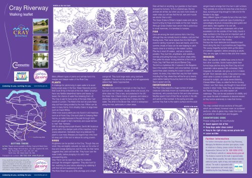
<strong>Cray</strong> <strong>Riverway</strong> Walk<br />
GETTING THERE<br />
by Train: Regular service available to <strong>Bexley</strong>, <strong>Cray</strong>ford & Slade Green.<br />
by Bus: <strong>Bexley</strong> Village: B15 (not Sun), 132, 492. <strong>Cray</strong>ford: 96, 428,<br />
492. Foots <strong>Cray</strong>: R11, N21, 233, 321, 492.<br />
North <strong>Cray</strong>: 492. Slade Green: 89, 469.<br />
Transport for London: 020 7222 1234 www.tfl.gov.uk<br />
If you would like to know more about the<br />
services the <strong>Council</strong> provides, or would like<br />
either a translation of this document or the<br />
information in a different format, please call our<br />
Customer Contact Centre on 020 8303 7777<br />
and press 0, quoting reference: 602521/7.07<br />
Listening to you, working for you www.bexley.gov.uk<br />
Wildlife on the river bank<br />
Many different types of plants and animals live in the<br />
margins and deeper water of the River <strong>Cray</strong>.<br />
PLANTS<br />
A challenge for plants living in open water is to avoid<br />
being swept away in the flow. Water Starworts anchor<br />
their roots firmly in the bed of the river. Water Crowfoot<br />
have very flexible streamlined stems and leaves, to<br />
lessen the chance of water flow breaking them off.<br />
The <strong>Cray</strong> is said to have some of the best Alder Carr<br />
woods in London. The Alder’s fine root structure helps<br />
stop soil from being eroded by the river. Willow can be<br />
seen in many forms, from shrubby Osiers to large trees<br />
such as Crack Willow.<br />
Other more scarce plants are only found in old meadows<br />
such as at Foots <strong>Cray</strong>. One such plant is Creeping Restharrow,<br />
so called because in the past its tough roots<br />
would get caught in farm machinery and cause farmers<br />
to ‘rest’ their ‘harrows’.<br />
With its striking blue-purple flowers, Devil’s Bit Scabious<br />
grows well in the damper parts of the meadows, but is<br />
scarce elsewhere. Herbalists have long believed the<br />
plant to cure many illnesses and legend has it the Devil<br />
bit away part of the root to reduce its curing powers.<br />
BIRDS<br />
Kingfishers can be spotted on the <strong>Cray</strong>. Though they are<br />
small, they are brightly coloured, so look out for a blur of<br />
blue and orange darting low over the river. As their name<br />
suggests they catch and eat fish. They hover over the<br />
water briefly, before plunging in to catch their<br />
unsuspecting prey.<br />
Grey Heron can be seen too, near the riverbank<br />
amongst the emergent vegetation. They also hunt for<br />
fish, watching for prey before attacking by stabbing it<br />
with their bill and swallowing it whole.<br />
The Mute Swan has pure white plumage and a bright<br />
orange bill. They build large nests using riverbank<br />
vegetation. They are not shy animals, and will aggressively<br />
defend their nests if approached.<br />
ANIMALS<br />
The two most common mammals on the <strong>Cray</strong> live in<br />
burrows on the riverbank. Usually where one occurs, the<br />
other does not. One is rare, and protected in the UK:<br />
the Water Vole. It feeds mainly on grasses and makes a<br />
distinctive ‘plopping’ sounds when it drops into the<br />
water. The other is the Brown Rat, which is widespread<br />
along the river, particularly in urban areas.<br />
Rats will feed on anything, but gravitate to food waste<br />
dropped by humans. To the untrained eye, the two<br />
animals are similar, but when you look more closely at<br />
water voles you will see that the tail, ears and muzzle<br />
are shorter than a rat’s.<br />
The Grass Snake is Britain’s largest snake and can be<br />
found hunting for frogs and toads on the river margins.<br />
Although Grass Snakes have venom that is poisonous<br />
to small mammals, it is harmless to humans.<br />
FISH<br />
Dace are among the most common fish in the <strong>Cray</strong>,<br />
although they are normally found in shallow, cold and fast<br />
flowing rivers. Their name derives from the Old English<br />
word for darting movement. Dace eat insects, and in the<br />
summer, shoals of Dace can be seen leaping to catch<br />
insects close to or landing on the waters’ surface.<br />
Pike live in most UK waters, and are a voracious<br />
predator. They hunt fish, amphibians, and waterfowl,<br />
normally ambushing their prey in a short, sharp strike.<br />
Pike prefer the slower moving stretches of the river, at<br />
Foots <strong>Cray</strong>, Hall Place and around Barnes <strong>Cray</strong>.<br />
The Eel is a mysterious fish. It spawns in the Sargasso<br />
Sea in the western Atlantic, and once hatched, its larvae<br />
spend three years crossing the ocean to reach UK<br />
waters. As elvers, they make their way into fresh waters,<br />
including the <strong>Cray</strong>, where they will live for up to twenty<br />
years before making the journey back to the Sargasso<br />
Sea to spawn and die.<br />
INVERTEBRATES<br />
The River <strong>Cray</strong> supports a huge number of small<br />
creatures collectively known as invertebrates (without a<br />
backbone), who provide food for fish and other animals.<br />
Mayflies spend most of their life as nymphs in the silts<br />
and sands of the riverbed. In the spring and early<br />
summer they float to the water’s surface and the adult<br />
Wildlife in the water<br />
winged insects emerge from the river in vast numbers.<br />
They normally do not live for more than a few hours or<br />
days, surviving just long enough to mate and for the<br />
females to lay eggs.<br />
Many different types of Caddis fly live in the river. Each<br />
species constructs a particular type of protecting or<br />
camouflaging structure, incorporating sand grains and<br />
plant debris, held together in its own silk.<br />
Freshwater Shrimps are crustaceans with a hard<br />
exoskeleton (on the outside of their body), found in<br />
large numbers in the <strong>Cray</strong> and an important part of<br />
the food chain. Shrimps must stay in water or they<br />
lose the moisture from their bodies.<br />
Perhaps the most distinctive and beautiful insect<br />
found along the river in summertime are Dragonflies.<br />
The young dragonfly nymphs climb up the stems<br />
of riverbank vegetation, before emerging as adults.<br />
They are very agile, to feed on flies and other insects.<br />
INVADERS<br />
Many new species of wildlife have come to the UK<br />
from other countries. Some invasive plants have<br />
formed large patches along the River <strong>Cray</strong> and will<br />
overwhelm native species if left unchecked. Giant<br />
Hogweed, for example, can grow up to 3. 5 meters<br />
tall with 10cm diameter stems. It has poisonous sap,<br />
which when it comes in contact with skin and<br />
exposed to sunlight, can cause severe blistering.<br />
Chinese Mitten Crabs, so called for the fur forming<br />
‘mittens’ over their claws, are thought to have arrived<br />
recently in ships’ holds. Today they are widespread in<br />
the Thames Estuary, and other eastern UK<br />
waterways. They can be real problems for wildlife, and<br />
can cause the side of riverbanks to become eroded<br />
as they burrow extensively to make their homes.<br />
SUITABILITY<br />
The map overleaf shows sections of the path<br />
which are surfaced, however even on surfaced<br />
sections, stiles & gates may make the route<br />
unsuitable for wheelchairs and buggies.<br />
COUNTRYSIDE CODE<br />
Please safeguard the countryside:<br />
• Guard against risk of fire<br />
• Keep dogs under close control<br />
• Keep to the right of way across private land<br />
• Leave no litter<br />
Further Information<br />
For further information about the <strong>Cray</strong> <strong>Riverway</strong>,<br />
Managing the Marshes and other open spaces, routes<br />
or initiatives in <strong>Bexley</strong>, please contact the <strong>Bexley</strong><br />
Regeneration Delivery Unit Tel: 020 8294 6742<br />
or visit <strong>Bexley</strong>’s website on www.bexley.gov.uk<br />
The distance covered by this walk is approximately<br />
10 miles. Where possible, the route follows riverside<br />
walks but parks, rights of way, and roads are also<br />
utilized. The walk is signposted with<br />
timber waymarkers and metal signs,<br />
identified by the <strong>Cray</strong> <strong>Riverway</strong> logo.
The <strong>Cray</strong> <strong>Riverway</strong> is a 16km (10 mile) path following<br />
the River <strong>Cray</strong> to the Thames from Foots <strong>Cray</strong><br />
Meadows in the south to Erith in the north. The route<br />
is signposted throughout, but much of it is along unsurfaced<br />
paths and may present some difficulties for<br />
pushchairs, wheelchairs or those with less mobility.<br />
All Saints Church to Water Lane<br />
The <strong>Riverway</strong> starts as you enter Foots <strong>Cray</strong> Meadows<br />
from Rectory Lane, just south of All Saints Church.<br />
All Saints Church and Foots <strong>Cray</strong> Meadows<br />
All Saints Church marks the entrance to Foots <strong>Cray</strong><br />
Meadows, and the start of the <strong>Cray</strong> <strong>Riverway</strong>. Thought<br />
to have been a site of worship since Norman times,<br />
Foots <strong>Cray</strong> takes its name from Godwin Fot, a local<br />
Saxon landowner recorded in the Domesday Book of<br />
1086, and from the River <strong>Cray</strong> that flowed through his<br />
land. Foots <strong>Cray</strong> Meadows were laid out as the<br />
grounds to two 18th century estates, Foots <strong>Cray</strong><br />
Place and North <strong>Cray</strong> Place. The open grasslands of<br />
Foots <strong>Cray</strong> Meadows are managed to support a wide<br />
variety of wildflowers and grasses. This has been vital<br />
in conserving the biodiversity we can see today.<br />
Continue along the waymarked rough track, crossing<br />
the river at Penny Farthing Bridge. The route follows<br />
the southern bank of the river past Five Arch Bridge.<br />
Five Arch Bridge<br />
Five Arch Bridge was once in the grounds of North<br />
<strong>Cray</strong> Place, in a parkland setting designed by<br />
Lancelot ‘Capability’ Brown. Formal geometric<br />
gardens favoured in the earlier Jacobean period<br />
were swept away and replaced with the ‘naturalistic’<br />
gardens in fashion at the time. These new ‘Arcadian’<br />
landscapes were designed to evoke a<br />
classical idea of perfection; with grand<br />
sweeping lawns, tree lined vistas and<br />
lakes. The River <strong>Cray</strong> was dammed to<br />
create the meandering lake lying at the<br />
end of the park, where Five Arch<br />
Bridge still stands.<br />
Continue <strong>walking</strong> past ‘The Alders’,<br />
a block of woodland on the northern<br />
bank, until the route divides into two<br />
separate routes (A & B) at a signposted<br />
footbridge at the end of<br />
Water Lane.<br />
Water Lane to Hall Place<br />
Route A avoids built up areas, and<br />
Route B passes through the historic<br />
centre of Old <strong>Bexley</strong>.<br />
Route A<br />
Turn right at the footbridge and<br />
continue along Water Lane to meet<br />
North <strong>Cray</strong> Road at Loring Hall. Turn left along North<br />
<strong>Cray</strong> Road following signs. At the roundabout follow<br />
the metal signs back along the south side of North<br />
<strong>Cray</strong> Road and after the Garden Centre, turn left<br />
uphill on the rough track, and follow waymarkers,<br />
passing Mount Mascal Stables, and beautiful views<br />
of Joyden’s Wood. Continue along the path and cross<br />
Vicarage Road entering Churchfield Wood.The<br />
waymarked path follows the perimeter of Churchfield<br />
Wood passing beneath the A2 and entering into Hall<br />
Place Recreation Ground. Keep following waymarkers<br />
and cross over the footbridge on the River <strong>Cray</strong>, where<br />
Routes A & B meet.<br />
Route B<br />
Turn left over the footbridge and walk along the path<br />
until you meet Riverside Road. Turn right and follow<br />
the finger posts for the <strong>Cray</strong> <strong>Riverway</strong>, across farmland.<br />
Following the waymarked track past <strong>Bexley</strong> Cricket<br />
Club, pass under the railway and continue along Tanyard<br />
Lane into <strong>Bexley</strong> High Street, (<strong>Bexley</strong> Station 2 mins<br />
walk). Turn right along the High Street and cross at<br />
the crossing. Turn left into Bourne Road, and cross<br />
that at the crossing. Follow Bourne Road, passing the<br />
Recreation Ground on your right. Cross over the A2<br />
as signed and follow the road past the roundabout (look<br />
for the view of Hall Place) to the entrance of Hall Place.<br />
Follow signs and waymarkers to the River <strong>Cray</strong>.<br />
Hall Place<br />
The present Hall Place Mansion was first built during the<br />
reign of Henry VIII, in about 1540 for Sir John Champneys,<br />
a merchant and former Lord Mayor of London. The<br />
gardens date from the early 20th Century featuring a<br />
rose garden, a topiary, a grass maze, herb garden, a<br />
formal sunken garden, a walled kitchen garden, and<br />
sub tropical plant houses. There is a café near the car<br />
park which serves light refreshments. The house and<br />
its gardens were extensively restored by <strong>Bexley</strong> <strong>Council</strong><br />
and are open to the public. Hall Place is now managed<br />
by <strong>Bexley</strong> Heritage Trust.<br />
Hall Place to Thames Road<br />
Continue beside the river until the<br />
northern end of the recreation ground<br />
and follow the boundary of the ground<br />
to join Bourne Road. The route follows<br />
Bourne Road passing Bourne Industrial<br />
Park on the right side to join London<br />
Road. Continue along London Road<br />
following signs and cross over <strong>Cray</strong>ford<br />
Bridge, continuing along <strong>Cray</strong>ford Way,<br />
past Waterside Gardens.<br />
<strong>Cray</strong> <strong>Riverway</strong><br />
<strong>Cray</strong>ford<br />
Calico bleaching and printing industry came to the town<br />
in the 1820’s, followed by carpet making and a tannery.<br />
The Maxim, later Vickers factories were established in<br />
1896, making machine guns, shells, fuses and cartridge<br />
cases. During the First World War aircraft, including the<br />
Vickers Gun bus and parts for the Vimy bomber were<br />
made here. 14,000 people worked in the factories by<br />
the end of the war. The houses along <strong>Cray</strong>ford Way<br />
were built to house workers. The Princess Theatre<br />
was built by the company, opening in July 1916, but<br />
was burnt down in December, reopening as a cinema<br />
in July 1919. The building was demolished in the late<br />
1950’s and is now the site of the 1960’s housing block<br />
opposite Waterside Gardens. The Vicker’s factory closed<br />
in the 1950’s, being converted into the sites of industrial<br />
estates and the Retail Park.<br />
At the end of Waterside Gardens, cross <strong>Cray</strong>ford Way<br />
and continue along waymarked track beside the River<br />
<strong>Cray</strong> where it meets Barnes <strong>Cray</strong> Road. Continue along<br />
Barnes <strong>Cray</strong> Road and turn right onto Maiden Lane.<br />
Walk along Maiden Lane and join the path along the<br />
south side of the river. Continue along the path beside<br />
the River <strong>Cray</strong> and at the end of the path turn left onto<br />
Thames Road.<br />
The Marshes<br />
Cross Thames Road and follow signed path<br />
through the industrial area of Saw Mills<br />
to <strong>Cray</strong>ford Creek where the River <strong>Cray</strong><br />
meets the River Darent. The path then<br />
follows perimeter of <strong>Cray</strong>ford Marsh,<br />
along the River Darent giving<br />
extensive views across<br />
Dartford Marsh, the<br />
Darent Flood Barrier<br />
and the River<br />
Thames.<br />
The marsh path ends by Erith<br />
Yacht Club; continue to Manor Road.<br />
The <strong>Cray</strong> <strong>Riverway</strong> finishes at the<br />
junction with Slade Green Road and<br />
Manor Road (Buses) and if walkers<br />
wish to continue to Erith they may take<br />
the Thames Path to Erith Town Centre.<br />
Saw Mills<br />
This is the historic name for the industrial<br />
area between Thames Road (A206) and<br />
<strong>Cray</strong>ford Marsh. Many local road names are<br />
derived from the timber mills that were situated<br />
here in the 1840s. Industry thrived here from as<br />
early as the 16th Century when a mill for making<br />
iron sheet and armour was set up to use the river<br />
for power. Since the 1700s the area was also<br />
where much of the cloth bleaching took place, a key<br />
part of the local textiles industry. Just beyond the<br />
Thames Road bridge was the old millpond, the site<br />
in the 1900s of the Vitbe Flour Mill and a chemical<br />
works. Both had water wheels to power<br />
their machinery.<br />
Thames Road<br />
The inter war years were a time<br />
of high unemployment. In 1921,<br />
construction began on Thames Road<br />
as part of a Government sponsored<br />
road building programme. Many unemployed<br />
ex–servicemen were recruited<br />
for the work. Before Thames Road opened in<br />
1923, Iron Mill Lane was the only land route to<br />
Saw Mills, and it was virtually impassable in the winter.<br />
Sailing barges transported heavy goods, coming from<br />
the Thames down the River Darent and along <strong>Cray</strong>ford<br />
Creek. The river remained a significant corridor for<br />
industry until recent times. Records of tolls levied in<br />
1977 show 400 tons of grain a week was brought along<br />
<strong>Cray</strong>ford Creek for processing at Saw Mills.<br />
<strong>Cray</strong>ford Marsh<br />
The marshes have been used<br />
for grazing and rough pasture since<br />
the beginning of the 15th Century.<br />
Tenants were required to pay 6d<br />
(half a shilling) per acre to help pay<br />
for the upkeep of marshland walls,<br />
dykes and fences. Other uses have<br />
relied on the relative isolation of the<br />
marshes and access to river transport. For example<br />
the area where Darent Industrial Estate now stands<br />
was the former site of ammunition works, in use from<br />
1889 to 1962. It was an ideal place for the storage<br />
and manufacture of explosives and armaments.<br />
For more information on the marshes visit<br />
www.managingthemarshes.org.uk<br />
Other walks in the area; The London Outer Orbital Path<br />
(Loop) and the Shuttle <strong>Riverway</strong>.