

Tree identification manual - North East Downs Landcare Group
Tree identification manual - North East Downs Landcare Group
Tree identification manual - North East Downs Landcare Group

Create successful ePaper yourself
Turn your PDF publications into a flip-book with our unique Google optimized e-Paper software.
Introduction<br />
Within the north-east Darling <strong>Downs</strong> there is a range of land systems and associated tree species. This<br />
<strong>manual</strong> has been complied to provide information on the major species occurring in the district to allow their<br />
<strong>identification</strong> in the field.<br />
Plants can be identified either by a simple key, tree descriptions or illustrations.<br />
The descriptions outline a number of features which include the locality and distribution of the trees with<br />
regards to land systems and their associated soil type. Each tree is described in simple language in terms of<br />
botanical characteristics as well as information on distinctive features and the location of example trees in<br />
the district.<br />
This <strong>manual</strong> is not designed as a complete tree list, only the more common native species that occur in the<br />
district are described. Additional lists are provided on associated or less common species in the district and a<br />
list of introduced species commonly planted around farms in the district.<br />
A complete index of both common species names and scientific names can be found on pages 89 and 90.<br />
The trees have been arranged in groups based loosely on similar structures, form, and locality.<br />
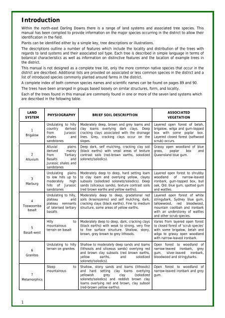
Each of the trees found in this <strong>manual</strong> are commonly found in one or more of the seven land systems which<br />
are described in the following table.<br />
1<br />
LAND<br />
SYSTEM<br />
1<br />
Brigalow<br />
2<br />
Alluvium<br />
3<br />
Marburg<br />
4<br />
Toowoomba<br />
basalt<br />
5<br />
Basalt-west<br />
6<br />
Granites<br />
7<br />
Metamorphics<br />
PHYSIOGRAPHY BRIEF SOIL DESCRIPTION<br />
Undulating to hilly<br />
country derived<br />
from Jurassic<br />
shales and<br />
sandstones<br />
Alluvial plains<br />
derived mainly<br />
from Tertiary<br />
Basalts and<br />
Jurassic shales and<br />
sandstones<br />
Undulating plains<br />
to low hills up to<br />
moderately high<br />
hills of Jurassic<br />
sandstones<br />
Undulating to hilly,<br />
plateau and<br />
plateau remnants<br />
of laterised tertiary<br />
basalts<br />
Hilly to<br />
mountainous<br />
terrain on basalt<br />
Undulating to hilly<br />
terrain on granites<br />
Steep to<br />
mountainous<br />
Moderately deep, brown and grey loams and<br />
clay loams overlying dark clays. Deep<br />
cracking clays associated with the drainage<br />
lines. Grey, cracking clays occur on the<br />
slopes.<br />
Deep dark, self mulching, cracking clay soil<br />
(black earths) with small areas of texture<br />
contrast soils (red-brown earths, solodized<br />
solonetz/solodics).<br />
Moderately deep to deep, hard setting loam<br />
to clay loam and overlying yellow, clayey<br />
subsoils (solodized solonetz/solodics). Deep<br />
sands (siliceous sands), texture contrast soils<br />
(red brown earths and yellow earths).<br />
Moderately deep to deep, gradational red<br />
soils (krasnozems) and self mulching, dark,<br />
cracking clays (black earths). Fine to medium<br />
structure, some areas of yellow earths.<br />
Moderately deep to deep, dark, cracking clays<br />
(black earths) with weak to strong, very fine<br />
to fine surface structure. Shallow, stony,<br />
brown, grey brown to grey lithosols.<br />
Shallow to moderately deep sands and loams<br />
(lithosols and siliceous sands) overlying red<br />
and brown clay subsoils (red brown earths,<br />
yellow earths, and solodized<br />
solonetz/solodics).<br />
Shallow, stony sands and loams (lithosols)<br />
and hard setting clay loams overlying<br />
yellowish grey clay (solodized<br />
solonetz/solodics) and reddish brown clay<br />
loams overlying red and brown, clay subsoil<br />
(red-brown yellow earths).<br />
ASSOCIATED<br />
VEGETATION<br />
Layered open forest of belah,<br />
brigalow, wilga and gum-topped<br />
box with some poplar box.<br />
Layered closed forest (softwood<br />
scrub) occurs.<br />
Grassy open woodland of blue<br />
grass, poplar box and<br />
Queensland blue gum.<br />
Layered open forest to shrubby<br />
woodland of narrow-leaved<br />
ironbark, gum-topped box, bull<br />
oak, Qld. blue gum, spotted gum<br />
and wattles.<br />
Layered open forest of white<br />
stringybark, Sydney blue gum,<br />
tallowwood, red bloodwood,<br />
mountain coolibah and ironbark<br />
with an understorey of wattles<br />
and other scrub species.<br />
Varies from layered open forest<br />
to closed forest of 'scrub species'<br />
with some brigalow, belah and<br />
wilga to grassy open woodland<br />
with narrow-leaved ironbark.<br />
Open forest to woodland of<br />
narrow-leaved ironbark, grey<br />
gum, silver-leaved ironbark,<br />
bloodwood and stringybarks.<br />
Open forest to woodland of<br />
narrow-leaved ironbark and grey<br />
gum.