PDMS Well Symbols Table - Indiana Geological Survey
PDMS Well Symbols Table - Indiana Geological Survey
PDMS Well Symbols Table - Indiana Geological Survey

Create successful ePaper yourself
Turn your PDF publications into a flip-book with our unique Google optimized e-Paper software.
<strong>PDMS</strong> <strong>Well</strong> <strong>Symbols</strong> <strong>Table</strong><br />
Symbol Scheme<br />
<strong>PDMS</strong> <strong>Well</strong> Symbol <strong>Table</strong><br />
<strong>Indiana</strong> <strong>Geological</strong> <strong>Survey</strong> 12/8/2010<br />
A graphic symbol is used to indicate the location and "designation" of a well on IGS maps. The IGS Petroleum <strong>Well</strong><br />
<strong>Symbols</strong> are similar to those used in the petroleum industry and by other geological surveys, although no recognized<br />
standard exists.<br />
A well's Symbol designation is based on its status and history. The symbol scheme employs a set of basic symbols to<br />
which "modifiers" can be added to impart additional information. This scheme is explained in the IGS Petroleum <strong>Well</strong><br />
Symbol Explanation.<br />
Symbol Codes<br />
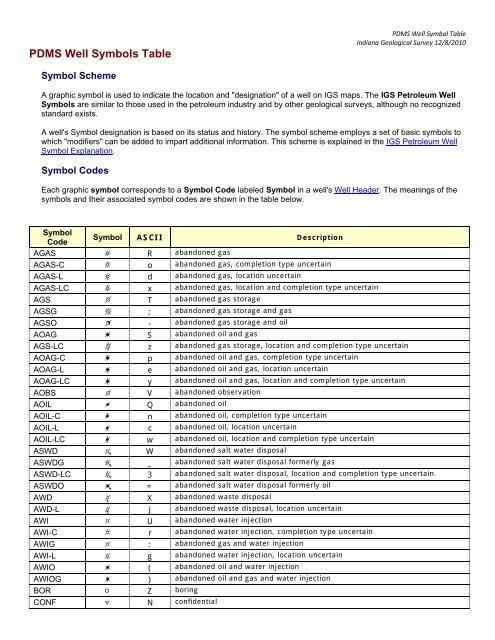
Each graphic symbol corresponds to a Symbol Code labeled Symbol in a well's <strong>Well</strong> Header. The meanings of the<br />
symbols and their associated symbol codes are shown in the table below.<br />
Symbol<br />
Code<br />
Symbol ASCII Description<br />
AGAS R abandoned gas<br />
AGAS-C o abandoned gas, completion type uncertain<br />
AGAS-L d abandoned gas, location uncertain<br />
AGAS-LC x abandoned gas, location and completion type uncertain<br />
AGS T abandoned gas storage<br />
AGSG ; abandoned gas storage and gas<br />
AGSO - abandoned gas storage and oil<br />
AOAG S abandoned oil and gas<br />
AGS-LC z abandoned gas storage, location and completion type uncertain<br />
AOAG-C p abandoned oil and gas, completion type uncertain<br />
AOAG-L e abandoned oil and gas, location uncertain<br />
AOAG-LC y abandoned oil and gas, location and completion type uncertain<br />
AOBS V abandoned observation<br />
AOIL Q abandoned oil<br />
AOIL-C n abandoned oil, completion type uncertain<br />
AOIL-L c abandoned oil, location uncertain<br />
AOIL-LC w abandoned oil, location and completion type uncertain<br />
ASWD W abandoned salt water disposal<br />
ASWDG _ abandoned salt water disposal formerly gas<br />
ASWD-LC 3 abandoned salt water disposal, location and completion type uncertain<br />
ASWDO = abandoned salt water disposal formerly oil<br />
AWD X abandoned waste disposal<br />
AWD-L j abandoned waste disposal, location uncertain<br />
AWI U abandoned water injection<br />
AWI-C r abandoned water injection, completion type uncertain<br />
AWIG : abandoned gas and water injection<br />
AWI-L g abandoned water injection, location uncertain<br />
AWIO ( abandoned oil and water injection<br />
AWIOG ) abandoned oil and gas and water injection<br />
BOR Z boring<br />
CONF N confidential
<strong>PDMS</strong> <strong>Well</strong> Symbol <strong>Table</strong> page 2 <strong>Indiana</strong> <strong>Geological</strong> <strong>Survey</strong> 12/8/2010<br />
CWO ! confidential workover<br />
DRY P dry hole<br />
DRY-C m dry hole, completion type uncertain<br />
DRY-L b dry hole, location type uncertain<br />
DRY-LC v dry hole, location and completion type uncertain<br />
EXP a expired permit<br />
GAS B gas<br />
GS D gas storage<br />
GSG 6 gas storage formerly gas<br />
GSO 5 gas storage formerly oil<br />
LOC M permitted location<br />
MAP 8 nothing known, old Trenton well from map<br />
NPWS K non-potable water supply<br />
NPWSG ] non-potable water supply, formerly gas<br />
NPWSO [ non-potable water supply, formerly oil<br />
OAG C oil and gas<br />
OBG } observation formerly gas, or observation and gas<br />
OBGS " observation formerly gas storage<br />
OBS H observation<br />
OIL A oil<br />
PATH point along the path of a deviated hole (symbol is graphic -- not a True Type font)<br />
PWS L potable water supply<br />
STRT Y stratigraphic/structure test<br />
STRT-L k stratigraphic/structure test, location uncertain<br />
SURFACE { surface location of deviated hole<br />
SWD I salt water disposal<br />
SWDG 9 salt water disposal formerly gas<br />
SWDGS | salt water disposal formerly gas storage<br />
SWDO 0 salt water disposal formerly oil<br />
TAGAS f temporarily abandoned gas<br />
TAGS h temporarily abandoned gas storage<br />
TANEW O temporarily abandoned new well<br />
TAOBS 4 temporarily abandoned observation<br />
TAOG l temporarily abandoned oil and gas<br />
TAOIL q temporarily abandoned oil<br />
TASTRT 7 temporarily abandoned stratigraphic/structure test<br />
TASWD i temporarily abandoned salt water disposal<br />
TAWD u temporarily abandoned waste disposal<br />
TAWI s temporarily abandoned water injection<br />
TAWS 1 temporarily abandoned non-potable water supply<br />
WD J waste disposal<br />
WI E water injection (waterflood)<br />
WIAG 2 water injection and gas production--dual completion<br />
WIAO t water injection and oil production--dual completion<br />
WIG G water injection formerly gas<br />
WIO F water injection formerly oil<br />
WIOG + water injection formerly oil and gas