River Severn - Canoe England
River Severn - Canoe England
River Severn - Canoe England

Create successful ePaper yourself
Turn your PDF publications into a flip-book with our unique Google optimized e-Paper software.
Navigation<br />
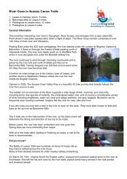
Once one of the great navigable rivers, the <strong>Severn</strong> is now used mainly by<br />
recreational boaters. The days of barges and trows are all gone and the modern<br />
<strong>Severn</strong> is travelled by canoes, kayaks, and small powerboats and in the lower<br />
reaches, by cruisers of all sizes.<br />
At times of flood the <strong>Severn</strong> can rise rapidly, particularly in the upper reaches and can<br />
reach a level of over five metres above its normal summer height. It is not uncommon for<br />
the river to rise higher than its banks and spread out over the surrounding floodplain<br />
several times in the course of a normal winter. Flash floods can occur in the summer.<br />
Although navigation brought trade and wealth to the inland towns along its course, it<br />
was never totally reliable, being dependent upon the level of water, which was often too<br />
low in summer and flooded in winter. A tow path, which ran alongside the river, was used<br />
for hauling boats upstream, firstly by gangs of men and later by horses. Trade<br />
varied throughout the centuries eventually falling into decline perhaps with the advent of<br />
the railways.<br />
Access<br />
The public right of navigation existing on the <strong>Severn</strong> gives everyone the right to<br />
navigate from Pool Quay, near Welshpool, to Stourport. From Pool Quay to<br />
Stourport the river is generally hazard free, with the exception of Shrewsbury Weir<br />
and the rapids at Jackfield and Eymore. From Stourport to Gloucester, British<br />
Waterways are the navigation authority and a licence is required. The right of<br />
navigation, however, does not give the canoeist the right to cross privately owned<br />
land or launch a boat without landowner permission.<br />
4.