MODULE 6 - BOATsmart!
MODULE 6 - BOATsmart!
MODULE 6 - BOATsmart!

You also want an ePaper? Increase the reach of your titles
YUMPU automatically turns print PDFs into web optimized ePapers that Google loves.
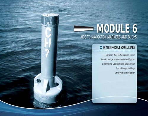
<strong>MODULE</strong> 6<br />
AIDS TO NAVIGATION MARKERS AND BUOYS<br />
IN THIS <strong>MODULE</strong> YOU’LL LEARN<br />
Canada’s Aids to Navigation system<br />
How to navigate using the Lateral System<br />
Determining Upstream and Downstream<br />
Special buoys and flags<br />
Other Aids to Navigation
Aids to navigation<br />
“Aids to Navigation” are the system of buoys and<br />
markers that assist a boater in determining his or<br />
her position and identifying potential dangers and<br />
waterway obstructions. External to pleasure craft,<br />
aids to Navigation can be used to plot position<br />
and course on nautical charts and other nautical<br />
publications. Aids to navigation also assist the<br />
pleasure craft operator in choosing the most preferred<br />
and safest route.<br />
It is prohibited under the Criminal Code of Canada<br />
to interfere with any aid to navigation. Operators<br />
should never tie up to a marker, buoy or any other<br />
aid to navigation. In addition, no person may wilfully<br />
alter, remove or conceal a signal, buoy or other type of<br />
navigation marker.<br />
Two main systems of navigation are used on Canadian<br />
Waterways: The Lateral System and the Cardinal<br />
System. All aids to navigation have identifying marks<br />
such as colours, lights and numbers.<br />
What is a buoy?<br />
A buoy is a floating marker or signal which is affixed<br />
to the bottom of the waterway or mounted on a<br />
feature (such as an island) of the waterway.<br />
Buoys serve four main functions:<br />
- Provide Warnings<br />
- Provide Information<br />
- Mark underwater hazards<br />
- Provide a system for navigation<br />
Floating buoys<br />
There are three styles of floating buoys used on<br />
Canadian waterways:<br />
1) Light Buoys: Light buoys are typically the largest<br />
of all floating buoys and have a light fixture<br />
affixed to the top of the buoy.<br />
2) Spar Buoys: Spar buoys are also called “pillars”<br />
and are common on smaller waterways. They have<br />
a cylinder shape and are typically smaller than<br />
light buoys.<br />
3) Cans: Cans are wider than spar buoys and<br />
are typically used as lateral ateral system and<br />
bifurcation buoys.<br />
All floating buoys are affixed xed to the bottom<br />
of the waterway using a structure tructure of<br />
underwater cables and anchors. chors.<br />
Systems of buoys in Canada<br />
There are several systems of buoys and markers used<br />
on Canadian waterways to aid in navigation:<br />
1) The Lateral System is a system of red and green<br />
buoys used to mark preferred safe routes. The<br />
Lateral System also includes fairway buoys,<br />
isolated danger buoys and day beacons.<br />
2) The Cardinal System consists of yellow and black<br />
buoys that indicate safe routes by the cardinal<br />
compass points.<br />
3) A Range is a series of two buoys that, when<br />
aligned align along a sight path, indicate the safest<br />
route for navigation.<br />
4) Special Specia Purpose Buoys may be yellow or white in<br />
colour colou and are used to mark dangers such as<br />
(but not limited to) racecourses, underwater<br />
structures, struc<br />
pipelines, etc.<br />
AIDS TO NAVIGATION<br />
Module 6 I 101
THE LATERAL SYSTEM<br />
102 I Module 6<br />
The lateral system<br />
The lateral system is used to mark the most preferred<br />
and safest routes. Consisting of red and green buoys,<br />
this system marks the course of deepest water and<br />
indicates on which side of the buoy boaters should<br />
safely pass.<br />
In the Lateral System, buoys and beacons indicate the<br />
sides of the channel or route relative to a conventional<br />
direction of buoyage (usually upstream). They also<br />
mark junctions (a point where two channels meet) or<br />
bifurcations (the point where a channel divides). They<br />
can also mark a place where two tributaries meet.<br />
There are two main types of Lateral System buoys<br />
which are most familiar to boaters:<br />
- Green Port-hand buoys<br />
- Red Starboard-hand buoys<br />
In total, there are six types of lateral buoys including:<br />
port hand buoys, starboard hand buoys, port<br />
bifurcation buoys, starboard bifurcation buoys, fairway<br />
buoys, and isolated danger buoys. The Lateral System<br />
is standardized for international waterways.<br />
Port-hand buoys<br />
Port-hand buoys are green in colour and mark the<br />
left side of a channel or the location of a specific<br />
danger. Port-hand buoys must be kept on the<br />
left-hand side of your boat when heading upstream.<br />
Port-hand buoys are identified by letter(s) and odddigit<br />
number(s), and in standard configuration, are<br />
flat on the top. In some instances, a port-hand buoy<br />
may be fitted with a top-mark consisting of a single<br />
green cylinder.<br />
Port-hand buoys may also be fitted with a green light<br />
that flashes in either a:<br />
- F1 pattern (single flashes in 4 second intervals); or<br />
- Q pattern (quick single flashes one second apart)<br />
Starboard-hand buoys<br />
Starboard-hand buoys are red in colour and mark<br />
the right side of a channel or the location of a<br />
specific danger. Starboard-hand buoys must be<br />
kept on the right-hand side of your boat when<br />
heading upstream.<br />
Starboard-hand buoys are identified by letter(s) and<br />
even-digit number(s) and in standard configuration,<br />
are pointed on the top. If they do not have a red light<br />
they will be conical on the top.<br />
Starboard-hand buoys may also be fitted with a red<br />
light that flashes in either a:<br />
- F1 pattern (single flashes in 4 second intervals); or<br />
- Q pattern (quick single flashes one second apart)
Bifurcation buoys<br />
Part of the lateral system, bifurcation buoys indicate<br />
the junction of channels:<br />
- Port-Junction bifurcation buoys are green in colour<br />
with a red horizontal band at the midsection. Portjunction<br />
buoys mark the junction of two channels<br />
and should be kept on the port (left) side of the<br />
vessel when navigating upstream.<br />
- Starboard-Junction bifurcation buoys are red<br />
in colour with a green horizontal band at the<br />
midsection. Starboard-junction buoys mark the<br />
junction of two channels and should be kept on the<br />
starboard (right) side of the vessel when navigating<br />
upstream.<br />
DOWNSTREAM<br />
WHITE<br />
LIGHT<br />
Fairway buoys<br />
UPSTREAM<br />
Fairway buoys are used to mark the entrance to a<br />
channel, the centre of a shipping channel, or a safe<br />
approach to land. Vessels should keep the fairway<br />
buoy on the left (port) side whether proceeding<br />
upstream or downstream.<br />
Fairway buoys are identified by the following:<br />
- Red and white in colour, divided vertically with one<br />
side red and the other side white<br />
- Will have a ball shaped top-mark<br />
- May be equipped with a white light that flashes in<br />
a Mo(A) sequence – One short flash, followed by<br />
one long flash repeated 10 times per minute<br />
DOWNSTREAM<br />
WHITE<br />
LIGHT<br />
Isolated danger buoys<br />
UPSTREAM<br />
An isolated danger buoy is used to mark an isolated<br />
hazard or obstruction such as a rock, shoal or sunken<br />
island. The buoy will be moored on or above an<br />
isolated danger that has navigable (i.e. safe) water<br />
all around it. You should refer to a marine chart to<br />
determine the features of the isolated danger (i.e. size,<br />
depth, exact location etc.) and should navigate well<br />
clear of the marked danger.<br />
Isolated danger buoys are identified by the following:<br />
- Black in colour with a wide red band at<br />
the midpoint<br />
- A top mark consisting of two black balls<br />
- May be equipped with a white light that flashes in<br />
a FL(2) sequence – a two flash sequence repeated<br />
every 4 seconds<br />
THE LATERAL SYSTEM<br />
Module 6 I 103
DAY BEACONS<br />
104 I Module 6<br />
DAY BEACONS<br />
Day beacons are signs posted on land or water. They are not lighted and are intended for daytime use only. Day beacons utilize<br />
the same colours as the lateral system and are typically used as channel or hazard markers. They may be marked with reflective<br />
lettering for identification on marine charts.<br />
Port-Hand<br />
Day Beacon<br />
A port-hand day beacon consists of<br />
a black or green square on a white<br />
background framed by a reflective<br />
green border. A port-hand day<br />
beacon identifies the port (left)<br />
side of a channel or hazard and<br />
must be kept on the left side when<br />
proceeding upstream. Port-hand day<br />
beacons may display an odd number<br />
marked with reflective white lettering<br />
for reference on marine charts.<br />
Port-Junction<br />
Day Beacon<br />
A port-junction day beacon marks<br />
the junction of two channels and<br />
may be passed on either side. If the<br />
preferred channel is desired, the portjunction<br />
day beacon should be kept<br />
on the vessel’s port (left) side when<br />
travelling upstream.<br />
Starboard-Hand<br />
Day Beacon<br />
A starboard-hand day beacon<br />
consists of a red triangle on white<br />
background framed by a reflective<br />
red border. A starboard-hand day<br />
beacon identifies the starboard<br />
(right) side of the channel or hazard<br />
and must be kept on the right<br />
side when proceeding upstream.<br />
Starboard-hand day beacons may<br />
display an even number marked with<br />
reflective white lettering for reference<br />
on marine charts.<br />
Starboard-Junction<br />
Day Beacon<br />
A starboard-junction day beacon<br />
marks the junction of two channels<br />
and may be passed on either side. If<br />
the preferred channel is desired, the<br />
starboard-junction day beacon should<br />
be kept on the vessel’s starboard<br />
(right) side when travelling upstream.
RED RIGHT RETURNING HOW DO I DETERMINE WHICH WAY IS UPSTREAM?<br />
What side of a red starboard-hand<br />
buoy should you pass on? What<br />
about a green port-hand buoy?<br />
Doesn’t it depend on which direction<br />
you’re travelling? If you encounter a<br />
red or green buoy on an open body<br />
of water, which way do you go?<br />
These are some of the most common<br />
questions that boaters have. In fact,<br />
many boaters are not certain on<br />
which side of a marker buoy they<br />
should pass. A simple way to<br />
remember is to use the Red Right<br />
Returning memory aid:<br />
PROCEEDING EDINGG FROM<br />
SEAWARD OR<br />
UPSTREAM<br />
Red Right Returning refers to keeping the Red starboard-hand buoy<br />
on the Right side of your vessel when:<br />
- Heading upstream<br />
- When entering a channel from seaward<br />
- When returning upstream to headwaters or to harbour<br />
When traveling upstream:<br />
- Always keep the red starboard-hand buoy on the right side of your vessel<br />
- Always keep the green port-hand buoy on the left side of your vessel<br />
When traveling downstream:<br />
- Always keep the red starboard-hand buoy on the left side of your vessel<br />
- Always keep the green port-hand buoy on the right side of your vessel<br />
In order to apply the Red Right Returning Rule you will need to determine which<br />
direction is “Upstream” and which direction is “Downstream” - “Upstream” and<br />
“Downstream” refers to the direction of the current (i.e. the direction of water<br />
flow). Unfortunately, there is no one way to determine the direction of the current.<br />
For example, on “land-locked” lakes (i.e. lakes that are not connected by a river,<br />
canal system or other waterway) it can be very difficult to determine which direction<br />
is upstream and which is downstream. In many places, the direction of the current<br />
is determined by consensus or by the tide. On canal systems (such as Ontario’s Trent<br />
Severn Canal and Rideau Canal) the current changes direction at specific “high”<br />
points on the canal system. For example, from Ottawa, you rise with each lock going<br />
“upstream”. However, when you reach the Newboro Locks, you begin heading<br />
back “downstream” (even though you are still heading in the same direction). The<br />
direction of current can also change where lakes connect to one another. To help you<br />
determine the direction of water flow there are several tips to remember:<br />
- If you’re entering a channel from seaward (i.e. from the sea) you are considered<br />
to be travelling “upstream”<br />
- If you’re travelling on a sea channel that runs parallel to the coast, you<br />
should consider the “clockwise” direction as if it were “upstream” (i.e. in a<br />
Southerly direction along the Atlantic Coast and in a Northerly direction along<br />
the Pacific Coast)<br />
- Marine charts identify the upstream direction of travel. If you’re operating on<br />
a “land-locked” lake or a body of water on which you are unable to determine<br />
the direction of water flow, you can refer to a marine chart to identify the<br />
upstream direction of travel and the location of waterway hazards.<br />
LATERAL SYSTEM NAVIGATION<br />
Module 6 I 105
THE CARDINAL SYSTEM<br />
106 I Module 6<br />
The cardinal system<br />
The cardinal buoy system consists of yellow and black<br />
buoys that are used to assist boaters in identifying the<br />
location of safe water. Safe water lies on the North,<br />
South, East or West side of the buoys. For example,<br />
a North Cardinal Buoy indicates that safe water lies<br />
to the North of the buoy. Cardinal buoys may be<br />
equipped with a light and/or letters for identification<br />
on a marine chart. Remember: With cardinal buoys,<br />
safest water lies in the direction indicated by the<br />
buoy. Water in the opposite direction should be<br />
considered unsafe and avoided.<br />
Cardinal markers are spar or pillar shaped (with a<br />
flat top). The position of the yellow and black colour<br />
bands indicates the cardinal compass point of North,<br />
South, East or West and therefore the direction of the<br />
safest water. If so equipped, top-marks consisting of<br />
two cones indicate the direction of safe water. Specific<br />
details on each type of Cardinal Buoy can be found in<br />
the “Chart of Buoys” on page 109.<br />
CARDINAL BUOYS AND THEIR SIGNAL LIGHTS<br />
Cardinal buoys may be equipped with a flashing white light for reference when navigating at night.<br />
North flashes once; South flashes in a group six times followed by one long flash; East flashes in a group<br />
three times; and West flashes in a group nine times. The chart below depicts the pattern of flashing white light<br />
for each type of buoy.<br />
West buoys flash at<br />
the rate of 9 times in<br />
fifteen seconds. A very<br />
quick flash can also be<br />
used – 9 flashes every<br />
ten seconds<br />
W EST<br />
0 sec.<br />
15<br />
Q(9)15S<br />
0 sec.<br />
-VQ(9)10S<br />
OR<br />
10<br />
NW<br />
N ORTH<br />
S<br />
O UT<br />
H<br />
0 sec. 5 10 15<br />
(Q)1S<br />
OR<br />
0 sec. 5 10 15<br />
-(VQ).5S<br />
N<br />
0 sec.<br />
15<br />
(Q(6)+LF1)15S<br />
OR<br />
0 sec. 10<br />
(VQ(6)+LF1)10S<br />
WHITE<br />
LIGHT<br />
W E<br />
SW<br />
South buoys flash at a rate of 6 times in<br />
15 seconds followed by a single long flash.<br />
A very quick flash can also be used –<br />
6 flashes every ten seconds plus 1 longer<br />
flash at the end of each group to mark<br />
the end of a single flash cycle.<br />
WHITE<br />
LIGHT<br />
DANGER<br />
WHITE<br />
LIGHT<br />
S<br />
North buoys flash at a rate<br />
of 1 per second or 60 per<br />
minute. A very quick flash<br />
can also be used – 10 flashes<br />
every five seconds<br />
NE<br />
WHITE<br />
LIGHT<br />
SE<br />
E<br />
A ST<br />
0 sec.<br />
Q(3)10S<br />
OR<br />
0 sec. 5 10 15<br />
-VQ(3)5S<br />
10<br />
East buoys flash at the<br />
rate of 3 times every<br />
ten seconds. A very<br />
quick flash can also be<br />
used – 3 flashes every<br />
five seconds.
Range day beacons<br />
Ranges are typically used to guide larger vessels<br />
through a channel. Ranges consist of two or more<br />
markers, permanently affixed at a significant distance<br />
from each other. Ranges are constructed so that there<br />
is an upper marker and a lower marker. The lower<br />
marker is constructed near ground level at the shore<br />
while the upper marker is attached to a tower, located<br />
behind the lower marker. One navigates through<br />
the channel by maintaining a course that keeps one<br />
marker aligned top and bottom with the other. When<br />
the two markers are lined up vertically, the boater is<br />
on the recommended course.<br />
Boating restriction signs<br />
There are five shapes associated with boating<br />
restriction signs. Each boating restriction sign is<br />
framed in orange. The symbol on the sign indicates<br />
the type of restriction that applies. If the sign is arrow<br />
shaped, the restriction applies in the direction pointed<br />
by the arrow. Signs with a green border indicate that<br />
a special condition applies to the restriction.<br />
No internal combustion<br />
engine permitted<br />
Power Limit<br />
Standardized Speed Limit<br />
No vessels permitted<br />
No power driven vessels or vessels driven by<br />
electrical propulsion in the direction of the arrow<br />
No skiing north of the sign<br />
No power driven vessels or vessels driven by<br />
electrical propulsion during the hours and on<br />
days in red<br />
Special buoys and flags<br />
There are a variety of special buoys and flags that<br />
mark specific hazards and provide information to the<br />
operator. These markers may be equipped with lights<br />
and may be marked with letters or numbers for chart<br />
identification. Operators must learn and be able to<br />
identify each special buoy and flag (refer to Appendix<br />
C at the beginning of the next page for a description<br />
of special buoys and flags).<br />
Posted command signs<br />
Operators may encounter additional aids to navigation<br />
including command signs and warning signs. These<br />
signs may be posted either on land or in the water<br />
and may signify:<br />
- No-wake zones - No-anchorage areas<br />
- Speed-limit zones - Low-head dam hazards<br />
- Pipeline hazards - Power line hazards<br />
SPECIAL BUOYS AND FLAGS<br />
Module 6 I 107
APPENDIX C – CHART OF BUOYS AND FLAGS<br />
108 I Module 6<br />
PURPOSE<br />
COLOUR<br />
SHAPE<br />
IDENTIFICATION<br />
TOPMARK<br />
LIGHT<br />
North Cardinal Buoy South Cardinal Buoy East Cardinal Buoy West Cardinal Buoy Diving Buoy Swimming Buoys<br />
A North Cardinal Buoy is<br />
positioned so that the safest<br />
water lies to the North of<br />
the buoy<br />
Of the portion above the<br />
waterline, the buoy is black<br />
on the top and yellow on<br />
the bottom<br />
If the buoy is not equipped<br />
with a light, it will be<br />
normally spar shaped<br />
A South Cardinal Buoy is<br />
positioned so that the safest<br />
water lies to the South of<br />
the buoy<br />
Of the portion above the<br />
waterline, the buoy is yellow<br />
on the top and black on<br />
the bottom<br />
If the buoy is not equipped<br />
with a light, it will be<br />
normally spar shaped<br />
An East Cardinal Buoy is<br />
positioned so that the safest<br />
water lies to the East of<br />
the buoy<br />
Of the portion above the waterline,<br />
the buoy is coloured<br />
black with a wide yellow<br />
band around<br />
the midsection.<br />
If the buoy is not equipped<br />
with a light, it will be<br />
normally spar shaped<br />
A West Cardinal Buoy is<br />
positioned so that the safest<br />
water lies to the West of<br />
the buoy<br />
Of the portion above the<br />
waterline, the buoy is<br />
coloured yellow with a wide<br />
black band around<br />
the midsection<br />
If the buoy is not equipped<br />
with a light, it will be<br />
normally spar shaped<br />
Diving buoys mark an area<br />
where scuba diving (or other<br />
such diving activities) are<br />
taking place<br />
White White<br />
Various Various<br />
Letters only Letters only Letters only Letters only None None<br />
Two black cones, stacked on<br />
top of each other, pointing<br />
upwards<br />
A white light fl ashing in a<br />
Quick (Q) sequence every<br />
1 second or in a Very Quick<br />
(VQ) sequence every<br />
0.5 seconds<br />
Two black cones, stacked on<br />
of top of each other, pointing<br />
downwards<br />
A white light fl ashing in a<br />
(Q(6) + LF1) 15s sequence<br />
consisting of a group six<br />
quick single fl ashes followed<br />
by one long fl ash repeated<br />
every 15 seconds, or in a<br />
(VQ(6) + LF1) 10s sequence<br />
consisting of a group of six<br />
very quick single fl ashes<br />
followed by one long fl ash<br />
repeated every 10 seconds<br />
Two black cones, stacked on<br />
top of each other, with the<br />
bottom one pointing down<br />
and the top one pointing up<br />
A white light fl ashing in a<br />
Q(3) 10s sequence consisting<br />
of a group of three quick<br />
single fl ashes repeated every<br />
10 seconds, or in a VQ(3)<br />
5s sequence consisting of a<br />
group of three very quick<br />
single fl ashes repeated every<br />
5 seconds<br />
Two black cones, stacked on<br />
top of each other, with the<br />
bottom one pointing up and<br />
the top one pointing down<br />
A white light fl ashing in a<br />
Q(9)15s sequence consisting<br />
of a group of nine quick<br />
single fl ashes repeated every<br />
15 seconds, or in a VQ(9)<br />
5s sequence consisting of a<br />
group of nine very quick<br />
single fl ashes repeated every<br />
5 seconds<br />
Carries a red fl ag not less<br />
than 50 cm square with a<br />
white diagonal stripe<br />
Swimming buoys mark the<br />
perimeter of swimming areas<br />
None<br />
None May carry a yellow light<br />
that fl ashes in a (F1)<br />
4s sequence
PURPOSE<br />
COLOUR<br />
SHAPE<br />
IDENTIFICATION<br />
TOPMARK<br />
LIGHT<br />
Keep Out Buoy Control Buoy Information Buoy Hazard Buoy Cautionary Buoy Anchorage Buoy<br />
Keep out buoys mark an<br />
area of water where boats<br />
are prohibited<br />
White with an orange<br />
diamond containing an<br />
orange cross on two opposite<br />
sides and two orange<br />
horizontal bands, one above<br />
and one below the<br />
diamond symbols<br />
Various including:<br />
Light buoys, spar-shaped,<br />
and cans<br />
Control buoys mark an<br />
areaof water where boating<br />
is restricted<br />
White with an orange open<br />
faced circle on two opposite<br />
sides and two horizontal<br />
orange bands, one above<br />
and below the circles. A black<br />
fi gure or symbol inside the<br />
orange circles indicates the<br />
type of restriction in effect<br />
Various including:<br />
Light buoys, spar-shaped,<br />
and cans<br />
Information buoys provide<br />
information of interest to<br />
boaters using words<br />
orsymbols<br />
White and have an orange,<br />
open-faced square symbol<br />
on two opposite sides and<br />
two orange horizontal bands,<br />
one above and one below<br />
the square symbol<br />
Various including:<br />
Light buoys, spar-shaped,<br />
and cans<br />
Hazard buoys mark random<br />
hazards such as rocks or<br />
shoals<br />
White and have an orange<br />
diamond on two opposite<br />
sides and two orange<br />
horizontal bands one above<br />
and one below the other<br />
Various including:<br />
Light buoys, spar-shaped,<br />
and cans<br />
Marks dangers such as<br />
underwater structures or<br />
areas where no safe channel<br />
exists. Can also mark<br />
traffi c separations<br />
Identifi es areas where it is<br />
safe to anchor<br />
Yellow Yellow with a symbol<br />
representing an anchor<br />
Various including:<br />
Light buoys, spar-shaped,<br />
and cans<br />
None None None Letters Letters only Letters<br />
None None None None May carry a top mark that is<br />
a single yellow “X” shape<br />
May carry a yellow light<br />
that fl ashes in a (F1)<br />
4s sequence<br />
May carry a yellow light<br />
that fl ashes in a (F1)<br />
4s sequence<br />
May carry a yellow light<br />
that fl ashes in a (F1)<br />
4s sequence<br />
May carry a yellow light<br />
that fl ashes in a (F1)<br />
4s sequence<br />
May carry a yellow light<br />
that fl ashes in a (F1)<br />
4s sequence<br />
Various including:<br />
Light buoys, spar-shaped,<br />
and cans<br />
None<br />
May carry a yellow light<br />
that fl ashes in a (F1)<br />
4s sequence<br />
APPENDIX C – CHART OF BUOYS AND FLAGS<br />
Module 6 I 109
110 I Module 6<br />
<strong>MODULE</strong> 6 SUMMARY<br />
In this module you learned about aids to navigation and the different systems of markers and buoys in Canada.<br />
Markers and buoys indicate the most preferred and safest routes for navigation and also mark specific hazards and/or<br />
dangers. Keep in mind that you can reference markers and buoys on marine charts by their location and the numbers<br />
marked on them.<br />
The Lateral System is the most common system of buoys in Canada and consists of green Port-Hand Buoys and red<br />
Starboard-Hand Buoys. Don’t forget the Red Right Returning memory aid, which refers to keeping Red Starboard-Hand<br />
Buoys on the right side when returning upstream into harbour or headwaters. You will need to determine upstream<br />
and downstream directions for the specific waterway on which you will be operating in order to navigate successfully<br />
using the Lateral System. You should be confident of these rules before heading out on any waterway.<br />
The Cardinal System marks safe water according to the compass points of North, South, East and West. You should be<br />
able to identify and navigate according to the Cardinal Buoy system.<br />
Special buoys and flags mark specific hazards and/or provide important information to boaters. These include Hazard<br />
Buoys, Control Buoys, Information Buoys, Anchorage Buoys, Swimming Buoys, Diving Buoys and others. You should be<br />
able to recognize these buoys and operate accordingly in their vicinity.
1 I<br />
2 I<br />
3 I<br />
4 I<br />
5 I<br />
6 I<br />
Fairway Buoys mark the centre of a shipping lane.<br />
True or False?<br />
A cautionary buoy is black in colour.<br />
True or False?<br />
“Aids to Navigation” are the system of buoys and markers that are<br />
external to your pleasure craft.<br />
True or False?<br />
Which one of the following is the correct description of a Port-Hand Buoy?<br />
A - Red in colour and indicates the right side of a channel<br />
B - Black and red in colour and indicates the junction of channels<br />
C - Red and white in colour and indicates a safe approach to harbour<br />
D - Green in colour and indicates the left side of a channel<br />
Red Right Returning is a navigational memory aid which refers to:<br />
A - A red cautionary marker used to signal dangerous weather conditions<br />
B - Keeping the red starboard-hand buoys on the right side of your vessel<br />
when returning upstream to headwaters or to harbour<br />
C - Rule 27 of the Collision Regulations<br />
D - Displaying only a red light when returning to harbour<br />
Cardinal Buoys are used to identify which of the following?<br />
A - Persons engaged in diving activities<br />
B - Safe water on the north, south, east or west side of the buoy<br />
C - Specific hazards such as submerged power lines<br />
D - A safe anchorage area<br />
7 I<br />
8 I<br />
9 I<br />
10 I<br />
You are heading upstream and approach a buoy that is red in colour.<br />
What action should you take?<br />
A - Stop and proceed in the opposite direction<br />
B - Proceed while keeping the buoy on the left side of your craft<br />
C - Proceed while keeping the buoy on the right side of your craft<br />
D - Use caution and pass as far from the buoy as possible<br />
You see a buoy that is white in colour with two horizontal orange bands<br />
and an orange diamond. What type of buoy are you approaching?<br />
A - Cautionary Buoy<br />
B - Anchorage Buoy<br />
C - Control Buoy<br />
D - Hazard Buoy<br />
What colour is a swimming buoy?<br />
A - White<br />
B - Red<br />
C - Orange<br />
D - Blue<br />
What is the purpose of a control buoy?<br />
A - Provides information of interest to boaters<br />
B - Indicates speed limits<br />
C - Marks an area where boating is prohibited<br />
D - Marks an area where boating is restricted<br />
<strong>MODULE</strong> 6 QUIZ<br />
Module 6 I 111