Walking Guide - Discover Lough Neagh
Walking Guide - Discover Lough Neagh
Walking Guide - Discover Lough Neagh

You also want an ePaper? Increase the reach of your titles
YUMPU automatically turns print PDFs into web optimized ePapers that Google loves.
Wetlands Way<br />
The Bann Montiaghs<br />
Charlestown<br />
or Bannfoot<br />
Derryinver<br />
River Bann<br />
Derryloste<br />
Ready Flat<br />
Charlestown Road<br />
Muckery<br />
Derrytrasna<br />
<strong>Lough</strong> <strong>Neagh</strong><br />
<strong>Lough</strong><br />
Gullion<br />
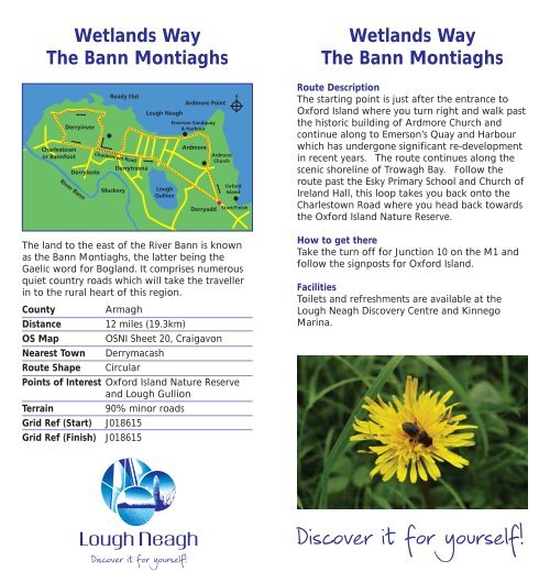
The land to the east of the River Bann is known<br />
as the Bann Montiaghs, the latter being the<br />
Gaelic word for Bogland. It comprises numerous<br />
quiet country roads which will take the traveller<br />
in to the rural heart of this region.<br />
<strong>Discover</strong> it for yourself!<br />
Ardmore Point<br />
Emerson Sandquay<br />
& Harbour<br />
Ardmore<br />
Derryadd<br />
Ardmore<br />
Church<br />
Oxford<br />
Island<br />
Start/Finish<br />
County Armagh<br />
Distance 12 miles (19.3km)<br />
OS Map OSNI Sheet 20, Craigavon<br />
Nearest Town Derrymacash<br />
Route Shape Circular<br />
Points of Interest Oxford Island Nature Reserve<br />
and <strong>Lough</strong> Gullion<br />
Terrain 90% minor roads<br />
Grid Ref (Start) J018615<br />
Grid Ref (Finish) J018615<br />
Wetlands Way<br />
The Bann Montiaghs<br />
Route Description<br />
The starting point is just after the entrance to<br />
Oxford Island where you turn right and walk past<br />
the historic building of Ardmore Church and<br />
continue along to Emerson’s Quay and Harbour<br />
which has undergone significant re-development<br />
in recent years. The route continues along the<br />
scenic shoreline of Trowagh Bay. Follow the<br />
route past the Esky Primary School and Church of<br />
Ireland Hall, this loop takes you back onto the<br />
Charlestown Road where you head back towards<br />
the Oxford Island Nature Reserve.<br />
How to get there<br />
Take the turn off for Junction 10 on the M1 and<br />
follow the signposts for Oxford Island.<br />
Facilities<br />
Toilets and refreshments are available at the<br />
<strong>Lough</strong> <strong>Neagh</strong> <strong>Discover</strong>y Centre and Kinnego<br />
Marina.<br />
<strong>Discover</strong> it for yourself!