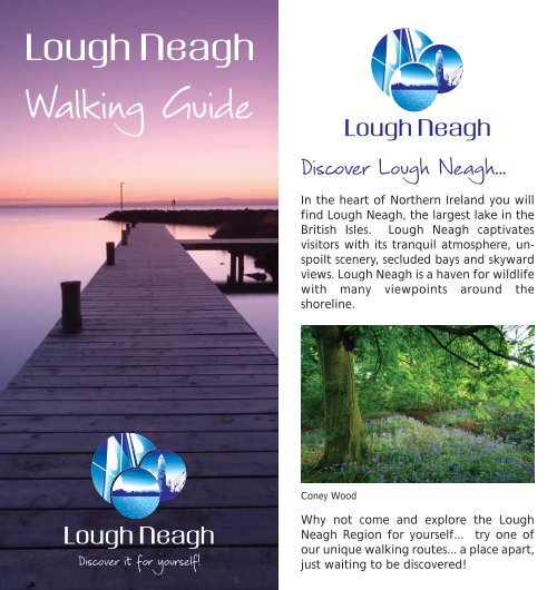
Walking Guide - Discover Lough Neagh
Walking Guide - Discover Lough Neagh
Walking Guide - Discover Lough Neagh

You also want an ePaper? Increase the reach of your titles
YUMPU automatically turns print PDFs into web optimized ePapers that Google loves.
<strong>Walking</strong> <strong>Guide</strong><br />
<strong>Discover</strong> it it for yourself!<br />
<strong>Discover</strong> <strong>Lough</strong> <strong>Neagh</strong>...<br />
In the heart of Northern Ireland you will<br />
find <strong>Lough</strong> <strong>Neagh</strong>, the largest lake in the<br />
British Isles. <strong>Lough</strong> <strong>Neagh</strong> captivates<br />
visitors with its tranquil atmosphere, unspoilt<br />
scenery, secluded bays and skyward<br />
views. <strong>Lough</strong> <strong>Neagh</strong> is a haven for wildlife<br />
with many viewpoints around the<br />
shoreline.<br />
Coney Wood<br />
Why not come and explore the <strong>Lough</strong><br />
<strong>Neagh</strong> Region for yourself... try one of<br />
our unique walking routes... a place apart,<br />
just waiting to be discovered!
Car<br />
Park<br />
Ballyronan Wood Walk<br />
<strong>Lough</strong> <strong>Neagh</strong><br />
Start/Finish<br />
Small<br />
Car Park<br />
Picnic Area<br />
& Camp Site<br />
Ballyronan wood is beautiful walk through a small<br />
5 acre wet woodland on the shores of <strong>Lough</strong><br />
<strong>Neagh</strong>. The area boasts a wealth of wildlife easily<br />
viewed from the woodland path, such as mute<br />
swan, whooper swan, great crested grebes and<br />
tufted duck.<br />
<strong>Discover</strong> it for yourself!<br />
Marina<br />
Centre<br />
Main<br />
Entrance<br />
Play<br />
Area<br />
Main<br />
Car Park<br />
County Londonderry<br />
Distance 1/2 mile (0.8km)<br />
OS Map OSNI Sheet 14, <strong>Lough</strong> <strong>Neagh</strong><br />
Nearest Town Ballyronan Village<br />
Route Shape Circular<br />
Points of Interest <strong>Lough</strong> <strong>Neagh</strong>, Ballyronan<br />
Marina, fishing & watersports<br />
Terrain Good flat woodland paths<br />
Grid Ref (Start) H994855<br />
Grid Ref (Finish) H994855<br />
Ballyronan Wood Walk<br />
Route Description<br />
Start from Ballyronan Marina Car park and<br />
head in the direction of the caravan park at the<br />
north of the site. Located at the entrance to the<br />
caravan park is the Ballyronan Wood Sign. Follow<br />
the yellow way markers on a circular path along<br />
the <strong>Lough</strong> Shore past the picnic areas. The return<br />
part of the walk is via a woodland trail that leads<br />
back around to the start/finish point at the<br />
caravan park.<br />
How to get there<br />
Located beside Ballyronan Marina, in the village<br />
of Ballyronan, on the shores of <strong>Lough</strong> <strong>Neagh</strong>.<br />
Approximately 12 miles from Cookstown.<br />
Facilities<br />
Facilities include a picnic site, caravan and<br />
camping, marina, childrens play area and toilets.<br />
<strong>Discover</strong> it for yourself!
Kinturk<br />
Heritage Centre<br />
Kinturk<br />
Gort Moss Walk<br />
Start/Finish<br />
Coyles<br />
Cottage<br />
Annaghmore<br />
<strong>Lough</strong> <strong>Neagh</strong><br />
Annaghmore Road<br />
Cluntoe<br />
This is a linear walk of 5 miles, along old moss<br />
roads and between leafy hedgerows close to the<br />
village of Ardboe. It passes the Kinturk Cultural<br />
Centre and Coyle's Cottage - a 300 year old<br />
fisherman’s cottage, made of mud, clay and<br />
wood, thatched with reeds.<br />
County Tyrone<br />
Distance 5 miles (8km)<br />
OS Map OSNI Sheet 14, <strong>Lough</strong> <strong>Neagh</strong><br />
Nearest Town Ardboe<br />
Route Shape Linear<br />
Points of Interest Kinturk Cultural Centre, Coyles<br />
Cottage, local wildlife<br />
Terrain Good sandy ramparts, muddy<br />
after rain<br />
Grid Ref (Start) H960800<br />
Grid Ref (Finish) H960800<br />
<strong>Discover</strong> it for yourself!<br />
Battery Road<br />
Abbey &<br />
Ardboe Cross<br />
Moortown<br />
Gort Moss Walk<br />
Route Description<br />
Starting at Kinturk Cultural Centre car park,<br />
walk along Kinturk Road 200m to Coyles<br />
Cottage. Enter Gort Moss via a concrete lane and<br />
turn left and travel south for 1 mile via Galiagh<br />
Rampart to Ardboe and Battery Road, retrace<br />
your steps (2 miles) and continue through Gort<br />
Moss, north to Sandy Rampart, Kinturk Road<br />
(3 miles). Follow the blue markers through farm<br />
lane fields to the cot bridge and cot lane to<br />
Ballylifford. Return to Coyles Cottage via Cot<br />
Lane, footbridge, Kinturk Road, Gortmoss and<br />
Curran Quay.<br />
How to get there<br />
Starting point opposite Coyle's Cottage, off the<br />
A73, 10 miles east of Cookstown.<br />
Facilities<br />
Public toilets are located at the Kinturk Cultural<br />
Centre.<br />
<strong>Discover</strong> it for yourself!
Rea’s Wood<br />
<strong>Lough</strong>shore<br />
Park Antrim<br />
Start/Finish<br />
Forum<br />
<strong>Lough</strong> <strong>Neagh</strong><br />
<strong>Lough</strong> Road<br />
Rea’s<br />
Wood<br />
Dublin Road<br />
Rea’s Wood extends along part of the shore of<br />
<strong>Lough</strong> <strong>Neagh</strong>. It is a great example of a wet<br />
woodland and has a rich diversity of wildlife to<br />
see, so please keep dogs on leads. The path forms<br />
part of the <strong>Lough</strong>shore Trail.<br />
County Antrim<br />
Distance 3 miles (5km)<br />
OS Map OSNI Sheet 14, <strong>Lough</strong> <strong>Neagh</strong><br />
Nearest Town Antrim<br />
Route Shape Circular<br />
Points of Interest Views of <strong>Lough</strong> <strong>Neagh</strong>,<br />
wildfowl and woodland birds<br />
Terrain Off road paths<br />
Grid Ref (Start) J139869<br />
Grid Ref (Finish) J139869<br />
<strong>Discover</strong> it for yourself!<br />
Reproduced by kind permission of Antrim Borough Council<br />
Rea’s Wood<br />
Route Description<br />
To get there; follow the signs to the <strong>Lough</strong> Shore<br />
Park off the Dublin Road in Antrim. On reaching<br />
the Park, turn left and continue to the car park<br />
that looks over <strong>Lough</strong> <strong>Neagh</strong>. Rea’s Wood lies to<br />
your left as you look out over the <strong>Lough</strong>. Follow<br />
the path into the Wood, ignoring all tracks off to<br />
the left and right. After 750m you reach the<br />
National Nature Reserve, and after a further<br />
kilometre before you reach the iron gate that<br />
delineates the southern limit of the Reserve, a<br />
path veers off to the left, leading to the Dublin<br />
Road. You can then either take this route turning<br />
left onto the Dublin Road, then left again into<br />
<strong>Lough</strong> Road and back to your starting point, or<br />
alternatively, simply retrace your steps back to<br />
the <strong>Lough</strong> Shore Park.<br />
How to get there<br />
From Antrim town, follow signs for <strong>Lough</strong> Shore<br />
Park.<br />
Facilities<br />
Toilets and refreshments are available in the<br />
<strong>Lough</strong> Shore Park.<br />
<strong>Discover</strong> it for yourself!
Cidercourt Road<br />
Crumlin Glen<br />
Crumlin Road<br />
Crumlin Glen<br />
Main Street<br />
Rising to the east on the slopes of Divis<br />
Mountain, the Crumlin River has carved a short<br />
but deep glen as it approaches the waters of<br />
<strong>Lough</strong> <strong>Neagh</strong>.<br />
Mill Road<br />
Start/Finish<br />
<strong>Discover</strong> it for yourself!<br />
Nutts Corner Road (A52)<br />
Crumlin River<br />
Railway Station<br />
County Antrim<br />
Distance 1.8 miles (3km)<br />
OS Map OSNI Sheet 14, <strong>Lough</strong> <strong>Neagh</strong><br />
Nearest Town Crumlin<br />
Route Shape Circular<br />
Points of Interest Cockle House, herons, waterfall<br />
and otters<br />
Terrain Off-road paths<br />
Grid Ref (Start) J154765<br />
Grid Ref (Finish) J154765<br />
Reproduced by kind permission of Antrim Borough Council<br />
Route Description<br />
To start this short walk, follow the path at the far<br />
(west) end of the car park over a footbridge and<br />
uphill where you then turn left. The walk passes<br />
through some beautiful woods, and then you<br />
soon turn left and follow the sign down to the<br />
Cockle House. Then, continue down to the<br />
riverbank and follow the path along its side.<br />
You soon reach a footbridge over the river to<br />
your left. Cross it and follow the path leading<br />
away from the river. This section of path leads<br />
to the Cidercourt Road. Turn right here, crossing<br />
Cidercourt Road almost immediately to join a<br />
public right of way leading to Main Street. Turn<br />
left onto Main Street and then left again onto<br />
Mill Road, and proceed back to the starting<br />
point. Please note: some steep sections.<br />
How to get there<br />
Crumlin Glen is signed off to the left on the<br />
Nutt's Corner Road in Crumlin, just before the<br />
railway bridge as you head out of the town.<br />
Facilities<br />
Toilets, Fishing stands.<br />
Crumlin Glen<br />
<strong>Discover</strong> it for yourself!
Moira<br />
The Broad Water<br />
Moira<br />
Railway<br />
Station<br />
Start/Finish<br />
Glenavy Road<br />
Soldierstown<br />
Broad Water<br />
The Broad Water is a towpath walk of some<br />
3 miles between Aghalee and Moira Railway<br />
Station and takes you along the route of the<br />
original Lagan Canal through Soldierstown. Keep<br />
an eye out for the large variety of breeding and<br />
wintering wildfowl.<br />
<strong>Discover</strong> it for yourself!<br />
Bank Rangers<br />
House<br />
Lock-Keepers<br />
House<br />
County Antrim<br />
Distance 3 miles (5km)<br />
OS Map OSNI sheet 20, Craigavon<br />
Nearest Town Moira Village<br />
Route Shape Linear<br />
Points of Interest Soldierstown Church &<br />
Graveyard<br />
Terrain Flat towpath<br />
Grid Ref (Start) J157618<br />
Grid Ref (Finish) J124649<br />
Aghalee<br />
Start/Finish<br />
Reproduced by kind permission of Antrim Borough Council<br />
The Broad Water<br />
Route Description<br />
The route begins in the Village of Aghalee and<br />
follows the line of the towpath of the old Lagan<br />
Canal to Moira Railway Station. A concealed<br />
entrance is located just off the Soldierstown<br />
Road. From here you can see the surviving lockkeeper’s<br />
house at No 18 lock. As you proceed<br />
along the towpath you will see a small property<br />
formerly owned by the Lagan Navigation<br />
Company.<br />
Since the canal was abandoned in 1954 the banks<br />
have become overgrown and an array of colour is<br />
provided by a variety of trees, shrubs and wild<br />
flowers. Just over half way along the route you<br />
will see the picturesque Soliderstown Church on<br />
your right. The final section of path takes us to<br />
Moira Railway Station, with the canal and<br />
towpath passing under the railway bridge which<br />
was built in 1833.<br />
How to get there<br />
Aghalee Village bridge, Station Road, Moira.<br />
Facilities<br />
Car parking available at Soldierstown.<br />
Refreshments available in Moira. Picnic area<br />
en-route.<br />
<strong>Discover</strong> it for yourself!
A6<br />
Randalstown Forest<br />
Moneynick Road<br />
Staffordstown Road<br />
M22<br />
Mount<br />
Shalgus Lane<br />
Randalstown<br />
Forest<br />
Start/Finish<br />
Randalstown<br />
River<br />
Main<br />
Randalstown Forest is a mixed conifer forest that<br />
contains an owl conservation centre, deer park,<br />
and several walking routes, with two small<br />
adjacent Nature Reserves at the forest edge on<br />
the shores of <strong>Lough</strong> <strong>Neagh</strong>.<br />
<strong>Discover</strong> it for yourself!<br />
M22<br />
Shane’s<br />
Castle<br />
A6<br />
<strong>Lough</strong> <strong>Neagh</strong><br />
County Antrim<br />
Distance 2.5 miles (4km)<br />
OS Map OSNI Sheet 14, <strong>Lough</strong> <strong>Neagh</strong><br />
Nearest Town Randalstown<br />
Route Shape Circular<br />
Points of Interest The rich birdlife of <strong>Lough</strong><br />
<strong>Neagh</strong> and wild deer<br />
Terrain Off-road paths<br />
Grid Ref (Start) J082886<br />
Grid Ref (Finish) J082886<br />
Reproduced by kind permission of Antrim Borough Council<br />
Randalstown Forest<br />
Route Description<br />
While there is the option of following several<br />
trails within the forest, this one follows the route<br />
indicated by the arrows on the map. From the<br />
parking area, follow the path into the forest, past<br />
the World of Owls and through the turnstile.<br />
Immediately after passing through the turnstile,<br />
turn right and follow the path around the<br />
western side of the forest. Continue following<br />
this path for approximately 1 mile until you reach<br />
a 'cross-roads' of tracks. The arrow indicates that<br />
you turn left but, for a small diversion, turn right<br />
at this point and follow the track through<br />
another turnstile to the Randalstown Forest and<br />
Farr's Bay Nature Reserves. Then, return to the<br />
'cross-roads' of tracks and continue following the<br />
red route. The track soon leads you back to the<br />
starting point where you turn right, pass through<br />
the turnstile and walk back to the car park.<br />
How to get there<br />
Follow New Street in Randalstown onto the<br />
Moneynick Road. Then turn left onto the<br />
Staffordstown Road, following the signs for<br />
Toome, before turning left again following the<br />
signs for Randalstown Forest.<br />
Facilities<br />
Car parking and picnic facilities.<br />
<strong>Discover</strong> it for yourself!
Six Mile Water<br />
(Incorporating The Mill Race Trail)<br />
<strong>Lough</strong><br />
<strong>Neagh</strong><br />
Start/Finish<br />
<strong>Lough</strong> Road<br />
Dublin Road<br />
Castle Way<br />
Belmont Road<br />
The Mill Race Trail is a site of importance in terms<br />
of its industrial heritage and wildlife value.<br />
Follow the way markers and information panels<br />
as they tell the story of the Six Mile Water. There<br />
is no entrance fee and leaflets on the Trail are<br />
available from Antrim Information Centre.<br />
<strong>Discover</strong> it for yourself!<br />
Greystone Road<br />
Belfast Road<br />
Oldstone Road<br />
County Antrim<br />
Distance 6 miles (10km)<br />
OS Map OSNI Sheet 14, <strong>Lough</strong> <strong>Neagh</strong><br />
Nearest Town Antrim Town<br />
Route Shape Linear<br />
Points of Interest Kingfishers, otters and the<br />
river’s industrial heritage<br />
Terrain Off road paths<br />
Grid Ref (Start) J149863<br />
Grid Ref (Finish) J166853<br />
Reproduced by kind permission of Antrim Borough Council<br />
Six Mile Water<br />
(Incorporating The Mill Race Trail)<br />
Route Description<br />
Starting from the <strong>Lough</strong> Shore Park at Antrim<br />
alongside the small café, follow the path along<br />
the banks of the river, away from the <strong>Lough</strong>.<br />
Keeping on the same bank of the river, follow<br />
the path as it leads to Antrim Forum. The path<br />
then leads under the Dublin Road and continues<br />
under a footbridge, before you climb some steps<br />
to Bridge Street. Turn left and then right onto<br />
High Street. Turn right onto Riverside and<br />
continue until you see where the road forks.<br />
Follow the gravelled left fork uphill onto the<br />
Mill Race Trail passing a green metal fingerpost.<br />
Then, follow the path under the Belmont Road<br />
and old railway viaduct before reaching the<br />
Salmon Leap Bridge. After the site of the former<br />
Boghill Mill and village, the walk passes by some<br />
beautiful woodland, past the remains of the<br />
Moylinny Bank Mill and Waterwheel, finishing at<br />
the Shakey Bridge. You can then exit the trail at<br />
the Oldstone Road or retrace your steps back to<br />
the <strong>Lough</strong> Shore Park.<br />
How to get there<br />
The trail can either be accessed from <strong>Lough</strong><br />
Shore Park or Antrim Town Centre. Alternatively,<br />
you can park your car at Kirby’s Lane (follow the<br />
brown tourist signs from Dublin Road or Oldstone<br />
Road into the car park), then walk in either<br />
direction.<br />
Facilities<br />
Information panels, picnic tables, and bike stands<br />
are available along the walk.<br />
<strong>Discover</strong> it for yourself!
To A6<br />
B18<br />
<strong>Lough</strong> <strong>Neagh</strong><br />
Toome Canal<br />
Creagh Road<br />
River<br />
Bann<br />
This is a short walk to the shores of <strong>Lough</strong> <strong>Neagh</strong>,<br />
along the banks of Toome Canal.<br />
B18<br />
Start/Finish<br />
Toome<br />
Start/Finish<br />
<strong>Discover</strong> it for yourself!<br />
Toome<br />
By-pass<br />
Moneynick RoadA6<br />
County Antrim<br />
Distance 1.25 miles (2km)<br />
OS Map OSNI Sheet 14, <strong>Lough</strong> <strong>Neagh</strong><br />
Nearest Town Toome<br />
Route Shape Circular<br />
Points of Interest Wide panoramic views over<br />
<strong>Lough</strong> <strong>Neagh</strong><br />
Terrain Off road paths<br />
Grid Ref (Start) H991452<br />
Grid Ref (Finish) H991452<br />
Reproduced by kind permission of Antrim Borough Council<br />
Toome Canal<br />
Route Description<br />
From the parking area, walk south towards the<br />
loughshore along the banks of Toome Canal.<br />
To your right are the remains of the old railway<br />
bridge over the Bann. As you continue towards<br />
the loughshore, you pass, again to your right,<br />
one of the Lower Bann sluice gates. The path<br />
soon reaches the shores of <strong>Lough</strong> <strong>Neagh</strong>. To<br />
finish this short walk, simply retrace your steps<br />
along the canal bank to the parking area or<br />
follow the loop to the right, back to the car park.<br />
How to get there<br />
As you approach Toome from Antrim, the road<br />
veers left just past the bus stop. Turn left<br />
immediately as this road swings right and park in<br />
the small area opposite the lock-keepers cottage.<br />
Facilities<br />
Information panels are available along the walk<br />
as well as picnic facilities public toilets in the<br />
village.<br />
<strong>Discover</strong> it for yourself!
Peatlands<br />
Park<br />
Wetlands Way<br />
Birches & Maghery<br />
River Blackwater<br />
Derryane<br />
Derrywarragh<br />
Island<br />
Peat Works<br />
Maghery<br />
Start/Finish<br />
Ennismore House<br />
Milltown Rectory<br />
Old Police Barracks<br />
Derrycaw<br />
<strong>Lough</strong> <strong>Neagh</strong><br />
Coney Island<br />
Disused Quarry<br />
Derrycarran<br />
The <strong>Lough</strong> <strong>Neagh</strong> Wetlands, up until the turn of<br />
the century, was regarded as the most extensive<br />
region of fenland in the islands of Britain and<br />
Ireland. The region is characterised by fen, cut<br />
over peat bog, woodland, small <strong>Lough</strong>s, and<br />
drumlins, and is dissected by two major rivers, the<br />
Bann and Blackwater.<br />
County Armagh<br />
Distance 12 miles (19km)<br />
OS Map OSNI Sheets 19, Armagh<br />
Nearest Town Maghery<br />
Route Shape Circular<br />
Points of Interest Coney Island and River Bann<br />
Terrain 90% minor roads<br />
Grid Ref (Start) H897630<br />
Grid Ref (Finish) H897630<br />
<strong>Discover</strong> it for yourself!<br />
Wetlands Way<br />
Birches & Maghery<br />
Route Description<br />
The starting point to the walk is Maghery<br />
Country Park. Exit the car park and turn left onto<br />
the road towards St Mary’s Church. Continue<br />
walking along the road and you will pass the<br />
19th Century Ennismore house with spectacular<br />
views of <strong>Lough</strong> <strong>Neagh</strong>. Continue along the<br />
route past the disused quarry which is a seminatural<br />
habitat where you can view a vast array<br />
of wildlife, as you walk further along the route<br />
you will pass the old police barracks, which has<br />
been restored into residential townhouses.<br />
Continue walking past the old Milltown Rectory,<br />
the Peatworks and then back into Maghery.<br />
How to get there<br />
Take the turn-off for Junction 12 on the M1 and<br />
follow signs to Maghery, Bus Station, Portadown<br />
Train Station, Lurgan and Portadown, Cycling,<br />
NCN Route 94.<br />
Facilities<br />
Carpark and picnic facilities are available in<br />
Maghery.<br />
<strong>Discover</strong> it for yourself!
Peatland Walk<br />
Derryhubbert<br />
Bog<br />
M1 Junction 13<br />
Start/Finish<br />
Entrance<br />
One of five walks through the bogland of the<br />
Peatlands Park.<br />
<strong>Discover</strong> it for yourself!<br />
Derryadd<br />
Lake<br />
County Tyrone<br />
Distance 5.5 miles (8.8km)<br />
OS Map OSNI Sheet 19, Armagh<br />
Nearest Town <strong>Lough</strong>gall<br />
Route Shape Circular<br />
Points of Interest Apple blossom, peatland and<br />
open lake<br />
Terrain Tarmac road, woodchip paths,<br />
boardwalks<br />
Grid Ref (Start) H897604<br />
Grid Ref (Finish) H897604<br />
Peatland Walk<br />
Route Description<br />
Follow the path sign marked with red arrows.<br />
There are another four walks of varying lengths.<br />
Peatlands Park was the first of its type in the<br />
British Isles and was specifically established to<br />
promote and facilitate peatland awareness and<br />
issues. Visitors can explore the 680 acre site on<br />
foot along its many paths and wooden walkways.<br />
In fact there are over 10 miles of paths leading<br />
the visitor through the many and varied habitats<br />
within the park. At 5.5 miles the Peatland Walk is<br />
one of the longest walks within the Park<br />
providing opportunities to see insectivorous<br />
plants, newts, hen harrier, dragonflies and<br />
Scottish wood ants (found nowhere else in<br />
Ireland). For further information visit<br />
www.ehsni.gov.uk/peatlands or email<br />
peatland@doeni.gov.uk.<br />
How to get there<br />
Take the turn-off for Junction 13 on the M1 and<br />
follow the signs for Peatlands Park.<br />
Facilities<br />
Reception area, car park, toilets, Education<br />
Centre and small gauge railway.<br />
<strong>Discover</strong> it for yourself!
Coalisland Canal Walk<br />
Coalisland<br />
Start/Finish<br />
Dam Lock<br />
Macks Lock<br />
Moor Lock<br />
Coalisland Canal<br />
River<br />
Torrent<br />
Channel Maghery<br />
High Bridge<br />
Start/Finish<br />
River Blackwater<br />
The Coalisland Canal Walk is steeped in history,<br />
being an important industrial heritage site as<br />
well as boasting diverse flora and fauna and is an<br />
important industrial heritage site. The Canal was<br />
opened in 1789 to bring coal from Coalisland to<br />
Dublin via the River Blackwater, <strong>Lough</strong> <strong>Neagh</strong><br />
and the Newry Canal. Coalisland acted as an<br />
inland port with lighters carrying grain for the<br />
mills and provisions for the surrounding towns.<br />
County Tyrone<br />
Distance 4.5 miles (7.2km)<br />
OS Map OSNI Sheet 19, Armagh<br />
Nearest Town Coalisland<br />
Route Shape Linear<br />
Points of Interest The Lockhouse<br />
Terrain Off road paths<br />
Grid Ref (Start) J844663<br />
Grid Ref (Finish) J887626<br />
<strong>Discover</strong> it for yourself!<br />
<strong>Lough</strong> <strong>Neagh</strong><br />
Derrywarragh<br />
Island<br />
Coalisland Canal Walk<br />
Route Description<br />
The walk starts at the Cornmill in Coalisland<br />
town centre. As you walk along the 4.5 mile<br />
canal stretch, you will see that it had seven locks<br />
each 15ft wide, including a staircase lock at<br />
Macks Bridge. Most of the structures still exist.<br />
Of the three lock houses on the Canal, just one<br />
remains intact (situated below the High Bridge).<br />
Between Macks Bridge and Moor Bridge the River<br />
Torrent is on one side of the towpath and the<br />
Canal on the other. The canal path ends at<br />
‘The Point’ where it meets the Blackwater River.<br />
How to get there<br />
Park your car at Cornmill car park in the centre of<br />
Coalisland. Exit the car park opposite Dorman’s<br />
chemist, turn left and walk 100 yards until you<br />
come to the dam lock.<br />
Facilities<br />
There are public toilets in the Cornmill car park.<br />
The walk also has seating and litter bins along<br />
the towpath.<br />
<strong>Discover</strong> it for yourself!
Craigavon Lakes<br />
Aghacommon<br />
Craigavon<br />
Lakes<br />
Start/Finish<br />
An extensive network of walking and cycling<br />
paths are set within the Parkland around the<br />
Craigavon Lakes and are suitable for disabled<br />
users and families and incorporate the National<br />
Cycle Network Route 9. The route around the<br />
two lakes is 3 miles.<br />
<strong>Discover</strong> it for yourself!<br />
Silverwood<br />
Brownlow<br />
Gilpinstown<br />
County Armagh<br />
Distance 3 miles (5km)<br />
OS Map OSNI Sheet 20, Craigavon<br />
Nearest Town Craigavon<br />
Route Shape Circular<br />
Points of Interest Craigavon Watersports Centre,<br />
Tannaghmore Gardens<br />
Terrain Varied surfaces & shared paths<br />
Grid Ref (Start) J048569<br />
Grid Ref (Finish) J048569<br />
Craigavon Lakes<br />
Route Description<br />
From the Craigavon Watersports Centre car park,<br />
start walking on the wide tarmac path beside the<br />
lake and walk in either a clockwise or anticlockwise<br />
direction, keeping the lake to one side.<br />
For the first half of the walk, follow the signs for<br />
Tannaghmore Gardens. Once you have reached<br />
the gardens, follow the signs for Craigavon Water<br />
Sports Centre to return to the car park. During<br />
the walk, you will come to two bridges. You must<br />
pass under these in order to complete the circuit<br />
of both lakes. It will take approximately 1hr to<br />
complete the walk.<br />
How to get there<br />
A recommended starting point for the walk is<br />
Craigavon Watersports Centre, where a car park,<br />
toilets, refreshments and further information are<br />
available.<br />
Facilities<br />
Toilets available at Watersports Centre and<br />
Tannaghmore Gardens. Refreshments also<br />
available at Watersports Centre.<br />
<strong>Discover</strong> it for yourself!
Wetlands Way<br />
The Bann Montiaghs<br />
Charlestown<br />
or Bannfoot<br />
Derryinver<br />
River Bann<br />
Derryloste<br />
Ready Flat<br />
Charlestown Road<br />
Muckery<br />
Derrytrasna<br />
<strong>Lough</strong> <strong>Neagh</strong><br />
<strong>Lough</strong><br />
Gullion<br />
The land to the east of the River Bann is known<br />
as the Bann Montiaghs, the latter being the<br />
Gaelic word for Bogland. It comprises numerous<br />
quiet country roads which will take the traveller<br />
in to the rural heart of this region.<br />
<strong>Discover</strong> it for yourself!<br />
Ardmore Point<br />
Emerson Sandquay<br />
& Harbour<br />
Ardmore<br />
Derryadd<br />
Ardmore<br />
Church<br />
Oxford<br />
Island<br />
Start/Finish<br />
County Armagh<br />
Distance 12 miles (19.3km)<br />
OS Map OSNI Sheet 20, Craigavon<br />
Nearest Town Derrymacash<br />
Route Shape Circular<br />
Points of Interest Oxford Island Nature Reserve<br />
and <strong>Lough</strong> Gullion<br />
Terrain 90% minor roads<br />
Grid Ref (Start) J018615<br />
Grid Ref (Finish) J018615<br />
Wetlands Way<br />
The Bann Montiaghs<br />
Route Description<br />
The starting point is just after the entrance to<br />
Oxford Island where you turn right and walk past<br />
the historic building of Ardmore Church and<br />
continue along to Emerson’s Quay and Harbour<br />
which has undergone significant re-development<br />
in recent years. The route continues along the<br />
scenic shoreline of Trowagh Bay. Follow the<br />
route past the Esky Primary School and Church of<br />
Ireland Hall, this loop takes you back onto the<br />
Charlestown Road where you head back towards<br />
the Oxford Island Nature Reserve.<br />
How to get there<br />
Take the turn off for Junction 10 on the M1 and<br />
follow the signposts for Oxford Island.<br />
Facilities<br />
Toilets and refreshments are available at the<br />
<strong>Lough</strong> <strong>Neagh</strong> <strong>Discover</strong>y Centre and Kinnego<br />
Marina.<br />
<strong>Discover</strong> it for yourself!
Oxford Island<br />
<strong>Lough</strong><br />
<strong>Neagh</strong><br />
Closet<br />
Hide<br />
Croaghan<br />
Hide<br />
This trail takes in the Oxford Island National<br />
Nature Reserve which is a haven for wildlife.<br />
Visitors can explore a range of habitats from<br />
woodlands to reedbeds. The walk also takes in<br />
a variety of bird hides which are placed along<br />
the trail.<br />
<strong>Discover</strong> it for yourself!<br />
Start/Finish<br />
<strong>Discover</strong>y<br />
Hide<br />
Kinnego<br />
Hide<br />
County Armagh<br />
Distance 1 miles (1.6km)<br />
OS Map OSNI Sheet 20, Craigavon<br />
Nearest Town Lurgan, Craigavon, Portadown<br />
Route Shape Circular<br />
Points of Interest <strong>Lough</strong> <strong>Neagh</strong> <strong>Discover</strong>y Centre<br />
and Kinnego Marina<br />
Terrain 70% Traffic Free Paths<br />
Grid Ref (Start) J048620<br />
Grid Ref (Finish) J048620<br />
Oxford Island<br />
Route Description<br />
Starting at the <strong>Discover</strong>y Centre the route<br />
extends down the west shore following the green<br />
arrows. There is a variety of habitats as well as<br />
flora and fauna to be seen along the <strong>Lough</strong><br />
shoreline. Signposted along the trail are 4 bird<br />
hides where you can stop off for a spot of birdwatching.<br />
In the spring look out for the Great<br />
Crested Grebe with their courting display and in<br />
the summer stop and close your eyes and listen<br />
to the melodious song of the Reed Warbler.<br />
You will finish your walk at the <strong>Discover</strong>y Centre.<br />
How to get there<br />
By car - Take turn-off for Junction 10 on the M1<br />
and follow signs to Oxford Island.<br />
Bus and Train Station: Lurgan<br />
Cycling: NCN Route 9 + 94<br />
Facilities<br />
Toilets and refreshments are available in the<br />
<strong>Lough</strong> <strong>Neagh</strong> <strong>Discover</strong>y Centre and Kinnego<br />
Marina. Accommodation is available at Kinnego<br />
Caravan Park.<br />
<strong>Discover</strong> it for yourself!
Additional information on walking routes are available<br />
from each Tourist Information Centre listed below.<br />
Tourist Information Centres<br />
Belfast (& Northern Ireland) Welcome Centre<br />
47 Donegall Place<br />
Tel: 028 9024 6609<br />
Email : info@belfastvisitor.com<br />
Antrim Tourist Information Centre<br />
16 High Street, Antrim<br />
Tel: 028 9442 8331 Email: info@antrim.gov.uk<br />
Crumlin Tourist Information Centre<br />
Belfast International Airport<br />
Tel: 028 9448 4677 Email: info@belfastvisitor.com<br />
Craigavon Tourist Information<br />
<strong>Lough</strong> <strong>Neagh</strong> <strong>Discover</strong>y Centre, Oxford Island, Craigavon<br />
Tel: 028 3832 2205 Web: www.craigavon.gov.uk<br />
Lisburn Tourist Information Centre<br />
15 Square Street, Lisburn<br />
Tel: 028 9266 0038 Email: tic.lisburn@lisburn.gov.uk<br />
Magherafelt Tourist Information Centre<br />
The Bridewell Centre, 6 Church Street, Magherafelt<br />
Tel: 028 7963 1510 Email: thebridewell@magherafelt.gov.uk<br />
Cookstown Tourist Information Centre<br />
The Burnavon, Burn Road, Cookstown<br />
Tel: 028 8676 9949 Email: tic@cookstown.gov.uk<br />
Ballymena Tourist Information Centre<br />
76 Church St, Ballymena<br />
Tel: 028 2563 8494<br />
Email: tourist.information@ballymena.gov.uk<br />
Killymaddy Tourist Information Centre<br />
190 Ballygawley Road Dungannon<br />
Tel: 028 8776 7259<br />
Email: killymaddy.reception@dungannon.gov.uk<br />
<strong>Discover</strong> it for yourself!<br />
Useful Contacts<br />
<strong>Lough</strong> <strong>Neagh</strong> Partnership<br />
Tel: 028 7941 7941 www.discoverloughneagh.com<br />
Email: info@loughneaghpartnership.com<br />
Northern Ireland Tourist Board<br />
Tel: 028 9023 1221<br />
Email: info@nitb.com<br />
Sperrins Tourism Limited<br />
Tel: 028 867 47700<br />
Email: info@sperrinstourism.com<br />
Countryside & Activities Network<br />
Tel: 02890 303930<br />
Web: www.countrysiderecreation.com<br />
<strong>Lough</strong>shore Trail<br />
Tel: 028 7941 7941<br />
Email : info@loughneaghpartnership.com<br />
Translink Bus & Rail Information<br />
Tel: 028 90 66 66 30<br />
Web: www.translink.co.uk<br />
Ordnance Survey Northern Ireland<br />
Tel: 028 90 255755<br />
Email: osni@osni.gov.uk<br />
Northern Ireland Self Catering Holiday Association<br />
Tel: 028 90436632<br />
Email : info@nischa.com<br />
Hostelling International Northern Ireland<br />
Tel: 028 9032 4733<br />
Email: info@hini.org.uk<br />
<strong>Discover</strong> it for yourself!<br />
<strong>Discover</strong> it for yourself! <strong>Discover</strong> it for yourself!
Key To Maps<br />
Key to Maps<br />
Built-up Area<br />
Parking<br />
River<br />
Road<br />
M1<br />
Tarmac/Path<br />
Jetty<br />
Building<br />
Main Path<br />
Railway<br />
Trees<br />
Wood/Trees<br />
Start/Finish<br />
<strong>Discover</strong> it for yourself!<br />
<strong>Discover</strong> it for yourself!<br />
<strong>Discover</strong> it for yourself!<br />
For further information<br />
on <strong>Lough</strong> <strong>Neagh</strong> visit:<br />
www.discoverloughneagh.com<br />
This project is supported by<br />
the <strong>Lough</strong> <strong>Neagh</strong> Partnership and is partly financed<br />
by the European Commission through the Programme<br />
for Building Sustainable Prosperity.<br />
<strong>Lough</strong> <strong>Neagh</strong> Partnership, The Marina Centre, Unit 3,<br />
135a Shore Road, Ballyronan, Magherafelt BT45 6JA<br />
T: 028 7941 7941 F: 028 7941 7979<br />
E: info@loughneaghpartnership.com<br />
www.loughneaghpartnership.com<br />
Disclaimer: The information contained in the guide is given in good faith on the<br />
basis of information obtained. <strong>Lough</strong> <strong>Neagh</strong> Partnership cannot guarantee the<br />
accuracy of the information in the guide and accept no responsibility for the error<br />
or misrepresentation. All liability for loss, disappointment, negligence or other<br />
damage caused by the reliance on the information contained in this guide, or in the<br />
event of bankruptcy or liquidation of any company, individual or firm mentioned, or<br />
in the event of any company, individual or firm ceasing to trade, is hereby excluded.