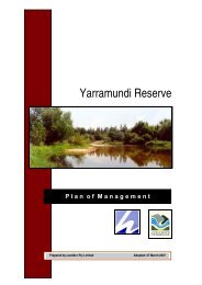
Yarramundi Reserve Brochure
Yarramundi Reserve Brochure
Yarramundi Reserve Brochure

You also want an ePaper? Increase the reach of your titles
YUMPU automatically turns print PDFs into web optimized ePapers that Google loves.
With its 78-hectare riparian setting, <strong>Yarramundi</strong> <strong>Reserve</strong> is one<br />
of the Hawkesbury’s most popular parks, offering opportunities<br />
for a range of nature-based activities.<br />
Location and access<br />
<strong>Yarramundi</strong> <strong>Reserve</strong> is located at the confluence of the Grose<br />
and Hawkesbury-Nepean Rivers. Access is off Springwood Road,<br />
<strong>Yarramundi</strong>, with a main entrance and car park on the northern<br />
side of Springwood Road and a minor entrance on the southern<br />
side, adjacent to the <strong>Yarramundi</strong> Bridge.<br />
Pedestrian access to the northern most section of the reserve can<br />
be gained from the adjacent Navua <strong>Reserve</strong>, off Ashtons Road,<br />
Grose Wold. Wheelchair and pram access are available from the<br />
northern car park.<br />
Flora and Fauna<br />
Although the vegetation of <strong>Yarramundi</strong> <strong>Reserve</strong> is highly degraded,<br />
it plays an important role in supporting a variety of native animals<br />
and providing a vegetated linkage to other areas of bushland.<br />
It is believed that the vegetation within the reserve once<br />
consisted of River Oak Forest and the now endangered River-flat<br />
Eucalypt Forest. However, what exists within the reserve today<br />
is mostly planted, with some remnant trees and natural regrowth<br />
occurring. As many as 68 native plant species have established<br />
themselves within the reserve.<br />
Many of the birds and animals using the reserve assist with the<br />
pollination and dispersal of native plants within the reserve.<br />
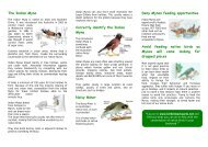
A Grey-headed Flying Fox colony will sometimes come to<br />
visit the reserve and these are well know for their wide ranging<br />
foraging habits. They feed on the fruit, nectar and blossom of<br />
eucalypts and rainforest plants. Due to habitat clearing, they<br />
are listed as a vulnerable species under the Threatened Species<br />
Conservation Act.<br />
Birdwatchers can view a variety of woodland and wetland birds<br />
within the reserve. Over 93 different species have been recorded,<br />
including Ducks, Herons, Eagles, Doves, Parrots, Wrens,<br />
Honeyeaters and Finches.<br />
The reserve is also very popular for fishing, with at least 14<br />
species of fish known to live in the area, though not all of them<br />
are suitable for fishing. You may find Bass, Catfish, Eels, Mullet<br />
and Gudgeons in these waters, as well as exotic fish such as Carp<br />
and Goldfish also occur here.<br />
Due to the abundance of native wildlife within the reserve, the<br />
southern portion of the reserve, south of Springwood Road, is<br />
managed as a conservation zone and Wildlife Refuge.<br />
Solitude, tranquillity, diversity—a natural<br />
setting for informal family recreation<br />
History of the <strong>Reserve</strong><br />
Aboriginal people, particularly the Buruberongal clan of the<br />
Darug had a strong association with the area around <strong>Yarramundi</strong><br />
<strong>Reserve</strong>. This area was an important source of stone for tool<br />
making and the diverse landscape provided water, fish, animals<br />
and plants for food, fibres, tools, canoe making and medicine.<br />
After European settlement, the land now comprising the reserve<br />
was used for grazing and crops. In 1868, this area was notified<br />
as a crown reserve and a lease for the removal of ballast and<br />
gravel from the island was granted. During the early 1900’s,<br />
sand was mined to meet the demand for high quality river sand<br />
for public buildings, including the Sydney Harbour Bridge.<br />
Sand and gravel continued to be extracted until 1989.<br />
The extraction activities have dramatically altered the landform<br />
of the reserve. The large open “lagoon” at the southern end of the<br />
reserve is a flooded former excavation pit. It covers an area of approximately<br />
30 hectares and originally had a depth of 3.6 metres.<br />
In 2002, Hawkesbury City Council became the Trust Manager<br />
of <strong>Yarramundi</strong> <strong>Reserve</strong> when the reserve was gazetted for public<br />
recreation and environmental protection. After some initial<br />
landscaping and restoration works, the reserve was officially<br />
opened to the public in 2007.