

Texas Coastal Dunes - Texas Coastal Erosion Data Network
Texas Coastal Dunes - Texas Coastal Erosion Data Network
Texas Coastal Dunes - Texas Coastal Erosion Data Network

Create successful ePaper yourself
Turn your PDF publications into a flip-book with our unique Google optimized e-Paper software.
<strong>Texas</strong> <strong>Coastal</strong> <strong>Dunes</strong><br />
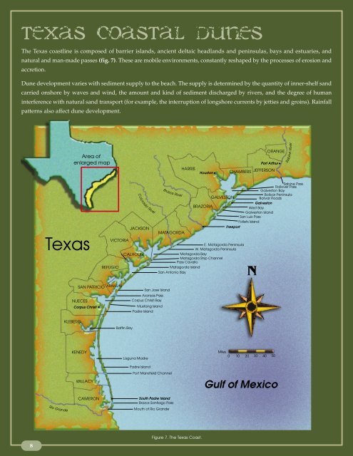
The <strong>Texas</strong> coastline is composed of barrier islands, ancient deltaic headlands and peninsulas, bays and estuaries, and<br />
natural and man-made passes (fig. 7). These are mobile environments, constantly reshaped by the processes of erosion and<br />
accretion.<br />
Dune development varies with sediment supply to the beach. The supply is determined by the quantity of inner-shelf sand<br />
carried onshore by waves and wind, the amount and kind of sediment discharged by rivers, and the degree of human<br />
interference with natural sand transport (for example, the interruption of longshore currents by jetties and groins). Rainfall<br />
patterns also affect dune development.<br />
8<br />
<strong>Texas</strong><br />
Rio Grande<br />
Area of<br />
enlarged map<br />
VICTORIA<br />
REFUGIO<br />
SAN PATRICIO ARANSAS<br />
NUECES<br />
KLEBERG<br />
Corpus Christi<br />
KENEDY<br />
WILLACY<br />
CAMERON<br />
JACKSON<br />
CALHOUN<br />
Baffin Bay<br />
Colorado River<br />
Brazos River<br />
MATAGORDA<br />
San Jose Island<br />
Aransas Pass<br />
Corpus Christi Bay<br />
Mustang Island<br />
Padre Island<br />
Laguna Madre<br />
Padre Island<br />
Port Mansfield Channel<br />
South Padre Island<br />
Brazos Santiago Pass<br />
Mouth of Rio Grande<br />
HARRIS<br />
Houston<br />
BRAZORIA<br />
GALVESTON<br />
CHAMBERS JEFFERSON<br />
Freeport<br />
E. Matagorda Peninsula<br />
W. Matagorda Peninsula<br />
Matagorda Bay<br />
Matagorda Ship Channel<br />
Pass Cavallo<br />
Matagorda Island<br />
San Antonio Bay<br />
Figure 7. The <strong>Texas</strong> Coast.<br />
N<br />
Miles<br />
0 10 20 30 40 50<br />
ORANGE<br />
Sabine<br />
Port Arthur River<br />
Sabine Pass<br />
Rollover Pass<br />
Galveston Bay<br />
Bolivar Peninsula<br />
Bolivar Roads<br />
Galveston<br />
West Bay<br />
Galveston Island<br />
San Luis Pass<br />
Follets Island<br />
Gulf of Mexico
On the upper coast, in Jefferson and Chambers counties, beach and dune development is<br />
limited. The Sabine River carries silt rather than sand to the coast. The shoreline is<br />
characterized by low-lying marshes and tidal flats with intermittent thin, linear sand<br />
ridges (chenier plain). <strong>Dunes</strong> are also scarce along the Brazos-Colorado river headland—<br />
the southern portion of the Brazoria County shoreline. Here, too, little dune-building sand<br />
is available to the longshore current.<br />
Few naturally occurring dunes can be found on Galveston Island and portions of Follets<br />
Island because many of the foredunes were wiped out during Hurricane Alicia in 1983 and<br />
shoreline development and high erosion rates have inhibited dune recovery (fig. 8).<br />
Vegetated and relatively stable dunes occur on Mustang Island and North Padre Island. On<br />
Matagorda and San Jose islands, where there is limited shorefront development, there is a<br />
continuous, well-defined foredune ridge averaging 15 to 20 feet above sea level. The most<br />
highly developed dune formations are found in Nueces and northern Kleberg counties,<br />
where there is a foredune ridge consisting of several rows of dunes that average 20 to 25<br />
feet in height. Some dunes reach an elevation of 40 feet. Sandflats and areas of low coppice<br />
mounds are also characteristic of this region (fig 9).<br />
As rainfall decreases southward along the <strong>Texas</strong> Coast, dunes have less of the vegetative<br />
cover necessary for stabilization. Migrating dunes—bare of vegetation and highly<br />
susceptible to wind erosion—are common in the arid environment of the lower coast<br />
(fig. 10). <strong>Dunes</strong> of this type occur on Padre Island. In Kenedy, Willacy, and Cameron<br />
counties, the foredune ridge is poorly developed and breached by numerous<br />
washovers and blowouts.<br />
Dune Construction,<br />
Improvement, and Repair<br />
Several methods may be used to increase the height and stability of existing dunes, repair<br />
damaged dunes, encourage sand accumulation closer to the beach, or establish dunes where<br />
a low sand supply has inhibited dune formation or where dunes have been destroyed.<br />
Where fresh sand deposits around obstructions such as grass clumps show conditions<br />
conducive to natural dune formation, plantings of native vegetation or structural barriers<br />
can be used to start and accelerate sand accumulation. Plantings of native vegetation<br />
should be the primary method for dune construction, improvement, and repair. Plant<br />
vegetation on grade in the backshore and close to the line of vegetation. Structures such as<br />
slatted wood or plastic sand fencing can help trap sand and stabilize dunes, but they<br />
should be used as a last resort and removed when vegetation is established.<br />
In areas where the local sand supply is insufficient for these two sand-trapping methods to<br />
be effective, dunes can be artificially constructed with imported sand. All dune improvement<br />
project sites must be vegetated to maintain stability.<br />
9
10<br />
Figure 8. Oblique aerial photo of natural dune formations adjacent to shorefront development<br />
on Follets Island. Natural dunes exist where there is ample sediment<br />
and where the shoreline is allowed to migrate.<br />
Figure 9. Natural dune formations on Padre Island in Kleberg County.<br />
Figure 10. Migrating dune at Padre Island National Seashore.
“Beach Access and<br />
Dune Protection Laws”<br />
Refer to page 23<br />
“Where to Get Help”<br />
Refer to page 25<br />
“Beach Access and<br />
Dune Protection Laws”<br />
Refer to page 23<br />
Figure 11. Recently planted dune vegetation.<br />
Before any of the following procedures for dune construction or shoreline stabilization are<br />
employed, check with the local building official or the <strong>Texas</strong> General Land Office to avoid<br />
violation of state laws (see “Beach Access and Dune Protection Laws”). Agents from the<br />
U.S. Department of Agriculture Natural Resources Conservation Service can provide<br />
technical assistance for dune restoration projects (see “Where to Get Help”).<br />
Use of Vegetation<br />
Three species of grass are appropriate for dune vegetation projects on the <strong>Texas</strong> coast: bitter<br />
panicum (Panicum amarum), sea oats (Uniola paniculata), and marshhay cordgrass (Spartina<br />
patens). Dune plants are not always available commercially in <strong>Texas</strong>. They usually are<br />
transplanted from natural stands.<br />
Transplants from the vicinity of the project are more likely to survive than imported ones.<br />
If suitable stands cannot be found on the property where the vegetation project will be<br />
undertaken, it may be possible to obtain plants from neighboring property by agreement<br />
with property owners. A permit from the county commissioners court or from a city may<br />
be required if the harvesting or planting site is seaward of a dune protection line (see<br />
“Beach Access and Dune Protection Laws”).<br />
The best time of year to transplant vegetation south of Corpus Christi is January or<br />
February. The optimum time for transplanting north of Corpus Christi is February, March,<br />
or April.<br />
Take plants only from dense stands in areas that are not subject to erosion. Plants should<br />
not be taken from coppice mounds or from foredunes that are sparsely vegetated. Be careful<br />
not to trample plants. Remove individual plants in a scattered pattern at intervals of<br />
no less than two feet. Dig them out with a “sharpshooter”shovel. Pulling plants damages<br />
the small hair roots needed for re-establishment. Obtain a<br />
good root structure to ensure plant survival.<br />
Small areas and steep slopes at the project site are best<br />
vegetated by hand. Set single plants into individual holes<br />
made with a shovel or dibble and pack each planting firmly.<br />
Large, flat areas can be more economically planted with<br />
tractor-drawn transplanters such as one- or two-row<br />
tobacco transplanters with their shoes extended to make<br />
holes eight to 10 inches deep. One thousand plants should<br />
stabilize a 50- by 100-foot strip within a year (fig. 11).<br />
Immediate watering of transplants is not imperative, but<br />
success is increased if transplanting is done after a rain or if<br />
the dune is watered before transplanting. Apply mulch<br />
either before or after planting to minimize wind erosion,<br />
moderate soil temperature, and help retain moisture. Hay,<br />
burlap, and commercial screen or mesh made of natural<br />
11
12<br />
Figure 12. Sign for dune restoration project.<br />
Figure 13. Bitter panicum (Panicum amarum).<br />
fiber may be used for this purpose. Hay is the most economical mulch. Use at least<br />
3,000 pounds of hay per acre. Pack the hay into the soil to prevent it from blowing<br />
away. In areas where high winds are common, burlap or screen anchored with stakes<br />
is recommended instead of hay. All of these materials are biodegradable and will<br />
eventually break down over time.<br />
Transplanted vegetation needs little maintenance. While watering new plants is helpful,<br />
continued watering is necessary only in drought conditions.<br />
Fertilization may be used during the first year after<br />
transplanting but is usually unnecessary thereafter. An<br />
approved soils testing laboratory can provide fertilizer<br />
recommendations for a particular location. In general,<br />
three or four applications of 12-6-6 fertilizer, 90 to 100<br />
pounds per acre, are recommended beginning in April or<br />
May. Mowing dune grasses destroys their ability to trap<br />
sand and may kill the plants. Planted areas should be<br />
protected from vehicles, pedestrians, and grazing animals<br />
with temporary fencing. Signs can be placed at the site to<br />
explain the purpose and importance of the project (fig. 12).<br />
A transplant survival rate of 50 to 80 percent can be expected.<br />
If the survival rate is less than 10 percent, the area should be<br />
replanted. The vegetation should be fairly dense within one<br />
or two years. Any bare areas that remain after that time can be<br />
replanted with vegetation from the well-established sites.<br />
Bitter Panicum<br />
Bitter panicum has proved to be the best species for dune<br />
stabilization on the <strong>Texas</strong> coast. This native beach plant has<br />
a higher salt tolerance than many other coastal species and<br />
is a hardy grower. Its leaves are smooth, bluish-green, 1/4<br />
to 1/2 inch wide, and four to 12 inches long (fig. 13). New<br />
plants are generated from tillers, shoots that grow from<br />
nodes on the roots. The seeds of bitter panicum are sterile<br />
and will not propagate new plants.<br />
Bitter panicum plants taken for vegetation projects should<br />
be two to three feet tall. Cut off the tops of harvested plants<br />
about one foot from the roots to reduce water loss (fig. 14).<br />
The plants can be stored for up to four weeks if the roots are<br />
wrapped in wet cloth or paper towels or immersed in<br />
fresh water.<br />
The best period for planting bitter panicum is early winter<br />
to early summer, but survival is dependent mainly on
adequate moisture. The plants can be placed in the ground<br />
either upright or horizontally. In areas of rapidly shifting<br />
sand, upright planting will prevent the plants from being<br />
buried. Generally, the plants should be planted six inches<br />
deep on two-foot centers, but closer placement is recommended<br />
on the tops of dunes and on steep slopes. The transplant site<br />
must be protected from grazing animals, as bitter panicum<br />
is palatable to them.<br />
Sea Oats<br />
Sea oats, also native to the <strong>Texas</strong> coast, may be interspersed<br />
among plantings of bitter panicum. This grass has pale<br />
green, hardy leaves that die back each winter and stiff, seedtopped<br />
stems that grow to three feet or more in length (fig.<br />
15). Sea oats are less tolerant of salt spray than bitter panicum<br />
but grow rapidly enough to avoid being smothered in<br />
rapidly shifting sand. Interplanting sea oats and bitter<br />
panicum will reduce the risk of disease or pest infestation.<br />
Harvest only healthy, vigorous plants for transplanting. The<br />
younger sea oats have a greater success rate than the older,<br />
longer-rooted plants. Do not take a plant that has a seed<br />
head. Transplant the plants as soon as possible after they<br />
have been harvested. The plants will generally remain alive<br />
for up to four days if the roots are wrapped in wet cloth<br />
or paper towels or immersed in fresh water. As with bitter<br />
panicum, the tops of the plants should be cut to within one<br />
foot of the roots to reduce water loss.<br />
The best time for planting sea oats is from October through<br />
April. Place plants at least eight to 10 inches deep on 18-inch<br />
centers in the main area of the dune, with graduated plantings extending to four feet apart<br />
at the edges.<br />
It is best to mix a sea oat planting with bitter panicum at a ratio of one to one. Sea oats<br />
usually take two growing seasons to fully stabilize a dune, while bitter panicum, which<br />
grows more rapidly, can become established in one year.<br />
Marshhay Cordgrass<br />
Marshhay cordgrass is a small, wiry perennial which spreads by rhizomes (fig. 16). This<br />
grass does well on the landward side of dunes. If planted on the beach side, the grass is easily<br />
buried and destroyed by shifting sands. The most appropriate use for marshhay cordgrass<br />
is to repair the more stable portions of existing and new dunes.<br />
June through November is the best time to plant marshhay cordgrass. Place the plants six<br />
Figure 14. Harvesting and cutting bitter panicum.<br />
Figure 15. Sea oats (Uniola paniculata).<br />
13
14<br />
to 10 inches deep and 12 to 36 inches apart to keep the base<br />
of each plant moist. Mixing marshhay cordgrass with<br />
plantings of bitter panicum produces best results.<br />
Other Plants<br />
Sea oats and bitter panicum, which commonly grow on the<br />
seaward face of foredunes, are highly erosion-resistant and<br />
easily established. However, other species of herbaceous<br />
plants also capture windblown sand and stabilize dunes.<br />
Beach morning glory and seagrape vines can form a dense<br />
cover on the seaward side of dunes within a few growing<br />
seasons. Low-growing plants and shrubs found on the<br />
back side of the dunes include seacoast bluestem,<br />
cucumberleaf sunflower, rose ring gallardia, partridge pea,<br />
prickly pear, and lantana. Many of these are flowering<br />
plants, an attractive alternative to dune grasses though less effective as dune stabilizers.<br />
Figure 16. Marshhay cordgrass (Spartina patens).<br />
Photo courtesy of Frederique Perret.<br />
“Where to Get Help”<br />
Refer to page 25<br />
Figure 17. Sand fencing used to trap sand.<br />
Some of these species are available commercially in <strong>Texas</strong>. Contact the <strong>Texas</strong> General Land<br />
Office, the Kika de la Garza <strong>Texas</strong> Plant Materials Center, or the Lady Bird Johnson<br />
National Wildflower Center for a list of nurseries or if you have questions regarding the<br />
use of a specific plant species for a dune restoration project (see “Where to Get Help”).<br />
Use of Structures<br />
The planting of native vegetation to trap sand is always preferable to the use of man-made<br />
structures. For reasons of aesthetics, safety, and possible interruption of public access,<br />
dune-building structures other than trees or brush must be<br />
removed as soon as they have served their purpose.<br />
Standard slatted wood sand fencing is ideal for dune-building<br />
structures because it is inexpensive, readily available, easy<br />
to handle, and can be erected quickly.<br />
Plastic fencing has the advantage of being strong,<br />
nondegradable, and reusable. Because plastic is nonflammable,<br />
it will not be taken for campfire fuel. Plastic<br />
fencing, however, is about three times as expensive as<br />
wooden sand fencing (fig. 17). Successful experiments in<br />
stabilizing dunes and dune vegetation using porous jute<br />
netting as sand fencing and as protective ground cover<br />
have been conducted at the Padre Island National Seashore.<br />
Trees (particularly discarded Christmas trees), brush, and<br />
seaweed can be also effective for trapping sand. Make sure<br />
that the piles are not too dense and that air can flow within
them. Inorganic debris such as automobile bodies, concrete, wire, or tires must not be used<br />
for dune building. These materials are not biodegradable and are safety hazards.<br />
Aheight of four feet, measured from the ground surface after installation, is recommended<br />
for dune-building structures. In areas where sand conditions are poor for dune building, a<br />
height of two feet is appropriate.<br />
The fencing can be supported with wooden posts or metal poles at 10-foot intervals.<br />
Wooden posts should be black locust, red cedar, white cedar, or other wood of equal life<br />
and strength. Treated pine may be used as well.<br />
The minimum practical length for posts is 6.5 feet; a length of 7 to 8 feet is optimum.<br />
Wooden posts should be no larger than three inches in diameter (fig. 18).<br />
Secure the fencing material by fastening it to each post with four ties of galvanized wire (no<br />
smaller than 12 gauge), and weave the material between the posts so that every other post<br />
has fencing on the seaward side.<br />
Trees, brush, and seaweed can be held in place with smooth wire strung between support<br />
posts. Another method is to anchor the vegetation to stakes driven into the ground.<br />
If the base of a sand fence is placed at ground level, dunes will build over the structure. If<br />
the base is elevated four to six inches above the ground, dunes will build on the downwind<br />
side of the structure, and the fencing can be retrieved for reuse as the dunes are formed. In<br />
this case, place the structures five to 10 feet gulfward of the damaged area.<br />
6.5 feet<br />
10 feet<br />
no larger than 3 inches diameter<br />
Figure 18. Sand fencing specifications for dune construction.<br />
4 feet<br />
2.5<br />
feet<br />
15
Breaches or Blowouts<br />
In a breach or blowout, multiple tiers of dune-building structures can<br />
be used to increase sand entrapment and raise the ground elevation.<br />
Place the first structure at the landward end of the dune-building site.<br />
When sand has built up along this structure, erect a second structure<br />
about 20 feet seaward of it (fig. 19). After sand accumulates here,<br />
place a third structure between the first two. Offset the breaks in the<br />
tiers to facilitate sand entrapment.<br />
The dune-building structure should not extend gulfward of the dune<br />
line on either side of a breach or blowout. The area should be vegetated<br />
for natural stabilization.<br />
Repairing Foredunes<br />
To rebuild foredunes, place sand fencing or other appropriate<br />
structures perpendicular to the prevailing onshore wind. This will<br />
usually be parallel to the beach. Leave a 35-foot gap between<br />
structures that are 100 feet long or more to prevent entrapment of<br />
storm surge water or rainwater in the trough between existing dunes<br />
and new dunes (fig. 20).<br />
Place the first tier of dune-building structures no more than 20 feet<br />
gulfward of the base of the existing dune (the point at which the<br />
gulfward slope of the dune increases sharply). Later, place a second<br />
tier of structures on the back slope of the dune created by the first tier.<br />
This will increase dune height and fill any trough between the<br />
existing dune and the newly formed dune. Repeat this process to<br />
build the dune line gulfward.<br />
Washover and Washout Areas<br />
Dune-building structures should not be erected in washover or<br />
washout areas that extend all the way across a barrier island. These<br />
areas provide an avenue for the release of excess storm water from<br />
the bays, and they channel storm surge from the Gulf that might<br />
otherwise destroy dunes. In addition, washovers and washouts<br />
sometimes serve as migration routes for finfish and shellfish during<br />
storms. They also allow for the transportation of organic matter, an<br />
important component of the food chain, to the Gulf during high tides<br />
and storms.<br />
A washover or washout that extends only partway across a barrier<br />
island can be filled with sand using the procedure described previously<br />
under “Breaches or Blowouts.”If the sand gulfward of a washout or<br />
washover is water-saturated, or if there is standing water in<br />
16<br />
<strong>Dunes</strong><br />
Vegetation line<br />
Existing dune<br />
Dune-building<br />
structures<br />
1 3 2<br />
Vegetation line<br />
10 -20<br />
feet<br />
Existing dune<br />
Beach<br />
35-foot<br />
break<br />
Maximum<br />
100 feet<br />
Beach<br />
Gulf<br />
Figure 19. Placement of dune-building structures<br />
in breaches or blowouts.<br />
10 - 20<br />
feet<br />
Sand fence<br />
35-foot<br />
break<br />
Maximum<br />
100 feet<br />
Gulf<br />
Figure 20. Placement of dune-building structures<br />
for repairing damaged foredunes.<br />
Dune-building<br />
structures<br />
Existing dune<br />
Existing dune<br />
5-10 foot<br />
spur<br />
Gulf<br />
Figure 21. Placement of dune-building structures<br />
in washovers or washouts that do not extend across the barrier island.<br />
Beach<br />
prevailing wind
4 feet<br />
Bay<br />
“Beach Access and<br />
Dune Protection Laws”<br />
Refer to page 23<br />
20 feet<br />
depressions within the eroded area, sand may have to be imported to rebuild the<br />
dune.<br />
The procedure described under “Repairing Foredunes”can be used to strengthen and stabilize<br />
dunes on either side of washovers and washouts that extend all the way or partway across<br />
barrier islands. Install dune-building structures at the base of the bordering dunes at a 30-45<br />
degree angle to the sides of the washout or washover, facing the prevailing winds (fig. 21).<br />
Some <strong>Texas</strong> beaches, particularly along the upper coast, are sand-starved. Natural sand<br />
accumulation occurs very slowly, and it may take as long as 20 years for a six-foot-high<br />
dune to form. Even with dune-building structures, the process is slow. In areas of limited<br />
sand supply, where the sand is saturated, or where it is restrained from blowing, dunes<br />
may be constructed of imported sand.<br />
Sand for dune construction must not be taken from the beach. Doing so robs donor areas<br />
of the material necessary for maintenance of the beach and dunes, and may increase<br />
erosion. Removal of sand and other materials from barrier islands and peninsulas is strictly<br />
regulated by state laws (see “Beach Access and Dune Protection Laws”). Sand for dune<br />
construction can be obtained from construction-material suppliers or cement companies.<br />
The salt content of sand used to construct dunes should not exceed four parts per<br />
thousand (ppt). Higher salt concentrations will inhibit plant growth. For this reason,<br />
freshly dredged spoil material is usually not a good source of sand for dune construction<br />
projects. If dredged material is to be used, its salinity can be lowered by allowing it to sit<br />
until rain has leached the salt. Depending on the material, this may take from six months<br />
to three years. A local soils testing laboratory can conduct salinity tests at a particular location.<br />
Imported sand should be similar in color, grain size, and mineral content to the sand at the<br />
dune-building site. If native sand is topped with imported finer sediment, the finer sediment<br />
will quickly erode.<br />
Man-made dunes should be of the same general height, slope, width, and shape as the<br />
natural dunes in the vicinity. Generally, they should be no less than four feet high with a<br />
slope of no more than 45 degrees (a rise of one foot for<br />
every one horizontal foot). A slope of about 18.5 degrees (a<br />
Gulf<br />
rise of one foot for every three horizontal feet) is preferred.<br />
The initial width of the dune base should be at least 20 feet.<br />
A dune with a smaller base will not build to a height<br />
18.5°- 45° Slope sufficient to provide storm protection (fig. 22).<br />
Figure 22. Minimum height, width, and slope<br />
of a dune constructed of imported sand.<br />
Construction with Imported Sand<br />
Where there is an ample supply of sand, construct dunes<br />
slightly landward of the location where foredunes would<br />
naturally occur to allow for natural seaward expansion.<br />
<strong>Dunes</strong> built too close to the Gulf can be destroyed by wave<br />
action during even minor storms and may interfere with<br />
public access along the beach.<br />
17