Truckee Meadows Trails - Washoe County, Nevada
Truckee Meadows Trails - Washoe County, Nevada
Truckee Meadows Trails - Washoe County, Nevada

You also want an ePaper? Increase the reach of your titles
YUMPU automatically turns print PDFs into web optimized ePapers that Google loves.
Eastern Sierra Region<br />
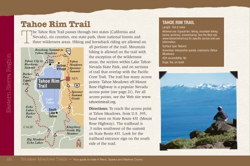
Tahoe Rim Trail<br />
The Tahoe Rim Trail passes through two states (California and<br />
<strong>Nevada</strong>), six counties, one state park, three national forests and<br />
three wilderness areas. Hiking and horseback riding are allowed on<br />
Tahoe City to<br />
Brockway<br />
Summit<br />
Barker<br />
Pass<br />
Tahoe<br />
City<br />
Echo<br />
Lakes<br />
Barker<br />
Pass<br />
CALIF.<br />
Brockway Summit to<br />
Tahoe <strong>Meadows</strong><br />
Big Meadow<br />
Echo Lakes<br />
Kings<br />
Beach<br />
Tahoe Rim<br />
Trail<br />
Lake<br />
Tahoe<br />
South<br />
Lake<br />
Tahoe<br />
Incline<br />
Village<br />
431<br />
Tahoe<br />
<strong>Meadows</strong><br />
Spooner<br />
Summit<br />
NEV.<br />
Spooner<br />
Summit<br />
Grade<br />
Kingsbury<br />
Grade Big<br />
Meadow<br />
all portions of the trail. Mountain<br />
biking is allowed on the trail with<br />
the exception of the wilderness<br />
areas, the section within Lake Tahoe-<br />
<strong>Nevada</strong> State Park, and on sections<br />
of trail that overlap with the Pacifi c<br />
Crest Trail. The trail has many access<br />
points: Tahoe <strong>Meadows</strong> off Mount<br />
Rose Highway is a popular <strong>Nevada</strong><br />
access point (see page 21). For all<br />
access points, see the Web site www.<br />
tahoerimtrail.org.<br />
Directions: To reach the access point<br />
at Tahoe <strong>Meadows</strong>, from U.S. 395,<br />
head west on State Route 431 (Mount<br />
Rose Highway). The trailhead is<br />
.5 miles southwest of the summit<br />
on State Route 431. Look for the<br />
trailhead entrance sign on the south<br />
side of the road.<br />
22 <strong>Truckee</strong> <strong>Meadows</strong> <strong>Trails</strong> — Your guide to trails in Reno, Sparks and <strong>Washoe</strong> <strong>County</strong><br />
50<br />
TAHOE RIM TRAIL<br />
Length: 164.8 miles<br />
Allowed use: Equestrian, hiking, mountain biking<br />
(some sections), snowshoeing. See the Web site<br />
www.tahoerimtrail.org for specifi c access and use<br />
information.<br />
Surface type: Natural<br />
Amenities: Interpretive panels, restrooms (Tahoe<br />
<strong>Meadows</strong>)<br />
ADA accessibility: No<br />
Dogs: Yes, on leash