HOW TWEED SAND BYPASSING WORKS - Tweed River Entrance ...
HOW TWEED SAND BYPASSING WORKS - Tweed River Entrance ...
HOW TWEED SAND BYPASSING WORKS - Tweed River Entrance ...

You also want an ePaper? Increase the reach of your titles
YUMPU automatically turns print PDFs into web optimized ePapers that Google loves.
TRESBP FACT SHEET 2<br />
<strong>Tweed</strong> <strong>River</strong> <strong>Entrance</strong> Sand Bypassing Project (TRESBP)<br />
www.tweedsandbypass.nsw.gov.au<br />
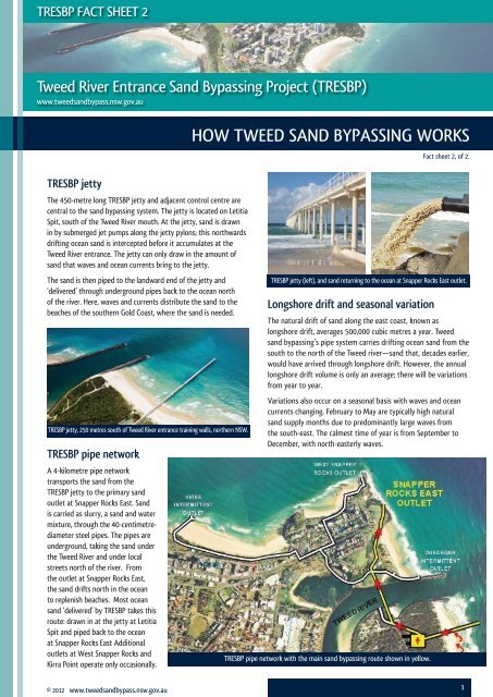
TRESBP jetty<br />
The 450-metre long TRESBP jetty and adjacent control centre are<br />
central to the sand bypassing system. The jetty is located on Letitia<br />
Spit, south of the <strong>Tweed</strong> <strong>River</strong> mouth. At the jetty, sand is drawn<br />
in by submerged jet pumps along the jetty pylons; this northwards<br />
drifting ocean sand is intercepted before it accumulates at the<br />
<strong>Tweed</strong> <strong>River</strong> entrance. The jetty can only draw in the amount of<br />
sand that waves and ocean currents bring to the jetty.<br />
The sand is then piped to the landward end of the jetty and<br />
‘delivered’ through underground pipes back to the ocean north<br />
of the river. Here, waves and currents distribute the sand to the<br />
beaches of the southern Gold Coast, where the sand is needed.<br />
TRESBP jetty, 250 metres south of <strong>Tweed</strong> <strong>River</strong> entrance training walls, northern NSW.<br />
TRESBP pipe network<br />
A 4-kilometre pipe network<br />
transports the sand from the<br />
TRESBP jetty to the primary sand<br />
outlet at Snapper Rocks East. Sand<br />
is carried as slurry, a sand and water<br />
mixture, through the 40-centimetrediameter<br />
steel pipes. The pipes are<br />
underground, taking the sand under<br />
the <strong>Tweed</strong> <strong>River</strong> and under local<br />
streets north of the river. From<br />
the outlet at Snapper Rocks East,<br />
the sand drifts north in the ocean<br />
to replenish beaches. Most ocean<br />
sand ‘delivered’ by TRESBP takes this<br />
route: drawn in at the jetty at Letitia<br />
Spit and piped back to the ocean<br />
at Snapper Rocks East Additional<br />
outlets at West Snapper Rocks and<br />
Kirra Point operate only occasionally.<br />
© 2012 www.tweedsandbypass.nsw.gov.au<br />
<strong>HOW</strong> <strong>TWEED</strong> <strong>SAND</strong> <strong>BYPASSING</strong> <strong>WORKS</strong><br />
Longshore drift and seasonal variation<br />
Fact sheet 2, of 2.<br />
TRESBP jetty (left), and sand returning to the ocean at Snapper Rocks East outlet.<br />
The natural drift of sand along the east coast, known as<br />
longshore drift, averages 500,000 cubic metres a year. <strong>Tweed</strong><br />
sand bypassing’s pipe system carries drifting ocean sand from the<br />
south to the north of the <strong>Tweed</strong> river—sand that, decades earlier,<br />
would have arrived through longshore drift. However, the annual<br />
longshore drift volume is only an average; there will be variations<br />
from year to year.<br />
Variations also occur on a seasonal basis with waves and ocean<br />
currents changing. February to May are typically high natural<br />
sand supply months due to predominantly large waves from<br />
the south-east. The calmest time of year is from September to<br />
December, with north-easterly waves.<br />
TRESBP pipe network with the main sand bypassing route shown in yellow.<br />
1
Duranbah Beach<br />
Just south of the TRESBP pipe outlet at Snapper Rocks East is<br />
Duranbah Beach, highly regarded for surfi ng (see aerial image on<br />
page one showing these locations). Duranbah, being south of the<br />
outlet, does not receive the benefi t of the ocean sand that fl ows<br />
through the pipe network and into the ocean to drift north from<br />
Snapper Rocks. Part of the TRESBP agreement between New South<br />
Wales and Queensland outlines that twice a year, and as needed<br />
after storm erosion, sand is piped onto Duranbah Beach through<br />
temporary pipes, erected for the purpose, to maintain beach and<br />
surfi ng conditions.<br />
The early years<br />
For the fi rst six years of <strong>Tweed</strong> sand bypassing operations, which<br />
commenced in 2001, large volumes of sand were transferred through<br />
the system. These volumes included additional sand, volumes in<br />
excess of the natural sand drift rate. This was carried out, following<br />
rigorous study, to rebuild the sand depleted beaches of the southern<br />
Gold Coast. These beaches had become severely eroded, from the<br />
1960s to the 1990s, as drifting ocean sand to replenish the beaches<br />
was blocked by the <strong>Tweed</strong> <strong>River</strong> entrance walls.<br />
The additional sand through the bypassing system was to<br />
compensate for three decades of ‘sand defi cit’ and to add the<br />
buffer that beaches require for the next round of severe seasonal<br />
storms. With this large volume of sand through the system in<br />
the early 2000s, southern Gold Coast beaches became very wide<br />
as far fewer than usual storms hit the Gold Coast during those<br />
years. Since 2007, and especially since 2009, there has been an<br />
acceleration of sand drifting northwards out of Coolangatta Bay<br />
owing to more frequent storms.<br />
2<br />
Image courtesy of McConnell Dowell Constructors<br />
Image courtesy of Gold Coast Tourism<br />
The Port Frederick, which periodically dredges the <strong>Tweed</strong> <strong>River</strong> entrance.<br />
The dredge<br />
A fl oating dredge periodically collects sand that drifts past the<br />
jetty pumps into the <strong>Tweed</strong> <strong>River</strong> entrance. Especially during<br />
stormy conditions, the TRESBP jetty can’t pick up all natural drift.<br />
The ocean-going dredge can be used for this missed sand. This<br />
supplementary dredging of the river entrance and nearshore<br />
areas adjacent to the South Head beach can help to maintain the<br />
navigation channel. It also allows for additional quantities of sand,<br />
when needed, to be placed off Point Danger. From here, natural<br />
swells deliver the sand to southern Gold Coast beaches<br />
TRESBP activity and sand volumes<br />
The volume of sand carried through the <strong>Tweed</strong> sand bypassing<br />
system varies. Calm conditions usually mean little or no sand to<br />
pump; while in higher wave conditions with large amounts of sand<br />
moving along the coast, pumping might be continuous.<br />
The current activity—whether pumping or dredging is occurring<br />
and why—is posted by TRESBP online, see www.tweedsandbypass.<br />
nsw.gov.au/current_activities The total volume of sand travelling<br />
through the system is also important to monitor. This volume,<br />
both up-to-date monthly and yearly fi gures as well as archival<br />
records, are also online. See www.tweedsandbypass.nsw.gov.au/<br />
sand_delivery<br />
The workings of the jetty<br />
TRESBP jetty intercepts sand that would have been ‘trapped’ by the<br />
rock walls at the <strong>Tweed</strong> <strong>River</strong> entrance, and the bypassing system<br />
‘delivers’ the sand back to the ocean. Pumping at the jetty is yearround<br />
and usually at night, drawing in the sand that waves and<br />
ocean currents bring to the jetty.<br />
The sand pumping process, works in stages:<br />
• Water from the nearby <strong>Tweed</strong> <strong>River</strong> is piped, under very high<br />
pressure, along the jetty and down into the ocean (see the<br />
downward white arrows).<br />
• There are ten jet pumps powered by water from the <strong>Tweed</strong> <strong>River</strong>,<br />
and these are spaced along the jetty pylons. These pumps use<br />
high pressure water to create a vacuum (Venturi effect) and have<br />
no moving parts. Four pumps operate at one time. The jet pumps<br />
extract sand from under the jetty, creating cone-shaped hollows<br />
in the seabed.<br />
• Clean ocean sand, drifting north, is drawn into this series of<br />
hollows. The sand is forced, by the pumps, from the bed of the<br />
ocean up to the jetty (the black arrows travelling up).<br />
• Sand and sea water travel to the landward end of the jetty by<br />
gravity, as the pipe is slightly angled. Here, a vibrating screen—<br />
working like a giant sieve—removes any waste. The slurry, or sand<br />
and water mixture, leaves the jetty and pumphouse area and is<br />
piped north by underground pipe.<br />
© 2012 www.tweedsandbypass.nsw.gov.au