

(1:50 000 Scale) Map Symbols - Mapzone - Ordnance Survey
(1:50 000 Scale) Map Symbols - Mapzone - Ordnance Survey
(1:50 000 Scale) Map Symbols - Mapzone - Ordnance Survey

Create successful ePaper yourself
Turn your PDF publications into a flip-book with our unique Google optimized e-Paper software.
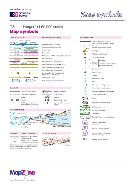
OS Landranger ®<br />
(1:<strong>50</strong> <strong>000</strong> scale)<br />
<strong>Map</strong> symbols<br />
ROADS AND PATHS<br />
Service area<br />
S<br />
Junction number<br />
1 Elevated<br />
M1<br />
A 493<br />
B 4518<br />
A 855<br />
B 885<br />
Ferry P Ferry V<br />
<strong>50</strong><br />
144<br />
Unfenced<br />
A 470<br />
RAILWAYS<br />
Bridge<br />
Footbridge<br />
Dual carriageway<br />
Track multiple or single<br />
Track under construction<br />
Siding<br />
Tunnel<br />
WATER FEATURES<br />
Light rapid transit system,<br />
narrow gauge or tramway<br />
Not necessarily rights of way<br />
Motorway (dual carriageway)<br />
Motorway under construction<br />
Primary Route<br />
Main road<br />
Primary Route / Main road under construction<br />
Secondary road<br />
Narrow road with passing places<br />
Road generally more than 4m wide<br />
Road generally less than 4m wide<br />
Path / Other road, drive or track<br />
Gradient: 20% (1 in 5) and steeper,<br />
14% (1 in 7) to 20% (1 in 5)<br />
Gates / Road Tunnel<br />
Ferry (passenger) / Ferry (vehicle)<br />
LC<br />
a<br />
Bridges / Footbridge<br />
Level crossing<br />
Station, (a) principal<br />
Marsh or salting<br />
Slopes<br />
Cliff<br />
Shingle<br />
Aqueduct<br />
Towpath Lock<br />
Canal<br />
Ford<br />
Weir Normal tidal limit<br />
: Beacon<br />
Sand<br />
Dunes<br />
Flat rock<br />
Lighthouse<br />
(disused) L<br />
l Lighthouse<br />
(in use)<br />
Lake Footbridge Bridge<br />
Mud<br />
Canal (dry)<br />
High water mark<br />
HEIGHTS 1 metre = 3.2808 feet ROCK FEATURES<br />
Contours are at 10 metres<br />
vertical interval<br />
Heights are to the nearest<br />
metre above mean sea level<br />
Heights shown close to a triangulation pillar<br />
refer to the ground at the base of the pillar<br />
and not necessarily to the summit.<br />
www.ordnancesurvey.co.uk/mapzone<br />
Outcrop<br />
Viaduct<br />
Light rapid transit system<br />
station<br />
600<br />
Low water mark<br />
6<strong>50</strong><br />
Cliff<br />
Scree<br />
V<br />
LAND FEATURES<br />
V<br />
[<br />
]<br />
{<br />
t<br />
E (<br />
W<br />
\<br />
o<br />
`<br />
Ù<br />
X<br />
ruin<br />
V<br />
Electricity transmission line<br />
(pylons shown at standard spacing)<br />
Pipe line<br />
(arrow indicates direction of flow)<br />
Buildings<br />
Public building (selected)<br />
Bus or coach station<br />
Place of<br />
worship<br />
Chimney or tower<br />
Glass structure<br />
Heliport<br />
Triangulation pillar<br />
Mast<br />
Wind pump / wind generator<br />
Windmill with or without sails<br />
Graticule intersection at 5’ intervals<br />
Quarry<br />
Spoil heap, refuse tip or dump<br />
Coniferous wood<br />
Non-coniferous wood<br />
Mixed wood<br />
with tower<br />
Cutting / embankment<br />
Orchard / Park or ornamental ground<br />
Forestry Commission<br />
access land<br />
with spire, minaret or dome<br />
without such additions<br />
National Trust-always open<br />
National Trust-limited access,<br />
observe local signs<br />
National Trust for Scotland
OS Landranger ®<br />
(1:<strong>50</strong> <strong>000</strong> scale)<br />
<strong>Map</strong> symbols<br />
PUBLIC RIGHTS OF WAY<br />
Danger Area<br />
Footpath<br />
Bridleway<br />
Road used as a public path<br />
Byway open to all traffic<br />
The symbols show the defined route so far<br />
as the scale of mapping will allow. Rights of<br />
way are not shown on maps of Scotland.<br />
The representation on this map of any other<br />
road, track or path is no evidence of the<br />
existence of a right of way<br />
Firing and Test Ranges in<br />
the area. Danger!<br />
Observe warning notices.<br />
OTHER PUBLIC ACCESS<br />
4 8<br />
BOUNDARIES ANTIQUITIES<br />
National<br />
District<br />
County, Unitary Authority,<br />
Metropolitan District<br />
or London Borough<br />
National Park<br />
/<br />
B<br />
Other route with public access<br />
(not normally shown in urban<br />
areas). Alignments are based on<br />
the best information available.<br />
These routes are not shown on<br />
maps of Scotland.<br />
National Trail, European Long<br />
Distance Route, Long Distance<br />
Route, selected Recreational<br />
Routes<br />
National/Regional Cycle Network<br />
Surfaced cycle route<br />
National/Regional Cycle Network<br />
number<br />
Site of monument<br />
Stone monument<br />
Battlefield (with date)<br />
Visible earthwork<br />
Roman<br />
Non-Roman<br />
NB. Due to changes in specification there are differences on some sheets<br />
TOURIST INFORMATION<br />
c<br />
n<br />
g<br />
H<br />
i I<br />
d<br />
P&R<br />
p P&R<br />
P<br />
T<br />
8<br />
Ê<br />
…<br />
y<br />
T<br />
ABBREVIATIONS<br />
CG<br />
CH<br />
MP<br />
MS<br />
Coastguard<br />
Clubhouse<br />
Milepost<br />
Milestone<br />
Camp site<br />
Garden<br />
Golf course or links<br />
Information centre, all year / seasonal<br />
Parking, Park and ride, all year / seasonal<br />
Picnic site<br />
Selected places of tourist interest<br />
Telephone, public / motoring organisation<br />
Viewpoint<br />
Visitor centre<br />
<strong>Ordnance</strong> <strong>Survey</strong>, the OS Symbol and OS Landranger are registered trademarks of <strong>Ordnance</strong> <strong>Survey</strong>, the national mapping agency of Great Britain.<br />
Made, printed and published by <strong>Ordnance</strong> <strong>Survey</strong>, Southampton, United Kingdom. For educational use only.<br />
www.ordnancesurvey.co.uk/mapzone<br />
Caravan site<br />
Nature reserve<br />
Walks / Trails<br />
Youth hostel<br />
P<br />
PC<br />
PH<br />
TH<br />
Post office<br />
Public convenience (in rural areas)<br />
Public house<br />
Town Hall, Guildhall or equivalent<br />
July 2002<br />
© Crown copyright 2002