Deep Creek fossicking area (Gympie) - Queensland Mining and Safety
Deep Creek fossicking area (Gympie) - Queensland Mining and Safety
Deep Creek fossicking area (Gympie) - Queensland Mining and Safety

You also want an ePaper? Increase the reach of your titles
YUMPU automatically turns print PDFs into web optimized ePapers that Google loves.
In 1867 a discovery of alluvial gold<br />
in a gully near the Mary River<br />
began the first major gold rush in<br />
<strong>Queensl<strong>and</strong></strong>, rescued the Colony's<br />
economy <strong>and</strong> founded the mining<br />
town of <strong>Gympie</strong>. Today tourists <strong>and</strong><br />
holidaymakers can still visit <strong>and</strong> try<br />
their luck in a gold-bearing gully in<br />
the town, at the <strong>Deep</strong> <strong>Creek</strong><br />
Fossicking Area. This <strong>area</strong> was set<br />
aside for fossickers in 1986 <strong>and</strong> is<br />
controlled by the Department of<br />
Mines <strong>and</strong> Energy <strong>and</strong> the Cooloola<br />
Shire Council under the Fossicking<br />
Act 1994.<br />
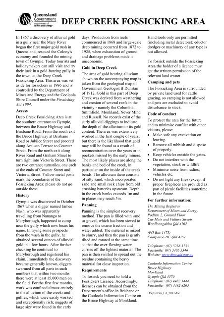
Access<br />
<strong>Deep</strong> <strong>Creek</strong> Fossicking Area is at<br />
the southern entrance to <strong>Gympie</strong>,<br />
between the Bruce Highway <strong>and</strong><br />
Brisbane Road. From the south exit<br />
the Bruce Highway at Brisbane<br />
Road or Jubilee Street <strong>and</strong> proceed<br />
along Araluen Terrace to Counter<br />
Street. From the north exit along<br />
River Road <strong>and</strong> Graham Street to<br />
turn right into Victoria Street. There<br />
are two entrance turnstiles, one each<br />
at the ends of Counter Street <strong>and</strong><br />
Victoria Street. Yellow metal posts<br />
mark the boundaries of the<br />
Fossicking Area; please do not go<br />
outside these.<br />
History<br />
<strong>Gympie</strong> was discovered in October<br />
1867 when a digger named James<br />
Nash, who was apparently<br />
travelling from Nanango to<br />
Maryborough, happened to camp<br />
near the gully which now bears his<br />
name. In trying some prospects<br />
from the wash in the gully, he<br />
obtained several ounces of alluvial<br />
gold in a few hours. After further<br />
checking he continued to<br />
Maryborough <strong>and</strong> registered his<br />
claim. Immediately the discovery<br />
became generally known, diggers<br />
swarmed from all parts in such<br />
numbers that within two months<br />
there were at least 15,000 men on<br />
the field. For the first few months,<br />
work was confined almost entirely<br />
to the alluvium of the creeks <strong>and</strong><br />
gullies, which were easily worked<br />
<strong>and</strong> exceptionally rich; nuggets of<br />
large size were found in the early<br />
DEEP CREEK FOSSICKING AREA<br />
days. Production from reefs<br />
commenced in 1868 <strong>and</strong> large-scale<br />
deep mining occurred from 1872 to<br />
1925, when exhaustion of ground<br />
<strong>and</strong> drainage problems made it<br />
uneconomic.<br />
Gold in <strong>Deep</strong> <strong>Creek</strong><br />
The <strong>area</strong> of gold bearing alluvium<br />
shown on the accompanying map is<br />
taken from the geological map of<br />
Government Geologist B Dunstan<br />
of 1912. Gold in this part of <strong>Deep</strong><br />
<strong>Creek</strong> was derived from weathering<br />
<strong>and</strong> erosion of several reefs in the<br />
vicinity - namely the Columbia,<br />
Smithfield, Monkl<strong>and</strong>, Never Mind<br />
<strong>and</strong> Russell. No records exist of the<br />
early alluvial diggings to indicate<br />
the depth of the alluvium or its gold<br />
content. The <strong>area</strong> was extensively<br />
worked in the first couple of years,<br />
but there is the likelihood that gold<br />
may still be found as a result of<br />
reconcentration over the years or in<br />
pockets missed by the early miners.<br />
The most likely places are along the<br />
banks <strong>and</strong> bed of the creek, in<br />
particular on the inside of the creek<br />
bends. The alluvium there consists<br />
of silty s<strong>and</strong>, which incorporates<br />
s<strong>and</strong> <strong>and</strong> small rock chips from old<br />
crushing batteries upstream. Depth<br />
in the creek banks exceeds 1m <strong>and</strong><br />
in places may reach 5m.<br />
Panning<br />
Panning is the simplest recovery<br />
method. The pan is filled with s<strong>and</strong><br />
or gravel, which has been sieved to<br />
remove the coarse fraction <strong>and</strong><br />
water added. The material is mixed<br />
to slurry, <strong>and</strong> then the pan is gently<br />
tilted <strong>and</strong> rotated at the same time<br />
so that the over-flowing water<br />
carries off the lightest material. The<br />
pan is then swirled to spread out the<br />
residue containing the heavy<br />
material for close inspection.<br />
Requirements<br />
To fossick you need to hold a<br />
Fossickers Licence. Accordingly,<br />
licences can be obtained from the<br />
Department's office in Brisbane or<br />
the Cooloola Information Centre on<br />
the Bruce Highway at Monkl<strong>and</strong>.<br />
H<strong>and</strong> tools only are permitted<br />
(including metal detectors); eductor<br />
dredges or machinery of any type is<br />
not allowed.<br />
To fossick outside the Fossicking<br />
Area the holder of a licence must<br />
get the written permission of the<br />
relevant l<strong>and</strong> owner.<br />
Camping <strong>and</strong> pets<br />
The Fossicking Area is surrounded<br />
by private l<strong>and</strong> used for cattle<br />
grazing, so camping is not allowed<br />
<strong>and</strong> pets are excluded to avoid<br />
disturbance to stock.<br />
Code of conduct<br />
To protect the <strong>area</strong> for the future<br />
<strong>and</strong> to minimise conflict with other<br />
visitors, please:<br />
• Make safe any excavation on<br />
leaving.<br />
• Remove all rubbish <strong>and</strong> dispose<br />
of properly.<br />
• Keep vehicles outside the gates.<br />
• Do not interfere with the<br />
vegetation, stock or wildlife.<br />
• Minimise noise from radios,<br />
vehicles etc.<br />
• Do not light any fires (except if<br />
proper fireplaces are provided as<br />
part of picnic facilities sometime<br />
in the future.<br />
For further information:<br />
The <strong>Mining</strong> Registrar<br />
Department of Mines <strong>and</strong> Energy<br />
Podium 2, Ground Floor<br />
Cnr Main <strong>and</strong> Vulture Streets<br />
Woolloongabba Qld 4102<br />
(PO Box 1475)<br />
Coorparoo DC Qld 4151<br />
Telephone: (07) 3238 3733<br />
Facsimile: (07) 3405 5346<br />
Website: www.dme.qld.gov.au<br />
Cooloola Information Centre<br />
Bruce Highway<br />
Monkl<strong>and</strong><br />
<strong>Gympie</strong> Qld 4570<br />
Telephone: (07) 4482 5444<br />
Facsimile: (07) 4482 8205<br />
<strong>Deep</strong> <strong>Creek</strong>_FA_2007.doc
Mary<br />
<br />
Ã<br />
1257+ &2$67 5$,/:$<<br />
<br />
<br />
<br />
<br />
<br />
<br />
<strong>Deep</strong><br />
<br />
<br />
<br />
<br />
<br />
<strong>Deep</strong><strong>Deep</strong><br />
River<br />
<br />
<br />
<strong>Creek</strong><br />
<br />
<strong>Creek</strong><br />
Ã<br />
ÃÃ<br />
'((3 &5((.<br />
)266,&.,1*<br />
$5($<br />
<br />
<br />
<br />
Boundary<br />
9,&725,$<br />
<br />
<br />
<br />
<br />
<br />
<br />
LEGEND<br />
Direction Sign<br />
Entrance Sign<br />
à <br />
52$'<br />
*8//< 67<br />
%5,6%$1( 52$'<br />
<strong>Creek</strong><br />
ÃÃÃ<br />
<br />
+,// 675((7<br />
&2817(5<br />
67<br />
LEGEND<br />
Boundary<br />
Boundary marker<br />
Entrance Sign<br />
Gold Bearing Wash<br />
<br />
Ã