QZSS Overview Quasi-Zenith Satellite System
QZSS Overview Quasi-Zenith Satellite System
QZSS Overview Quasi-Zenith Satellite System

Create successful ePaper yourself
Turn your PDF publications into a flip-book with our unique Google optimized e-Paper software.
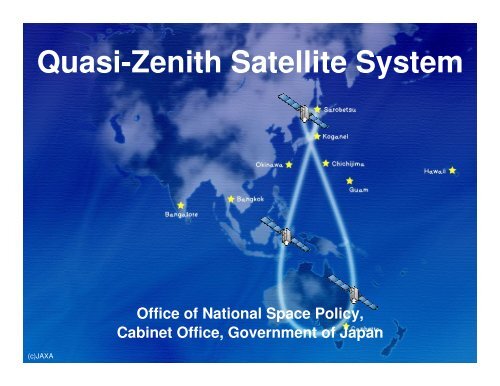
<strong>Quasi</strong>-<strong>Zenith</strong> <strong>Satellite</strong> <strong>System</strong><br />
(c)JAXA<br />
Office of National Space Policy,<br />
Cabinet Office, Government of Japan
<strong>QZSS</strong> <strong>Overview</strong><br />
<strong>Quasi</strong>-<strong>Zenith</strong> <strong>Satellite</strong> <strong>System</strong><br />
Functional Capability:<br />
GNSS Complementary<br />
GNSS Augmentation<br />
Messaging Service<br />
Coverage: Asia and Pacific region<br />
Signals:<br />
L1C/A, L1C, L2C and L5<br />
L1S (L1-SAIF) on 1575.42 MHz<br />
L6 (LEX) on 1278.75MHz<br />
First <strong>QZSS</strong> satellite “MICHIBIKI”<br />
Four satellites constellation shall be established and the<br />
service will start in 2018.<br />
2
<strong>QZSS</strong> Functional Capability 1<br />
GPS Complementary<br />
<strong>QZSS</strong> improves positioning<br />
availability time<br />
Navigation signals L1-C/A, L1C,<br />
L2C, and L5 sent from high<br />
elevation will improve the time<br />
percentage of positioning<br />
availability from 90 % (GPS only) to<br />
99.8 % * (GPS + <strong>QZSS</strong>.)<br />
* The time percentage that the position dilution of<br />
precision (PDOP) is less than 6 when a satellite<br />
whose elevation angle is 20 degrees or over is<br />
used for positioning calculation.<br />
GPS<br />
QZS<br />
3
<strong>QZSS</strong> Functional Capability 2<br />
GPS Augmentation<br />
GNSS Earth<br />
Observation<br />
Network<br />
<strong>QZSS</strong> improves positioning accuracy and reliability<br />
Ground Segment<br />
Augmentation<br />
Data Generation<br />
Global Monitoring Stations<br />
<strong>QZSS</strong><br />
Navigation Signal<br />
Galileo<br />
GPS GLONASS<br />
Navigation Signal and<br />
Augmentation Data<br />
User Segment<br />
L6 L1S<br />
centimeter (accuracy ) sub-meter<br />
4
<strong>QZSS</strong> Functional Capability 2<br />
GPS Augmentation<br />
Ground Segment<br />
GNSS Earth<br />
Observation<br />
Network<br />
Augmentation<br />
Data Generation<br />
Global Monitoring Stations<br />
Sub-meter Class Augmentation<br />
<strong>QZSS</strong><br />
Using GPS only ~ 10m<br />
Sub-meter class<br />
Augmentation Data<br />
L1S (250 bps)<br />
Using <strong>QZSS</strong><br />
Augmentation<br />
Signal<br />
~ 2m<br />
5
<strong>QZSS</strong> Functional Capability 2<br />
GPS Augmentation<br />
Ground Segment<br />
GNSS Earth<br />
Observation<br />
Network<br />
Augmentation<br />
Data Generation<br />
Global Monitoring Stations<br />
Centimeter Class Augmentation<br />
<strong>QZSS</strong><br />
Real-time Users (cm level accuracy)<br />
Centimeter class<br />
Augmentation Data<br />
L6 (2000 bps)<br />
Precise Survey IT Construction IT Agriculture<br />
6
<strong>QZSS</strong> Functional Capability 3<br />
Messaging Service<br />
<strong>QZSS</strong> can send short messages<br />
•<strong>QZSS</strong> can send short messages such as emergency warnings simultaneously to<br />
everyone with a mobile phone.<br />
Ground<br />
Segment<br />
<strong>QZSS</strong><br />
TSUNAMI!<br />
TSUNAMI<br />
Evacuation<br />
Instruction<br />
Go to xxxxxx<br />
Earthquake! 7
Basic policy on the implementation of the<br />
operational <strong>QZSS</strong> project<br />
Cabinet Decision on September 30, 2011<br />
GOJ has decided to accelerate the deployment of the<br />
operational <strong>QZSS</strong> as expeditiously as possible.<br />
Four satellites constellation shall be established by<br />
the late 2010s.<br />
In the future, seven satellites constellation shall be<br />
completed to enable sustainable positioning.<br />
The Cabinet Office shall develop, deploy and operate<br />
the operational <strong>QZSS</strong>, based on the achievement of<br />
the first <strong>QZSS</strong> satellite MICHIBIKI, and shall submit a<br />
budget request to cover relevant cost.<br />
Legal amendments shall be made in order for the<br />
Cabinet Office to fulfill such a role in time for budget<br />
implementation.<br />
8
QZS-1 MICHIBIKI Operation Status Up Date<br />
Accuracy : Signal-in-space User Range Error (SIS-URE)<br />
MICHIBIKI SIS-URE meets its specification, within +/- 2.6m (95%).<br />
Its SIS-URE(RMS) is about 40cm & less than that of GPS’s target, about 90cm*.<br />
(*refer to GPS Program Update to CGSIC 2011)<br />
© JAXA.<br />
9
Master Plan of <strong>QZSS</strong><br />
FY 2012 2013 ------ 2016 2017 2018 2019 ------ ------ 2031 2032<br />
Development<br />
(~6 years)<br />
4 constellation<br />
Operation<br />
(15 years)<br />
The Cabinet Office shall develop, deploy and<br />
operate <strong>QZSS</strong>.<br />
Four satellites constellation shall be established and<br />
the service will start in 2018.<br />
The four satellites constellation will consist of three<br />
QZSs (IGSOs) and one GEO satellite.<br />
In the future, seven satellites constellation shall be<br />
completed to enable sustainable positioning.<br />
10