QZSS Overview Quasi-Zenith Satellite System
QZSS Overview Quasi-Zenith Satellite System
QZSS Overview Quasi-Zenith Satellite System

Create successful ePaper yourself
Turn your PDF publications into a flip-book with our unique Google optimized e-Paper software.
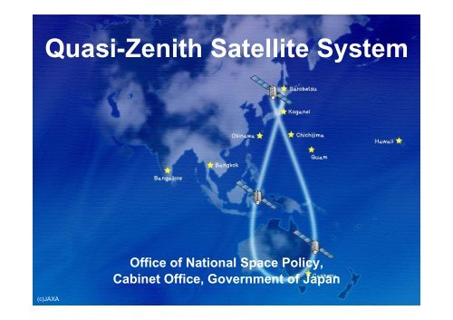
<strong>Quasi</strong>-<strong>Zenith</strong> <strong>Satellite</strong> <strong>System</strong><br />
(c)JAXA<br />
Office of National Space Policy,<br />
Cabinet Office, Government of Japan
<strong>QZSS</strong> <strong>Overview</strong><br />
<strong>Quasi</strong>-<strong>Zenith</strong> <strong>Satellite</strong> <strong>System</strong><br />
Functional Capability:<br />
GNSS Complementary<br />
GNSS Augmentation<br />
Messaging Service<br />
Coverage: Asia and Pacific region<br />
Signals:<br />
L1C/A, L1C, L2C and L5<br />
L1S (L1-SAIF) on 1575.42 MHz<br />
L6 (LEX) on 1278.75MHz<br />
First <strong>QZSS</strong> satellite “MICHIBIKI”<br />
Four satellites constellation shall be established and the<br />
service will start in 2018.<br />
2
Timeline of <strong>QZSS</strong> (planned)<br />
FY 2012 2013 ------ 2016 2017 2018 2019 ------ ------ 2031 2032<br />
Development<br />
(~6 years)<br />
Operation<br />
(15 years)<br />
3
<strong>QZSS</strong> Functional Capability 1<br />
GPS Complementary<br />
<strong>QZSS</strong> improves positioning<br />
availability time<br />
Navigation signals L1-C/A, L1C,<br />
L2C, and L5 sent from high<br />
elevation will improve the time<br />
percentage of positioning<br />
availability from 90 % (GPS only) to<br />
99.8 % * (GPS + <strong>QZSS</strong>.)<br />
* The time percentage that the position dilution of<br />
precision (PDOP) is less than 6 when a satellite<br />
whose elevation angle is 20 degrees or over is<br />
used for positioning calculation.<br />
GPS<br />
QZS<br />
4
<strong>QZSS</strong> Functional Capability 2<br />
GPS Augmentation<br />
GNSS Earth<br />
Observation<br />
Network<br />
<strong>QZSS</strong> improves positioning accuracy and reliability<br />
Ground Segment<br />
Augmentation<br />
Data Generation<br />
Global Monitoring Stations<br />
<strong>QZSS</strong><br />
Navigation Signal<br />
Galileo<br />
GPS GLONASS<br />
Navigation Signal and<br />
Augmentation Data<br />
User Segment<br />
L6 L1S<br />
centimeter (accuracy ) sub-meter<br />
5
<strong>QZSS</strong> Functional Capability 2<br />
GPS Augmentation<br />
Ground Segment<br />
GNSS Earth<br />
Observation<br />
Network<br />
Augmentation<br />
Data Generation<br />
Global Monitoring Stations<br />
Sub-meter Class Augmentation<br />
<strong>QZSS</strong><br />
Using GPS only ~ 10m<br />
Sub-meter class<br />
Augmentation Data<br />
L1S (250 bps)<br />
Using <strong>QZSS</strong><br />
Augmentation<br />
Signal<br />
~ 2m<br />
6
<strong>QZSS</strong> Functional Capability 2<br />
GPS Augmentation<br />
Ground Segment<br />
GNSS Earth<br />
Observation<br />
Network<br />
Augmentation<br />
Data Generation<br />
Global Monitoring Stations<br />
Centimeter Class Augmentation<br />
<strong>QZSS</strong><br />
Real-time Users (cm level accuracy)<br />
Centimeter class<br />
Augmentation Data<br />
L6 (2000 bps)<br />
Precise Survey IT Construction IT Agriculture<br />
7
<strong>QZSS</strong> Functional Capability 3<br />
Messaging Service<br />
<strong>QZSS</strong> can send short messages<br />
•<strong>QZSS</strong> can send short messages such as emergency warnings simultaneously to<br />
everyone with a mobile phone.<br />
Ground<br />
Segment<br />
<strong>QZSS</strong><br />
TSUNAMI!<br />
TSUNAMI<br />
Evacuation<br />
Instruction<br />
Go to xxxxxx<br />
Earthquake! 8
<strong>QZSS</strong> Update<br />
Basic policy on the implementation of the<br />
operational <strong>QZSS</strong> project (Cabinet Decision on<br />
September 30, 2011)<br />
The Government of Japan has decided to accelerate<br />
the deployment of the operational <strong>QZSS</strong> as<br />
expeditiously as possible.<br />
Verification of QZS-1 MICHIBIKI<br />
Technical Verification by JAXA<br />
Application Verification by private companies<br />
9
Basic policy on the implementation of the<br />
operational <strong>QZSS</strong> project (1)<br />
Cabinet Decision on September 30, 2011<br />
The <strong>QZSS</strong> will contribute to<br />
Welfare of the Asia and Pacific region<br />
Broad range of security<br />
including the improvement<br />
the capacity to respond to<br />
natural disasters<br />
<strong>QZSS</strong> <strong>Satellite</strong> Ground Track<br />
10
Basic policy on the implementation of the<br />
operational <strong>QZSS</strong> project (2)<br />
Cabinet Decision on September 30, 2011<br />
GOJ has decided to accelerate the deployment of the<br />
operational <strong>QZSS</strong> as expeditiously as possible.<br />
Four satellites constellation shall be established by<br />
the late 2010s.<br />
In the future, seven satellites constellation shall be<br />
completed to enable sustainable positioning.<br />
The Cabinet Office shall develop, deploy and operate<br />
the operational <strong>QZSS</strong>, based on the achievement of<br />
the first <strong>QZSS</strong> satellite MICHIBIKI, and shall submit a<br />
budget request to cover relevant cost.<br />
Legal amendments shall be made in order for the<br />
Cabinet Office to fulfill such a role in time for budget<br />
implementation.<br />
11
<strong>QZSS</strong> Technical Verification of QZS-1 MICHIBIKI<br />
Accuracy : Signal-in-space User Range Error (SIS-URE)<br />
MICHIBIKI SIS-URE meets its specification, within +/- 2.6m (95%).<br />
Its SIS-URE(RMS) is about 40cm & less than that of GPS’s target, about 90cm*.<br />
(*refer to GPS Program Update to CGSIC 2011)<br />
© JAXA.<br />
12
<strong>QZSS</strong> Technical Verification of QZS-1 MICHIBIKI<br />
Availability Improvement in Ginza, Tokyo (Feb. 19, 2011)<br />
Reference route<br />
Positioning result of GPS stand-alone use<br />
Positioning result of GPS+<strong>QZSS</strong> combination use<br />
Date of Observation: 2011/2/19<br />
250 minutes driving observation data<br />
during 6:00-12:30 obtained under JAXA-<br />
Melco joint research experiment<br />
Single Frequency DGPS positioning<br />
Availability<br />
GPS:39.5%<br />
GPS+<strong>QZSS</strong>:69.1%<br />
© JAXA.<br />
13
<strong>QZSS</strong> Technical Verification of QZS-1 MICHIBIKI<br />
Accuracy Improvement using augmentation signal L1-SAIF<br />
from MICHIBIKI<br />
[ m ]<br />
N<br />
|<br />
S<br />
(c)SPAC<br />
Comparison with positioning<br />
accuracy for GPS stand-alone<br />
use and for GPS+L1-SAIF signal<br />
use (24 hours observation)<br />
E-W<br />
[ m ]<br />
Positioning Error(RMS)<br />
Horizontal<br />
GPS Only 1.56m<br />
GPS+<br />
L1-SAIF<br />
Vertical<br />
0.46m<br />
GPS Only 3.85m<br />
GPS+<br />
L1-SAIF<br />
0.57m<br />
* Observation Point<br />
GPS-based control station<br />
in Kawagoe, Japan, 5/3/2011<br />
* SAIF : Submeter-class Augmentation<br />
with Integrity Function, conformable<br />
to SBAS signal<br />
14
Master Plan of <strong>QZSS</strong><br />
The Cabinet Office shall develop, deploy and<br />
operate <strong>QZSS</strong>.<br />
Four satellites constellation shall be established<br />
and the service will start in 2018.<br />
The four satellites constellation will consist of<br />
three QZSs (IGSOs) and one GEO satellite.<br />
In the future, seven satellites constellation shall<br />
be completed to enable sustainable positioning.<br />
15