

Daffodil Walk Feb. 2010 No. 3 - The Black Swan
Daffodil Walk Feb. 2010 No. 3 - The Black Swan
Daffodil Walk Feb. 2010 No. 3 - The Black Swan

You also want an ePaper? Increase the reach of your titles
YUMPU automatically turns print PDFs into web optimized ePapers that Google loves.
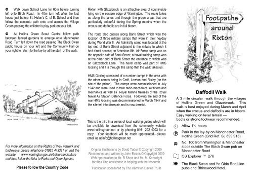
<strong>Walk</strong> down School Lane for 60m before turning<br />
left onto Birch Road. In 40m turn left after the last<br />
house just before St. Helen’s C. of E. School and then<br />
follow the concrete path onto and across the Village<br />
Green passing the children’s play park on your left.<br />
At Hollins Green Scout Centre follow path<br />
between fenced gardens to emerge onto Manchester<br />
Road. Turn left down the road passing <strong>The</strong> <strong>Black</strong> <strong>Swan</strong><br />
public house on your left and the Community Hall on<br />
your right to return to the lay-by at the start of the walk.<br />
For more information on the Rights of Way network and<br />
bridleways please telephone 01925 443321 or visit the<br />
website: www.warrington.gov.uk/Leisureandculture<br />
and then follow the links to Parks and Open Spaces.<br />
Please follow the Country Code<br />
<strong>The</strong> <strong>Black</strong> <strong>Swan</strong><br />
Rixton with Glazebrook is an attractive area of countryside<br />
lying on the eastern edge of Warrington. <strong>The</strong> route takes<br />
us along the lanes and through the green areas that are<br />
particularly colourful during the Spring months when the<br />
crocus and daffodils are in full bloom.<br />
<strong>The</strong> route also passes along Bank Street which was the<br />
location of three military camps that were in their heyday<br />
during World War II. An Admiralty camp was located at the<br />
top end of Bank Street adjacent to the railway to which it<br />
had direct access; an American 8th. Air Force camp was on<br />
the opposite side of Bank Street; a naval training camp was<br />
at the other end of Bank Street the entrance to which was<br />
on Glazebrook Lane. <strong>The</strong> naval camp was part of HMS<br />
Gosling and it is through this camp that the walk takes us.<br />
HMS Gosling consisted of a number camps in the area with<br />
the other camps being in Croft, Lowton and Risley (on the<br />
site of the prison). <strong>The</strong> camps were commissioned in July<br />
1942 and were used to train radio mechanics, air fitters and<br />
mechanics as well as Royal Marine trainees of the Royal<br />
Naval Air Station Defence Force. Following the end of the<br />
war HMS Gosling was decommissioned in March 1947 and<br />
the site fell into disrepair and is now derelict.<br />
This is the third in a series of local walking guides which will<br />
be available to download from the community website<br />
www.hollinsgreen.net or by phoning 0161 222 4003 for a<br />
copy. Your feedback will be much appreciated—please<br />
email us at info@hollinsgreen.net<br />
Original illustrations by David Tudor © Copyright 2009<br />
Researched and written by John Eccles © Copyright 2009<br />
With appreciation to Mr. R Shaw and Mr. M. Kenwright<br />
for their kind assistance in helping with the research.<br />
Publication sponsored by <strong>The</strong> Hamilton Davies Trust<br />
<strong>Daffodil</strong> <strong>Walk</strong><br />
A 3 mile circular walk through the villages<br />
of Hollins Green and Glazebrook. This<br />
walk is best enjoyed during March and April<br />
when the crocus and daffodils are in bloom.<br />
Easy walking on level terrain —<br />
boots or strong footwear recommended.<br />
<br />
<br />
<br />
<br />
Allow 1½ hours<br />
Park in the lay-by on Manchester Road,<br />
Hollins Green (Grid Ref. SJ 699 913)<br />
<strong>No</strong>. 100 from Warrington & Manchester<br />
stops outside <strong>The</strong> <strong>Black</strong> <strong>Swan</strong> pub on<br />
Manchester Road<br />
OS Explorer 276<br />
<strong>The</strong> <strong>Black</strong> <strong>Swan</strong> and Ye Olde Red Lion<br />
pubs and Rhinewood Hotel.
<strong>The</strong> walk starts from the lay-by on Manchester<br />
Road between <strong>The</strong> <strong>Black</strong> <strong>Swan</strong> pub and<br />
Glazebrook Lane traffic lights, known locally<br />
as <strong>Swan</strong> Brew.<br />
From the lay-by cross over Manchester Road.<br />
Turn right and in 20m turn left onto the path crossing<br />
stile by metal gate. Cross next stile in 30m into field<br />
and follow path keeping hedge and then fence on your<br />
right for 90m to junction. At junction bear left up the<br />
step then continue along edge of field towards the<br />
houses, keeping hedge with ditch on your right.<br />
After 220m emerge onto Dam Lane and turn<br />
right passing a detached house on your right (named<br />
Wayside). Continue along lane for 700m, passing a<br />
shooting range on your right, to the junction with Dam<br />
Head Lane at Hollingreave farm.<br />
Turn right and proceed up Dam Head Lane. After<br />
crossing the railway bridge continue on the lane around<br />
the bend before turning right down Bank Street and<br />
crossing over the railway once more. Continue down<br />
the length of Bank Street, passing the disused military<br />
camp on your right, for 800m. Just before the junction<br />
with Glazebrook Lane enter Glazebrook Village Green<br />
through a wooden gate on your right hand side.<br />
Glazebrook Village Green<br />
Plan of <strong>Walk</strong><br />
Birch Road<br />
School<br />
Red Lion<br />
Scout<br />
Centre<br />
Village Green<br />
<br />
A57<br />
School Lane<br />
<br />
<br />
<strong>Black</strong><br />
<strong>Swan</strong><br />
Start Point<br />
Dam Lane<br />
Cemetery<br />
Wayside<br />
Diagonally cross the village green, from which the<br />
Post Office can be seen, to the far corner on Glazebrook<br />
Lane. Turn right up the lane and 60m after crossing the<br />
short cul-de-sac look for the path on your right by the<br />
wooden pylon opposite Carlton Way. Turn right onto the<br />
path between the hedge and the pylon to enter the derelict<br />
naval camp HMS Gosling.<br />
Follow the path for 50m as it winds to a junction.<br />
Turn left following path with trees to your left and raised<br />
ground to your right until reaching a path joining from the<br />
right. Ignore this path continuing straight on as path gently<br />
winds to a farmer’s field in 60m. Enter the field and follow<br />
path straight ahead to the right of the fence between the<br />
two fields.<br />
In 110m ignore path to right that crosses the field<br />
and keep straight on following the fence line. In a further<br />
60m ignore the waymark pointing left for the path that<br />
crosses the hedge line and continue on the path bearing to<br />
the right towards the houses on Dam Lane.<br />
<br />
<br />
<br />
Hollingreave<br />
Farm<br />
Dam Lane<br />
Shooting<br />
Range<br />
<br />
<br />
Glazebrook Lane B 5212<br />
Dam Head Lane<br />
<br />
USAF Camp<br />
(disused)<br />
Village<br />
Green<br />
Emerge onto Dam Lane and turn left passing the<br />
detached house ’Wayside’ on your left. Continue up<br />
Dam Lane, passing the cemetery in 170m, before turning<br />
right at the cenotaph into School Lane.<br />
Bank Street<br />
HMS Gosling<br />
Naval Camp (derelict)<br />
Site of<br />
Admiralty Camp<br />
<br />
PO<br />
Cenotaph & St. Helen’s Church