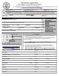
FLOOD ZONE DETERMINATION FORM - City of Baton Rouge ...
FLOOD ZONE DETERMINATION FORM - City of Baton Rouge ...
FLOOD ZONE DETERMINATION FORM - City of Baton Rouge ...

Create successful ePaper yourself
Turn your PDF publications into a flip-book with our unique Google optimized e-Paper software.
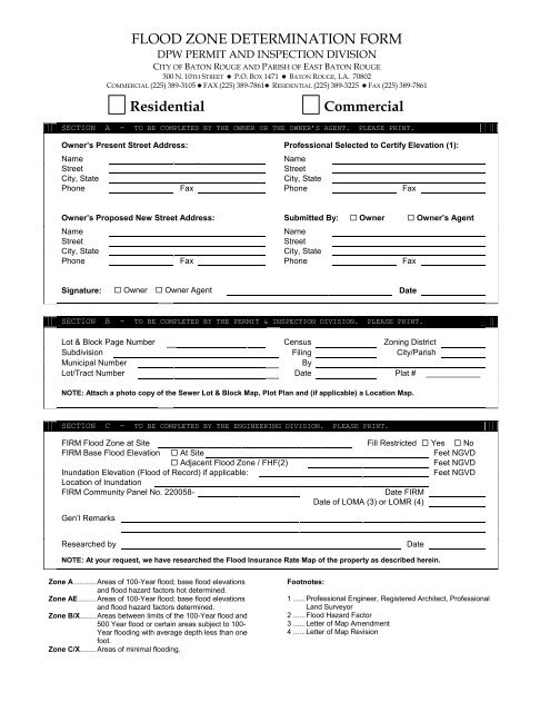
<strong>FLOOD</strong> <strong>ZONE</strong> <strong>DETERMINATION</strong> <strong>FORM</strong><br />
DPW PERMIT AND INSPECTION DIVISION<br />
CITY OF BATON ROUGE AND PARISH OF EAST BATON ROUGE<br />
300 N. 10TH STREET P.O. BOX 1471 BATON ROUGE, LA. 70802<br />
COMMERCIAL (225) 389-3105 FAX (225) 389-7861 RESIDENTIAL (225) 389-3225 FAX (225) 389-7861<br />
Residential Commercial<br />
SECTION A - TO BE COMPLETED BY THE OWNER OR THE OWNER’S AGENT. PLEASE PRINT.<br />
Owner’s Present Street Address: Pr<strong>of</strong>essional Selected to Certify Elevation (1):<br />
Name Name<br />
Street Street<br />
<strong>City</strong>, State <strong>City</strong>, State<br />
Phone Fax Phone Fax<br />
Owner’s Proposed New Street Address: Submitted By: Owner Owner’s Agent<br />
Name Name<br />
Street Street<br />
<strong>City</strong>, State <strong>City</strong>, State<br />
Phone Fax Phone Fax<br />
<br />
<br />
Signature: Owner Owner Agent Date<br />
<br />
SECTION B - TO BE COMPLETED BY THE PERMIT & INSPECTION DIVISION. PLEASE PRINT.<br />
Lot & Block Page Number Census Zoning District<br />
Subdivision Filing <strong>City</strong>/Parish<br />
Municipal Number By<br />
Lot/Tract Number Date Plat # ____________<br />
NOTE: Attach a photo copy <strong>of</strong> the Sewer Lot & Block Map, Plot Plan and (if applicable) a Location Map.<br />
<br />
SECTION C - TO BE COMPLETED BY THE ENGINEERING DIVISION. PLEASE PRINT.<br />
FIRM Flood Zone at Site Fill Restricted Yes No<br />
FIRM Base Flood Elevation At Site Feet NGVD<br />
Adjacent Flood Zone / FHF(2) Feet NGVD<br />
Inundation Elevation (Flood <strong>of</strong> Record) if applicable: Feet NGVD<br />
Location <strong>of</strong> Inundation<br />
FIRM Community Panel No. 220058- Date FIRM<br />
Date <strong>of</strong> LOMA (3) or LOMR (4)<br />
Gen’l Remarks<br />
Researched by Date<br />
NOTE: At your request, we have researched the Flood Insurance Rate Map <strong>of</strong> the property as described herein.<br />
<br />
Zone A ........... Areas <strong>of</strong> 100-Year flood; base flood elevations<br />
and flood hazard factors hot determined.<br />
Zone AE ......... Areas <strong>of</strong> 100-Year flood; base flood elevations<br />
and flood hazard factors determined.<br />
Zone B/X........ Areas between limits <strong>of</strong> the 100-Year flood and<br />
500 Year flood or certain areas subject to 100-<br />
Year flooding with average depth less than one<br />
foot.<br />
Zone C/X........ Areas <strong>of</strong> minimal flooding.<br />
Footnotes:<br />
1 ...... Pr<strong>of</strong>essional Engineer, Registered Architect, Pr<strong>of</strong>essional<br />
Land Surveyor<br />
2 ...... Flood Hazard Factor<br />
3 ...... Letter <strong>of</strong> Map Amendment<br />
4 ...... Letter <strong>of</strong> Map Revision
COMPLETING THE <strong>FLOOD</strong> <strong>ZONE</strong> <strong>DETERMINATION</strong> <strong>FORM</strong><br />
The <strong>City</strong>-Parish Flood Ordinance requires that you first complete Section A <strong>of</strong> the Flood Zone Determination<br />
Form prior to applying for a building permit. This process will determine the lowest elevation at which you<br />
may construct your floor.<br />
Completing Your (the owner) Section<br />
1. Provide a plot plan and complete Section A <strong>of</strong> the Flood Zone Determination Form.<br />
2. Section B will be completed by the Permit and Inspection Division. We will forward it to the DPW<br />
Engineering Division for further processing.<br />
3. You will be notified by your selected pr<strong>of</strong>essional (the individual you named on Section A <strong>of</strong> the form)<br />
when the lowest floor elevation has been determined.<br />
SECTION<br />
A<br />
TO BE COMPLETED BY OWNER OR OWNER'S AGENT. PLEASE<br />
PRI NT.<br />
Owner's Present Street Address: Pr<strong>of</strong>essional Selected to Certify Elevation (1):<br />
Name Name<br />
Street Street<br />
<strong>City</strong>, State <strong>City</strong>, State<br />
Phone Fax Phone Fax<br />
Owner's Proposed New Street Address: Submitted By: Owner Owner's Agent<br />
Name Name<br />
Street Street<br />
<strong>City</strong>, State <strong>City</strong>, State<br />
Phone Fax Phone Fax<br />
Signature: Owner Owner's Agent Date:<br />
SECTION<br />
TO BE COMPLETED BY DPW I NSPECTI ON DI VI SI ON. PLEASE<br />
B<br />
PRI NT.<br />
Lot & Block Page Number: Census No: Zoning Dist:<br />
Subdivision: Filing: <strong>City</strong>/Parish:<br />
Municipal Number: By:<br />
Lot/Tract Number: Date:<br />
NOTE: Attach a photo copy <strong>of</strong> the Sewer Lot & Block Map, Plot Plan and (if applicable) a Location Map.<br />
SECTION<br />
C<br />
TO BE COMPLETED BY DPW ENGI NEERI NG. PLEASE<br />
PRI NT.<br />
Researched By: Date:<br />
FIRM Flood Zone at Site: Fill Restricted: No Yes<br />
FIRM Base Flood Elev: At Site: Feet NGVD<br />
Adjacent Flood Zone / FHF(2): Feet NGVD<br />
Inundation Elevation (Flood <strong>of</strong> Record) if applicable: Feet NGVD<br />
Location <strong>of</strong> Inundation:<br />
FIRM Community Panel No. 220058- Date, FIRM:<br />
Remarks: Date, LOMA(3) or LOMR (4):<br />
At your request, we have researched the Flood Insurance Rate Map <strong>of</strong> the property described above with the aforementioned results.<br />
The Flood Zone Determination Form<br />
4. Your selected pr<strong>of</strong>essional can then complete a Proposed Certificate <strong>of</strong> Elevation form.