Inventory to the Gordon and Lorna Walmsley fonds held at the ...
Inventory to the Gordon and Lorna Walmsley fonds held at the ...
Inventory to the Gordon and Lorna Walmsley fonds held at the ...

Create successful ePaper yourself
Turn your PDF publications into a flip-book with our unique Google optimized e-Paper software.
<strong>Inven<strong>to</strong>ry</strong> <strong>to</strong> <strong>the</strong><br />
GORDON AND LORNA WALMSLEY FONDS<br />
<strong>held</strong> <strong>at</strong> <strong>the</strong> Yukon Archives<br />
March 1990<br />
Reprinted 2003
<strong>Inven<strong>to</strong>ry</strong> <strong>to</strong> <strong>the</strong><br />
GORDON AND LORNA WALMSLEY FONDS<br />
Held by <strong>the</strong> Yukon Archives<br />
Yukon Archives<br />
March 1990, Reprinted 2003<br />
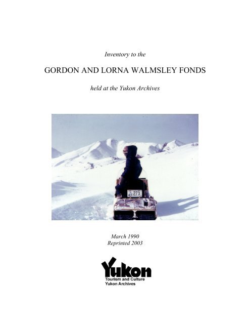
Cover pho<strong>to</strong>graph: Yukon Archives. <strong>Gordon</strong> <strong>and</strong> <strong>Lorna</strong> <strong>Walmsley</strong> <strong>fonds</strong>, #12857 “<strong>Lorna</strong> <strong>Walmsley</strong><br />
skidooing in <strong>the</strong> Depmster area near <strong>the</strong> foot of <strong>the</strong> summit of <strong>the</strong> Ogilvie Mountains <strong>at</strong> <strong>the</strong> North Fork<br />
Pass”
TABLE OF CONTENTS<br />
FONDS DESCRIPTION ......................................................................................................................................... 3<br />
CAPTION LIST....................................................................................................................................................... 5<br />
DAWSON CITY AND SURROUNDING AREA.......................................................................................................... 5<br />
WILDLIFE (YUKON AND ALASKA) .................................................................................................................... 49<br />
HUNTING TRIPS IN THE YUKON......................................................................................................................... 59<br />
NORTH CANOL ROAD AREA.............................................................................................................................. 83<br />
SOUTH CANOL ROAD AREA .............................................................................................................................. 89<br />
FARO - PELLY RIVER - ROSS RIVER - LITTLE SALMON AREA......................................................................... 95<br />
ALASKA ............................................................................................................................................................ 107<br />
SKIDOO TRIPS (NOT INCLUDING THE TRIP TO N.W.T.)................................................................................... 111<br />
FORT SELKIRK AREA ....................................................................................................................................... 115<br />
CAMPBELL HIGHWAY AREA............................................................................................................................ 119<br />
KUSAWA LAKE AREA ...................................................................................................................................... 121<br />
KLUANE PARK - HAINES HIGHWAY AREA ..................................................................................................... 125<br />
WHITEHORSE AREA ......................................................................................................................................... 127<br />
BENNETT LAKE AREA...................................................................................................................................... 129<br />
WALMSLEYS’ FRIENDS.................................................................................................................................... 131<br />
NORTHWEST TERRITORIES .............................................................................................................................. 133<br />
CARMACKS - FIVE FINGER RAPIDS AREA....................................................................................................... 135<br />
CLINTON CREEK – FORTYMILE AREA............................................................................................................. 137<br />
NORTHWEST BRITISH COLUMBIA AREA......................................................................................................... 139<br />
STEWART RIVER / WHITEHORSE..................................................................................................................... 141<br />
MACMILLAN RIVER - PELLY CROSSING AREA............................................................................................... 143<br />
CARCROSS AREA.............................................................................................................................................. 145<br />
MISCELLANEOUS.............................................................................................................................................. 147<br />
NORTHWEST TERRITORIES .............................................................................................................................. 151<br />
ROSS RIVER - LIVINGSTONE CREEK ............................................................................................................... 153<br />
LOWER LAKE LABERGE AREA......................................................................................................................... 155<br />
MISCELLANEOUS.............................................................................................................................................. 157<br />
APPENDIX 1: SUBJECTS ................................................................................................................................. 163
FONDS DESCRIPTION<br />
GORDON AND LORNA WALMSLEY FONDS. — 1954-1974<br />
Physical Description:<br />
4,002 pho<strong>to</strong>graphs : col. slides.<br />
Biographical Sketch:<br />
<strong>Gordon</strong> <strong>Walmsley</strong> (born 1 September 1921) came <strong>to</strong> Dawson City in 1946 <strong>and</strong> <strong>Lorna</strong> Coldron<br />
(born 25 April 1920) arrived in 1947. <strong>Lorna</strong> Coldron's fa<strong>the</strong>r, Percy Coldron, was in <strong>the</strong> Yukon during<br />
<strong>the</strong> Gold Rush <strong>and</strong> was a member of <strong>the</strong> Yukon Order of Pioneers. <strong>Gordon</strong> <strong>and</strong> <strong>Lorna</strong> <strong>Walmsley</strong> were<br />
married in Dawson City in 1950. <strong>Gordon</strong> <strong>Walmsley</strong> was employed first as an electrical superintendent<br />
for Yukon Consolid<strong>at</strong>ed Gold Corpor<strong>at</strong>ion <strong>and</strong> l<strong>at</strong>er as a power superintendent for <strong>the</strong> Nor<strong>the</strong>rn<br />
Canada Power Commission. <strong>Lorna</strong> <strong>Walmsley</strong> was employed as Secretary of <strong>the</strong> Yukon Gold<br />
Corpor<strong>at</strong>ion <strong>and</strong> l<strong>at</strong>er by <strong>the</strong> Dawson City Light <strong>and</strong> Power Company.<br />
The <strong>Walmsley</strong>'s moved <strong>to</strong> Faro in 1968 where <strong>Gordon</strong> continued working for <strong>the</strong> Nor<strong>the</strong>rn<br />
Canada Power Commission as superintendent. In Faro he was responsible for providing power for <strong>the</strong><br />
construction of <strong>the</strong> <strong>to</strong>wn of Faro <strong>and</strong> also began Faro's w<strong>at</strong>er system. In 1970 <strong>Gordon</strong> <strong>Walmsley</strong> was<br />
appointed <strong>to</strong> <strong>the</strong> Advisory Council for <strong>the</strong> Village of Faro, <strong>to</strong> serve until <strong>the</strong> election of <strong>the</strong> first<br />
Municipal Council for <strong>the</strong> village. In th<strong>at</strong> election in December 1970 he was voted in as alderman. In<br />
addition , he was Faro's first Justice of <strong>the</strong> Peace <strong>and</strong> coroner for <strong>the</strong> Faro -Ross River area.<br />
<strong>Lorna</strong> <strong>Walmsley</strong> was quite adventuresome <strong>and</strong> on one occasion she crossed <strong>the</strong> Arctic Circle<br />
in an Arctic Circle Hot Springs Flying Service airplane on 2 August 1949. <strong>Lorna</strong> <strong>Walmsley</strong> was an<br />
am<strong>at</strong>eur Yukon his<strong>to</strong>rian <strong>and</strong> wrote articles under ei<strong>the</strong>r her own or her pen name for <strong>the</strong> Whitehorse<br />
Star <strong>and</strong> The Alaska Magazine. Many of her pho<strong>to</strong>graphs have also been published. She was also <strong>the</strong><br />
first white woman <strong>to</strong> travel from Faro <strong>to</strong> Norman Wells, N .W. T. by skidoo. On <strong>the</strong> trip <strong>Gordon</strong> <strong>and</strong><br />
<strong>Lorna</strong> <strong>Walmsley</strong>, along with six o<strong>the</strong>rs, including Fa<strong>the</strong>r Rigaud of Faro <strong>and</strong> Bob Giesbrecht of Atlin,<br />
left Faro on 12 April 1973 <strong>and</strong> arrived in Norman Wells 13 days l<strong>at</strong>er.<br />
<strong>Lorna</strong> <strong>Walmsley</strong> died in Faro on 27 December 1974. <strong>Gordon</strong> <strong>Walmsley</strong> retired July 1975, <strong>and</strong><br />
after moving <strong>to</strong> Vancouver, bought a sailbo<strong>at</strong>. He named it "Fireweed II" after <strong>Lorna</strong> <strong>and</strong> spent his<br />
remaining years sailing <strong>the</strong> Pacific coast. He died 12 January 1985.<br />
<strong>Gordon</strong> <strong>and</strong> <strong>Lorna</strong> <strong>Walmsley</strong> both had a gre<strong>at</strong> love of <strong>the</strong> wilderness <strong>and</strong> spent much of <strong>the</strong>ir<br />
leisure time exploring <strong>the</strong> Yukon <strong>and</strong> <strong>the</strong> neighbouring areas of nor<strong>the</strong>rn British Columbia, Alaska <strong>and</strong><br />
<strong>the</strong> Northwest Terri<strong>to</strong>ries. They both enjoyed big game hunting <strong>and</strong> some of <strong>Lorna</strong> <strong>Walmsley</strong>'s<br />
trophies are <strong>to</strong>day displayed <strong>at</strong> <strong>the</strong> MacBride Museum in Whitehorse. Throughout <strong>the</strong>ir travels, <strong>the</strong><br />
<strong>Walmsley</strong>s, <strong>and</strong> more particularly <strong>Lorna</strong>, were accompanied by <strong>the</strong>ir camera.<br />
Scope <strong>and</strong> Content:<br />
The <strong>fonds</strong> consists of slides taken by <strong>Gordon</strong> <strong>and</strong> <strong>Lorna</strong> <strong>Walmsley</strong> depicting <strong>the</strong>ir travels in <strong>the</strong> Yukon<br />
from 1954 <strong>to</strong> 1974. Images include wildlife, flora, hunting trips, <strong>and</strong> news of Yukon communities,<br />
people, <strong>and</strong> events. The areas depicted in <strong>the</strong> slides include Dawson, Whitehorse, Fort Selkirk, Faro,<br />
Alaska, <strong>and</strong> <strong>the</strong> areas around Little Salmon, Canol Road, Campbell Highway, Kusawa Lake, <strong>and</strong><br />
Kluane Park.<br />
Source of Supplied Title Note:<br />
Title based on crea<strong>to</strong>rs of <strong>fonds</strong>.<br />
Arrangement:<br />
The slides have been maintained in <strong>the</strong> original subject groupings developed by <strong>Gordon</strong> <strong>and</strong> <strong>Lorna</strong><br />
<strong>Walmsley</strong> <strong>and</strong> were numbered in this arrangement by <strong>the</strong> archivist.<br />
3
<strong>Inven<strong>to</strong>ry</strong> <strong>to</strong> <strong>the</strong> <strong>Gordon</strong> <strong>and</strong> <strong>Lorna</strong> <strong>Walmsley</strong> <strong>fonds</strong><br />
Restrictions:<br />
There are no donor-imposed restrictions on this m<strong>at</strong>erial. General copyright or institutional or legal<br />
restrictions may apply.<br />
Finding Aid:<br />
Consult “<strong>Inven<strong>to</strong>ry</strong> <strong>to</strong> <strong>the</strong> <strong>Gordon</strong> <strong>and</strong> <strong>Lorna</strong> <strong>Walmsley</strong> <strong>fonds</strong> <strong>held</strong> <strong>at</strong> <strong>the</strong> Yukon Archives”.<br />
General Note:<br />
Funding <strong>to</strong> arrange <strong>and</strong> describe <strong>the</strong> <strong>Gordon</strong> <strong>and</strong> <strong>Lorna</strong> <strong>Walmsley</strong> slides was made possible by<br />
financial assistance from <strong>the</strong> federal government through <strong>the</strong> N<strong>at</strong>ional Archives of Canada, <strong>the</strong><br />
Canadian Council of Archives <strong>and</strong> <strong>the</strong> Yukon Archives.<br />
Selection Note:<br />
Slides in poor physical condition <strong>and</strong> slides containing images not rel<strong>at</strong>ing <strong>to</strong> <strong>the</strong> Yukon were returned<br />
<strong>to</strong> Bill <strong>Walmsley</strong>.<br />
Accession Number(s):<br />
87/69<br />
LOCATION:<br />
9732-13733 (87/69): C<strong>at</strong>alogued Pho<strong>to</strong>graphs<br />
4
CAPTION LIST<br />
The following is a slide-by-slide list of <strong>Gordon</strong> <strong>and</strong> <strong>Lorna</strong> <strong>Walmsley</strong>’s colour slides. If <strong>the</strong> d<strong>at</strong>e of <strong>the</strong><br />
slide was not known, <strong>the</strong> commercial processing d<strong>at</strong>es have been used. This is indic<strong>at</strong>ed by [ ].<br />
The slides have been maintained in <strong>the</strong> original subject groupings developed by <strong>the</strong> <strong>Walmsley</strong>s.<br />
Detailed subject access points are provided in Appendix 1.<br />
DAWSON CITY AND SURROUNDING AREA<br />
YA# Description D<strong>at</strong>e<br />
9732 Winter view of old sawmill - Dawson City [1960]<br />
9733 View of <strong>Walmsley</strong> home <strong>and</strong> front garden in Bear Creek 1960<br />
9734 View of <strong>Walmsley</strong> home <strong>and</strong> front garden in Bear Creek 1956<br />
9735 View of <strong>Walmsley</strong> home <strong>and</strong> front garden in Bear Creek 1956<br />
9736 View of <strong>Walmsley</strong> home <strong>and</strong> front garden in Bear Creek 1956<br />
9737 View of <strong>Walmsley</strong> home <strong>and</strong> front garden in Bear Creek 1960<br />
(Sept.)<br />
9738 View of <strong>the</strong> back of <strong>the</strong> <strong>Walmsley</strong> home <strong>and</strong> garden in Bear Creek can be<br />
seen in <strong>the</strong> background<br />
1960<br />
9739 View of <strong>the</strong> side garden of <strong>the</strong> <strong>Walmsley</strong> home in Bear Creek 1956<br />
9740 View of <strong>the</strong> back garden of <strong>the</strong> <strong>Walmsley</strong> home in Bear Creek 1956<br />
9741 View of <strong>the</strong> back garden of <strong>the</strong> <strong>Walmsley</strong> home in Bear Creek 1958<br />
9742 View of <strong>the</strong> back garden <strong>and</strong> greenhouse of <strong>the</strong> <strong>Walmsley</strong> home in Bear<br />
Creek<br />
1960<br />
9743 View of <strong>the</strong> backyard of <strong>the</strong> <strong>Walmsley</strong> home in winter in Bear Creek 1964<br />
9744 View of back garden <strong>and</strong> yard of <strong>the</strong> <strong>Walmsley</strong> home in Bear Creek 1960<br />
9745 <strong>Lorna</strong> <strong>Walmsley</strong> in front of <strong>Walmsley</strong> home in Bear Creek 1955<br />
9746 View of front garden <strong>and</strong> <strong>Walmsley</strong> home in Bear Creek 1956<br />
9747 View of front garden <strong>and</strong> <strong>Walmsley</strong> home in Bear Creek 1955<br />
9748 View of front garden <strong>and</strong> <strong>Walmsley</strong> home in Bear Creek 1958<br />
9749 View of back garden <strong>and</strong> greenhouse of <strong>the</strong> <strong>Walmsley</strong> home in Bear Creek 1958<br />
9750 View of back garden of <strong>the</strong> <strong>Walmsley</strong> home Bear Creek 19581<br />
9751 View of <strong>Walmsley</strong> home in Bear Creek 1956<br />
9752 View of <strong>Walmsley</strong> home in winter in Bear Creek n.d.<br />
9753 View of roses in garden of <strong>Walmsley</strong> home in Bear Creek 1954<br />
9754 View of roses in garden of <strong>Walmsley</strong> home in Bear Creek 1954<br />
9755 View of garden of <strong>the</strong> <strong>Walmsley</strong> home in Bear Creek 1956<br />
5
<strong>Inven<strong>to</strong>ry</strong> <strong>to</strong> <strong>the</strong> <strong>Gordon</strong> <strong>and</strong> <strong>Lorna</strong> <strong>Walmsley</strong> <strong>fonds</strong><br />
6<br />
YA# Description D<strong>at</strong>e<br />
9756 View of <strong>the</strong> woodshed vines <strong>at</strong> <strong>the</strong> <strong>Walmsley</strong> home in Bear Creek 1954<br />
9757 View of <strong>the</strong> woodshed vines <strong>and</strong> garden <strong>at</strong> <strong>the</strong> <strong>Walmsley</strong> home in Bear<br />
Creek<br />
1954<br />
9758 View of <strong>the</strong> garden <strong>at</strong> <strong>the</strong> <strong>Walmsley</strong> home in Bear Creek 1954<br />
9759 View of <strong>the</strong> garden <strong>at</strong> <strong>the</strong> <strong>Walmsley</strong> home in Bear Creek 1956<br />
9760 View of <strong>the</strong> greenhouse <strong>and</strong> garden <strong>at</strong> <strong>the</strong> <strong>Walmsley</strong> home in Bear Creek 1956<br />
9761 View of <strong>the</strong> inside of <strong>the</strong> greenhouse <strong>at</strong> <strong>the</strong> <strong>Walmsley</strong> home in Bear Creek 1958<br />
9762 View of <strong>the</strong> greenhouse <strong>at</strong> <strong>the</strong> <strong>Walmsley</strong> home in Bear Creek 1956<br />
9763 View of back garden <strong>at</strong> <strong>the</strong> <strong>Walmsley</strong> home in Bear Creek 1956<br />
9764 View of <strong>the</strong> back garden <strong>at</strong> <strong>the</strong> <strong>Walmsley</strong> home in Bear Creek 1956<br />
9765 View of <strong>the</strong> garden <strong>and</strong> front porch <strong>at</strong> <strong>the</strong> <strong>Walmsley</strong> home in Bear Creek n.d.<br />
9766 View of <strong>the</strong> <strong>Walmsley</strong> home in <strong>the</strong> spring in Bear Creek 1955<br />
9767 View of <strong>the</strong> side garden <strong>and</strong> <strong>the</strong> <strong>Walmsley</strong> home in Bear Creek 1960<br />
9768 View of <strong>the</strong> garden <strong>and</strong> <strong>the</strong> <strong>Walmsley</strong> home in Bear Creek 1956<br />
9769 View of <strong>the</strong> wheels in <strong>the</strong> back garden of <strong>the</strong> <strong>Walmsley</strong> home in Bear<br />
Creek<br />
9770 View of <strong>the</strong> cable reel <strong>and</strong> antlers in garden <strong>at</strong> <strong>the</strong> <strong>Walmsley</strong> home in Bear<br />
Creek<br />
9771 View of <strong>the</strong> back garden before <strong>the</strong> construction of <strong>the</strong> greenhouse <strong>at</strong> <strong>the</strong><br />
<strong>Walmsley</strong> home in Bear Creek<br />
1956<br />
1958<br />
1954<br />
9772 <strong>Lorna</strong> <strong>Walmsley</strong> in <strong>the</strong> back garden <strong>at</strong> <strong>the</strong> <strong>Walmsley</strong> home in Bear Creek 1955<br />
9773 Drake No. 10 [1966]<br />
9774 NLP & Company building which is <strong>the</strong> old Ladue Company Quartz Mill<br />
Building<br />
9775 <strong>Lorna</strong> <strong>Walmsley</strong> <strong>and</strong> Janice w<strong>at</strong>ching <strong>the</strong> Discovery Day Parade on Front<br />
Street, Dawson City in front of <strong>the</strong> old White Pass & Yukon Railway sheds<br />
(Aug l7)<br />
9776 <strong>Lorna</strong> <strong>Walmsley</strong> <strong>and</strong> Janice w<strong>at</strong>ching <strong>the</strong> Discovery Day Parade on Front<br />
Street, Dawson City in front of <strong>the</strong> White Pass & Yukon Railway sheds.<br />
(Aug l7)<br />
9777 View of <strong>the</strong> Little League flo<strong>at</strong> in <strong>the</strong> Discover Day Parade in Dawson City<br />
August l7)<br />
9778 Reception <strong>at</strong> <strong>the</strong> bo<strong>at</strong> docking ceremony on Discovery Day in Dawson City<br />
(Aug l7)<br />
[1966]<br />
n.d.<br />
n.d.<br />
n.d.<br />
1954<br />
9779 Bo<strong>at</strong> docking reception Hec<strong>to</strong>r in Dawson City (Aug 17) 1954<br />
9780 View of <strong>the</strong> flood <strong>at</strong> <strong>the</strong> White Pass & Yukon Railway office in Dawson<br />
City<br />
[1960]
Dawson City <strong>and</strong> Surrounding Area<br />
YA# Description D<strong>at</strong>e<br />
9781 View of <strong>the</strong> flood <strong>at</strong> <strong>the</strong> White Pass & Yukon Railway Office in Dawson<br />
City<br />
[1960]<br />
9782 View of <strong>the</strong> ferry <strong>and</strong> <strong>the</strong> ice jam in Dawson City [1960]<br />
9783 View of <strong>the</strong> flood <strong>at</strong> <strong>the</strong> Connelly <strong>and</strong> Dawson office in Dawson City [1964]<br />
9784 Gre<strong>at</strong> Nor<strong>the</strong>rn Airways office in Dawson City [1966]<br />
9785 View of <strong>the</strong> Connelly - Dawson Cessna on <strong>the</strong> river front in Dawson City 1958<br />
9786 View of planes on <strong>the</strong> river front in Dawson City [1966]<br />
9787 Kelly Connelly <strong>and</strong> John Wakefield in front of a de Havill<strong>and</strong> Beaver on<br />
<strong>the</strong> river front in Dawson City<br />
9788 Ron Connelly in front of a de Havill<strong>and</strong> Beaver in <strong>the</strong> river front in<br />
Dawson City<br />
9789 View of Dawson City from <strong>the</strong> West Dawson Campground - <strong>Lorna</strong><br />
<strong>Walmsley</strong> is in <strong>the</strong> foreground<br />
[1966]<br />
[1966]<br />
[1966]<br />
9790 Guide on <strong>the</strong> S.S. Keno in Dawson City [1966]<br />
9791 Bud Fisher <strong>and</strong> Sarah Rivers - Dawson City [1966]<br />
9792 S.S. Keno during <strong>the</strong> spring flood of l964 in Dawson City 1964<br />
9793 Yukon Field Force Plaque near <strong>the</strong> S.S. Keno in Dawson City [1969]<br />
9794 View of Dawson City [1966]<br />
9795 Winter view of Dawson City [1966]<br />
9796 Museum fire in Dawson City n.d.<br />
9797 Prime Minister John Diefenbaker, Erik Nielsen <strong>and</strong> Tommie in Dawson<br />
City<br />
1958<br />
9798 View of <strong>the</strong> Old Firehall, Dawson City during <strong>the</strong> Discovery Day Parade 1954<br />
9799 View of <strong>the</strong> Bank of Commerce surrounded by high w<strong>at</strong>er, Dawson City [1964]<br />
9800 View of <strong>the</strong> Bank of Commerce on <strong>the</strong> banks of <strong>the</strong> Yukon River filled<br />
with ice<br />
9801 Plaque commemor<strong>at</strong>ing Robert Service <strong>at</strong> <strong>the</strong> Canadian Imperial Bank of<br />
Commerce in Dawson City,<br />
9802 View of <strong>the</strong> ice jam <strong>and</strong> flood in front of <strong>the</strong> Canadian Imperial Bank of<br />
Commerce in Dawson City<br />
9803 View of <strong>the</strong> ice jam <strong>and</strong> flood in front of <strong>the</strong> Canadian Imperial Bank of<br />
Commerce in Dawson City, Yukon (<strong>the</strong> Old Firehall is in <strong>the</strong> background)<br />
9804 Gold Room Sign <strong>at</strong> <strong>the</strong> Canadian Imperial Bank of Commerce in Dawson<br />
City,<br />
[1960]<br />
[1966]<br />
[1960]<br />
[1960]<br />
[1966]<br />
9805 View of <strong>the</strong> Dawson Daily News Building in Dawson City [1966]<br />
9806 View of <strong>the</strong> Dawson Daily News Building in Dawson City [1966]<br />
7
<strong>Inven<strong>to</strong>ry</strong> <strong>to</strong> <strong>the</strong> <strong>Gordon</strong> <strong>and</strong> <strong>Lorna</strong> <strong>Walmsley</strong> <strong>fonds</strong><br />
8<br />
YA# Description D<strong>at</strong>e<br />
9807 View of Klondike Mo<strong>to</strong>rs Building in Dawson City [1966]<br />
9808 Klondike Mo<strong>to</strong>rs sign in Dawson City [1966]<br />
9809 View of <strong>the</strong> Hickey's Garage Flo<strong>at</strong> in <strong>the</strong> Discovery Day Parade in Dawson<br />
City. In <strong>the</strong> foreground are Irene <strong>and</strong> Will Crayford <strong>and</strong> daughter<br />
1954<br />
9810 Jack Colbourne [1966]<br />
9811 Road signs for Queen <strong>and</strong> Third Ave in Dawson City [1966]<br />
9812 <strong>Gordon</strong> <strong>Walmsley</strong> <strong>and</strong> Joe <strong>at</strong> <strong>the</strong> Government Liquor S<strong>to</strong>re in Dawson City [1966]<br />
9813 View of <strong>the</strong> Government Liquor S<strong>to</strong>re in Dawson City [1966]<br />
9814 View of <strong>the</strong> Government Liquor S<strong>to</strong>re <strong>and</strong> <strong>the</strong> Old Fire Hall in Dawson<br />
City<br />
9815 View of <strong>the</strong> Dawson City Fire Hall in Dawson City. In <strong>the</strong> foreground are<br />
Elmer <strong>and</strong> a fire engine<br />
[1966]<br />
[1966]<br />
9816 The old fire engine in Dawson City [1966]<br />
9817 The old fire engine in <strong>the</strong> Discovery Day Parade in Dawson City 1956<br />
9818 The Klondike Thawing <strong>and</strong> Machine Company in Dawson City [1966]<br />
9819 The American Hotel, Dawson City [1966]<br />
9820 Dan McDonald in front of <strong>the</strong> American Hotel in Dawson City [1966]<br />
9821 Old Building next <strong>to</strong> <strong>the</strong> American Hotel in Dawson City [1966]<br />
9822 Hackonson's Residence in Dawson City [1966]<br />
9823 Dawson Wholesale Building, Dawson City [1966]<br />
9824 Dawson Wholesale Building, Dawson City [1966]<br />
9825 View of <strong>the</strong> side of <strong>the</strong> Dawson Wholesale Building, Dawson City [1966]<br />
9826 North <strong>to</strong> Liquor S<strong>to</strong>re Sign in Dawson City [1966]<br />
9827 Westminister Hotel - Dawson City [1966]<br />
9828 Occidental Hotel on Third Ave, Dawson City [1966]<br />
9829 View of <strong>the</strong> Occidental Hotel & Westminister Hotel on third Ave, Dawson<br />
City<br />
9830 View of Occidental Hotel on Third Ave., Dawson City n.d.<br />
[1966]<br />
9831 Occidental Hotel in Dawson City [1966]<br />
9832 Occidental Hotel Sign in Dawson City [1966]<br />
9833 Occidental Hotel Flo<strong>at</strong> with Ole Christianson riding in Discovery Day<br />
Parade, Dawson City<br />
1958<br />
9834 Occidental Hotel in Dawson City [1966]<br />
9835 Bus Depot beside <strong>the</strong> Occidental Hotel, Dawson City [1966]<br />
9836 Margretta Gaudrove [1966]
Dawson City <strong>and</strong> Surrounding Area<br />
YA# Description D<strong>at</strong>e<br />
9837 Occidental Motel in Dawson City [1966]<br />
9838 Billy Bigg's Bicycle Shop, Dawson City [1966]<br />
9839 Red Fea<strong>the</strong>r Saloon, Dawson City [1966]<br />
9840 Third Ave. Blacksmith Shop, Dawson City [1966]<br />
9841 Guns <strong>and</strong> Ammunition Shop on Third Ave. Dawson City [1966]<br />
9842 Old Pho<strong>to</strong>graph Shop, Dawson City [1966]<br />
9843 View of Third Ave. in Dawson City [1966]<br />
9844 Black Milees Son sign & Wolf Skin in front of Billy Bigg's in Dawson<br />
City<br />
[1966]<br />
9845 7th Avenue Road sign in Dawson [1966]<br />
9846 Grant Henderson Grave [1966]<br />
9847 Majorettes <strong>at</strong> <strong>the</strong> Discovery Day Parade in Dawson City 1956<br />
9848 Old Henderson Residence in Dawson City [1966]<br />
9849 Jeckell Residence on 7th Ave., Dawson City [1966]<br />
9850 Colbourne's Cabin on 7th Ave. & King St., Dawson City [1966]<br />
9851 Caribou Painting on <strong>the</strong> side of Colbourne's (E<strong>the</strong>l's Cabin on 4th Ave. &<br />
King St., Dawson City<br />
[1966]<br />
9852 Dr. Rook's residence on 7th Ave., Dawson City [1966]<br />
9853 Retallack residence, Alec Wark Residence on 7th Ave., Dawson City [1966]<br />
9854 Bremner's residence on 7th Ave., Dawson City [1966]<br />
9855 7th Ave. cabins in Dawson City, John Gould's cabin is <strong>the</strong> one with <strong>the</strong> red<br />
roof<br />
[1966]<br />
9856 7th Ave. Log House. Williams residence, Dawson City [1966]<br />
9857 Hauulik's house on 4th Ave. S., Dawson City [1966]<br />
9858 Blondie Warville Residence on 7th Ave., & Bill Neilson's Residence on<br />
Princess St. & Harper St., Dawson City<br />
[1966]<br />
9859 Faulkner's cabin on 7th Ave., Dawson City [1966]<br />
9860 Faulkner's cabin on 7th Ave, Dawson City [1966]<br />
9861 Bill Scott's residence along with <strong>the</strong> Church <strong>and</strong> 8th Ave. road sign,<br />
Dawson City<br />
9862 Former Allen Residence on 8th Ave. between Church St. <strong>and</strong> Harper St.,<br />
Dawson City<br />
9863 Hill Residence (former Judge Residence) on 8th Ave. between Hanson St.<br />
& Church St., Dawson City<br />
[1966]<br />
[1966]<br />
[1966]<br />
9864 Robert Service's Cabin, Dawson City [1966]<br />
9
<strong>Inven<strong>to</strong>ry</strong> <strong>to</strong> <strong>the</strong> <strong>Gordon</strong> <strong>and</strong> <strong>Lorna</strong> <strong>Walmsley</strong> <strong>fonds</strong><br />
10<br />
YA# Description D<strong>at</strong>e<br />
9865 Robert Service's Cabin on 8th Ave. between Hanson St. & Church St,<br />
Dawson City<br />
9866 Robert Service Cabin, Dawson City 1957<br />
9867 Ac<strong>to</strong>r playing "Robert Service" in front of Robert Service Cabin, Dawson<br />
City<br />
n.d.<br />
[1966]<br />
9868 Robert Service Cabin, Dawson City 1957<br />
9869 Chris Grant (Les Millen) Residence on 7th Ave., Dawson City [1966]<br />
9870 Rogers farewell <strong>at</strong> <strong>the</strong> Teleps, Dawson City 1971<br />
9871 Ole Christensen's Residence, Dawson City [1966]<br />
9872 View of Little League Ballgame <strong>at</strong> <strong>the</strong> Min<strong>to</strong> Park looking <strong>to</strong>wards 7th &<br />
8th Avenues, Dawson City<br />
9873 Jack London Square Sign, Dawson City [1966]<br />
9874 Jack London's Cabin, Dawson City [1971]<br />
9875 P<strong>at</strong> <strong>and</strong> helicopter [1966]<br />
9876 P<strong>at</strong> Beaver airplane 1958<br />
9877 Collison's Flo<strong>at</strong> <strong>at</strong> <strong>the</strong> Discovery Day Parade, Dawson City, (Joan <strong>and</strong><br />
Pilot on board)<br />
n.d.<br />
1954<br />
9878 Emanuel Silver Reception <strong>at</strong> <strong>the</strong> Dawson Airport, Dawson City 1955<br />
9879 Emanuel Silver Reception <strong>at</strong> <strong>the</strong> Dawson Airport, Dawson City 1955<br />
9880 Emanuel Silver Reception <strong>at</strong> <strong>the</strong> Dawson Airport, Dawson City 1955<br />
9881 Emanuel Silver Reception <strong>at</strong> <strong>the</strong> Dawson Airport, Dawson City 1955<br />
9882 Emanuel Silver Reception <strong>at</strong> <strong>the</strong> Dawson Airport, Dawson City 1955<br />
9883 Crayfords fishing <strong>at</strong> 6th Ave. & Harper St., Dawson City n.d.<br />
9884 Cenotaph <strong>and</strong> Cannons <strong>at</strong> 5th Ave. & Church St. Dawson City [1966]<br />
9885 Old Administr<strong>at</strong>ion building - museum in Dawson City [1966]<br />
9886 Administr<strong>at</strong>ion Building sign in Dawson City, Yukon. Bill <strong>and</strong> Hazel are<br />
in foreground<br />
9887 Administr<strong>at</strong>ion Building which housed <strong>the</strong> Dawson Museum. Florence in<br />
<strong>the</strong> foreground<br />
9888 Pho<strong>to</strong>graphs of Ogilvie Henderson <strong>and</strong> McQuertin <strong>at</strong> <strong>the</strong> Dawson<br />
Museum, Dawson City<br />
1969<br />
[1966]<br />
[1966]<br />
9889 Mastadon Bones <strong>at</strong> <strong>the</strong> Dawson Museum in Dawson City [1966]<br />
9890 Dahl Sheep <strong>and</strong> Wolf in Dawson Museum, Dawson City [1966]<br />
9891 Pho<strong>to</strong>graph of Mrs. Silas 1966<br />
9892 Madeline Gould <strong>at</strong> <strong>the</strong> Dawson Museum, Dawson City 1966
Dawson City <strong>and</strong> Surrounding Area<br />
YA# Description D<strong>at</strong>e<br />
9893 Klondike Mine Railway Locomotive No. 1 <strong>at</strong> <strong>the</strong> Dawson Museum,<br />
Dawson City<br />
9894 Sign for <strong>the</strong> Klondike mine railway locomotive number 1 <strong>at</strong> <strong>the</strong> Dawson<br />
Museum, Dawson City<br />
9895 Copy of an early print of <strong>the</strong> Klondike mine railway locomotive number 1 n.d.<br />
9896 Older locomotive engines in Louse<strong>to</strong>wn n.d.<br />
[1966]<br />
[1966]<br />
9897 Klondike mine railway engines in Louse<strong>to</strong>wn 1956<br />
9898 Klondike mine railway engines Louse<strong>to</strong>wn n.d.<br />
9899 Klondike mine railway engines <strong>at</strong> Dawson Museum, Dawson City [1966]<br />
9900 Klondike mine railway engines <strong>at</strong> Dawson Museum, Dawson City [1966]<br />
9901 Old railway engine in Dawson City [1966]<br />
9902 Diamond stacker engine (?) <strong>at</strong> Dawson Museum, Dawson City [1966]<br />
9903 Klondike mine railway engine <strong>at</strong> Dawson Museum in Dawson City. Bill<br />
<strong>and</strong> Hazel are in <strong>the</strong> foreground<br />
1969<br />
9904 Old steam drill <strong>and</strong> steam trac<strong>to</strong>r <strong>at</strong> <strong>the</strong> Dawson Museum in Dawson City [1969]<br />
9905 Old steamer engine trac<strong>to</strong>r <strong>at</strong> <strong>the</strong> Dawson Museum, Dawson City [1969]<br />
9906 Klondike mine railway engine, Dawson City [1969]<br />
9907 Klondike mine railway engine <strong>and</strong> old wagon with <strong>Gordon</strong> <strong>Walmsley</strong>,<br />
Dawson City<br />
[1969]<br />
9908 Diamond stacker of <strong>the</strong> Klondike mine railway in Dawson City [1969]<br />
9909 Old Monarch <strong>and</strong> trac<strong>to</strong>r wagons of <strong>the</strong> Klondike mine railway, Dawson<br />
City, Florence <strong>and</strong> <strong>Gordon</strong> <strong>Walmsley</strong> are in <strong>the</strong> foreground<br />
[1969]<br />
9910 Klondike mine railway engine <strong>at</strong> <strong>the</strong> Dawson Museum, Dawson City [1969]<br />
9911 Old steam trac<strong>to</strong>r <strong>at</strong> <strong>the</strong> Dawson Museum, Dawson City [1966]<br />
9912 Klondike mine railway engines <strong>at</strong> <strong>the</strong> Dawson Museum, Dawson City [1969]<br />
9913 Administr<strong>at</strong>ion building <strong>and</strong> <strong>the</strong> Klondike mine railways engines in<br />
Dawson City<br />
9914 Flood <strong>at</strong> Min<strong>to</strong> Park in Dawson City with <strong>the</strong> railway engines in <strong>the</strong><br />
foreground<br />
[1966]<br />
[1964]<br />
9915 Flood on 5th Ave., Dawson City [1969]<br />
9916 Old Black Residence, Dawson City [1966]<br />
9917 Children <strong>at</strong> swimming pool, Dawson City [1966]<br />
9918 Aerial View of swimming pool, Dawson City [1966]<br />
9919 Gold Nugget Motel, Dawson City [1966]<br />
9920 Gold Nugget Motel sign in Dawson City [1966]<br />
11
<strong>Inven<strong>to</strong>ry</strong> <strong>to</strong> <strong>the</strong> <strong>Gordon</strong> <strong>and</strong> <strong>Lorna</strong> <strong>Walmsley</strong> <strong>fonds</strong><br />
12<br />
YA# Description D<strong>at</strong>e<br />
9921 Blubb Road during <strong>the</strong> flood in Dawson City [1966]<br />
9922 Near Ogilvie bridge during <strong>the</strong> flood, Dawson City [1966]<br />
9923 Near Ogilvie bridge during <strong>the</strong> flood, Dawson City [1966]<br />
9924 Bluff near Boutilliers during <strong>the</strong> flood in Dawson City [1966]<br />
9925 Road near <strong>the</strong> Bluff during <strong>the</strong> flood <strong>at</strong> Dawson City [1966]<br />
9926 Near <strong>the</strong> Ogilvie bridge during <strong>the</strong> flood <strong>at</strong> Dawson City [1966]<br />
9927 Mouth of <strong>the</strong> Klondike River during <strong>the</strong> flood <strong>at</strong> Dawson City [1966]<br />
9928 S<strong>and</strong>bagging during <strong>the</strong> flood <strong>at</strong> Dawson City [1966]<br />
9929 Mouth of <strong>the</strong> Klondike River during <strong>the</strong> flood <strong>at</strong> Dawson City, Yukon [1966]<br />
9930 View <strong>at</strong> <strong>the</strong> Plant during <strong>the</strong> flood <strong>at</strong> Dawson City [1966]<br />
9931 S<strong>and</strong>bagging <strong>at</strong> <strong>the</strong> bluff during <strong>the</strong> flood <strong>at</strong> Dawson City [1966]<br />
9932 S<strong>and</strong>bagging <strong>at</strong> <strong>the</strong> bluff during <strong>the</strong> flood <strong>at</strong> Dawson City [1966]<br />
9933 View of <strong>the</strong> bluff during <strong>the</strong> flood <strong>at</strong> Dawson City [1966]<br />
9934 The highway near <strong>the</strong> bluff during <strong>the</strong> flood <strong>at</strong> Dawson City [1966]<br />
9935 S<strong>and</strong>bagging near <strong>the</strong> bluff during <strong>the</strong> flood <strong>at</strong> Dawson City [1966]<br />
9936 S<strong>and</strong>bagging near <strong>the</strong> bluff during <strong>the</strong> flood <strong>at</strong> Dawson City [1966]<br />
9937 Near Hunker bridge during <strong>the</strong> flood <strong>at</strong> Dawson City [1966]<br />
9938 Near Hunker bridge during <strong>the</strong> flood <strong>at</strong> Dawson City [1966]<br />
9939 Near Hunker bridge during <strong>the</strong> flood <strong>at</strong> Dawson City [1966]<br />
9940 Rock Creek near <strong>the</strong> bluff during <strong>the</strong> flood <strong>at</strong> Dawson City. <strong>Gordon</strong><br />
<strong>Walmsley</strong> is in <strong>the</strong> foreground<br />
[1966]<br />
9941 Rock Creek near bluff during <strong>the</strong> flood <strong>at</strong> Dawson City [1966]<br />
9942 Klondike River during <strong>the</strong> flood <strong>at</strong> Dawson City [1966]<br />
9943 Klondike River during <strong>the</strong> flood <strong>at</strong> Dawson City [1966]<br />
9944 Klondike River during <strong>the</strong> flood <strong>at</strong> Dawson City [1966]<br />
9945 Klondike River during <strong>the</strong> flood <strong>at</strong> Dawson City [1966]<br />
9946 Klondike River during <strong>the</strong> flood [1966]<br />
9947 Rock Creek near bluff during <strong>the</strong> flood <strong>at</strong> Dawson City [1966]<br />
9948 Klondike River during <strong>the</strong> flood <strong>at</strong> Dawson City [1966]<br />
9949 Klondike Highway during <strong>the</strong> flood <strong>at</strong> Dawson City [1966]<br />
9950 2nd Avenue during <strong>the</strong> flood, Dawson City [1966]<br />
9951 South end of Dawson City during <strong>the</strong> flood [1966]<br />
9952 Dawson City during <strong>the</strong> flood [1966]
Dawson City <strong>and</strong> Surrounding Area<br />
YA# Description D<strong>at</strong>e<br />
9953 Dawson City during <strong>the</strong> flood [1966]<br />
9954 Dawson City during <strong>the</strong> flood (D.O.T. Residence) [1966]<br />
9955 Dawson City during <strong>the</strong> flood (D.O.T. Residence) [1966]<br />
9956 Front St. during <strong>the</strong> flood <strong>at</strong> Dawson City [1966]<br />
9957 Commissioner's residence during <strong>the</strong> flood <strong>at</strong> Dawson City [1966]<br />
9958 Gre<strong>at</strong> Nor<strong>the</strong>rn Airways building during <strong>the</strong> flood <strong>at</strong> Dawson City [1966]<br />
9959 Gre<strong>at</strong> Nor<strong>the</strong>rn Airways building during <strong>the</strong> flood <strong>at</strong> Dawson City [1966]<br />
9960 Canadian Imperial Bank of Commerce during <strong>the</strong> flood <strong>at</strong> Dawson City [1966]<br />
9961 Bank of Commerce during <strong>the</strong> flood <strong>at</strong> Dawson City [1966]<br />
9962 Behind <strong>the</strong> Canadian Imperial Bank of Commerce during <strong>the</strong> flood <strong>at</strong><br />
Dawson City<br />
[1966]<br />
9963 Dawson City during <strong>the</strong> flood. George Shaws residence [1966]<br />
9964 Dawson City during <strong>the</strong> flood. George Shaws residence [1966]<br />
9965 S.S. Keno during <strong>the</strong> flood <strong>at</strong> Dawson City [1966]<br />
9966 White Pass & Yukon Railway building during <strong>the</strong> flood <strong>at</strong> Dawson City [1966]<br />
9967 Yukon St. <strong>and</strong> Church St. during <strong>the</strong> flood <strong>at</strong> Dawson City [1966]<br />
9968 Yukon Order of Pioneers bldg. during <strong>the</strong> flood <strong>at</strong> Dawson City [1966]<br />
9969 Trout St. <strong>and</strong> <strong>the</strong> ferry during <strong>the</strong> flood <strong>at</strong> Dawson City [1966]<br />
9970 Ferry during <strong>the</strong> flood <strong>at</strong> Dawson City [1966]<br />
9971 Pole line <strong>at</strong> <strong>the</strong> ferry shack during <strong>the</strong> flood <strong>at</strong> Dawson City [1966]<br />
9972 Pole line crew during <strong>the</strong> flood <strong>at</strong> Dawson City [1966]<br />
9973 Ferry during <strong>the</strong> flood <strong>at</strong> Dawson City [1966]<br />
9974 Ferry during <strong>the</strong> flood <strong>at</strong> Dawson City [1966]<br />
9975 Commerce corner during <strong>the</strong> flood <strong>at</strong> Dawson City [1966]<br />
9976 Yukon River during <strong>the</strong> flood <strong>at</strong> Dawson City [1966]<br />
9977 Yukon River during <strong>the</strong> flood <strong>at</strong> Dawson City [1966]<br />
9978 W<strong>at</strong>er dyke <strong>and</strong> Camper during <strong>the</strong> flood <strong>at</strong> Dawson City [1966]<br />
9979 Yukon River during <strong>the</strong> flood <strong>at</strong> Dawson City [1966]<br />
9980 Potter's s<strong>to</strong>ne during <strong>the</strong> flood <strong>at</strong> Dawson City [1966]<br />
9981 Plant during <strong>the</strong> flood <strong>at</strong> Dawson City [1966]<br />
9982 Potter's s<strong>to</strong>re during <strong>the</strong> flood <strong>at</strong> Dawson City [1966]<br />
9983 Ice Pool lists <strong>at</strong> <strong>the</strong> Nor<strong>the</strong>rn Commercial Company during <strong>the</strong> flood <strong>at</strong><br />
Dawson City<br />
[1966]<br />
9984 Mary Turchinski's house during <strong>the</strong> flood <strong>at</strong> Dawson City [1966]<br />
13
<strong>Inven<strong>to</strong>ry</strong> <strong>to</strong> <strong>the</strong> <strong>Gordon</strong> <strong>and</strong> <strong>Lorna</strong> <strong>Walmsley</strong> <strong>fonds</strong><br />
14<br />
YA# Description D<strong>at</strong>e<br />
9985 Lord's home on 2nd Ave. during <strong>the</strong> flood <strong>at</strong> Dawson City [1966]<br />
9986 Lynn canal (August) 1970<br />
9987 Lynn canal (August) 1970<br />
9988 The docks <strong>at</strong> Lutak Inlet - <strong>the</strong> Mariposa is in <strong>the</strong> background (August) 1970<br />
9989 Davidson Glacier <strong>at</strong> Mud Bay (August) 1970<br />
9990 Orpheum <strong>the</strong><strong>at</strong>re in Dawson City 1957<br />
9991 Canadian N<strong>at</strong>ional Telecommunic<strong>at</strong>ions <strong>and</strong> <strong>the</strong> Dept. of Transport<br />
building in Dawson City<br />
[1966]<br />
9992 Orpheum <strong>the</strong><strong>at</strong>re in Dawson City [1966]<br />
9993 Orpheum <strong>the</strong><strong>at</strong>re in Dawson City [1966]<br />
9994 Front St. <strong>and</strong> <strong>the</strong> Royal Alex<strong>and</strong>ra <strong>the</strong><strong>at</strong>re in Dawson City 1954<br />
9995 Royal Alex<strong>and</strong>ra <strong>the</strong><strong>at</strong>re in Dawson City [1966]<br />
9996 Monte Carlo block in Dawson City 1957<br />
9997 Flora Dora cafe in Dawson City [1966]<br />
9998 '98 drive In in Dawson City [1966]<br />
9999 Delmar <strong>and</strong> Twain Anderson - Dawson City 1965<br />
10000 '98 Drive Inn sign in Dawson City [1966]<br />
10001 Bud Fisher in front of <strong>the</strong> '98 Drive Inn in Dawson City [1966]<br />
10002 Front St. <strong>and</strong> slide in Dawson City [1966]<br />
10003 Flora Dora Hotel in Dawson [1966]<br />
10004 Flora Dora Hotel in Dawson [1966]<br />
10005 Flora Dora Hotel in Dawson [1966]<br />
10006 Prime Minister Diefenbaker, Erik Neilsen <strong>and</strong> <strong>the</strong> Cunninghams in front of<br />
<strong>the</strong> Flora Dora Hotel in Dawson City<br />
1958<br />
10007 Dawson Artscrafts in Dawson City [1966]<br />
10008 Dawson Artscraft Miner's sign in Dawson City [1966]<br />
10009 Jack <strong>and</strong> Marlene in Dawson City [1966]<br />
10010 Prime Minister Diefenbaker, Erik Nielsen <strong>and</strong> Tommie in front of Dawson<br />
Artscraft s<strong>to</strong>re in Dawson City<br />
1958<br />
10011 Chippie's s<strong>to</strong>re <strong>at</strong> <strong>the</strong> corner of 1st Ave. <strong>and</strong> Queen St., Dawson City [1966]<br />
10012 Front St., Dawson City [1966]<br />
10013 Galley Bowling Alley, Dawson City [1966]<br />
10014 Mackenzie River barges 1958<br />
10015 Mackenzie River barges 1958
Dawson City <strong>and</strong> Surrounding Area<br />
YA# Description D<strong>at</strong>e<br />
10016 Mackenzie River barges 1958<br />
10017 Yukon Queen River Tours' sign, Dawson City [1966]<br />
10018 Les Millen in Dawson City [1966]<br />
10019 Rubber rafts in Yukon River, Dawson City 1959<br />
10020 Rubber rafts in Yukon River, Dawson City 1959<br />
10021 Alan Innes Taylor, Dawson City [1966]<br />
10022 Yukon Lou n.d.<br />
10023 Yukon Lou n.d.<br />
10024 Canoeist on Yukon River [1966]<br />
10025 View of 3rd Ave. North looking South Dawson City [1966]<br />
10026 Hill Residence, Dawson City [1966]<br />
10027 Johnny Butterworth's frost-heaved fence <strong>at</strong> <strong>the</strong> corner of 3rd Ave. <strong>and</strong><br />
Duke St.,Dawson City<br />
[1969]<br />
10028 Commissioner Gibbon's Old Residence, Dawson City [1966]<br />
10029 Sluice Box building, Dawson City [1966]<br />
10030 Jensen's Base Camp 1969<br />
10031 Dance <strong>at</strong> <strong>the</strong> Curling Club, Dawson City [1968]<br />
10032 The Teacherage <strong>at</strong> <strong>the</strong> corner of 5th Ave. <strong>and</strong> Queen St., Dawson City [1966]<br />
10033 Former teacher's cabin in Dawson City [1966]<br />
10034 The Teacherage in Dawson City [1966]<br />
10035 Federal building in Dawson City [1966]<br />
10036 Federal building in Dawson City [1966]<br />
10037 F.L. Cook's residence in Dawson City [1966]<br />
10038 Caley's residence <strong>at</strong> <strong>the</strong> corner of 5th Ave. & Princess St., Dawson City [1966]<br />
10039 Greenhouses in Dawson City [1966]<br />
10040 Adam John <strong>at</strong> <strong>the</strong> greenhouses in Dawson City [1966]<br />
10041 View of 5th Ave. & slide in Dawson [1966]<br />
10042 Sport shop <strong>at</strong> 5th Ave. & Harper St., Dawson City [1966]<br />
10043 5th Ave. by <strong>the</strong> school in Dawson City [1966]<br />
10044 View of Dawson City from <strong>the</strong> Alaska Commercial Company trail 1954<br />
10045 School fire in Dawson City (June 21) 1957<br />
10046 School fire in Dawson City (June 21) 1957<br />
10047 School fire in Dawson City (June 21) 1957<br />
15
<strong>Inven<strong>to</strong>ry</strong> <strong>to</strong> <strong>the</strong> <strong>Gordon</strong> <strong>and</strong> <strong>Lorna</strong> <strong>Walmsley</strong> <strong>fonds</strong><br />
16<br />
YA# Description D<strong>at</strong>e<br />
10048 School fire in Dawson City (June 21) 1957<br />
10049 School in Dawson City [1966]<br />
10050 School in Dawson City [1966]<br />
10051 Campers <strong>at</strong> <strong>the</strong> school in Dawson City [1966]<br />
10052 Flood <strong>at</strong> <strong>the</strong> Administr<strong>at</strong>ion building <strong>at</strong> 5th Ave. & Church St., Dawson<br />
City<br />
[1964]<br />
10053 Sunset Home <strong>at</strong> 5th Ave. & Church St., Dawson City [1966]<br />
10054 Dan McDonald <strong>at</strong> <strong>the</strong> Sunset Home, Dawson City [1966]<br />
10055 Bert Barker & Happy Appelg<strong>at</strong>e <strong>at</strong> <strong>the</strong> Sunset Home in Dawson City [1966]<br />
10056 Old R.C.M.P. Residence, Dawson City [1966]<br />
10057 Dawson City Mo<strong>to</strong>rs Wrecker with Al Cusick in Dawson City<br />
10058 Al Cusick in front of <strong>the</strong> Dawson City Mo<strong>to</strong>rs building <strong>at</strong> <strong>the</strong> corner of 4th<br />
Ave.& Princess St., Dawson City<br />
10059 Dr. McFarl<strong>and</strong>'s residence <strong>at</strong> <strong>the</strong> corner of 6th Ave. & Princess St.,<br />
Dawson City<br />
10060 Len Millar Residence <strong>at</strong> <strong>the</strong> corner of 7th Ave. & Princess St., Dawson<br />
City<br />
10061 View of lst Ave. from Queen St. North <strong>at</strong> <strong>the</strong> corner of Queen St. & Front<br />
St., Dawson City<br />
[1966]<br />
[1966]<br />
[1966]<br />
[1966]<br />
10062 Klondike Nugget & Ivory Shop in Dawson City 1957<br />
10063 Klondike Nugget & Ivory Shop with George Shaw in <strong>the</strong> foreground,<br />
Dawson City<br />
10064 Klondike Nugget & Ivory Shop with George Shaw in <strong>the</strong> foreground,<br />
Dawson City<br />
[1966]<br />
[1966]<br />
10065 Bank of Montreal on Queen St., Dawson City [1966]<br />
10066 Sourdough Saloon on Queen St., Dawson City [1966]<br />
10067 View of Queen St. in Dawson City [1966]<br />
10068 Mr. & Mrs. Henry Sydney, Dawson City [1966]<br />
10069 Nor<strong>the</strong>rn Commercial Company trading post on Queen St., Dawson City [1966]<br />
10070 View of 3rd Ave. looking north from Queen St., Dawson City [1966]<br />
10071 Penguin corner in Dawson City [1966]<br />
10072 2nd Ave. St. Sign in Dawson City [1966]<br />
10073 Henderson's Quartz Mill on 2nd Ave. North, Dawson City [1966]<br />
10074 Alfred Titus [1966]<br />
10075 Joe Sestak's cabin
Dawson City <strong>and</strong> Surrounding Area<br />
YA# Description D<strong>at</strong>e<br />
10076 Joe Sestak <strong>and</strong> bear skins [1966]<br />
10077 Joe Sestak <strong>and</strong> beaver skins [1966]<br />
10078 Jack Olsen, Shirley Jeuren, Vi Huns<strong>to</strong>n <strong>at</strong> <strong>the</strong> corner of 2nd Ave & York<br />
St. for <strong>the</strong> Discovery Day Parade in Dawson City<br />
1966<br />
10079 J.W.H. <strong>at</strong> <strong>the</strong> Discovery Day Parade in Dawson City 1966<br />
10080 Erik Burian <strong>and</strong> Jimmy Mellor in front of Old Pioneer Hall during <strong>the</strong><br />
Discovery Day Parade in Dawson City<br />
1958<br />
10081 Dawson Hardware <strong>and</strong> Strachan's Grocery, Dawson City [1966]<br />
10082 Dune Strachan [1966]<br />
10083 Dawson Gospel Hall, Dawson City [1966]<br />
10084 Barber Shop, Dawson City [1966]<br />
10085 Cece in front of <strong>the</strong> Barber shop, Dawson City [1966]<br />
10086 Winaut's s<strong>to</strong>re in Dawson City [1966]<br />
10087 Butterworth's s<strong>to</strong>re, Dawson City [1966]<br />
10088 View of 2nd Ave. & slide, Dawson City [1966]<br />
10089 Pentecostal Chapel, Dawson City [1966]<br />
10090 Lowe's Mortuary, Dawson City [1966]<br />
10091 Down<strong>to</strong>wn annex, Dawson City [1966]<br />
10092 Down<strong>to</strong>wn Hotel, Dawson City [1966]<br />
10093 Paul Ben Kassi & Netro's team, Dawson City (March) 1965<br />
10094 Paul Ben Kassi & Netro's team, Dawson City (March) 1965<br />
10095 Flo<strong>at</strong> in <strong>the</strong> Discover Day Parade called Mushing <strong>to</strong> Down<strong>to</strong>wn Hotel,<br />
Dawson City<br />
[1959]<br />
10096 Bank of Montreal, Dawson City [1966]<br />
10097 Bank of Montreal, Dawson City [1966]<br />
10098 Blovin's residence, Dawson City [1966]<br />
10099 Clin<strong>to</strong>n Residence on truck in Dawson City [1966]<br />
10100 Clin<strong>to</strong>n Creek Cassiar Asbes<strong>to</strong>s Co. office, Dawson City [1966]<br />
10101 Nor<strong>the</strong>rn Lights Rooms, Dawson City [1966]<br />
10102 Nor<strong>the</strong>rn Lights Rooms signs, Dawson City [1966]<br />
10103 View of flood on 2nd Ave., Dawson City 1964<br />
10104 Ruby's in Dawson City [1966]<br />
10105 Intern<strong>at</strong>ional Order of Oddfellows Hall, Dawson City [1966]<br />
10106 Bombay Peggy's cabin in Dawson City [1966]<br />
17
<strong>Inven<strong>to</strong>ry</strong> <strong>to</strong> <strong>the</strong> <strong>Gordon</strong> <strong>and</strong> <strong>Lorna</strong> <strong>Walmsley</strong> <strong>fonds</strong><br />
18<br />
YA# Description D<strong>at</strong>e<br />
10107 Bombay Peggy & Jim Hadley, Dawson City [1966]<br />
10108 Castellanin's cabin in Dawson City [1966]<br />
10109 View of flood on 2nd Ave. & Harper St., Dawson City [1964]<br />
10110 Dawson City sign. Bil <strong>and</strong> Hazel [1969]<br />
10111 View of Dawson City from across <strong>the</strong> Yukon River, <strong>Lorna</strong> <strong>Walmsley</strong> is in<br />
<strong>the</strong> foreground<br />
[1968]<br />
10112 View of <strong>the</strong> Dome, Dawson City & <strong>the</strong> Yukon River [1968]<br />
10113 View of <strong>the</strong> mouth of <strong>the</strong> Klondike River in Dawson City [1968]<br />
10114 View of <strong>the</strong> slide in Dawson City [1969]<br />
10115 View of Dawson City from a helicopter [1966]<br />
10116 Alaska Commercial Trail <strong>and</strong> <strong>the</strong> Dome in Dawson City 1954<br />
10117 View of Dawson City from <strong>the</strong> Alaska Commercial Trail 1958<br />
10118 Alaska Commercial Trail near Dawson City 1954<br />
10119 View of Dawson City from <strong>the</strong> Alaska Commercial Trail 1958<br />
10120 Alaska Commercial Trail near Dawson City 1954<br />
10121 View of Dawson City from <strong>the</strong> Alaska Commercial Trail 1954<br />
10122 Alaska Commercial/Dome Trail near Dawson City 1954<br />
10123 Jackson n.d.<br />
10124 View of Dawson City from <strong>the</strong> Dome 1959<br />
10125 Midnight Dome sign in Dawson City n.d.<br />
10126 View of <strong>the</strong> Dome from <strong>the</strong> Second Dome in Dawson City [1966]<br />
10127 Yukon River from <strong>the</strong> Dawson Dome 1954<br />
10128 Down <strong>the</strong> Yukon River from <strong>the</strong> Dome. <strong>Gordon</strong> Wamsley is in <strong>the</strong><br />
foreground.<br />
10129 View of <strong>the</strong> 60 mile Rd. from <strong>the</strong> Dome near Dawson City n.d.<br />
10130 Midnight Dome sign near Dawson City, n.d.<br />
[1966]<br />
10131 Map of Dawson City (taken August) 1958<br />
10132 View of Dawson City from a helicopter [1966]<br />
10133 View of Dawson City from Suicide Point on <strong>the</strong> Trail over <strong>the</strong> slide.<br />
<strong>Lorna</strong> <strong>Walmsley</strong> is in <strong>the</strong> foreground<br />
10134 View of Klondike Valley, Bonanza Creek, <strong>and</strong> dredge tailings from<br />
Dawson, Dome near Dawson City<br />
10135 Up-river from <strong>the</strong> 2nd Dome near Dawson City <strong>Walmsley</strong>'s skidooing in<br />
<strong>the</strong> foreground<br />
[1958]<br />
1965<br />
[1966]<br />
10136 View down-river from <strong>the</strong> Dome near Dawson City [1966]
Dawson City <strong>and</strong> Surrounding Area<br />
YA# Description D<strong>at</strong>e<br />
10137 <strong>Walmsley</strong>s skidooing down from <strong>the</strong> 2nd Dome near Dawson City [1966]<br />
10138 <strong>Gordon</strong> <strong>Walmsley</strong> skidooing near <strong>the</strong> 2nd Dome near Dawson City n.d.<br />
10139 Andy Kingma in his rover <strong>at</strong> Twelve Mile River 1955<br />
10140 <strong>Gordon</strong> <strong>Walmsley</strong> skidooing with a view of <strong>the</strong> Yukon River(background<br />
near Dawson City)<br />
10141 Fire <strong>to</strong>wer near Dawson City [1966]<br />
10142 View of Bear Creek from <strong>the</strong> 2nd Dome near Dawson City 1956<br />
10143 Winter view of Bear Creek from <strong>the</strong> 2nd Dome near Dawson City [1966]<br />
10144 Celebr<strong>at</strong>ion <strong>at</strong> midnight 21 June l955 <strong>at</strong> <strong>the</strong> <strong>to</strong>p of <strong>the</strong> 2nd Dome near<br />
Dawson City<br />
10145 Mr. <strong>and</strong> Mrs. Thompson <strong>at</strong> <strong>the</strong> celebr<strong>at</strong>ion <strong>at</strong> midnight on 21 June l955 on<br />
<strong>the</strong> <strong>to</strong>p of <strong>the</strong> 2nd Dome near Dawson City, Yukon<br />
10146 <strong>Gordon</strong> <strong>Walmsley</strong>, <strong>Gordon</strong> Campbell (?) <strong>and</strong> Jim [B] skidooing n.d.<br />
n.d.<br />
1955<br />
1955<br />
10147 Madame Tremblay's S<strong>to</strong>re, Dawson City [1966]<br />
10148 Madame Tremblay's S<strong>to</strong>re, Dawson City [1966]<br />
10149 Madame Tremblay's S<strong>to</strong>re, Dawson City<br />
10150 Welcome <strong>to</strong> Dawson City sign, Dawson City [1966]<br />
10151 Potter's S<strong>to</strong>re in Louse<strong>to</strong>wn near Dawson City, Yukon [1966]<br />
10152 Klondike River from <strong>the</strong> Ogilvie bridge near Dawson City 1954<br />
10153 Ogilvie bridge near Dawson City (Sept.) 1957<br />
10154 Wreck on <strong>the</strong> Ogilvie bridge (March) 1959<br />
10155 Wreck on <strong>the</strong> Ogilvie bridge (March) 1959<br />
10156 Klondike bailey bridge construction [1959]<br />
10157 Break-up of <strong>the</strong> ice near <strong>the</strong> Ogilvie Bridge (May 13) 1959<br />
10158 Ice jam <strong>at</strong> <strong>the</strong> bailey bridge [1960]<br />
10159 Ice jam <strong>at</strong> <strong>the</strong> bailey bridge [1960]<br />
10160 Break-up of <strong>the</strong> ice near <strong>the</strong> Ogilvie bridge (May 13) 1959<br />
10161 Break-up of <strong>the</strong> ice near <strong>the</strong> Ogilvie 1959<br />
10162 Flood near <strong>the</strong> Ogilvie bridge 1957<br />
10163 Flood near <strong>the</strong> Ogilvie bridge 1957<br />
10164 Flood near <strong>the</strong> Ogilvie bridge 1957<br />
10165 View of <strong>the</strong> Klondike River near <strong>the</strong> Ogilvie bridge 1954<br />
10166 Boutillier's home near Dawson City [1966]<br />
10167 Cabin near Boutillier's home with trees on <strong>the</strong> roof [1966]<br />
19
<strong>Inven<strong>to</strong>ry</strong> <strong>to</strong> <strong>the</strong> <strong>Gordon</strong> <strong>and</strong> <strong>Lorna</strong> <strong>Walmsley</strong> <strong>fonds</strong><br />
20<br />
YA# Description D<strong>at</strong>e<br />
10168 Snow on telegraph poles on Bluff Road near Dawson City [1966]<br />
10169 View of Dawson from Klondike City Hall 1955<br />
10170 Dawson Sub-St<strong>at</strong>ion, Signal St<strong>at</strong>ion <strong>and</strong> Dome from Klondike City Hall 1955<br />
10171 Dawson City Flood 1957<br />
10172 Dawson City Flood 1957<br />
10173 Dawson City Flood 1957<br />
10174 Dawson City Flood 1957<br />
10175 Dawson City Flood 1957<br />
10176 S<strong>and</strong>bagging <strong>at</strong> <strong>the</strong> gravel pit <strong>at</strong> Jackson during <strong>the</strong> Dawson City flood 1957<br />
10177 S<strong>and</strong>bagging <strong>at</strong> <strong>the</strong> gravel pit <strong>at</strong> Jackson 1957<br />
10178 Birch tree near Dawson City 1958<br />
10179 Dawson City from Klondike City/ Louse<strong>to</strong>wn Hill 1955<br />
10180 Caley's old s<strong>to</strong>re, Dawson City 1965<br />
10181 Caley's old s<strong>to</strong>re, Dawson City 1957<br />
10182 Dawson City flood 1957<br />
10183 Dawson City flood 1957<br />
10184 Dawson City flood 1957<br />
10185 Dawson City flood 1964<br />
10186 Crayford's residence, Dawson City [1966]<br />
10187 Dawson City from Klondike City Hill 1955<br />
10188 View of 3rd Ave. South from King St., Dawson City [1966]<br />
10189 Flo<strong>at</strong> during <strong>the</strong> Discovery Day Parade, Dawson City n.d.<br />
10190 Winter view of <strong>the</strong> 2nd Dome <strong>at</strong> Sixty Mile Road (now called Top of <strong>the</strong><br />
World Hwy.)<br />
10191 Yukon Ferry <strong>at</strong> Dawson City n.d.<br />
[1966]<br />
10192 Ferry L<strong>and</strong>ing, Camp <strong>and</strong> Sixty Mile road from Hospital Hill [1966]<br />
10193 Swallow in Yukon Ferry's birdhouse near Dawson City n.d.<br />
10194 Autumn view near <strong>the</strong> Yukon ferry l<strong>and</strong>ing <strong>at</strong> Sixty Mile Rd. near Dawson<br />
City<br />
10195 View of <strong>the</strong> slide near Dawson City from Sixty Mile Rd. (Top of <strong>the</strong><br />
World Hwy.)<br />
1955<br />
[1966]<br />
10196 Ice bridge on <strong>the</strong> Yukon River 1968<br />
10197 Clin<strong>to</strong>n Crew <strong>at</strong> <strong>the</strong> ice bridge on <strong>the</strong> Yukon River [1966]<br />
10198 Clin<strong>to</strong>n cable <strong>to</strong>wer erection near Dawson City [1967]
Dawson City <strong>and</strong> Surrounding Area<br />
YA# Description D<strong>at</strong>e<br />
10199 View of car being lifted across <strong>the</strong> Yukon River after <strong>the</strong> ice bridge closed<br />
<strong>and</strong> before break-up near Dawson City<br />
[1968]<br />
10200 Clin<strong>to</strong>n trucks on Front St, Dawson City [1968]<br />
10201 Ferry across <strong>the</strong> Yukon River <strong>at</strong> Sixty Mile Rd. (Top of <strong>the</strong> World Hwy.)<br />
near Dawson City<br />
1955<br />
10202 Campground near Dawson City [1966]<br />
10203 Shipyards & village of Moosehide near Dawson City [1968]<br />
10204 Faulkner's Farm near Dawson City [1966]<br />
10205 Faulkner's Farm near Dawson City<br />
10206 Faulkner's Farm near Dawson City<br />
10207 Faulkner's Farm near Dawson City [1966]<br />
10208 View of Dawson City from Sixty Mile Rd. (Top of <strong>the</strong> World Hwy.) [1968]<br />
10209 View of Dawson City [1968]<br />
10210 View of Dawson City from <strong>the</strong> Dome n.d.<br />
10211 View of Dawson City [1968]<br />
10212 View of <strong>the</strong> mouth of <strong>the</strong> Klondike River <strong>at</strong> Dawson City [1968]<br />
10213 View of <strong>the</strong> Klondike, Yukon River <strong>and</strong> Louse<strong>to</strong>wn Hill near Dawson [1968]<br />
10214 View of <strong>the</strong> Dawson slide <strong>and</strong> Dome from Sixty Mile Rd. (Top of <strong>the</strong><br />
World Hwy.) <strong>and</strong> <strong>the</strong> 2nd Dome near Dawson City<br />
10215 View of <strong>the</strong> Yukon River from Sixty Mile Rd. (Top of <strong>the</strong> World Hwy.)<br />
near Dawson City<br />
10216 View of <strong>the</strong> Yukon River <strong>and</strong> Louse<strong>to</strong>wn Hill from Sixty Mile Rd. (Top of<br />
<strong>the</strong> World Hwy. near Dawson City<br />
[1966]<br />
[1968]<br />
[1968]<br />
10217 Spring view of Sixty Mile Rd. (Top of <strong>the</strong> World Hwy.) near Dawson City [1965]<br />
10218 Fall view of Sixty Mile Rd. (Top of <strong>the</strong> World Hwy.) near Dawson City<br />
(Labour Day)<br />
10219 (April) View of Sixty Mile Rd. (Top of <strong>the</strong> World Hwy.) near Dawson<br />
City (April)<br />
1955<br />
1966<br />
10220 Fall view of Sixty Mile Rd. (Top of <strong>the</strong> World Hwy.) near Dawson City 1955<br />
10221 Ploughing Snow off <strong>the</strong> Top of <strong>the</strong> World Hwy. near Dawson City (April) 1966<br />
10222 Fall view of Sixty Mile Rd. (Top of <strong>the</strong> World Hwy.) near Dawson City 1955<br />
10223 View of Spring Poppies near <strong>the</strong> Sixty Mile Rd. (Top of <strong>the</strong> World Hwy.) [1965]<br />
10224 Spring View of Sixty Mile Rd. (Top of <strong>the</strong> World Hwy.) (April) 1966<br />
10225 Fall view of <strong>the</strong> Sixty Mile Rd. (Top of <strong>the</strong> World Hwy.) 1955<br />
10226 View of Yukon River & Ogilvie Mountain from <strong>the</strong> Sixty Mile Rd. (Top<br />
of <strong>the</strong> World Hwy.)<br />
[1966]<br />
21
<strong>Inven<strong>to</strong>ry</strong> <strong>to</strong> <strong>the</strong> <strong>Gordon</strong> <strong>and</strong> <strong>Lorna</strong> <strong>Walmsley</strong> <strong>fonds</strong><br />
22<br />
YA# Description D<strong>at</strong>e<br />
of <strong>the</strong> World Hwy.)<br />
10227 Fog in <strong>the</strong> Yukon Valley 1955<br />
10228 Fall view of Sixty mile Rd. (Top of <strong>the</strong> World Hwy.) (Labour Day) 1955<br />
10229 Clin<strong>to</strong>n Road with snow drift. View of <strong>the</strong> Ogilvie Mountains & <strong>the</strong><br />
Yukon River in <strong>the</strong> background<br />
[1966]<br />
10230 Policeman's Point lookout sign [1966]<br />
10231 View of <strong>the</strong> Yukon River from Sixty Mile Rd. (Top of <strong>the</strong> World Hwy.) [1966]<br />
10232 Harper St. Sign, Dawson City [1966]<br />
10233 Jack Douden & Bella Cook <strong>at</strong> <strong>the</strong> Curling Rink in Dawson City [1968]<br />
10234 Meloy's residence <strong>at</strong> 8th St. & Harper Ave., Dawson City [1966]<br />
10235 Hazel & Jack Meloy in front of <strong>the</strong>ir home in Dawson City [1971]<br />
10236 Jack & Hazel Meloy in <strong>the</strong>ir garden, Dawson City [1971]<br />
10237 Jack & Hazel Meloy in <strong>the</strong>ir garden, Dawson City [1971]<br />
10238 Jack & Hazel Meloy in <strong>the</strong>ir garden, Dawson City [1971]<br />
10239 Jack & Hazel Meloy in <strong>the</strong>ir garden, Dawson City [1971]<br />
10240 Jack & Hazel Meloy in <strong>the</strong>ir bo<strong>at</strong> 1966<br />
10241 Jack & Hazel Meloy in <strong>the</strong>ir bo<strong>at</strong> 1966<br />
10242 View of 5th Ave. & Harper Ave., Dawson City [1966]<br />
10243 Les Butterworth's residence, Dawson City [1966]<br />
10244 Bishop's Court (Ford's), Dawson City [1966]<br />
10245 White Pass & Yukon Railway Terminal, Dawson City [1966]<br />
10246 George Ford with truck [1966]<br />
10247 Harper St. sign, Dawson City [1966]<br />
10248 Yukon Hotel on Church St., Dawson City [1966]<br />
10249 St. Paul's Church, Dawson City [1966]<br />
10250 St. Paul's Church, Dawson City [1966]<br />
10251 St. Paul's Church, Dawson City [1966]<br />
10252 St. Paul's Church, Dawson City [1966]<br />
10253 St. Paul's Church, Dawson City [1966]<br />
10254 St. Paul's Church with his<strong>to</strong>ry sign [1966]<br />
10255 Prime Minister <strong>and</strong> Mrs. Diefenbaker <strong>at</strong> St. Paul's Church, Dawson City 1958<br />
10256 St. Paul's Church, Dawson City (Sept.) 1957<br />
10257 Rec<strong>to</strong>ry for St. Paul's Church, Dawson City [1966]<br />
10258 St. Paul's Good Samaritan Parish Hall Sign, Dawson City [1966]
Dawson City <strong>and</strong> Surrounding Area<br />
YA# Description D<strong>at</strong>e<br />
10259 St. Paul's Good Samaritan Parish Hall, Dawson City [1966]<br />
10260 St. Andrew's Church, Dawson City (Sept.) 1957<br />
10261 St. Andrew's steeple & sign, Dawson City [1966)<br />
10262 St. Andrew's Church, Dawson City [1966]<br />
10263 Axel Nordling's residence on 7th Ave. & Dugas St., Dawson City [1966]<br />
10264 Mr. & Mrs. Comadinas & <strong>the</strong>ir home <strong>at</strong> 7th Ave. & Dugas St., Dawson<br />
City<br />
[1966]<br />
10265 Mr. & Mrs. Lids<strong>to</strong>ne in <strong>the</strong>ir home on Dugas St., Dawson City [1966]<br />
10266 Polar bear rug <strong>at</strong> <strong>the</strong> Lids<strong>to</strong>ne home, Dawson City [1966]<br />
10267 Bonanza Belle bus, Dawson City [1966]<br />
10268 Gerry McAllister with scouts & dogs, Dawson City n.d.<br />
10269 Log cabin au<strong>to</strong> court, Dawson City [1966]<br />
10270 Munroe's residence, Dawson City [1966]<br />
10271 Discovery Day Parade with <strong>the</strong> scouts in front of <strong>the</strong> N.W.M.P.<br />
Residence,Dawson City<br />
[1962]<br />
10272 Yukon Order of Pioneers in front of Y.O.O.P. Hall, Dawson City (Aug l7) 1962<br />
10273 Old car in Discovery Day Parade, Dawson City, (Aug l7) 1956<br />
10274 Ice Worm <strong>at</strong> <strong>the</strong> corner of King St. & 3rd Ave. in front of Chappie's S<strong>to</strong>re<br />
during <strong>the</strong> Discovery Day Parade, Dawson City (Aug l7)<br />
10275 Royal Canadian Air Force B<strong>and</strong> in front of <strong>the</strong> Nugget hall during <strong>the</strong><br />
Discovery Day Parade in Dawson City (August l7)<br />
1956<br />
1957<br />
10276 Bud Fisher & Old Car during <strong>the</strong> Discovery Day Parade, Dawson City 1962<br />
10277 Flo<strong>at</strong>s named "City of Whitehorse" <strong>and</strong> Pearl Harbour in front of Nugget<br />
Hall, Dawson City (August l7)<br />
1958<br />
10278 McLaren's Wagon in Discovery Day Parade, Dawson City (Aug. 17) 1956<br />
10279 Mastadon flo<strong>at</strong> in <strong>the</strong> Discovery Day Parade, Dawson City 1954<br />
10280 Stagecoach in <strong>the</strong> Discovery Day Parade, Dawson City [1954]<br />
10281 Old Car in <strong>the</strong> Discovery Day Parade, Dawson City (August l7) 1956<br />
10282 Log Cabin flo<strong>at</strong> in <strong>the</strong> Discovery Day Parade, Dawson City (August l7) 1959<br />
10283 Log Cabin flo<strong>at</strong> in <strong>the</strong> Discovery Day 1959<br />
10284 White Pass & Yukon Railway old fire engine <strong>at</strong> <strong>the</strong> Discovery Day Parade,<br />
Dawson City<br />
10285 Air Force B<strong>and</strong> <strong>and</strong> Ina <strong>at</strong> <strong>the</strong> Discovery Day Parade, Dawson City<br />
(August l7)<br />
10286 Chamber of Mines flo<strong>at</strong> in Discovery Day Parade in Dawson City. View<br />
of <strong>the</strong> old Henderson Residence from Min<strong>to</strong> Park is in <strong>the</strong> background<br />
(August l7)<br />
[1954]<br />
1957<br />
1958<br />
23
<strong>Inven<strong>to</strong>ry</strong> <strong>to</strong> <strong>the</strong> <strong>Gordon</strong> <strong>and</strong> <strong>Lorna</strong> <strong>Walmsley</strong> <strong>fonds</strong><br />
24<br />
YA# Description D<strong>at</strong>e<br />
of <strong>the</strong> old Henderson Residence from Min<strong>to</strong> Park is in <strong>the</strong> background<br />
(August l7)<br />
10287 Cus<strong>to</strong>m Work Woodsaving flo<strong>at</strong> <strong>at</strong> <strong>the</strong> Discovery Day Parade, Dawson<br />
City(August l7)<br />
10288 Pipe B<strong>and</strong> <strong>and</strong> flo<strong>at</strong> named "Pearl Harbour" <strong>at</strong> <strong>the</strong> Discovery Day Parade,<br />
Dawson City (August l7)<br />
1958<br />
1962<br />
10289 Peter Kiewit in <strong>the</strong> P/Ks flo<strong>at</strong> (August l7) 1962<br />
10290 Whitehorse Nor<strong>the</strong>rnaires B<strong>and</strong> <strong>at</strong> <strong>the</strong> Discovery Day Parade, Dawson City<br />
(August l7)<br />
1959<br />
10291 Bear Creek Pixies in <strong>the</strong> Discovery Day Parade, Dawson City 1957<br />
10292 Yukon Order of Pioneers Flo<strong>at</strong> in <strong>the</strong> Discovery Day Parade, Dawson City 1962<br />
10293 Old King Cole Flo<strong>at</strong> from <strong>the</strong> Cole Bro<strong>the</strong>rs Company in <strong>the</strong> Discovery<br />
Day Parade, Dawson City<br />
10294 Old car <strong>at</strong> <strong>the</strong> corner of 3rd Ave. & Harper St. in <strong>the</strong> Discovery Day<br />
Parade, Dawson City<br />
1958<br />
1959<br />
10295 Jensen Camp flo<strong>at</strong> in <strong>the</strong> Discovery Day Parade, Dawson City 1959<br />
10296 Collison's Flo<strong>at</strong> in <strong>the</strong> Discovery Day Parade, Dawson City 1957<br />
10297 Pipe B<strong>and</strong> on 5th Ave. in <strong>the</strong> Discovery Day Parade, Dawson City 1962<br />
10298 Bear Creek Gold Pan flo<strong>at</strong> in front of Nugget Hall in <strong>the</strong> Discovery Day<br />
Parade, Dawson City<br />
10299 Mushing <strong>to</strong> Down<strong>to</strong>wn Hotel flo<strong>at</strong> in <strong>the</strong> Discovery Day Parade, Dawson<br />
City<br />
1958<br />
1959<br />
10300 Foxy coast car in <strong>the</strong> Discovery Day Parade, Dawson City 1961<br />
10301 Yukon License flo<strong>at</strong> in <strong>the</strong> Discovery Day Parade, Dawson City 1959<br />
10302 B<strong>and</strong> <strong>at</strong> <strong>the</strong> Discovery Day Parade, Dawson City 1959<br />
10303 Tom Hibert carrying <strong>the</strong> Yukon Order of Pioneers flag in <strong>the</strong> Discovery<br />
Day Parade, Dawson City<br />
[1954]<br />
10304 Min<strong>to</strong> Park during <strong>the</strong> Discovery Day Parade, Dawson City [1954]<br />
10305 Flower exhibition during <strong>the</strong> Discovery Day Parade, Dawson City [1954]<br />
10306 Jimmy Woods in <strong>the</strong> Discovery Day Parade, Dawson City 1962<br />
10307 Reverend Martin on <strong>the</strong> Y.O.O.P. flo<strong>at</strong>, Discovery Day Parade, Dawson<br />
City<br />
10308 Little League team <strong>at</strong> <strong>the</strong> Discovery Day Parade, Dawson City. Kay<br />
Schink is in <strong>the</strong> background<br />
10309 Mr. Korbo, Florence McLaren & Bob <strong>at</strong> <strong>the</strong> Discovery Day Parade,<br />
Dawson City<br />
1966<br />
[1956]<br />
1966<br />
10310 Min<strong>to</strong> Park during <strong>the</strong> Discovery Day Parade, Dawson City 1954
Dawson City <strong>and</strong> Surrounding Area<br />
YA# Description D<strong>at</strong>e<br />
10311 1st Ave. St. Sign, Dawson City [1966]<br />
10312 Front St. from Hospital hill, Dawson City [1966]<br />
10313 View down <strong>the</strong> Yukon River from Hospital Hill near Dawson City [1966]<br />
10314 Riverfront from Hospital hill near Dawson City [1966]<br />
10315 Sisters' Graves near Dawson City [1966]<br />
10316 View of slide from West Dawson City [1966]<br />
10317 Sunset on <strong>the</strong> Yukon River from Hospital Hill, Dawson City [1966]<br />
10318 Whitehouse cabins in Dawson City [1966]<br />
10319 Whitehouse cabins sign in Dawson City [1966]<br />
10320 Whitehouse cabin in Dawson City [1966]<br />
10321 Ed & Jack Whitehouse, Dawson City [1966]<br />
10322 Irene Whitehouse <strong>and</strong> Sarah Rivers, Dawson City [1966]<br />
10323 View down <strong>the</strong> Yukon River from Hospital Hill near Dawson City [1966]<br />
10324 Riverfront from Hospital Hill, Dawson City [1966]<br />
10325 Bombay Peggy's residence (Old Regina residence - on Front St., Dawson<br />
City<br />
[1966]<br />
10326 Old Regina residence, Dawson City [1966]<br />
10327 Ferry <strong>at</strong> Dawson City [1966]<br />
10328 Dick Field <strong>at</strong> <strong>the</strong> ferry <strong>at</strong> Dawson City [1966]<br />
10329 Ferry during <strong>the</strong> ice jam <strong>at</strong> Dawson City [1964]<br />
10330 View of Dawson City from <strong>the</strong> ferry <strong>at</strong> Dawson City [1966]<br />
10331 White Pass Mail truck on <strong>the</strong> ferry <strong>at</strong> Dawson City [1966]<br />
10332 Sox Troberg <strong>at</strong> <strong>the</strong> Dawson City ferry near Dawson City [1966]<br />
10333 West Dawson Campground & Sixty Mile Rd. (Top of <strong>the</strong> World Hwy.) [1966]<br />
10334 Ice bridge near Yukon River near Dawson City [1966]<br />
10335 View of Dawson City from <strong>the</strong> ice bridge near Yukon [1966]<br />
10336 Dawson City ice bridge sign [1970]<br />
10337 Load of Asbes<strong>to</strong>s crossing <strong>the</strong> skyline with Clin<strong>to</strong>n Creek trucks near<br />
Dawson City<br />
10338 Load of Asbes<strong>to</strong>s crossing <strong>the</strong> skyline with Clin<strong>to</strong>n Creek trucks near<br />
Dawson City<br />
10339 Load of Asbes<strong>to</strong>s crossing <strong>the</strong> skyline with Clin<strong>to</strong>n Creek trucks near<br />
Dawson City<br />
10340 Load of Asbes<strong>to</strong>s crossing <strong>the</strong> skyline with Clin<strong>to</strong>n Creek trucks near<br />
Dawson City<br />
[1969]<br />
[1968]<br />
[1969]<br />
[1969]<br />
25
<strong>Inven<strong>to</strong>ry</strong> <strong>to</strong> <strong>the</strong> <strong>Gordon</strong> <strong>and</strong> <strong>Lorna</strong> <strong>Walmsley</strong> <strong>fonds</strong><br />
26<br />
YA# Description D<strong>at</strong>e<br />
10341 Barbara Hanulik's b<strong>at</strong>htub in <strong>the</strong> Discovery Day Parade, Dawson City 1969<br />
10342 Walter DeWolfe, Dawson City [1966]<br />
10343 Penguin Hotel Sign, Dawson City [1966]<br />
10344 Penguin Hotel, Dawson City [1966]<br />
10345 3rd Ave., Wholesale Hardware Bldg., Dawson City [1966]<br />
10346 Caley's Bldg, Dawson City [1966]<br />
10347 Old Post Office during <strong>the</strong> Discovery Day Parade, Dawson City 1956<br />
10348 Corner of 3rd Ave. & King St. During <strong>the</strong> Discovery Day Parade, Dawson<br />
City<br />
[1959]<br />
10349 Frank <strong>and</strong> boiler, Dawson City 1966<br />
10350 Frank <strong>and</strong> boiler, Dawson City<br />
10351 4th Ave. St. Sign, Dawson City [1966]<br />
10352 Community Hall <strong>at</strong> 4th Ave. & Queen St., Dawson City [1966]<br />
10353 Eagle Hall Eagle on Pole, Dawson City [1966]<br />
10354 Shooting of Dan McGrew scene <strong>at</strong> <strong>the</strong> Nugget Hall in Dawson City 1958<br />
10355 Shooting of Dan McGrew scene <strong>at</strong> <strong>the</strong> Nugget Hall in Dawson City 1958<br />
10356 Shooting of Dan McGrew scene <strong>at</strong> <strong>the</strong> Nugget Hall in Dawson City 1958<br />
10357 Shooting of Dan McGrew scene <strong>at</strong> <strong>the</strong> Nugget Hall in Dawson City 1954<br />
10358 Klondike Night, Dawson City (August l6) 1958<br />
10359 Klondike Night, Dawson City (August l6) 1958<br />
10360 Klondike Night, Dawson City, "Boss" & Dad 1958<br />
10361 Klondike Night, Dawson City 1958<br />
10362 Klondike Night, Dawson City 1958<br />
10363 Camper behind <strong>the</strong> Community Hall <strong>at</strong> 4th Ave. <strong>and</strong> Queen St., Dawson<br />
City<br />
1966<br />
10364 Dawson City crest [1971]<br />
10365 View of Queen & Princess St., 4th Ave., 3rd Ave, 2nd Ave. & Front St.,<br />
Dawson City, from <strong>the</strong> Dome<br />
[1966]<br />
10366 Yukon River from Klondike Hill near Dawson City 1955<br />
10367 Yukon River from Klondike Hill near Dawson City 1955<br />
10368 Yukon River from Klondike Hill near Dawson City 1955<br />
10369 Yukon River from Klondike Hill near Dawson City 1955<br />
10370 Trip <strong>to</strong> Chicken Billy Isl<strong>and</strong> 1955<br />
10371 J. Butterworth <strong>at</strong> Chicken Billy Isl<strong>and</strong> 1955
Dawson City <strong>and</strong> Surrounding Area<br />
YA# Description D<strong>at</strong>e<br />
10372 At Chicken Billy Isl<strong>and</strong> 1955<br />
10373 At Chicken Billy Isl<strong>and</strong> 1955<br />
10374 At Chicken Billy Isl<strong>and</strong> 1955<br />
10375 At Chicken Billy Isl<strong>and</strong> 1955<br />
10376 Forestry chopper <strong>and</strong> crew (Mad. Trapper) [1966]<br />
10377 View of forest fire & smoke near Bear Creek. [It appears th<strong>at</strong> <strong>the</strong> shot is<br />
taken from <strong>the</strong> <strong>Walmsley</strong>'s yard]<br />
[1966]<br />
10378 View of forest fire <strong>and</strong> smoke from <strong>the</strong> 2nd Dome near Dawson City [1966]<br />
10379 Truck near Yukon River near Dawson City [1968]<br />
10380 Equipment <strong>and</strong> drilling on <strong>the</strong> Yukon River near Dawson City [1968]<br />
10381 View of 3rd Ave. from King St, Dawson City [1966]<br />
10382 George Kerr's cabin, Dawson City [1966]<br />
10383 Meeker's Place in Dawson City [1966]<br />
10384 Meeker's Place in Dawson City [1966]<br />
10385 Joe Langevin & <strong>Gordon</strong> <strong>Walmsley</strong> in Dept. of Forestry bo<strong>at</strong> near Dawson<br />
City<br />
[1966]<br />
10386 Skidoo Race on <strong>the</strong> river near Dawson City [1968]<br />
10387 Snowshoe Race on <strong>the</strong> river near Yukon. Brenda Caley & Peg Comer are<br />
in <strong>the</strong> foreground.<br />
[1968]<br />
10388 Burian's bo<strong>at</strong> near Dawson City [1966]<br />
10389 R.C.M.P. Barracks near Dawson City [1966]<br />
10390 Constable Frank Dunn in front of R.C.M.P. building in Dawson City [1966]<br />
10391 Old R.C.M.P. Barracks (Jail), Dawson City [1966]<br />
10392 Old R.C.M.P. Barracks (Jail) during <strong>the</strong> flood in Dawson City [1964]<br />
10393 R.C.M.P. cannon <strong>at</strong> Dawson City [1966]<br />
10394 Lost N.W.M.P. P<strong>at</strong>rol Monument in Dawson City [1966]<br />
10395 Lost N.W.M.P. P<strong>at</strong>rol Monument in Dawson City [1966]<br />
10396 R.C.M.P. Constables Fred Westbar<strong>to</strong>n & Chuck Meirs in Dawson City 1958<br />
10397 R.C.M.P. plane (Beaver) near Dawson City 1958<br />
10398 R.C.M.P. bo<strong>at</strong> <strong>and</strong> Constable Frank Dunn near Dawson City [1966]<br />
10399 R.C.M.P. Cemetary in Dawson City 1957<br />
10400 R.C.M.P. Cemetary sign in Dawson City [1966]<br />
10401 R.C.M.P. Cemetary in Dawson City [1966]<br />
10402 Grave of Constable George Bull of <strong>the</strong> N.W.M.P. in <strong>the</strong> R.C.M.P.<br />
Cemetary in Dawson City<br />
[1966]<br />
27
<strong>Inven<strong>to</strong>ry</strong> <strong>to</strong> <strong>the</strong> <strong>Gordon</strong> <strong>and</strong> <strong>Lorna</strong> <strong>Walmsley</strong> <strong>fonds</strong><br />
28<br />
YA# Description D<strong>at</strong>e<br />
Cemetary in Dawson City<br />
10403 Fitzgerald P<strong>at</strong>rol Monument 1957<br />
10404 Old N.W.M.P. post & jail in Dawson City [1969]<br />
10405 Old N.W.M.P. stables in Dawson City [1969]<br />
10406 Old N.W.M.P. Stable & Jail in Dawson City [1969]<br />
10407 Old N.W.M.P. Stable & Jail in Dawson City [1969]<br />
10408 Log N.W.M.P. Residence in Dawson City [1969]<br />
10409 Klondike River & Yukon River w<strong>at</strong>er near Dawson City [1966]<br />
10410 Steven Frot's dog team in front of <strong>the</strong> Hospital in Dawson City (March) 1965<br />
10411 Hospital in Dawson City [1966]<br />
10412 View of Dawson City from Hospital Hill [1966]<br />
10413 Mr. Korbo & from Old Crow in Dawson City [1966]<br />
10414 Hospital in Dawson City [1966]<br />
10415 Mrs. Holmes in Dawson City [1966]<br />
10416 Ace-Away-Sam Kawabana in Dawson City [1966]<br />
10417 Hospital in Dawson City [1966]<br />
10418 S<strong>and</strong>bagging on Front St. during <strong>the</strong> flood in Dawson City [1964]<br />
10419 S<strong>and</strong>bagging on Front St. during <strong>the</strong> flood in Dawson City [1964]<br />
10420 Government Campground during <strong>the</strong> flood <strong>at</strong> Dawson City [1964]<br />
10421 Old Steno Residence on York St., Dawson City [1966]<br />
10422 Intersection of York St. & 2nd Ave., Dawson City [1966]<br />
10423 Canadian N<strong>at</strong>ional Telecommunic<strong>at</strong>ion bldg. Dawson City [1966]<br />
10424 Yukon Order Of Pioneers Hall, Dawson City, (September) 1957<br />
10425 Pioneers on Discovery Day in front of <strong>the</strong> Yukon Order of Pioneers Hall,<br />
Dawson City (August l7)<br />
10426 Y.O.O.P. Hall, Dawson City n.d.<br />
1962<br />
10427 Y.O.O.P. Moosehide Plaque, Dawson City [1969]<br />
10428 Pioneers on Discovery Day front of Y.O.O.P. Hall, Dawson City (August<br />
l7)<br />
10429 John Risso, Pioneer of <strong>the</strong> Year on Discovery Day, Dawson City (August<br />
l7)<br />
1963<br />
1966<br />
10430 Y.O.O.P. sign, Dawson City [1966]<br />
10431 Y.O.O.P. plaque in Dawson City [1969]<br />
10432 Y.O.O.P. Hall & King St., Dawson City [1966]
Dawson City <strong>and</strong> Surrounding Area<br />
YA# Description D<strong>at</strong>e<br />
10433 Mr. <strong>and</strong> Mrs. Jack Melloy on Discovery Day, Dawson City (August l7) 1966<br />
10434 Newt <strong>and</strong> Ed Whitehouse <strong>at</strong> <strong>the</strong> Y.O.O.P. Hall, Dawson City 1971<br />
10435 Axel Nordling <strong>and</strong> Frank L <strong>at</strong> <strong>the</strong> Y.O.O.P. Hall, Dawson City (Dec. 1) 1971<br />
10436 Occidental's flo<strong>at</strong> in <strong>the</strong> Discovery Day Parade, Dawson City (August l7) 1969<br />
10437 Pearl Harbour bldg., Dawson City (Sept) 1957<br />
10438 Bonanza Hotel sign, Dawson City 1966<br />
10439 Bonanza Hotel, Dawson City [1966]<br />
10440 Special light in <strong>the</strong> Bonanza Hotel, Dawson City [1966]<br />
10441 Archie L<strong>and</strong>ry & K<strong>at</strong>y McLennan as Organ Grinders in front of <strong>the</strong> Pearl<br />
Harbour Hotel on Discovery Day, Dawson City (August l7)<br />
10442 Joan walking in front of <strong>the</strong> [Callison's Flo<strong>at</strong>] during <strong>the</strong> Discovery Day<br />
Parade, Dawson City (August l7)<br />
1958<br />
1955<br />
10443 View of King St., Dawson City [1966]<br />
10444 Palace Gr<strong>and</strong> The<strong>at</strong>re, Dawson City [1966]<br />
10445 Gaslight Follies cast <strong>at</strong> <strong>the</strong> Palace Grant The<strong>at</strong>re, Dawson City [1966]<br />
10446 Gaslight Follies cast <strong>at</strong> <strong>the</strong> Palace Grant The<strong>at</strong>re, Dawson City [1966]<br />
10447 Gaslight Follies cast <strong>at</strong> <strong>the</strong> Palace Grant The<strong>at</strong>re, Dawson City [1966]<br />
10448 Prime Minister Diefenbaker entering <strong>the</strong> Audi<strong>to</strong>rium The<strong>at</strong>re, Dawson City 1958<br />
10449 Prime Minister Diefenbaker entering <strong>the</strong> Audi<strong>to</strong>rium The<strong>at</strong>re, Dawson City 1958<br />
10450 Whitehorse dance b<strong>and</strong>, <strong>the</strong> Nor<strong>the</strong>rnaires, during <strong>the</strong> Discovery Day<br />
Parade <strong>at</strong> <strong>the</strong> corner of King St. & 3rd Av., Dawson City (August l7)<br />
[1959]<br />
10451 Dawson Electric Light <strong>and</strong> Power Company office, Dawson City [1966]<br />
10452 Dawson Electic Light & Power Co. Ltd. & Dawson City W<strong>at</strong>er & Power<br />
Co. Ltd. bldg., Dawson City<br />
[1966]<br />
10453 Margaret Kerry & Peter McLoughlin, Dawson City (Oc<strong>to</strong>ber) 1955<br />
10454 McLoughlins <strong>and</strong> Muellers, Dawson City (Oc<strong>to</strong>ber) 1955<br />
10455 Brains<strong>to</strong>rm [bo<strong>at</strong>] near Dawson City [1966]<br />
10456 Mike Stutter with Brains<strong>to</strong>rm route, Dawson City [1966]<br />
10457 Brains<strong>to</strong>rm [1966]<br />
10458 Brains<strong>to</strong>rm<br />
10459 Brains<strong>to</strong>rm<br />
10460 Brains<strong>to</strong>rm [1966]<br />
10461 Brains<strong>to</strong>rm with 6,000 muskr<strong>at</strong> skins [1966]<br />
10462 Brains<strong>to</strong>rm crew [1966]<br />
29
<strong>Inven<strong>to</strong>ry</strong> <strong>to</strong> <strong>the</strong> <strong>Gordon</strong> <strong>and</strong> <strong>Lorna</strong> <strong>Walmsley</strong> <strong>fonds</strong><br />
30<br />
YA# Description D<strong>at</strong>e<br />
10463 Brains<strong>to</strong>rm<br />
10464 Joyce Stutter with Brains<strong>to</strong>rm [1966]<br />
10465 Brains<strong>to</strong>rm approaching Dawson City [1966]<br />
10466 Brains<strong>to</strong>rm approaching Dawson City<br />
10467 Brains<strong>to</strong>rm docking [1966]<br />
10468 Brains<strong>to</strong>rm [1966]<br />
10469 Mrs. Hoffman, Paul Ben Cassi, <strong>Gordon</strong> <strong>Walmsley</strong> <strong>and</strong> Albert [1966]<br />
10470 Brains<strong>to</strong>rm #2 (July) 1969<br />
10471 Orpheum's Antlers sign, Dawson City [1966]<br />
10472 Shaws during <strong>the</strong> flood <strong>at</strong> Dawson City [1964]<br />
10473 Front St. during <strong>the</strong> flood, Dawson City [1964]<br />
10474 House on Front St., Dawson City [1966]<br />
10475 Black Mike's cabin on 2nd Ave. (Mine Zoom's), Dawson City [1966]<br />
10476 Black Mike & Wiggo Christianson, Dawson City [1966]<br />
10477 Black Mike & dog team on North Fork Road near Dawson City 1955<br />
10478 Front St. & Church Ave. during Break-up in Dawson City [1960]<br />
10479 Clin<strong>to</strong>n Residence on truck on Front St., Dawson City [1966]<br />
10480 Yukon Hotel in Dawson City [1966]<br />
10481 Yukon Hotel in Dawson City [1966]<br />
10482 Old dray by Yukon Hotel, Dawson City [1966]<br />
10483 St. Paul's Church, Dawson City [1968]<br />
10484 Winter View of Yukon Commissioner's Residence, Dawson City [1966]<br />
10485 Commissioners Residence during break-up, Dawson City [1960]<br />
10486 Government House sign, Dawson City [1969]<br />
10487 Commissioners Residence, Dawson City (September) 1957<br />
10488 Lobby of <strong>the</strong> Commissioner's Residence, Dawson City 1966<br />
10489 Commissioners Residence, Dawson City 1966<br />
10490 Commissioner's Residence, Dawson City [1966]<br />
10491 Shailer (Dept. of Transport<strong>at</strong>ion) Residence, Dawson City [1966]<br />
10492 Front St. <strong>and</strong> Government Residence [1966]<br />
10493 King St. & 3rd Ave., Dawson City [1966]<br />
10494 Old Post Office, Dawson City [1966]<br />
10495 Welcome <strong>to</strong> Dawson City, Yukon Sign [1966]
Dawson City <strong>and</strong> Surrounding Area<br />
YA# Description D<strong>at</strong>e<br />
10496 View of Dawson City from <strong>the</strong> Dome [1968]<br />
10497 View of Dawson City from <strong>the</strong> Dome [1968]<br />
10498 View of Dawson City from <strong>the</strong> Dome [1968]<br />
10499 Street map of Dawson City (August) 1958<br />
10500 Dawson City from <strong>the</strong> Dome (Autumn) 1954<br />
10501 Dawson City from <strong>the</strong> Dome (Autumn) [1966]<br />
10502 Slide in Dawson City [1969]<br />
10503 View of Dawson City from <strong>the</strong> Klondike City Hall. Klondike River in <strong>the</strong><br />
fore- ground & Yukon River in <strong>the</strong> background<br />
1955<br />
10504 Dawson City l902 (slide purchased by <strong>the</strong> <strong>Walmsley</strong>s) 1902<br />
10505 Dawson City l903 (slide purchased by <strong>the</strong> <strong>Walmsley</strong>s) 1902<br />
10506 Klondike River sign near Dawson City [1966]<br />
10507 White Pass & Yukon Route office, Dawson City (September) 1957<br />
10508 Bo<strong>at</strong> reception on Discovery Day, Dawson City (August l7) 1954<br />
10509 Bo<strong>at</strong> reception on Discovery Day, Dawson City (August l7) 1954<br />
10510 Dawson City plaque <strong>at</strong> <strong>the</strong> Palace Gr<strong>and</strong> The<strong>at</strong>re, Dawson City [1966]<br />
10511 Bo<strong>at</strong> reception on Discovery Day, Dawson City (August l7) 1954<br />
10512 Hec<strong>to</strong>r Grant on Discovery Day, Dawson City (August l7) 1954<br />
10513 Nugget Hall on Discovery Day, Dawson City (August l7) 1954<br />
10514 Nugget Hall in Dawson City [1959]<br />
10515 Palace Gr<strong>and</strong> The<strong>at</strong>re, Dawson City [1966]<br />
10516 Palace Gr<strong>and</strong> The<strong>at</strong>re sign, Dawson City [1966]<br />
10517 Palace Gr<strong>and</strong> The<strong>at</strong>re, Dawson City [1966]<br />
10518 Nugget Hall screen, Dawson City 1954<br />
10519 Nugget Hall screen, Dawson City 1954<br />
10520 Nugget Hall screen, Dawson City<br />
10521 Gaslight Follies cast in front of <strong>the</strong> Palace Gr<strong>and</strong> The<strong>at</strong>re, Dawson City [1966]<br />
10522 Gaslight Follies cast in front of <strong>the</strong> Palace Gr<strong>and</strong> The<strong>at</strong>re, Dawson City [1966]<br />
10523 Slide of Dawson City in 1902 (bought by <strong>the</strong> <strong>Walmsley</strong>s) 1902<br />
10524 Slide of Dawson City in l902 (bought by <strong>the</strong> <strong>Walmsley</strong>s) 1902<br />
10525 Yukon Gold Discovery plaque <strong>at</strong> <strong>the</strong> Palace Gr<strong>and</strong> The<strong>at</strong>re, Dawson City [1966]<br />
10526 Chester <strong>and</strong> wood <strong>at</strong> <strong>the</strong> Hay Ranch near Dawson City [1969]<br />
10527 King St. <strong>and</strong> 3rd Ave. Sign, Dawson City [1966]<br />
31
<strong>Inven<strong>to</strong>ry</strong> <strong>to</strong> <strong>the</strong> <strong>Gordon</strong> <strong>and</strong> <strong>Lorna</strong> <strong>Walmsley</strong> <strong>fonds</strong><br />
32<br />
YA# Description D<strong>at</strong>e<br />
10528 North Fork ferry 1954<br />
10529 North Fork ferry 1954<br />
10530 North Fork road glacier [1964]<br />
10531 North Fork power plant 1954<br />
10532 Salmon jumping out of North Fork [1953]<br />
10533 Dr. Rook's salmon caught on <strong>the</strong> North Fork [1953]<br />
10534 Interior view of <strong>the</strong> North Fork Power Plant (November) 1956<br />
10535 Newt inside North Fork Power Plant [1961]<br />
10536 Interior view of <strong>the</strong> North Fork Power Plant 1954<br />
10537 Turbine repairs <strong>at</strong> <strong>the</strong> North Fork Power Plant [1961]<br />
10538 Turbine repairs <strong>at</strong> <strong>the</strong> North Fork Power Plant [1961]<br />
10539 Turbine repairs <strong>at</strong> <strong>the</strong> North Fork Power Plant [1961]<br />
10540 <strong>Gordon</strong> <strong>Walmsley</strong> <strong>and</strong> ERS Crew up a telegraph pole [1961]<br />
10541 Dominion Summit on <strong>the</strong> North Fork road 1954<br />
10542 Kurt on <strong>the</strong> Dominion line <strong>to</strong> <strong>the</strong> North Fork 1954<br />
10543 North Fork ditch [1966]<br />
10544 North Fork ditch [1966]<br />
10545 North Fork ditch [1966]<br />
10546 Winter view of <strong>the</strong> noon-day sun on <strong>the</strong> North Fork ditch (January) 1964<br />
10547 Winter view of <strong>the</strong> noon-day sun on <strong>the</strong> North Fork ditch (December 26) 1962<br />
10548 North Fork ditch [1966]<br />
10549 North Fork ditch <strong>and</strong> Camper [1966]<br />
10550 North Fork ditch [1966]<br />
10551 Steve Kramer's cabin <strong>and</strong> cache on <strong>the</strong> North Fork n.d.<br />
10552 North Fork ditch [1966]<br />
10553 North Fork ditch [1966]<br />
10554 North Fork ditch<br />
10555 Lee Creek cabin on <strong>the</strong> North Fork [1963]<br />
10556 North Fork intake [1966]<br />
10557 North Fork breakup 1963<br />
10558 North Fork freeze-up with intake crew [1962]<br />
10559 North Fork freeze-up with intake crew<br />
10560 North Fork ditch [1966]
Dawson City <strong>and</strong> Surrounding Area<br />
YA# Description D<strong>at</strong>e<br />
10561 North Fork ditch [1966]<br />
10562 Newt <strong>and</strong> moose carcrasses (dressed) <strong>at</strong> <strong>the</strong> North Fork Power Plant [1961]<br />
10563 North Fork ditch [1966]<br />
10564 Blasting <strong>the</strong> slush on <strong>the</strong> South Fork 1965<br />
10565 Blasting <strong>the</strong> slush on <strong>the</strong> South Fork 1965<br />
10566 Slush ice crew on <strong>the</strong> South Fork 1965<br />
10567 Newt <strong>and</strong> Mike during <strong>the</strong> last shift <strong>at</strong> <strong>the</strong> North Fork Power Plant 1967<br />
10568 <strong>Lorna</strong> <strong>Walmsley</strong> in garden <strong>at</strong> home, in Bear Creek 1955<br />
10569 <strong>Walmsley</strong> home garden 1955<br />
10570 <strong>Walmsley</strong> home garden 1955<br />
10571 <strong>Walmsley</strong> home garden 1955<br />
10572 <strong>Walmsley</strong> home garden 1960<br />
10573 <strong>Walmsley</strong> home garden 1963<br />
10574 <strong>Walmsley</strong> home garden 1963<br />
10575 <strong>Walmsley</strong> home garden 1963<br />
10576 <strong>Walmsley</strong> home garden 1963<br />
10577 <strong>Walmsley</strong> home garden (July 20) 1959<br />
10578 <strong>Walmsley</strong> home garden 1960<br />
10579 <strong>Walmsley</strong> home garden (July 20) 1955<br />
10580 <strong>Gordon</strong> <strong>Walmsley</strong> on <strong>the</strong> front porch of <strong>the</strong> <strong>Walmsley</strong> home in Bear Creek 1955<br />
10581 <strong>Walmsley</strong> home garden 1958<br />
10582 <strong>Gordon</strong> <strong>Walmsley</strong> building <strong>the</strong> greenhouse 1955<br />
10583 Winter view of <strong>Walmsley</strong> garden 1959<br />
10584 <strong>Gordon</strong> <strong>Walmsley</strong> building <strong>the</strong> garden wall 1955<br />
10585 <strong>Walmsley</strong> home garden 1954<br />
10586 <strong>Walmsley</strong> home garden 1954<br />
10587 <strong>Walmsley</strong> home garden 1954<br />
10588 <strong>Walmsley</strong> home garden 1954<br />
10589 <strong>Walmsley</strong> home garden 1954<br />
10590 <strong>Walmsley</strong> home garden 1954<br />
10591 <strong>Walmsley</strong> home garden 1954<br />
10592 <strong>Walmsley</strong> home garden 1954<br />
10593 P<strong>at</strong>io in <strong>the</strong> <strong>Walmsley</strong> garden (Fall) 1956<br />
33
<strong>Inven<strong>to</strong>ry</strong> <strong>to</strong> <strong>the</strong> <strong>Gordon</strong> <strong>and</strong> <strong>Lorna</strong> <strong>Walmsley</strong> <strong>fonds</strong><br />
34<br />
YA# Description D<strong>at</strong>e<br />
10594 <strong>Walmsley</strong> home garden 1954<br />
10595 Roses in <strong>the</strong> <strong>Walmsley</strong> garden 1954<br />
10596 Roses in <strong>the</strong> <strong>Walmsley</strong> garden 1954<br />
10597 Roses in <strong>the</strong> <strong>Walmsley</strong> garden 1954<br />
10598 Roses in <strong>the</strong> <strong>Walmsley</strong> garden 1954<br />
10599 Roses in <strong>the</strong> <strong>Walmsley</strong> garden 1954<br />
10600 <strong>Walmsley</strong> garden "Our garden Claim" 1958<br />
10601 <strong>Lorna</strong> <strong>Walmsley</strong> on <strong>the</strong> front porch of <strong>the</strong>ir home in Bear Creek 1955<br />
10602 <strong>Lorna</strong> <strong>Walmsley</strong> in <strong>the</strong> garden 1955<br />
10603 <strong>Walmsley</strong> home garden 1955<br />
10604 <strong>Walmsley</strong> home garden 1955<br />
10605 <strong>Walmsley</strong> home garden 1955<br />
10606 Anne Marie <strong>and</strong> Clara Telep 1959<br />
10607 McLaren's garden 1962<br />
10608 McLaren's garden 1962<br />
10609 Milda <strong>and</strong> garden (August) 1957<br />
10610 Kokonnen's garden (August) 1958<br />
10611 Kokonnen's garden (August) 1958<br />
10612 Kokonnen's garden (August) 1958<br />
10613 Mueller's garden 1957<br />
10614 McLaren's garden 1962<br />
10615 McLaren's garden 1962<br />
10616 McLaren's garden 1962<br />
10617 Telep's garden (August) 1958<br />
10618 Telep's garden (August) 1958<br />
10619 Lids<strong>to</strong>ne's home & garden (August) 1958<br />
10620 Bear Creek slough (June) 1958<br />
10621 Sunset on <strong>the</strong> Bear Creek Slough 1958<br />
10622 View (piper) winter (May 10) 1959<br />
10623 View (pipers) from kitchen <strong>and</strong> <strong>the</strong> pond 1963<br />
10624 View of <strong>the</strong> back of <strong>the</strong> <strong>Walmsley</strong> home <strong>and</strong> pond [1960]<br />
10625 Isl<strong>and</strong> causeway (winter) 1958<br />
10626 Dr. Pond, Bear Creek tailings 1954
Dawson City <strong>and</strong> Surrounding Area<br />
YA# Description D<strong>at</strong>e<br />
10627 Double Rainbow from <strong>the</strong> backyard of <strong>the</strong> <strong>Walmsley</strong> home (August) 1958<br />
10628 Early sun over <strong>the</strong> bridge <strong>at</strong> Bear Creek (February) 1959<br />
10629 Back of <strong>the</strong> <strong>Walmsley</strong> house from <strong>the</strong> road [1962]<br />
10630 Slough <strong>at</strong> Aldcrofts 1954<br />
10631 Sunset <strong>at</strong> Bear Creek [1966]<br />
10632 <strong>Walmsley</strong> home <strong>and</strong> camper (April) 1963<br />
10633 <strong>Walmsley</strong> camper [1964]<br />
10634 <strong>Walmsley</strong> camper(May) 1964<br />
10635 Rover with cut wood 1962<br />
10636 <strong>Lorna</strong> <strong>Walmsley</strong> cutting wood (December) 1955<br />
10637 Nurses in Discovery Day Parade in Dawson City in front of <strong>the</strong><br />
W.P.&Y.R. docks<br />
10638 City of Whitewash flo<strong>at</strong> in <strong>the</strong> Discovery Day Parade in Dawson City<br />
(August l7)<br />
10639 Pioneers (Y.O.O.P.) in <strong>the</strong> Discovery Day Parade in Dawson City n.d.<br />
10640 Old car in <strong>the</strong> Discovery Day Parade, Dawson City n.d.<br />
10641 Dawson City's new firetruck in <strong>the</strong> Discovery Day Parade, Dawson City<br />
(August l7)<br />
10642 N.C. Company flo<strong>at</strong> in <strong>the</strong> Discovery Day Parade, Dawson City (August<br />
l7)<br />
n.d.<br />
1958<br />
1956<br />
1956<br />
10643 Teen Town flo<strong>at</strong> in <strong>the</strong> Discovery Day Parade, Dawson City (August l7) 1956<br />
10644 Miner '59er flo<strong>at</strong> in <strong>the</strong> Discovery Day Parade, Dawson City 1959<br />
10645 Foresting Tent flo<strong>at</strong> in <strong>the</strong> Discovery Day Parade, Dawson City (August<br />
l7)<br />
1956<br />
10646 Coke (Seely) (August l7) 1956<br />
10647 SS Klondike flo<strong>at</strong> in <strong>the</strong> Discovery Day Parade, Dawson City (Autust l7) 1956<br />
10648 McLaren's flo<strong>at</strong> in <strong>the</strong> Discovery Day Parade, Dawson City 1956<br />
10649 McLaren's flo<strong>at</strong> in <strong>the</strong> Discovery Day 1956<br />
10650 McLaren's flo<strong>at</strong> in <strong>the</strong> Discovery Day 1956<br />
10651 Iceworm flo<strong>at</strong> in Discovery Day Parade, Dawson City (August 17) 1956<br />
10652 Iceworm flo<strong>at</strong> in Discovery Day Parade, Dawson City (August 17) 1956<br />
10653 Discovery Day Parade on Front St, Dawson City n.d.<br />
10654 Bicycles of Alex Adams & Bert Barker(?) in Discovery Day Parade,<br />
Dawson City<br />
10655 Mastadon flo<strong>at</strong> in <strong>the</strong> Discovery Day Parade, Dawson City (August l7) 1954<br />
n.d.<br />
35
<strong>Inven<strong>to</strong>ry</strong> <strong>to</strong> <strong>the</strong> <strong>Gordon</strong> <strong>and</strong> <strong>Lorna</strong> <strong>Walmsley</strong> <strong>fonds</strong><br />
36<br />
YA# Description D<strong>at</strong>e<br />
10656 '98 Garden Party flo<strong>at</strong> in <strong>the</strong> Discovery Day Parade, Dawson City (August<br />
l7)<br />
10657 Trail of '98 Chilkoot flo<strong>at</strong> in <strong>the</strong> Discovery Day Parade, Dawson City (Aug<br />
l7)<br />
10658 Trail of '98 Chilkoot flo<strong>at</strong> in <strong>the</strong> Discovery Day Parade, Dawson City (Aug<br />
l7)<br />
10659 Trail of '98 Chilkoot flo<strong>at</strong> in <strong>the</strong> Discovery Day Parade, Dawson City (Aug<br />
l7)<br />
1956<br />
1958<br />
1958<br />
1958<br />
10660 Sam McGee flo<strong>at</strong> in <strong>the</strong> Discovery Day Parade, Dawson City (August l7) 1956<br />
10661 Sam McGee flo<strong>at</strong> in <strong>the</strong> Discovery Day Parade, Dawson City (August l7) 1956<br />
10662 Sam McGee flo<strong>at</strong> in <strong>the</strong> Discovery Day Parade, Dawson City (August l7) 1956<br />
10663 Bear Creek flo<strong>at</strong> in <strong>the</strong> Discovery Day Parade, Dawson City (August l7) 1955<br />
10664 Bear Creek flo<strong>at</strong> in <strong>the</strong> Discovery Day Parade, Dawson City (August l7) 1955<br />
10665 Gold Diggers l896 Bear Creek" flo<strong>at</strong> in <strong>the</strong> Discovery Day Parade,<br />
Dawson City (August l7)<br />
10666 Gold Diggers l896 Bear Creek" flo<strong>at</strong> in <strong>the</strong> Discovery Day Parade,<br />
Dawson City (August l7)<br />
10667 Gold Diggers l896 Bear Creek" flo<strong>at</strong> in <strong>the</strong> Discovery Day Parade,<br />
Dawson City (August l7)<br />
10668 Bear Creek Gold Pan flo<strong>at</strong> in <strong>the</strong> Discovery Day Parade, Dawson City<br />
(Aug l7)<br />
10669 Bear Creek Gold Pan flo<strong>at</strong> in <strong>the</strong> Discovery Day Parade, Dawson City<br />
(Aug l7)<br />
10670 Bear Creek Gold Pan flo<strong>at</strong> in <strong>the</strong> Discovery Day Parade, Dawson City<br />
(Aug l7)<br />
1956<br />
1956<br />
1956<br />
1957<br />
1958<br />
1958<br />
10671 Foxy cast in <strong>the</strong> Discovery Day Parade, Parade, Dawson City (August l7) 1962<br />
10672 Min<strong>to</strong> Park on Discovery Day, Dawson City n.d.<br />
10673 Min<strong>to</strong> Park on Discovery Day, Dawson City n.d.<br />
10674 Little league ball team on Discovery Day, Dawson City n.d.<br />
10675 Y.O.O.P. flower exhibition on Discovery Day, Dawson City n.d.<br />
10676 Majorettes on 5th Ave. during <strong>the</strong> Discovery Day Parade, Dawson<br />
City(August l7)<br />
10677 Ina <strong>and</strong> Glenna Franklin during <strong>the</strong> Discovery Day Parade, Dawson City<br />
(Aug l7)<br />
10678 Air Force B<strong>and</strong> during <strong>the</strong> Discovery Day Parade, Dawson City n.d.<br />
1959<br />
1957<br />
10679 Air Force B<strong>and</strong> during <strong>the</strong> Discovery Day Parade, Dawson City [1962]<br />
10680 Air Force B<strong>and</strong> during <strong>the</strong> Discovery Day Parade, Dawson City n.d.
Dawson City <strong>and</strong> Surrounding Area<br />
YA# Description D<strong>at</strong>e<br />
10681 Air Force B<strong>and</strong> during <strong>the</strong> Discovery Day Parade, Dawson City 1956<br />
10682 Mayo Flo<strong>at</strong> in <strong>the</strong> Discovery Day Parade in Dawson City (August l7) 1969<br />
10683 Log Cabin flo<strong>at</strong> in <strong>the</strong> Discovery Day Parade, Dawson City 1959<br />
10684 Log Cabin flo<strong>at</strong> in <strong>the</strong> Discovery Day Parade, Dawson City 1959<br />
10685 Log Cabin flo<strong>at</strong> in <strong>the</strong> Discovery Day Parade, Dawson City 1959<br />
10686 Klondike Korner flo<strong>at</strong> in <strong>the</strong> Discovery Day Parade, Dawson City n.d.<br />
10687 Klondike Korner flo<strong>at</strong> in <strong>the</strong> Discovery Day Parade, Dawson City n.d.<br />
10688 Klondike Korner flo<strong>at</strong> in <strong>the</strong> Discovery Day Parade, Dawson City n.d.<br />
10689 PKS flo<strong>at</strong> in <strong>the</strong> Discovery Day Parade in Dawson City(August l7) 1958<br />
10690 PKS flo<strong>at</strong> in <strong>the</strong> Discovery Day Parade in Dawson City(August l7) 1958<br />
10691 Yukon Bud Langevin (Gary) <strong>and</strong> Brian in <strong>the</strong> Discovery Day Parade,<br />
Dawson City(August l7)<br />
1969<br />
10692 Collison's flo<strong>at</strong> in <strong>the</strong> Discovery Day Parade in Dawson City 1959<br />
10693 Collison's flo<strong>at</strong> in <strong>the</strong> Discovery Day Parade in Dawson City 1955<br />
10694 Collison's flo<strong>at</strong> in <strong>the</strong> Discovery Day Parade in Dawson City 1955<br />
10695 Cole's Tanker in <strong>the</strong> Discovery Day Parade in Dawson City n.d.<br />
10696 Cole Bro<strong>the</strong>r's flo<strong>at</strong> in <strong>the</strong> Discovery Day Parade, Dawson City (August l7) 1956<br />
10697 King Cole in <strong>the</strong> Discovery Day Parade in Dawson City (August l7) 1958<br />
10698 l898-l958 Jubilee <strong>and</strong> Miner in Discovery Day Parade, Dawson City (Aug<br />
l7)<br />
1958<br />
10699 Erik Burian's flo<strong>at</strong> in <strong>the</strong> Discovery Day Parade, Dawson City (August l7) 1958<br />
10700 Gospel Hall flo<strong>at</strong> in <strong>the</strong> Discovery Day Parade, Dawson City (August l7) 1958<br />
10701 Discovery Day Parade, Dawson City (August l7) 1958<br />
10702 Prime Minister Diefenbaker on his trip <strong>to</strong> Dawson City (September) 1958<br />
10703 Prime Minister Diefenbaker on his trip <strong>to</strong> Dawson City (September) 1958<br />
10704 Prime Minister Diefenbaker on his trip <strong>to</strong> Dawson City (September) 1958<br />
10705 Prime Minister Diefenbaker on his trip <strong>to</strong> Dawson City (September) 1958<br />
10706 Prime Minister Diefenbaker on his trip <strong>to</strong> Dawson City (September) 1958<br />
10707 Prime Minister Diefenbaker on his trip <strong>to</strong> Dawson City (September) 1958<br />
10708 Prime Minister Diefenbaker on his trip <strong>to</strong> Dawson City (September) 1958<br />
10709 Prime Minister Diefenbaker on his trip <strong>to</strong> Dawson City (September) 1958<br />
10710 Prime Minister <strong>and</strong> Mrs. Diefenbaker with Erik Neilsen <strong>at</strong> <strong>the</strong> airport,<br />
Dawson City (September)<br />
10711 Reception for visit of Prime Minister Diefenbaker <strong>to</strong> Dawson City<br />
(September)<br />
1958<br />
1958<br />
37
<strong>Inven<strong>to</strong>ry</strong> <strong>to</strong> <strong>the</strong> <strong>Gordon</strong> <strong>and</strong> <strong>Lorna</strong> <strong>Walmsley</strong> <strong>fonds</strong><br />
38<br />
YA# Description D<strong>at</strong>e<br />
(September)<br />
10712 Olive Diefenbaker shaking h<strong>and</strong>s with children during visit <strong>to</strong> Dawson<br />
City (September)<br />
10713 Erik Neilsen greeting Prime Minister Diefenbaker during visit <strong>to</strong> Dawson<br />
City (September)<br />
10714 Erik Neilsen greeting Prime Minister Diefenbaker during visit <strong>to</strong> Dawson<br />
City (September)<br />
10715 Prime Minister Diefenbaker <strong>at</strong> <strong>the</strong> Dawson City Airport reception<br />
(September)<br />
1958<br />
1958<br />
1958<br />
1958<br />
10716 Prime Minister <strong>and</strong> Mrs. Diefenbaker in Dawson City (September) 1958<br />
10717 Prime Minister <strong>and</strong> Mrs. Diefenbaker in Dawson City (September) 1958<br />
10718 Airplane th<strong>at</strong> <strong>the</strong> Diefenbakers <strong>to</strong>ok <strong>to</strong> Dawson City (September) 1958<br />
10719 Prime Minister Diefenbaker <strong>and</strong> Erik Nielsen during reception in Dawson<br />
City (September)<br />
1958<br />
10720 Gloslies' home & garden 1954<br />
10721 Gloslies' home & garden 1954<br />
10722 Gloslies' home & garden 1954<br />
10723 Mr. & Mrs. Gloslies <strong>at</strong> <strong>the</strong>ir home 1954<br />
10724 Gloslies' home <strong>and</strong> garden 1954<br />
10725 Gloslies' ammerillis 1954<br />
10726 Gloslies' ammerillis 1954<br />
10727 Mr. & Mrs. Glosbies <strong>at</strong> <strong>the</strong>ir farewell party 1961<br />
10728 Glosbies farewell party 1961<br />
10729 Glosbies farewell party 1961<br />
10730 Glosbies farewell party 1961<br />
10731 Glosbies farewell party 1961<br />
10732 Glosbies farewell party 1961<br />
10733 Glosbies farewell party 1961<br />
10734 Glosbies farewell party 1961<br />
10735 Glosbies' home <strong>and</strong> garden 1954<br />
10736 Glosbies' home <strong>and</strong> garden 1956<br />
10737 Glosbies' home garden 1960<br />
10738 Glosbies' rock garden 1964<br />
10739 Glosbies' rock garden 1964<br />
10740 Ice Bridge <strong>and</strong> flag, Dawson City (May) 1966
Dawson City <strong>and</strong> Surrounding Area<br />
YA# Description D<strong>at</strong>e<br />
10741 Break up <strong>and</strong> flood, Dawson City, ferry is on Front St. (May) 1966<br />
10742 Break up of <strong>the</strong> Dawson City flood (May) 1966<br />
10743 Break up of <strong>the</strong> Dawson City flood 1966<br />
10744 Break up of <strong>the</strong> Dawson City flood 1966<br />
10745 Break up of <strong>the</strong> Dawson City flood 1966<br />
10746 Break up of <strong>the</strong> Dawson City flood 1966<br />
10747 Break up of <strong>the</strong> Dawson City flood 1966<br />
10748 Break up of <strong>the</strong> Dawson City flood 1966<br />
10749 Break up of <strong>the</strong> Dawson City flood 1966<br />
10750 Break up of <strong>the</strong> Dawson City flood 1966<br />
10751 Break up of <strong>the</strong> Dawson City flood 1966<br />
10752 Mouth of <strong>the</strong> Klondike 1956<br />
10753 Klondike break up (May 13) 1959<br />
10754 Klondike break up <strong>at</strong> <strong>the</strong> Ogilvie Bar (May 13) 1959<br />
10755 Ice jam in <strong>the</strong> Klondike River during spring break up (May 13) 1959<br />
10756 Ice jam in <strong>the</strong> Klondike River during spring break up (May 13) 1959<br />
10757 Klondike breakup <strong>at</strong> <strong>the</strong> Ogilvie Bridge 1954<br />
10758 Klondike breakup <strong>at</strong> <strong>the</strong> Ogilvie Bridge 1954<br />
10759 Klondike River break up (May 13) 1959<br />
10760 Klondike River break up (May 13) 1959<br />
10761 Ice jam <strong>at</strong> <strong>the</strong> bailey bridge (May 13) 1959<br />
10762 Ice jam <strong>at</strong> <strong>the</strong> bailey bridge (May 13) 1959<br />
10763 Ice jam <strong>at</strong> <strong>the</strong> bailey bridge (May 13) 1959<br />
10764 Klondike River break up (May 13) 1959<br />
10765 Bluff Road flooded during <strong>the</strong> Klondike River break up (May 13) 1959<br />
10766 Bluff Road flooded during <strong>the</strong> Klondike 1959<br />
10767 Flood near <strong>the</strong> Dawson City Airport (June) 1964<br />
10768 Rock Creek breakup 1958<br />
10769 Break up <strong>at</strong> <strong>the</strong> Ogilvie Bridge 1954<br />
10770 Dome Road 1954<br />
10771 Dome Road 1954<br />
10772 Alaska Commercial Trail 1954<br />
10773 View of Dawson City from Moosehide Trail n.d.<br />
39
<strong>Inven<strong>to</strong>ry</strong> <strong>to</strong> <strong>the</strong> <strong>Gordon</strong> <strong>and</strong> <strong>Lorna</strong> <strong>Walmsley</strong> <strong>fonds</strong><br />
40<br />
YA# Description D<strong>at</strong>e<br />
10774 View of Dawson City from Moosehide Trail n.d.<br />
10775 <strong>Lorna</strong> <strong>Walmsley</strong>'s fa<strong>the</strong>r on <strong>the</strong> Dawson Dome n.d.<br />
10776 <strong>Lorna</strong> <strong>Walmsley</strong>'s fa<strong>the</strong>r on <strong>the</strong> Dawson Dome n.d.<br />
10777 Winter view of Dawson City from <strong>the</strong> Dome [1966]<br />
10778 Winter view of Dawson City from <strong>the</strong> Dome [1966]<br />
10779 Winter view of Dawson City from <strong>the</strong> Dome [1966]<br />
10780 Winter view of Yukon River down river from <strong>the</strong> Dome [1966]<br />
10781 <strong>Gordon</strong> <strong>Walmsley</strong> <strong>and</strong> Any Kingma on <strong>the</strong> Twelve Mile Trail 1955<br />
10782 Twelve Mile Trail 1955<br />
10783 Bear Creek from <strong>the</strong> 2nd Dome 1956<br />
10784 Bear Creek from <strong>the</strong> 2nd Dome 1966<br />
10785 21 June on <strong>the</strong> 2nd Dome 1955<br />
10786 Bear Creek sign [1969]<br />
10787 Old dredge in Bear Creek [1966]<br />
10788 Bear Creek [1966]<br />
10789 Bear Creek [1966]<br />
10790 Bear Creek square [1966]<br />
10791 Dormi<strong>to</strong>ry on Bear Creek Square [1966]<br />
10792 Dormi<strong>to</strong>ry on Bear Creek Square [1966]<br />
10793 Machine Shop <strong>and</strong> office, Bear Creek [1966]<br />
10794 L, L <strong>and</strong> R <strong>at</strong> <strong>the</strong> North Fork Plant [1966]<br />
10795 L, L<strong>and</strong> R <strong>at</strong> <strong>the</strong> la<strong>the</strong> <strong>at</strong> <strong>the</strong> North Fork Plant 1965<br />
10796 L, L<strong>and</strong> R <strong>at</strong> <strong>the</strong> la<strong>the</strong> <strong>at</strong> <strong>the</strong> North Fork Plant 1965<br />
10797 North Fork plant turbine parts in <strong>the</strong> machine shop [1966]<br />
10798 North Fork plant turbine parts in <strong>the</strong> machine shop [1966]<br />
10799 North Fork plant turbine parts in <strong>the</strong> machine shop [1966]<br />
10800 P, S <strong>and</strong> C <strong>at</strong> North Fork plant [1966]<br />
10801 Erwin Nemesvari [1966]<br />
10802 Machine Shop in Bear Ceek [1966]<br />
10803 C<strong>at</strong>erpillar (machine) house in Bear Creek [1966]<br />
10804 Sid May, Roy Smee<strong>to</strong>n, Art Mosune, Frank Grychuk - garage crew in<br />
Beaver Creek<br />
[1966]<br />
10805 Roy [McL] <strong>at</strong> <strong>the</strong> North Fork Plant [1966]
Dawson City <strong>and</strong> Surrounding Area<br />
YA# Description D<strong>at</strong>e<br />
10806 Willy Crayford Charmane Gehring in front of school bus in Bear Creek [1966]<br />
10807 British Yukon Navig<strong>at</strong>ion building <strong>and</strong> warehouse in Bear Creek 1954<br />
10808 Bear Creek bunkhouse <strong>and</strong> mess [1966]<br />
10809 J, F <strong>and</strong> S <strong>at</strong> Bear Creek Plant [1966]<br />
10810 Vic<strong>to</strong>ria Kosuta <strong>and</strong> Mrs. Ficiur (?) <strong>at</strong> <strong>the</strong> Me<strong>at</strong> House in Bear Creek [1966]<br />
10811 Bobby <strong>at</strong> <strong>the</strong> Me<strong>at</strong> House in Bear Creek [1966]<br />
10812 J, W <strong>and</strong> H <strong>and</strong> #4 spud 1966<br />
10813 J, W <strong>and</strong> H <strong>at</strong> Bear Creek Plant [1966]<br />
10814 J, W <strong>and</strong> H <strong>and</strong> #11 dredge [1966]<br />
10815 Vannie <strong>and</strong> Ken <strong>at</strong> Bear Creek Plant [1966]<br />
10816 <strong>Gordon</strong> <strong>Walmsley</strong> <strong>and</strong> Vern <strong>and</strong> E, R <strong>and</strong> S [1966]<br />
10817 W, E <strong>and</strong> T <strong>at</strong> Bear Creek Plant [1966]<br />
10818 Bear Creek Community Hall [1966]<br />
10819 Bear Creek swimming hole [1966]<br />
10820 Guest Residence in Bear Creek [1966]<br />
10821 Florence, Marilee <strong>and</strong> Mary during shutdown <strong>at</strong> <strong>the</strong> North Fork Plant [1966]<br />
10822 Bob M., Frank G., Bobby McL. during shutdown <strong>at</strong> <strong>the</strong> North Fork Plant 1966<br />
10823 View of Dawson City from <strong>the</strong> Klondike City Hill 1955<br />
10824 View of Dawson City from <strong>the</strong> ferry [1966]<br />
10825 View of <strong>the</strong> ferry <strong>and</strong> slide from 60 Mile Road 1955<br />
10826 View of <strong>the</strong> ferry <strong>and</strong> slide from 61 Mile Road [1966]<br />
10827 Winter view of Sixty Mile Road & Yukon Crossing [1968<br />
10828 View of <strong>the</strong> Dome from Sixty Mile Road [1966]<br />
10829 View of <strong>the</strong> Yukon River from Sixty Mile Rd. [1959]<br />
10830 View of <strong>the</strong> Sixty Mile Road airstip [1959]<br />
10831 Sign for <strong>the</strong> Skyline Drive sign (June 26) 1969<br />
10832 Sister's graves' [1966]<br />
10833 Brains<strong>to</strong>rm #2 [bo<strong>at</strong>] (July) 1969<br />
10834 Paul Ben Kassi <strong>and</strong> Albert on Brains<strong>to</strong>rm [1968]<br />
10835 View of <strong>the</strong> Brains<strong>to</strong>rm [1966]<br />
10836 Bonanza Belle bus [1966]<br />
10837 P<strong>at</strong> Lindgren (Princess P<strong>at</strong>) <strong>and</strong> Angela Isaac [1966]<br />
10838 Safe Journey Home sign 1969<br />
41
<strong>Inven<strong>to</strong>ry</strong> <strong>to</strong> <strong>the</strong> <strong>Gordon</strong> <strong>and</strong> <strong>Lorna</strong> <strong>Walmsley</strong> <strong>fonds</strong><br />
42<br />
YA# Description D<strong>at</strong>e<br />
10839 Klondike River sign [1966]<br />
10840 Klondike River 1964<br />
10841 Klondike River 1966<br />
10842 Klondike River <strong>at</strong> Rock Creek 1958<br />
10843 Klondike River <strong>at</strong> Rock Creek 1954<br />
10844 Klondike River near San Sovey's 1954<br />
10845 Klondike River <strong>at</strong> Rock Creek 1954<br />
10846 Klondike River (slough) 1954<br />
10847 Klondike River 1954<br />
10848 Ogilvie Bridge wreck (March 28) 1959<br />
10849 New Dawson Road near Bear Creek (Oc<strong>to</strong>ber) 1955<br />
10850 Hunker Creek Bridge over Bear Creek n.d.<br />
10851 Hunker Creek Bridge, new Klondike Road n.d.<br />
10852 New Bear Creek near Dawson Road (Oc<strong>to</strong>ber) 1955<br />
10853 New Bear Creek near Dawson Highway (Oc<strong>to</strong>ber) 1955<br />
10854 Airport road [1966]<br />
10855 Discovery Claim plaque unveiling. Bud Fisher <strong>and</strong> Archie 1962<br />
10856 Erik Neilsen <strong>at</strong> <strong>the</strong> Discovery Claim plaque unveiling 1962<br />
10857 K<strong>at</strong>ie McLennan o<strong>the</strong>rs (unidentified) <strong>at</strong> <strong>the</strong> Discovery Claim plaque<br />
unveiling<br />
10858 Erik Neilsen; Be<strong>at</strong>rice Lille <strong>and</strong> Chester <strong>at</strong> <strong>the</strong> Discovery Claim plaque<br />
unveiling<br />
1962<br />
1962<br />
10859 Parade <strong>at</strong> <strong>the</strong> unveiling of <strong>the</strong> Discovery Claim plaque 1962<br />
10860 Pierre Ber<strong>to</strong>n(?) <strong>at</strong> <strong>the</strong> unveiling of <strong>the</strong> Discovery Claim plaque 1962<br />
10861 Mackenzie Delta Drum Dancers 1968<br />
10862 Mackenzie Delta Drum Dancers 1968<br />
10863 Mackenzie Delta Drum Dancers [1968]<br />
10864 Mackenzie Delta Drum Dancers [1968]<br />
10865 Mackenzie Delta Drum Dancers [1968]<br />
10866 Mackenzie Delta Drum Dancers [1968]<br />
10867 Mackenzie Delta Drum Dancers [1968]<br />
10868 Alex <strong>Gordon</strong> Dancing with <strong>the</strong> Mackenzie Delta Drum Dancers [1968]<br />
10869 Alex <strong>Gordon</strong> Dancing with <strong>the</strong> Mackenzie Delta Drum Dancers [1968]<br />
10870 Church in Moosehide [1968]
Dawson City <strong>and</strong> Surrounding Area<br />
YA# Description D<strong>at</strong>e<br />
10871 Moosehide Church [1968]<br />
10872 Moosehide Church [1968]<br />
10873 Moosehide Church [1968]<br />
10874 Moosehide Church [1968]<br />
10875 Moosehide Church Plaque [1968]<br />
10876 Moosehide [1968]<br />
10877 Moosehide [1968]<br />
10878 Moosehide School [1968]<br />
10879 Moosehide Cache [1968]<br />
10880 Yukon River <strong>at</strong> Moosehide [1968]<br />
10881 Yukon River <strong>at</strong> Moosehide [1968]<br />
10882 Moosehide from ice bridge [1966]<br />
10883 Moosehide from ice bridge [1966]<br />
10884 Moosehide from shipyards 1958<br />
10885 Moosehide from shipyards 1958<br />
10886 Shipyard 1958<br />
10887 Shipyards from Yukon River 1968<br />
10888 The Snyders <strong>at</strong> <strong>the</strong> Y.O.O.P. banquet (December 1) 1970<br />
10889 Foths, Pre<strong>to</strong>ria, Johnny Braga <strong>at</strong> <strong>the</strong> Y.O.O.P. banquet (December l) 1970<br />
10890 Unidentified individuals <strong>at</strong> <strong>the</strong> Y.O.O.P. banquet (December 1) 1970<br />
10891 Mike <strong>and</strong> Del <strong>at</strong> <strong>the</strong> Y.O.O.P. banquet (December 1) 1970<br />
10892 Dog Races <strong>at</strong> <strong>the</strong> Dawson City Winter Carnival 1968<br />
10893 Dog Races <strong>at</strong> <strong>the</strong> Dawson City Winter 1968<br />
10894 Dog Races <strong>at</strong> <strong>the</strong> Dawson City Winter 1968<br />
10895 Dog Races <strong>at</strong> <strong>the</strong> Dawson City Winter 1968<br />
10896 Dog Races <strong>at</strong> <strong>the</strong> Dawson City Winter 1968<br />
10897 Dog Races <strong>at</strong> <strong>the</strong> Dawson City Winter 1968<br />
10898 Dog fight <strong>at</strong> <strong>the</strong> Dawson City Winter Carnival 1968<br />
10899 <strong>Gordon</strong> <strong>Walmsley</strong> in <strong>the</strong> skidoo race <strong>at</strong> <strong>the</strong> Dawson City Carnival 1968<br />
10900 Dog pull <strong>at</strong> <strong>the</strong> Dawson City Winter Carnival 1968<br />
10901 Dog pull <strong>at</strong> <strong>the</strong> Dawson City Winter Carnival 1968<br />
10902 Dog pull <strong>at</strong> <strong>the</strong> Dawson City Winter Carnival 1968<br />
10903 Dog pull <strong>at</strong> <strong>the</strong> Dawson City Winter Carnival 1968<br />
43
<strong>Inven<strong>to</strong>ry</strong> <strong>to</strong> <strong>the</strong> <strong>Gordon</strong> <strong>and</strong> <strong>Lorna</strong> <strong>Walmsley</strong> <strong>fonds</strong><br />
44<br />
YA# Description D<strong>at</strong>e<br />
10904 Dog pull <strong>at</strong> <strong>the</strong> Dawson City Winter Carnival 1968<br />
10905 Dog pull <strong>at</strong> <strong>the</strong> Dawson City Winter Carnival 1968<br />
10906 The Sniders dressed up as polar bears <strong>at</strong> <strong>the</strong> Dawson City Winter Carnival 1968<br />
10907 Horse costume <strong>at</strong> <strong>the</strong> Dawson City Winter Carnival 1968<br />
10908 <strong>Lorna</strong> <strong>Walmsley</strong> on a skidoo overlooking <strong>the</strong> Yukon River from <strong>the</strong><br />
Second Dome near Dawson City<br />
10909 <strong>Gordon</strong> <strong>Walmsley</strong> on a skidoo on <strong>the</strong> Second Dome near Dawson City n.d.<br />
10910 <strong>Gordon</strong> <strong>Walmsley</strong> on a skidoo on <strong>the</strong> Second Dome near Dawson City n.d.<br />
10911 <strong>Lorna</strong> <strong>Walmsley</strong> looking out over Dawson City from <strong>the</strong> Second Dome n.d.<br />
10912 Scales in <strong>the</strong> Gold Room in Dawson City n.d.<br />
10913 Coins in <strong>the</strong> Gold Room in Dawson City n.d.<br />
10914 Coins in <strong>the</strong> Gold Room in Dawson City n.d.<br />
10915 Gold Room in Dawson City 1958<br />
10916 Gold Room in Dawson City 1958<br />
10917 Gold Room in Dawson City 1958<br />
10918 Gold Room in Dawson City 1958<br />
10919 Tele. Gr. Gulch [1966]<br />
10920 Glacier <strong>at</strong> Reming<strong>to</strong>n Dominion 1954<br />
10921 Moving #10 dredge <strong>to</strong> camp 1954<br />
10922 Moving #10 dredge <strong>to</strong> camp 1954<br />
10923 #11 Dredge up Last Chance (August) 1958<br />
10924 #13 Dredge cleanup n.d.<br />
10925 #13 Dredge cleanup n.d.<br />
10926 #13 Dredge cleanup n.d.<br />
10927 Klondike Hill conveyor (August) 1958<br />
10928 Klondike Hill conveyor (August) 1958<br />
10929 Ballar<strong>at</strong> conveyor [1966]<br />
10930 Bonanza Creek road sign [1966]<br />
10931 Bonanza Creek road sign [1966]<br />
10932 Lovett Gulch <strong>at</strong> Bonanza 1954<br />
10933 Bonanza Creek 1954<br />
10934 Bonanza Creek 1954<br />
10935 Bunker Hill, Upper Bonanza Creek 1955<br />
n.d.
Dawson City <strong>and</strong> Surrounding Area<br />
YA# Description D<strong>at</strong>e<br />
10936 Adams Gulch 1955<br />
10937 Animal trophies in <strong>the</strong> <strong>Walmsley</strong> apartment in Dawson City [1967]<br />
10938 Animal trophies in <strong>the</strong> <strong>Walmsley</strong> apartment in Dawson City [1968]<br />
10939 Animal trophies in <strong>the</strong> <strong>Walmsley</strong> apartment in Dawson City [1973]<br />
10940 Interior of <strong>the</strong> <strong>Walmsley</strong> apartment in Dawson City [1967]<br />
10941 Interior of <strong>the</strong> <strong>Walmsley</strong> apartment in Dawson City [1967]<br />
10942 Interior of <strong>the</strong> <strong>Walmsley</strong> apartment in Dawson City [1967]<br />
10943 Caribou horns in <strong>the</strong> <strong>Walmsley</strong> apartment in Dawson City [1969]<br />
10944 Interior of <strong>the</strong> <strong>Walmsley</strong> Dawson apartment [1967]<br />
10945 Lynx <strong>and</strong> Dall trophies in <strong>the</strong> <strong>Walmsley</strong> Dawson apartment [1969]<br />
10946 Interior of <strong>the</strong> <strong>Walmsley</strong> Dawson apartment [1967]<br />
10947 Interior of <strong>the</strong> <strong>Walmsley</strong> Dawson apartment [1967]<br />
10948 Interior of <strong>the</strong> <strong>Walmsley</strong> Dawson apartment [1968]<br />
10949 Interior of <strong>the</strong> <strong>Walmsley</strong> Dawson apartment [1967]<br />
10950 Interior of <strong>the</strong> <strong>Walmsley</strong> Dawson apartment [1967]<br />
10951 Interior of <strong>the</strong> <strong>Walmsley</strong> Dawson apartment [1967]<br />
10952 Interior of <strong>the</strong> <strong>Walmsley</strong> Dawson apartment [1967]<br />
10953 Gold scales <strong>and</strong> rak amp in <strong>Walmsley</strong> Dawson apartment [1969]<br />
10954 Old Crow Yukon Crest in <strong>the</strong> <strong>Walmsley</strong> Dawson apartment [1968]<br />
10955 Interior view of <strong>the</strong> <strong>Walmsley</strong> Dawson apartment [1967]<br />
10956 Interior view of <strong>the</strong> <strong>Walmsley</strong> Dawson apartment [1968]<br />
10957 Interior view of <strong>the</strong> <strong>Walmsley</strong> Dawson apartment [1968]<br />
10958 Interior view of <strong>the</strong> <strong>Walmsley</strong> Dawson apartment [1968]<br />
10959 Interior view of <strong>the</strong> <strong>Walmsley</strong> Dawson apartment [1967]<br />
10960 Interior view of <strong>the</strong> <strong>Walmsley</strong> Dawson apartment [1967]<br />
10961 <strong>Gordon</strong> <strong>Walmsley</strong> <strong>and</strong> dog Red apartment [1967]<br />
10962 Germaine Creek 1955<br />
10963 North Fork Line <strong>at</strong> Bear Creek 1955<br />
10964 North Fork Line <strong>at</strong> Bear Creek 1955<br />
10965 North Fork Line <strong>at</strong> Bear Creek 1955<br />
10966 North Fork Line <strong>at</strong> Bear Creek 1955<br />
10967 Ferry crossing <strong>the</strong> Yukon River n.d.<br />
10968 Newt, <strong>Gordon</strong> <strong>Walmsley</strong> & Ernie Zaugg <strong>at</strong> North Fork Power Plant [1967]<br />
45
<strong>Inven<strong>to</strong>ry</strong> <strong>to</strong> <strong>the</strong> <strong>Gordon</strong> <strong>and</strong> <strong>Lorna</strong> <strong>Walmsley</strong> <strong>fonds</strong><br />
46<br />
YA# Description D<strong>at</strong>e<br />
10969 Newt, <strong>Gordon</strong> <strong>Walmsley</strong> & Ernie Zaugg <strong>at</strong> North Fork Power Plant [1967]<br />
10970 Newt, <strong>Gordon</strong> <strong>Walmsley</strong> & Ernie Zaugg <strong>at</strong> North Fork Power Plant [1967]<br />
10971 Newt in <strong>the</strong> North Fork Power Plant [1967]<br />
10972 Inside <strong>the</strong> turbine <strong>at</strong> <strong>the</strong> North Fork Power Plant [1967]<br />
10973 North Fork Plant Panel [1961]<br />
10974 Newt drilling ice near <strong>the</strong> North Fork Power Plant [1966]<br />
10975 P<strong>at</strong> Webster [1966]<br />
10976 Dr. Rook's salmon caught in <strong>the</strong> North Fork n.d.<br />
10977 Salmon in <strong>the</strong> North Fork n.d.<br />
10978 Salmon in <strong>the</strong> North Fork n.d.<br />
10979 Salmon in <strong>the</strong> North Fork n.d.<br />
10980 Salmon in <strong>the</strong> North Fork n.d.<br />
10981 Salmon in <strong>the</strong> North Fork n.d.<br />
10982 Ilmari Niralainen [1966]<br />
10983 ??<br />
10984 Lee Creek Lake [l966]<br />
10985 Jim <strong>and</strong> Dot Kramer's cabin <strong>and</strong> cache [1959]<br />
10986 North Fork diversion [1964]<br />
10987 Mountains from <strong>the</strong> South Fork 1965<br />
10988 North Fork Ditch [1966]<br />
10989 North Fork Ditch [1966]<br />
10990 North Fork Ditch [1966]<br />
10991 North Fork Ditch [1966]<br />
10992 North Fork Ditch [1966]<br />
10993 North Fork Ditch [1966]<br />
10994 North Fork Ditch [1966]<br />
10995 North Fork Ditch [1966]<br />
10996 North Fork Ditch [1966]<br />
10997 North Fork Ditch [1966]<br />
10998 North Fork Ditch [1966]<br />
10999 North Fork Ditch [1966]<br />
11000 North Fork Ditch [1966]<br />
11001 North Fork Ditch [1966]
Dawson City <strong>and</strong> Surrounding Area<br />
YA# Description D<strong>at</strong>e<br />
11002 North Fork Ditch [1966]<br />
11003 North Fork Ditch n.d.<br />
11004 North Fork Ditch n.d.<br />
11005 North Fork Ditch n.d.<br />
11006 North Fork Ditch n.d.<br />
11007 North Fork Ditch n.d.<br />
11008 North Fork Ditch Road n.d.<br />
11009 North Fork Ditch Road n.d.<br />
11010 North Fork Ditch Road n.d.<br />
11011 Beaver in <strong>the</strong> North Fork Ditch n.d.<br />
11012 View of <strong>the</strong> Klondike Valley from <strong>the</strong> North Fork ditch n.d.<br />
47
<strong>Inven<strong>to</strong>ry</strong> <strong>to</strong> <strong>the</strong> <strong>Gordon</strong> <strong>and</strong> <strong>Lorna</strong> <strong>Walmsley</strong> <strong>fonds</strong><br />
48
WILDLIFE (YUKON AND ALASKA)<br />
YA# Description D<strong>at</strong>e<br />
11013 Rivers [1972]<br />
11014 Rivers [1972]<br />
11015 Rivers [1972]<br />
11016 Rivers [1972]<br />
11017 Rivers [1972]<br />
11018 Rivers [1972]<br />
11019 Rivers [1972]<br />
11020 Bluebells [1966]<br />
11021 Spinrea in Alaska [1966]<br />
11022 Genetian <strong>at</strong> Upper Blind Creek [1973]<br />
11023 Anenome <strong>at</strong> Upper Blind Creek Road [1973]<br />
11024 White Hea<strong>the</strong>r <strong>at</strong> Upper Blind Creek [1973]<br />
11025 Yellow Lousewort <strong>at</strong> Upper Blind Creek [1973]<br />
11026 Swallow Hosts <strong>at</strong> Mile 129.5 South Canol [1973]<br />
11027 Fireweed & Mastadon flowers near Ridge L. 1956<br />
11028 Blueberry <strong>at</strong> Upper Blind Creek 1973<br />
11029 Flowers (unidentified) <strong>at</strong> Upper Blind Creek 1973<br />
11030 Flowers (unidentified) <strong>at</strong> Upper Blind Creek 1973<br />
11031 Flowers (unidentified) <strong>at</strong> Upper Blind Creek 1973<br />
11032 Flowers (unidentified) <strong>at</strong> Upper Blind Creek 1973<br />
11033 Moss flower <strong>at</strong> Hoole Canyon 1973<br />
11034 Moss flower <strong>at</strong> Hoole Canyon 1973<br />
11035 Flowers (unidentified) <strong>at</strong> Upper Blind Creek 1973<br />
11036 Alpine Arnica in Alaska n.d.<br />
11037 Book Saxifrage on Louse<strong>to</strong>wn Road n.d.<br />
11038 Blueberry & Arnica(?) <strong>at</strong> Upper Blind Creek 1973<br />
11039 Buttercups <strong>at</strong> Upper Blind Creek 1973<br />
11040 Perry Wallflower 1958<br />
11041 Flowers (unidentified) <strong>at</strong> Blind Creek 1973<br />
11042 Corydalis <strong>at</strong> Quiet Lake 1972<br />
11043 Mountain Larkspur 1966<br />
11044 Collsfoot <strong>at</strong> Upper Blind Creek 1973<br />
49
<strong>Inven<strong>to</strong>ry</strong> <strong>to</strong> <strong>the</strong> <strong>Gordon</strong> <strong>and</strong> <strong>Lorna</strong> <strong>Walmsley</strong> <strong>fonds</strong><br />
50<br />
YA# Description D<strong>at</strong>e<br />
11045 Ft. Summit - climbing 1963<br />
11046 Ft. Summit - climbing 1963<br />
11047 Ft. Summit - climbing 1963<br />
11048 Ft. Summit - climbing 1963<br />
11049 Ft. Summit - climbing 1963<br />
11050 Ft. Summit - climbing 1963<br />
11051 Ft. Summit - climbing 1963<br />
11052 Ft. Summit - climbing 1963<br />
11053 Ft. Summit - climbing 1963<br />
11054 Ft. Summit - climbing 1963<br />
11055 <strong>Lorna</strong> <strong>Walmsley</strong> hiking along <strong>the</strong> Hart River 1963<br />
11056 Along <strong>the</strong> West Hart River 1963<br />
11057 Larch Tamarack in Frances Lake area(March) 1972<br />
11058 Juniper 1972<br />
11059 W<strong>at</strong>er Hemlock(?) or Ragwort or Marsh Fleawort on Campbell Highway 1972<br />
11060 Willow Fluff 1972<br />
11061 Willow Fluff 1972<br />
11062 Marsh Fleauront or Ragwort <strong>at</strong> a pond <strong>at</strong> mile 247 on <strong>the</strong> Campbell<br />
Highway<br />
1972<br />
11063 Roses 1958<br />
11064 Roses 1958<br />
11065 Roses 1958<br />
11066 Roses 1958<br />
11067 Roses 1958<br />
11068 Fireweed near Ridge Lake 1956<br />
11069 Fireweed near Ridge Lake 1956<br />
11070 Fireweed <strong>and</strong> Rhubarb on <strong>the</strong> Dempster Hwy. 1964<br />
11071 Fireweed <strong>at</strong> Van Gorder Creek 1973<br />
11072 Alkino Fireweed on <strong>the</strong> Dempster Hwy. 1965<br />
11073 Various wildflowers <strong>at</strong> Lake Cummer <strong>at</strong> <strong>the</strong> Dempster Summit 1965<br />
11074 Crocus 1958<br />
11075 Crocus 1958<br />
11076 Crocus 1958
Wildlife (Yukon <strong>and</strong> Alaska)<br />
YA# Description D<strong>at</strong>e<br />
11077 Crocus 1958<br />
11078 Crocus 1958<br />
11079 Crocus 1958<br />
11080 Crocus 1958<br />
11081 Crocus 1958<br />
11082 Crocus 1973<br />
11083 Golden Cronydallis in Alaska 1958<br />
11084 Lupin 1958<br />
11085 Cronydallis <strong>at</strong> Quiet Lake 1972<br />
11086 Klondike River shrubbery 1969<br />
11087 Fireweed fea<strong>the</strong>rs (Sept 9) 1973<br />
11088 Fireweed fea<strong>the</strong>rs (Sept 9) 1973<br />
11089 Crocus 1973<br />
11090 Hawksweed? or Arnica? 1958<br />
11091 Tundra Rose <strong>and</strong> Cinque foil 1958<br />
11092 Wild Shaps 1955<br />
11093 Labrador Tea 1958<br />
11094 Arctic Poppies n.d.<br />
11095 Mountain Avens <strong>at</strong> Upper Blind Creek Road [1973]<br />
11096 Arctic Tern nest with eggs <strong>at</strong> Tundra Pond 1968<br />
11097 Arctic Tern nest with eggs <strong>at</strong> Tundra Pond 1968<br />
11098 Arctic Tern nest with eggs <strong>at</strong> Tundra Pond 1968<br />
11099 Arctic Tern nest with eggs <strong>at</strong> Tundra Pond 1968<br />
11100 Loon nest 1968<br />
11101 Grouse drumming <strong>at</strong> Frances Lake 1974<br />
11102 Grouse drumming <strong>at</strong> Frances Lake 1974<br />
11103 Grouse drumming <strong>at</strong> Frances Lake 1974<br />
11104 Grouse in tree <strong>at</strong> mile 48 on <strong>the</strong> North Canol (September 9) 1971<br />
11105 Grouse in tree <strong>at</strong> mile 48 on <strong>the</strong> North Canol (September 9) 1971<br />
11106 Grouse 1959<br />
11107 Owl 1966<br />
11108 Owl 1966<br />
11109 Herring Gulls in <strong>the</strong> Little Salmon River 1973<br />
51
<strong>Inven<strong>to</strong>ry</strong> <strong>to</strong> <strong>the</strong> <strong>Gordon</strong> <strong>and</strong> <strong>Lorna</strong> <strong>Walmsley</strong> <strong>fonds</strong><br />
52<br />
YA# Description D<strong>at</strong>e<br />
11110 Thrush <strong>at</strong> Lake LaBarge 1973<br />
11111 Thrush <strong>at</strong> Lake LaBarge 1973<br />
11112 Camp Robber <strong>at</strong> Finlayson Lake 1971<br />
11113 Camp Robber <strong>at</strong> Finlayson Lake 1971<br />
11114 Camp Robber <strong>at</strong> Finlayson Lake 1971<br />
11115 Long-Tailed Jacques 1966<br />
11116 Long-Tailed Jacques 1966<br />
11117 Long-Tailed Jacques 1966<br />
11118 Cranes on <strong>the</strong> Dempster 1958<br />
11119 Cranes on Rose Mountain 1972<br />
11120 Cranes near Faro 1972<br />
11121 Cranes near Faro 1972<br />
11122 Cranes near Faro 1972<br />
11123 Cranes [1972]<br />
11124 Cranes [1972]<br />
11125 Cranes [1972]<br />
11126 Cranes [1972]<br />
11127 Cranes near Faro [1973]<br />
11128 Cranes near Faro (April) 1971<br />
11129 Cranes [1973]<br />
11130 Cranes [1973]<br />
11131 Cranes [1973]<br />
11132 Geese [1972]<br />
11133 Geese [1972]<br />
11134 Geese <strong>at</strong> Frances Lake (Labour Day) 1971<br />
11135 <strong>Lorna</strong> <strong>Walmsley</strong> & squirrel 1954<br />
11136 <strong>Lorna</strong> <strong>Walmsley</strong> & squirrel 1954<br />
11137 <strong>Lorna</strong> <strong>Walmsley</strong> & child feeding family dog Mingo 1956<br />
11138 <strong>Gordon</strong> <strong>Walmsley</strong> on Gehring's horse [1966]<br />
11139 Porcupine near Tagish (August) 1970<br />
11140 Rabbit <strong>at</strong> Porter's L<strong>and</strong>ing [1974]<br />
11141 Deer near <strong>the</strong> North Canol Road near Ross River (September) 1973<br />
11142 Black Bear crossing Campbell Hwy. (May) 1970
Wildlife (Yukon <strong>and</strong> Alaska)<br />
YA# Description D<strong>at</strong>e<br />
11143 Black Bear crossing Campbell Hwy. (May) 1970<br />
11144 Black Bear crossing Campbell Hwy. (May) 1970<br />
11145 Black Bear crossing Campbell Hwy. (May) 1970<br />
11146 Black Bear crossing Campbell Hwy. (May) 1970<br />
11147 Bear on <strong>the</strong> road <strong>at</strong> Otter Falls near Haines Junction [1969]<br />
11148 Wolf on Campbell Hwy. near Finlayson Lake [1972]<br />
11149 Wolf near North Fork Power Plant in Dawson City (January l6) 1973<br />
11150 Wolf near North Fork Power Plant in Dawson City (January l6) 1973<br />
11151 Wolf near North Fork Power Plant in Dawson City (January l6) 1973<br />
11152 Lynx crossing road [1964]<br />
11153 Lynx in a ditch 1965<br />
11154 Dahl sheep [1968]<br />
11155 Dahl sheep [1966]<br />
11156 Dahl sheep [1966]<br />
11157 Dahl sheep [1968]<br />
11158 Dahl sheep [1966]<br />
11159 Dahl sheep(May) 1966<br />
11160 Gopher near Big Salmon [1971]<br />
11161 Gopher near its hole <strong>at</strong> 65 Lake [1969]<br />
11162 Gopher near its hole <strong>at</strong> 65 Lake [1969]<br />
11163 Baby Gopher near Ross River [1972]<br />
11164 Baby Gopher near Ross River [1972]<br />
11165 Ground Squirrel [1966]<br />
11166 Ground Squirrel [1966]<br />
11167 Moose on Klondike Bar [1961]<br />
11168 Moose near Atlin [1970]<br />
11169 Moose on Klondike bar [1961]<br />
11170 Moose [1964]<br />
11171 Moose near 60 Mile 1965<br />
11172 Moose near 60 Mile 1965<br />
11173 Moose near 60 Mile 1965<br />
11174 Moose near 60 Mile 1965<br />
11175 Wolf [1973]<br />
53
<strong>Inven<strong>to</strong>ry</strong> <strong>to</strong> <strong>the</strong> <strong>Gordon</strong> <strong>and</strong> <strong>Lorna</strong> <strong>Walmsley</strong> <strong>fonds</strong><br />
54<br />
YA# Description D<strong>at</strong>e<br />
11176 Wolf [1973]<br />
11177 Dall Ram [1973]<br />
11178 Dall Ram [1973]<br />
11179 Dall Rams [1973]<br />
11180 Dall Ram [1973]<br />
11181 Dall Rams <strong>at</strong> <strong>the</strong> Yukon Game Farm (May 27) 1973<br />
11182 Dall Rams [1973]<br />
11183 Dall Rams [1973]<br />
11184 Dall Ewes [1973]<br />
11185 Dall Sheep [1973]<br />
11186 Dall Ram [1973]<br />
11187 Dall Rams 1973<br />
11188 Dall Rams <strong>at</strong> <strong>the</strong> Yukon Game Farm (May 27) [1969]<br />
11189 Muskr<strong>at</strong> in 65 Lake [1969]<br />
11190 Muskr<strong>at</strong> in 65 Lake [1969]<br />
11191 Muskr<strong>at</strong> in 65 Lake [1969]<br />
11192 Muskr<strong>at</strong> in 65 Lake [1969]<br />
11193 Muskr<strong>at</strong> in 65 Lake [1969]<br />
11194 Muskr<strong>at</strong> in 65 Lake [1969]<br />
11195 Muskr<strong>at</strong> in 65 Lake [1969]<br />
11196 Muskr<strong>at</strong> in 65 Lake [1969]<br />
11197 Muskr<strong>at</strong> in 65 Lake [1974]<br />
11198 Muskr<strong>at</strong> Pushup on Twin Lake [winter] [1974]<br />
11199 Beaver house near mouth of Bonanza Creek on Klondike River [1966<br />
11200 Beaver house on Frances Lake [1973]<br />
11201 Beaver pond & house on North Fork intake [1969]<br />
11202 Beaver House on east arm of Frances Lake [1971]<br />
11203 Beaver House on Frenchman Lake (July) 1970<br />
11204 Beaver House on Frenchman Lake (July) 1970<br />
11205 Beaver House on Frenchman Lake (July) 1970<br />
11206 Caribou [1972]<br />
11207 Caribou [1972]<br />
11208 Caribou [1972]
Wildlife (Yukon <strong>and</strong> Alaska)<br />
YA# Description D<strong>at</strong>e<br />
11209 Caribou on 65 Lake (winter) [1972]<br />
11210 Caribou near <strong>the</strong> Summit (July) 1964<br />
11211 Caribou near Sixty Mile 1954<br />
11212 Caribou in 65 Lake [1972]<br />
11213 Caribou in 65 Lake [1972]<br />
11214 Caribou in 65 Lake [1972]<br />
11215 Cow Moose <strong>and</strong> calf near Dominion Creek 1956<br />
11216 Moose near Dominion Creek [1960]<br />
11217 Moose on <strong>the</strong> river between S<strong>and</strong>y <strong>and</strong> Quiet Lake (June l7) 1973<br />
11218 Alaska Moose n.d.<br />
11219 Two moose near 65 Lake (June) 1974<br />
11220 Two moose near 65 Lake (June) 1974<br />
11221 Two moose near 65 Lake (June) 1974<br />
11222 Two moose near 65 Lake (June) 1974<br />
11223 Two moose near 65 Lake (June) 1974<br />
11224 Two moose near 65 Lake (June) 1974<br />
11225 Two moose near 65 Lake (June) 1974<br />
11226 Two moose near 65 Lake (June) 1974<br />
11227 Two moose near 65 Lake (June) 1974<br />
11228 Two moose near 65 Lake (June) [1966]<br />
11229 Moose on <strong>the</strong> Magundy River [1973]<br />
11230 Moose on <strong>the</strong> Magundy River [1973]<br />
11231 Moose on <strong>the</strong> Magundy River [1973]<br />
11232 Moose <strong>and</strong> Calf [1964]<br />
11233 Bull Moose near 65 Lake [197?]<br />
11234 Moose near Magundy River [1972]<br />
11235 Moose near Magundy River [1972]<br />
11236 Moose in <strong>the</strong> Ogilvie River (Sept. 4) 1973<br />
11237 Moose [1964]<br />
11238 Moose [1966]<br />
11239 Moose near <strong>the</strong> South Campbell Highway [1974]<br />
11240 Moose <strong>and</strong> calf near <strong>the</strong> North Fork Ditch 1962<br />
11241 Moose <strong>and</strong> calf near <strong>the</strong> North Fork ditch 1962<br />
55
<strong>Inven<strong>to</strong>ry</strong> <strong>to</strong> <strong>the</strong> <strong>Gordon</strong> <strong>and</strong> <strong>Lorna</strong> <strong>Walmsley</strong> <strong>fonds</strong><br />
56<br />
YA# Description D<strong>at</strong>e<br />
11242 Moose near Dominion Creek [1962]<br />
11243 Moose near Dominion Creek [1962]<br />
11244 Gehrings Moose near Skookum Gulch [1965]<br />
11245 Gehring's Moose during Discovery Day Parade in Dawson City (August<br />
l7)<br />
1964<br />
11246 3 Moose <strong>and</strong> Ducks in Tundra Pond near 65 Lake [1968]<br />
11247 Bull Moose in 65 Lake (July) 1970<br />
11248 Bull Moose in 65 Lake (July) 1970<br />
11249 Bull Moose in 65 Lake (July) 1970<br />
11250 Bull Moose in 65 Lake (July) 1970<br />
11251 Moose (cow) in 65 Lake [1965]<br />
11252 Moose (cow) in 65 Lake [1965]<br />
11253 Moose (cow) in 65 Lake [1965]<br />
11254 Moose (cow) in 65 Lake [1965]<br />
11255 Willow ptarmigan <strong>at</strong> Lapie Lake [1974]<br />
11256 Ptarmigan on Dempster near '65 Lake (June) 1974<br />
11257 Ptarmigan on Dempster near '65 Lake (June) 1974<br />
11258 Willow ptarmigan <strong>at</strong> Lapie Lake (June) 1974<br />
11259 Ptarmigan near <strong>the</strong> Dempster [1966]<br />
11260 Ptarmigan near <strong>the</strong> Dempster 1968<br />
11261 Ptarmigan near <strong>the</strong> Dempster 1968<br />
11262 Ptarmigan near <strong>the</strong> Dempster 1966<br />
11263 Ptarmigan near <strong>the</strong> Dempster [1968]<br />
11264 Ptarmigan near <strong>the</strong> Dempster [1968]<br />
11265 Ptarmigan near Dempster [1968]<br />
11266 Ptarmigan near Dempster [1968]<br />
11267 Ptarmigan near Dempster [1968]<br />
11268 Ptarmigan near Dempster [1968]<br />
11269 Ptarmigan near Dempster [1968]<br />
11270 Ptarmigan near Dempster [1968]<br />
11271 Ptarmigan [1966]<br />
11272 Ptarmigan [1966]<br />
11273 Ptarmigan [1966]
Wildlife (Yukon <strong>and</strong> Alaska)<br />
YA# Description D<strong>at</strong>e<br />
11274 Ptarmigan [1966]<br />
11275 Ptarmigan [1966]<br />
11276 Ptarmigan [1966]<br />
11277 Ptarmigan <strong>at</strong> Upper Blind Creek [1973]<br />
11278 Ptarmigan <strong>at</strong> west ridge [1968]<br />
11279 Ptarmigan on slide [1968]<br />
11280 Ptarmigan <strong>at</strong> Blacks<strong>to</strong>ne Bar Camp [1969]<br />
11281 Surf Scoter ducks <strong>at</strong> Bruce lake (May) 1970<br />
11282 Ducks <strong>at</strong> Tagish Lake [1971]<br />
11283 Ducks near Chapman [1968]<br />
11284 Ducks near <strong>the</strong> Dempster [1968]<br />
11285 Ducks near <strong>the</strong> Dempster [1968]<br />
11286 Duckling <strong>at</strong> Jackfish Lake [1972]<br />
11287 Old sawews [1966]<br />
11288 Swans near Tagish [1971]<br />
11289 Swans near Tagish [1971]<br />
11290 Swans near Tagish [1971]<br />
11291 Swans near Tagish [1971]<br />
11292 Swans near Tagish [1971]<br />
11293 Swans near Tagish [1971]<br />
11294 Swans near Tagish [1971]<br />
11295 Swans near Tagish [1971]<br />
11296 Swans near Tagish [1971]<br />
11297 Swans near Tagish [1971]<br />
11298 Swans near Tagish [1971]<br />
11299 Swans near Tagish [1971]<br />
11300 Swans near Tagish [1971]<br />
11301 Swans <strong>and</strong> Ducks near Tagish [1971]<br />
11302 <strong>Gordon</strong> <strong>Walmsley</strong> in <strong>the</strong> bo<strong>at</strong> near Tagish [1971]<br />
11303 Marsh Lake from Tagish River [1971]<br />
11304 Swans near North Canol Road [1974]<br />
11305 Swans near North Canol Road [1974]<br />
11306 Swans near North Canol Road [1974]<br />
57
<strong>Inven<strong>to</strong>ry</strong> <strong>to</strong> <strong>the</strong> <strong>Gordon</strong> <strong>and</strong> <strong>Lorna</strong> <strong>Walmsley</strong> <strong>fonds</strong><br />
58<br />
YA# Description D<strong>at</strong>e<br />
11307 Swans near North Canol Road [1974]<br />
11308 Swans near North Canol Road [1974]<br />
11309 Swans near Carcross [1971]<br />
11310 Swans near Carcross [1971]<br />
11311 Swans near Carcross [1971]<br />
11312 Swans on Aeroplane Lake [1971]<br />
11313 Swan in Whitehorse (May) 1971
HUNTING TRIPS IN THE YUKON<br />
YA# Description D<strong>at</strong>e<br />
11314 The Low Family 1968<br />
11315 The Low family <strong>and</strong> Willy 1968<br />
11316 Doug Low fording a river 1968<br />
11317 Doug Low winching a camper 1968<br />
11318 Doug Low in truck named "submarine" 1968<br />
11319 Doug Low winching up cutbank 1968<br />
11320 Doug Low winching up cutbank 1968<br />
11321 Trip from base camp <strong>to</strong> Blacks<strong>to</strong>ne Mtn. 1968<br />
11322 View looking <strong>to</strong>wards West Hart Valley 1968<br />
11323 Pete Sidney [1967]<br />
11324 Pete Sidney [1967]<br />
11325 Pete Sidney fishing in Blacks<strong>to</strong>ne River [1968]<br />
11326 Pete Sidney fishing in Blacks<strong>to</strong>ne River [1968]<br />
11327 Pete Sidney fishing in Blacks<strong>to</strong>ne River [1969]<br />
11328 Harry with grayling [1969]<br />
11329 Pete Sidney Harry <strong>at</strong> #1 Sheep Camp with Archer Char 1969<br />
11330 Getting ready <strong>to</strong> leave #l Sheep Camp 1969<br />
11331 Re-packing horses 1969<br />
11332 Pete Sidney <strong>at</strong> Grizzly camp 1969<br />
11333 Pete Sidney, Robert <strong>and</strong> Harry <strong>at</strong> #1 Sheep Camp 1969<br />
11334 Lunch on hunting trip 1969<br />
11335 Pete Sidney, Harry <strong>and</strong> Howard <strong>at</strong> Grizzly Camp 1969<br />
11336 Repacking horses (snow) 1969<br />
11337 Pete Sidney <strong>and</strong> Harry <strong>at</strong> Grizzly Camp 1969<br />
11338 Pete Sidney fishing in Blacks<strong>to</strong>ne River 1969<br />
11339 Pete Sidney fishing in Blacks<strong>to</strong>ne River 1969<br />
11340 Pete Sidney fishing in Blacks<strong>to</strong>ne River 1969<br />
11341 Harry fishing in Blacks<strong>to</strong>ne River 1969<br />
11342 Harry with grayling caught in <strong>the</strong> Blacks<strong>to</strong>ne River 1969<br />
11343 Pete Sidney with grayling caught in <strong>the</strong> Blacks<strong>to</strong>ne River 1969<br />
11344 Pete Sidney, Harry <strong>and</strong> Robert <strong>at</strong> #1 Grizzly Camp 1969<br />
11345 Harry <strong>at</strong> re-packing s<strong>to</strong>p 1969<br />
59
<strong>Inven<strong>to</strong>ry</strong> <strong>to</strong> <strong>the</strong> <strong>Gordon</strong> <strong>and</strong> <strong>Lorna</strong> <strong>Walmsley</strong> <strong>fonds</strong><br />
60<br />
YA# Description D<strong>at</strong>e<br />
11346 Lunch on hunting trip 1969<br />
11347 Descending Grizzly Summit 1969<br />
11348 Pete Sidney, Harry, Howard <strong>and</strong> Robert <strong>at</strong> Grizzly Camp 1969<br />
11349 Packing up Grizzly Camp 1969<br />
11350 Lunch s<strong>to</strong>p on hunting trip 1969<br />
11351 Re-packing in <strong>the</strong> pass near Grizzly Creek 1969<br />
11352 <strong>Lorna</strong> <strong>Walmsley</strong> cooking breakfast <strong>at</strong> Trail Camp 1969<br />
11353 Repacking on hunting trip 1969<br />
11354 Lunch on <strong>the</strong> trail between summit <strong>and</strong> base 1969<br />
11355 Repacking on <strong>the</strong> pass near Grizzly Creek 1969<br />
11356 On Blacks<strong>to</strong>ne Mountian cutting me<strong>at</strong> 1968<br />
11357 Packing me<strong>at</strong> down Blacks<strong>to</strong>ne Mountain 1968<br />
11358 Dall head & co<strong>at</strong> with Pete Sidney, Bob <strong>and</strong> Doug Langford 1968<br />
11359 Pack string between Grizzly Summit <strong>and</strong> base 1968<br />
11360 Glassing rams between summit <strong>and</strong> base 1968<br />
11361 Bar Camp - Blacks<strong>to</strong>ne 1968<br />
11362 Bob <strong>and</strong> horse Ton<strong>to</strong> on mountain 1968<br />
11363 Pack string between summit <strong>and</strong> base 1968<br />
11364 Pack string between Blacks<strong>to</strong>ne <strong>to</strong> base 1968<br />
11365 Packing Up <strong>at</strong> Base Camp 1968<br />
11366 Bob <strong>and</strong> his horse Ton<strong>to</strong> during a lunch s<strong>to</strong>p 1968<br />
11367 Pete Sidney <strong>and</strong> animal trophies [1971]<br />
11368 Pete Jensen camp [1971]<br />
11369 <strong>Lorna</strong> <strong>Walmsley</strong> with hunted grizzly bear 1960<br />
11370 <strong>Lorna</strong> <strong>Walmsley</strong> with hunted grizzly bear 1960<br />
11371 <strong>Lorna</strong> <strong>Walmsley</strong> <strong>and</strong> Chester with skinned grizzly bear on <strong>the</strong> Klondike<br />
River<br />
11372 <strong>Lorna</strong> <strong>Walmsley</strong> <strong>and</strong> Chester with skinned grizzly bear on <strong>the</strong> Klondike<br />
River<br />
11373 <strong>Lorna</strong> <strong>Walmsley</strong> <strong>and</strong> Chester with skinned grizzly bear on <strong>the</strong> Klondike<br />
River<br />
11374 <strong>Lorna</strong> <strong>Walmsley</strong>, Chester <strong>and</strong> Percy Coldron, (<strong>Lorna</strong> <strong>Walmsley</strong>'s fa<strong>the</strong>r)<br />
skinning grizzly bear<br />
11375 <strong>Lorna</strong> <strong>Walmsley</strong>, Chester <strong>and</strong> Percy Coldron, (<strong>Lorna</strong> <strong>Walmsley</strong>'s fa<strong>the</strong>r)<br />
skinning grizzly bear<br />
1960<br />
1960<br />
1960<br />
1960<br />
1960
Hunting Trips in <strong>the</strong> Yukon<br />
YA# Description D<strong>at</strong>e<br />
11376 <strong>Lorna</strong> <strong>Walmsley</strong>, Chester <strong>and</strong> Percy Coldron, (<strong>Lorna</strong> <strong>Walmsley</strong>'s fa<strong>the</strong>r)<br />
skinning grizzly bear<br />
11377 David with grizzly rug<br />
1960<br />
11378 <strong>Lorna</strong> <strong>Walmsley</strong> with hunted bear <strong>at</strong> Big Creek [1966]<br />
11379 <strong>Lorna</strong> <strong>Walmsley</strong> with hunted moose 1964<br />
11380 <strong>Lorna</strong> <strong>Walmsley</strong> with hunted moose<br />
11381 Rover hauling moose quarter. Gene Cleaver is in <strong>the</strong> background [1968]<br />
11382 <strong>Lorna</strong> <strong>Walmsley</strong> with lynx carcross 1956<br />
11383 <strong>Lorna</strong> <strong>Walmsley</strong> with lynx carcross 1956<br />
11384 <strong>Lorna</strong> <strong>Walmsley</strong> with wolverine carcass (May) 1964<br />
11385 <strong>Lorna</strong> <strong>Walmsley</strong> with wolverine carcass 1964<br />
11386 <strong>Lorna</strong> <strong>Walmsley</strong> with Dahl sheep mount in living room [1962]<br />
11387 Dahl sheep mount [1962]<br />
11388 Dahl sheep mount [1962]<br />
11389 Dahl sheep <strong>and</strong> wolverine mounts [1965]<br />
11390 Caribou mount [1962]<br />
11391 Chester <strong>and</strong> moose carcass [1967]<br />
11392 <strong>Lorna</strong> <strong>Walmsley</strong>, Chester <strong>and</strong> moose carcass [1962]<br />
11393 <strong>Lorna</strong> <strong>Walmsley</strong> <strong>and</strong> Chester hunting caribou [1963]<br />
11394 Peel snowmobile near <strong>the</strong> North Fork (Nov.) 1956<br />
11395 Army monster machine n.d.<br />
11396 Army monster machine n.d.<br />
11397 Army monster machine n.d.<br />
11398 Mushrooms <strong>at</strong> mile 48 (143.8) on <strong>the</strong> North Canol Road (Sept 8) 1971<br />
11399 Mushrooms <strong>at</strong> mile 48 (143.8) on <strong>the</strong> North Canol Road (Sept 8) 1971<br />
11400 Shagy Manes (Van Gorder Cr) mushrooms (Sept 11) 1973<br />
11401 Shagy Manes (Van Gorder Cr) mushrooms (Sept 11) 1973<br />
11402 Shagy Manes (Van Gorder Cr) mushrooms (Sept 11) 1973<br />
11403 Shagy Manes (Van Gorder Cr) mushrooms (Sept 11) 1973<br />
11404 Shagy Manes (Van Gorder Cr) mushrooms (Sept 11) 1973<br />
11405 Kusawa Lake n.d.<br />
11406 Kusawa Lake n.d.<br />
11407 Building tent frame <strong>at</strong> <strong>the</strong> Grizzly Camp 1968<br />
61
<strong>Inven<strong>to</strong>ry</strong> <strong>to</strong> <strong>the</strong> <strong>Gordon</strong> <strong>and</strong> <strong>Lorna</strong> <strong>Walmsley</strong> <strong>fonds</strong><br />
62<br />
YA# Description D<strong>at</strong>e<br />
11408 Leaving Grizzly Camp with horses. Skipper Tony King <strong>and</strong> Coco Bird 1968<br />
11409 Summit, half way up Blacks<strong>to</strong>ne River [1908]<br />
11410 View of Blacks<strong>to</strong>ne River Valley [1970]<br />
11411 Fording Blacks<strong>to</strong>ne River 1968<br />
11412 Blacks<strong>to</strong>ne River Valley [1970]<br />
11413 Blacks<strong>to</strong>ne River Valley [1970]<br />
11414 Packing up <strong>at</strong> l/2 Way Camp 1968<br />
11415 l/2 Way Camp 1968<br />
11416 Lunch <strong>at</strong> l/2 Way Camp 1968<br />
11417 Blacks<strong>to</strong>ne River Valley [1970]<br />
11418 Blacks<strong>to</strong>ne River Valley [1970]<br />
11419 Fording Blacks<strong>to</strong>ne River 1968<br />
11420 Canyon Creek 1968<br />
11421 Fording Canyon Creek [1970]<br />
11422 Start of Blacks<strong>to</strong>ne trip 1968<br />
11423 Nick packing up <strong>at</strong> l/2 Way Camp 1968<br />
11424 Tony packing up <strong>at</strong> l/2 Way Camp 1968<br />
11425 Blacks<strong>to</strong>ne River Valley [1963]<br />
11426 Skidooing near Dempster [1966]<br />
11427 Near <strong>the</strong> start of <strong>the</strong> Dempster Highway [1969]<br />
11428 Bensen Creek Mile l8.l Sign [1967]<br />
11429 Dempster Bridge, Mile .03 [1971]<br />
11430 Dempster Bridge on <strong>the</strong> Klondike Hwy. [1971]<br />
11431 Socony Mobil Oil of Canada Ltd. sign Dempster Highway [1966]<br />
11432 Sign along <strong>the</strong> Dempster Highway [1966]<br />
11433 Sign along <strong>the</strong> Dempster Highway<br />
11434 Dempster Highway Sign [1971]<br />
11435 Camper on <strong>the</strong> Dempster Highway [1969]<br />
11436 Dempster Highway [1968]<br />
11437 <strong>Lorna</strong> <strong>Walmsley</strong> snowshoeing on <strong>the</strong> Dempster Highway [1966]<br />
11438 Grizzly Creek area [1966]<br />
11439 Dempster Highway <strong>and</strong> Midnight Sun Mountain (May) 1969<br />
11440 Pack string on <strong>the</strong> Hart divide 1968
Hunting Trips in <strong>the</strong> Yukon<br />
YA# Description D<strong>at</strong>e<br />
11441 Pack horses leaving Blacks<strong>to</strong>ne Camp 1968<br />
11442 Packing up Bar Camp 1968<br />
11443 Pete Sidney with me<strong>at</strong> on <strong>the</strong> mountain 1968<br />
11444 Hotel Valdez in Valdez, Alaska [1968]<br />
11445 Older buildings in Valdez, Alaska [1968]<br />
11446 Rubber Duck (<strong>Walmsley</strong>'s bo<strong>at</strong>) in Miles Canyon (July) 1971<br />
11447 Rubber Duck (<strong>Walmsley</strong>'s bo<strong>at</strong>) in Miles Canyon (July) 1971<br />
11448 Pack train leaving main Blacks<strong>to</strong>ne camp 1969<br />
11449 Slipped pack off horse during Jensen trip 1969<br />
11450 Packtrain on Jensen trip 1969<br />
11451 Larry on <strong>the</strong> horse Frosty on Jensen trip 1969<br />
11452 Larry, his horse Frosty <strong>and</strong> dead wolf on Jensen trip 1969<br />
11453 Larry, his horse Frosty <strong>and</strong> dead wolf on Jensen trip 1969<br />
11454 George, Larry <strong>and</strong> Pete packing ram horns on <strong>the</strong> Jensen trip 1969<br />
11455 Packtrain <strong>at</strong> Blacks<strong>to</strong>ne Mountain Base Camp 1969<br />
11456 Larry <strong>at</strong> <strong>the</strong> campsite on <strong>the</strong> Jensen trip 1969<br />
11457 Larry with <strong>the</strong> skins of three wolves on <strong>the</strong> Jensen trip 1969<br />
11458 Pack train on <strong>the</strong> Jensen trip 1969<br />
11459 Hart River Camp #2 on <strong>the</strong> Jensen trip 1969<br />
11460 Doc <strong>and</strong> George on <strong>the</strong> Jensen trip 1969<br />
11461 George <strong>and</strong> Doc <strong>at</strong> Hart Camp with Sheep Cape on <strong>the</strong> Jensen trip 1969<br />
11462 Pete <strong>and</strong> Bob glossing sheep on <strong>the</strong> Jensen trip 1969<br />
11463 Packtrain crossing creek on <strong>the</strong> Jensen trip 1969<br />
11464 Pete <strong>and</strong> Bob glossing on <strong>the</strong> Jensen trip 1969<br />
11465 Bob <strong>and</strong> Moose rack on his horse Midnight on <strong>the</strong> Jensen trip 1969<br />
11466 Packtrain on <strong>the</strong> Jensen trip 1969<br />
11467 Pete <strong>and</strong> Bob glassing on <strong>the</strong> Jensen trip 1969<br />
11468 George, Doc with ram <strong>and</strong> caribou heads <strong>and</strong> boxes on <strong>the</strong> Jensen trip 1969<br />
11469 Pete, Doc, George, Bob <strong>and</strong> mooserack on <strong>the</strong> horse midnight on <strong>the</strong><br />
Jensen trip<br />
11470 Pete, Doc, George, Bob <strong>and</strong> mooserack on <strong>the</strong> horse midnight on <strong>the</strong><br />
Jensen trip<br />
1969<br />
1969<br />
11471 Pete <strong>and</strong> Bob glassing on <strong>the</strong> Jensen trip 1969<br />
11472 Moose <strong>and</strong> caribou racks on <strong>the</strong> horses Hank <strong>and</strong> Midnight on <strong>the</strong> Jensen<br />
trip<br />
1969<br />
63
<strong>Inven<strong>to</strong>ry</strong> <strong>to</strong> <strong>the</strong> <strong>Gordon</strong> <strong>and</strong> <strong>Lorna</strong> <strong>Walmsley</strong> <strong>fonds</strong><br />
64<br />
YA# Description D<strong>at</strong>e<br />
trip<br />
11473 Doc <strong>and</strong> George working <strong>the</strong> animal capes <strong>at</strong> <strong>the</strong> Hart River camp on <strong>the</strong><br />
Jensen trip<br />
11474 Doc <strong>and</strong> George working <strong>the</strong> animal capes <strong>at</strong> <strong>the</strong> Hart River camp on <strong>the</strong><br />
Jensen trip<br />
11475 George <strong>and</strong> Doc fleshing animal skins <strong>at</strong> <strong>the</strong> Hart River camp on <strong>the</strong><br />
Jensen trip<br />
1969<br />
1969<br />
1969<br />
11476 George <strong>and</strong> trophies <strong>at</strong> <strong>the</strong> Hart River camp on <strong>the</strong> Jensen trip 1969<br />
11477 Pete <strong>and</strong> Bob glassing <strong>at</strong> <strong>the</strong> Hart River cam on <strong>the</strong> Jensen trip 1969<br />
11478 Bull Moose near <strong>the</strong> Hart River camp on <strong>the</strong> Jensen trip 1969<br />
11479 Pete <strong>and</strong> trophies on <strong>the</strong> Jensen trip 1969<br />
11480 Bob, Pete <strong>and</strong> ram on <strong>the</strong> Jensen trip 1969<br />
11481 George, Bob <strong>and</strong> wolf on <strong>the</strong> Jensen trip 1969<br />
11482 Larry with wolf one his horse Frosty on <strong>the</strong> Jensen trip 1969<br />
11483 Larry <strong>and</strong> his horse Frosty on <strong>the</strong> Jensen trip 1969<br />
11484 Horses in <strong>the</strong> pass on <strong>the</strong> Jensen trip 1969<br />
11485 Glossing rams on <strong>the</strong> Jensen trip 1969<br />
11486 Tombs<strong>to</strong>ne Mountain [1961]<br />
11487 Tombs<strong>to</strong>ne Mountain (June) 1966<br />
11488 <strong>Lorna</strong> <strong>Walmsley</strong> <strong>and</strong> on <strong>the</strong> trip <strong>to</strong> Tombs<strong>to</strong>ne Mountain [1964]<br />
11489 <strong>Lorna</strong> <strong>Walmsley</strong> <strong>and</strong> on <strong>the</strong> trip <strong>to</strong> Tombs<strong>to</strong>ne Mountain [1964]<br />
11490 <strong>Lorna</strong> <strong>Walmsley</strong> <strong>and</strong> on <strong>the</strong> trip <strong>to</strong> Tombs<strong>to</strong>ne Mountain [1964]<br />
11491 Scenes from trip <strong>to</strong> Tombs<strong>to</strong>ne Mountain [1964]<br />
11492 Scenes from trip <strong>to</strong> Tombs<strong>to</strong>ne Mountain [1964]<br />
11493 Scenes from trip <strong>to</strong> Tombs<strong>to</strong>ne Mountain [1964]<br />
11494 Scenes from trip <strong>to</strong> Tombs<strong>to</strong>ne Mountain [1964]<br />
11495 Scenes from trip <strong>to</strong> Tombs<strong>to</strong>ne Mountain [1964]<br />
11496 Scenes from trip <strong>to</strong> Tombs<strong>to</strong>ne Mountain [1964]<br />
11497 Scenes from trip <strong>to</strong> Tombs<strong>to</strong>ne Mountain [1964]<br />
11498 Scenes from trip <strong>to</strong> Tombs<strong>to</strong>ne Mountain [1964]<br />
11499 Scenes from trip <strong>to</strong> Tombs<strong>to</strong>ne Mountain [1964]<br />
11500 Scenes from trip <strong>to</strong> Tombs<strong>to</strong>ne Mountain [1964]<br />
11501 Scenes from trip <strong>to</strong> Tombs<strong>to</strong>ne Mountain [1964]<br />
11502 Scenes from trip <strong>to</strong> Tombs<strong>to</strong>ne Mountain [1964]
Hunting Trips in <strong>the</strong> Yukon<br />
YA# Description D<strong>at</strong>e<br />
11503 Scenes from trip <strong>to</strong> Tombs<strong>to</strong>ne Mountain [1964]<br />
11504 Scenes from trip <strong>to</strong> Tombs<strong>to</strong>ne Mountain [1964]<br />
11505 Scenes from trip <strong>to</strong> Tombs<strong>to</strong>ne Mountain [1964]<br />
11506 Scenes from trip <strong>to</strong> Tombs<strong>to</strong>ne Mountain [1964]<br />
11507 Scenes from trip <strong>to</strong> Tombs<strong>to</strong>ne Mountain [1964]<br />
11508 Scenes from trip <strong>to</strong> Tombs<strong>to</strong>ne Mountain [1964]<br />
11509 Scenes from trip <strong>to</strong> Tombs<strong>to</strong>ne Mountain [1964]<br />
11510 Scenes from trip <strong>to</strong> Tombs<strong>to</strong>ne Mountain [1964]<br />
11511 Scenes from trip <strong>to</strong> Tombs<strong>to</strong>ne Mountain [1964]<br />
11512 Scenes from trip <strong>to</strong> Tombs<strong>to</strong>ne Mountain [1964]<br />
11513 Scenes from trip <strong>to</strong> Tombs<strong>to</strong>ne Mountain [1964]<br />
11514 Scenes from trip <strong>to</strong> Tombs<strong>to</strong>ne Mountain [1964]<br />
11515 Scenes from trip <strong>to</strong> Tombs<strong>to</strong>ne Mountain [1964]<br />
11516 Scenes from trip <strong>to</strong> Tombs<strong>to</strong>ne Mountain [1964]<br />
11517 Scenes from trip <strong>to</strong> Tombs<strong>to</strong>ne Mountain [1964]<br />
11518 Scenes from trip <strong>to</strong> Tombs<strong>to</strong>ne Mountain [1964]<br />
11519 Scenes from trip <strong>to</strong> Tombs<strong>to</strong>ne Mountain [1964]<br />
11520 Scenes from trip <strong>to</strong> Tombs<strong>to</strong>ne Mountain [1964]<br />
11521 Scenes from trip <strong>to</strong> Tombs<strong>to</strong>ne Mountain [1964]<br />
11522 Scenes from trip <strong>to</strong> Tombs<strong>to</strong>ne Mountain [1964]<br />
11523 Scenes from trip <strong>to</strong> Tombs<strong>to</strong>ne Mountain [1964]<br />
11524 Scenes from trip <strong>to</strong> Tombs<strong>to</strong>ne Mountain [1964]<br />
11525 <strong>Lorna</strong> <strong>Walmsley</strong> <strong>and</strong> ____ on Tombs<strong>to</strong>ne Trip [1964]<br />
11526 <strong>Gordon</strong> <strong>Walmsley</strong> hiking on <strong>the</strong> Blacks<strong>to</strong>ne Mountains [1965]<br />
11527 <strong>Gordon</strong> <strong>Walmsley</strong> hiking on <strong>the</strong> Blacks<strong>to</strong>ne Mountains [1965]<br />
11528 <strong>Gordon</strong> <strong>Walmsley</strong> hiking on <strong>the</strong> Blacks<strong>to</strong>ne Mountains [1965]<br />
11529 <strong>Gordon</strong> <strong>Walmsley</strong> hiking on <strong>the</strong> Blacks<strong>to</strong>ne Mountains [1965]<br />
11530 <strong>Lorna</strong> <strong>Walmsley</strong> hiking on <strong>the</strong> tundra near <strong>the</strong> Ogilvie Mountains [1965]<br />
11531 <strong>Lorna</strong> <strong>Walmsley</strong> hiking on <strong>the</strong> tundra near <strong>the</strong> Limes<strong>to</strong>ne Mountains [1965]<br />
11532 Packing up near Blacks<strong>to</strong>ne Ford on Blacks<strong>to</strong>ne scouting trip (July) 1968<br />
11533 Packing up near Blacks<strong>to</strong>ne Ford on Blacks<strong>to</strong>ne scouting trip (July) 1968<br />
11534 Packing up near Blacks<strong>to</strong>ne Ford on Blacks<strong>to</strong>ne scouting trip (July) 1968<br />
11535 Packing up near Blacks<strong>to</strong>ne Ford on Blacks<strong>to</strong>ne scouting trip (July) 1968<br />
65
<strong>Inven<strong>to</strong>ry</strong> <strong>to</strong> <strong>the</strong> <strong>Gordon</strong> <strong>and</strong> <strong>Lorna</strong> <strong>Walmsley</strong> <strong>fonds</strong><br />
66<br />
YA# Description D<strong>at</strong>e<br />
11536 Packing up near Blacks<strong>to</strong>ne Ford on Blacks<strong>to</strong>ne scouting trip (July) 1968<br />
11537 Packing up near Blacks<strong>to</strong>ne Ford on Blacks<strong>to</strong>ne scouting trip (July) 1968<br />
11538 Packing up near Blacks<strong>to</strong>ne Ford on Blacks<strong>to</strong>ne scouting trip (July) 1968<br />
11539 Packing up near Blacks<strong>to</strong>ne Ford on Blacks<strong>to</strong>ne scouting trip (July) 1968<br />
11540 Packing up near Blacks<strong>to</strong>ne Ford on Blacks<strong>to</strong>ne scouting trip (July) 1968<br />
11541 Packing up near Blacks<strong>to</strong>ne Ford on Blacks<strong>to</strong>ne scouting trip (July) 1968<br />
11542 Packing up near Blacks<strong>to</strong>ne Ford on Blacks<strong>to</strong>ne scouting trip (July) 1968<br />
11543 Packing up near Blacks<strong>to</strong>ne Ford on Blacks<strong>to</strong>ne scouting trip (July) 1968<br />
11544 Packing up near Blacks<strong>to</strong>ne Ford on Blacks<strong>to</strong>ne scouting trip (July) 1968<br />
11545 Near Blacks<strong>to</strong>ne ford 1968<br />
11546 Near base of Blacks<strong>to</strong>ne ford 1968<br />
11547 Fording Blacks<strong>to</strong>ne ford 1968<br />
11548 l/2 Way Camp near Blacks<strong>to</strong>ne ford 1968 G-156<br />
11549 Cache <strong>at</strong> Sleepy Hollow (July) 1970<br />
11550 Cache <strong>at</strong> Sleepy Hollow (July) 1970<br />
11551 Doug, Willie <strong>and</strong> Phyl Low <strong>at</strong> camp e<strong>at</strong>ing lunch (July) 1970<br />
11552 Blacks<strong>to</strong>ne Lake 1970<br />
11553 Blacks<strong>to</strong>ne Lake 1970<br />
11554 Blacks<strong>to</strong>ne Lake 1970<br />
11555 Blacks<strong>to</strong>ne Lake 1970<br />
11556 Blacks<strong>to</strong>ne Lake 1970<br />
11557 Blacks<strong>to</strong>ne Lake 1970<br />
11558 Blacks<strong>to</strong>ne Lake 1970<br />
11559 Packtrain on Blacks<strong>to</strong>ne trip 1970<br />
11560 Packtrain on Blacks<strong>to</strong>ne trip 1970<br />
11561 Packtrain on Blacks<strong>to</strong>ne trip 1970<br />
11562 Packtrain on Blacks<strong>to</strong>ne trip 1970<br />
11563 Packtrain on Blacks<strong>to</strong>ne trip 1970<br />
11564 Packtrain on Blacks<strong>to</strong>ne trip 1970<br />
11565 Packtrain on Blacks<strong>to</strong>ne trip 1970<br />
11566 [Untitled] on Blacks<strong>to</strong>ne scouting trip (July) 1970<br />
11567 [Untitled] on Blacks<strong>to</strong>ne scouting trip (July) 1970<br />
11568 [Untitled] on Blacks<strong>to</strong>ne scouting trip (July) 1970
Hunting Trips in <strong>the</strong> Yukon<br />
YA# Description D<strong>at</strong>e<br />
11569 [Untitled] on Blacks<strong>to</strong>ne scouting trip (July) 1970<br />
11570 [Untitled] on Blacks<strong>to</strong>ne scouting trip (July) 1970<br />
11571 [Untitled] on Blacks<strong>to</strong>ne scouting trip (July) 1970<br />
11572 [Untitled] on Blacks<strong>to</strong>ne scouting trip (July) 1970<br />
11573 [Untitled] on Blacks<strong>to</strong>ne scouting trip (July) 1970<br />
11574 [Untitled] on Blacks<strong>to</strong>ne scouting trip (July) 1970<br />
11575 [Untitled] on Blacks<strong>to</strong>ne scouting trip (July) 1970<br />
11576 [Untitled] on Blacks<strong>to</strong>ne scouting trip (July) 1970<br />
11577 Doug, Willie <strong>and</strong> Phyl Law on Blacks<strong>to</strong>ne scouting trip (July) 1970<br />
11578 Packstring on Blacks<strong>to</strong>ne scouting trip (July) 1970<br />
11579 Willie Law(?) <strong>and</strong> horses 1970<br />
11580 Ice on Blacks<strong>to</strong>ne Point in <strong>the</strong> Ogilvie Mountains (July) 1970<br />
11581 Blacks<strong>to</strong>ne bar (ice) (July) 1970<br />
11582 Doug, Willie <strong>and</strong> Phyl Law with Ogilvie Mountains in background 1970<br />
11583 [Untitled] on Blacks<strong>to</strong>ne scouting trip (July) 1970<br />
11584 [Untitled] on Blacks<strong>to</strong>ne scouting trip (July) 1970<br />
11585 [Untitled] on Blacks<strong>to</strong>ne scouting trip (July) 1970<br />
11586 [Untitled] on Blacks<strong>to</strong>ne scouting trip (July) 1970<br />
11587 [Untitled] on Blacks<strong>to</strong>ne scouting trip (July) 1970<br />
11588 [Untitled] on Blacks<strong>to</strong>ne scouting trip (July) 1970<br />
11589 [Untitled] on Blacks<strong>to</strong>ne scouting trip (July) 1970<br />
11590 [Untitled] on Blacks<strong>to</strong>ne scouting trip (July) 1970<br />
11591 [Untitled] on Blacks<strong>to</strong>ne scouting trip (July) 1970<br />
11592 [Untitled] on Blacks<strong>to</strong>ne scouting trip (July) 1970<br />
11593 [Untitled] on Blacks<strong>to</strong>ne scouting trip (July) 1970<br />
11594 [Untitled] on Blacks<strong>to</strong>ne scouting trip (July) 1970<br />
11595 [Untitled] on Blacks<strong>to</strong>ne scouting trip (July) 1970<br />
11596 [Untitled] on Blacks<strong>to</strong>ne scouting trip (July) 1970<br />
11597 [Untitled] on Blacks<strong>to</strong>ne scouting trip (July) 1970<br />
11598 [Untitled] on Blacks<strong>to</strong>ne scouting trip (July) 1970<br />
11599 [Untitled] on Blacks<strong>to</strong>ne scouting trip (July) 1970<br />
11600 [Untitled] on Blacks<strong>to</strong>ne scouting trip (July) 1970<br />
11601 [Untitled] on Blacks<strong>to</strong>ne scouting trip (July) 1970<br />
67
<strong>Inven<strong>to</strong>ry</strong> <strong>to</strong> <strong>the</strong> <strong>Gordon</strong> <strong>and</strong> <strong>Lorna</strong> <strong>Walmsley</strong> <strong>fonds</strong><br />
68<br />
YA# Description D<strong>at</strong>e<br />
11602 [Untitled] on Blacks<strong>to</strong>ne scouting trip (July) 1970<br />
11603 [Untitled] on Blacks<strong>to</strong>ne scouting trip (July) 1970<br />
11604 [Untitled] on Blacks<strong>to</strong>ne scouting trip (July) 1970<br />
11605 Trip <strong>to</strong> Blacks<strong>to</strong>ne Lake (July) 1968<br />
11606 Trip <strong>to</strong> Blacks<strong>to</strong>ne Lake (July) 1968<br />
11607 Trip <strong>to</strong> Blacks<strong>to</strong>ne Lake (July) 1968<br />
11608 Trip <strong>to</strong> Blacks<strong>to</strong>ne Lake (July) 1968<br />
11609 Trip <strong>to</strong> Blacks<strong>to</strong>ne Lake (July) 1968<br />
11610 Trip <strong>to</strong> Blacks<strong>to</strong>ne Lake (July) 1968<br />
11611 Trip <strong>to</strong> Blacks<strong>to</strong>ne Lake (July) 1968<br />
11612 Trip <strong>to</strong> Blacks<strong>to</strong>ne Lake (July) 1968<br />
11613 Trip <strong>to</strong> Blacks<strong>to</strong>ne Lake (July) 1968<br />
11614 Trip <strong>to</strong> Blacks<strong>to</strong>ne Lake (July) 1968<br />
11615 Trip <strong>to</strong> Blacks<strong>to</strong>ne Lake (July) 1968<br />
11616 Lunch break on trip <strong>to</strong> Blacks<strong>to</strong>ne Lake (July) 1968<br />
11617 Blacks<strong>to</strong>ne Lake (July) 1968<br />
11618 Blacks<strong>to</strong>ne Lake (July) 1968<br />
11619 Blacks<strong>to</strong>ne Lake (July) 1968<br />
11620 Blacks<strong>to</strong>ne Lake (July) 1968<br />
11621 Blacks<strong>to</strong>ne Lake (July) 1968<br />
11622 Blacks<strong>to</strong>ne Lake (July) 1968<br />
11623 Blacks<strong>to</strong>ne Lake (July) 1968<br />
11624 Blacks<strong>to</strong>ne Lake (July) 1968<br />
11625 Blacks<strong>to</strong>ne Lake (July) 1968<br />
11626 Trip from Blacks<strong>to</strong>ne Lake (July) 1968<br />
11627 Grizzly Creek (July) 1968<br />
11628 Grizzly Creek (July) 1968<br />
11629 Grizzly Creek (July) l968<br />
11630 Grizzly Creek (July) l968<br />
11631 Grizzly Creek (July) l968<br />
11632 Grizzly Creek (July) l968<br />
11633 Grizzly Creek (July) l968<br />
11634 Grizzly Creek (July) l968
Hunting Trips in <strong>the</strong> Yukon<br />
YA# Description D<strong>at</strong>e<br />
11635 Grizzly Creek (July) l968<br />
11636 Shoeing horses <strong>at</strong> Low camp (August) 1971<br />
11637 Ida Low <strong>at</strong> Low camp (August) 1971<br />
11638 Ida Low <strong>at</strong> Low camp (August) 1971<br />
11639 Doug Low <strong>at</strong> Low camp (August) 1971<br />
11640 Doug <strong>and</strong> Ida Low <strong>at</strong> Low camp (August) 1971<br />
11641 Pete Sidney, Bob Martin <strong>and</strong> Keith MacColl <strong>at</strong> base camp (September 14) 1968<br />
11642 Sheep camp #1 (Jensen) (September 14) 1968<br />
11643 Bob Martin calling moose (September 14) 1968<br />
11644 Valley near Low camp (September 16) 1968<br />
11645 Low camp (September 15) 1968<br />
11646 Bob Martin (September l6) 1968<br />
11647 Bob Martin (September l6) 1968<br />
11648 Horses in pass (s<strong>to</strong>rm) [1968]<br />
11649 View of Grizzly Creek from Mountain [1968]<br />
11650 Pack train on way <strong>to</strong> summit from Grizzly [1968]<br />
11651 Blacks<strong>to</strong>ne River half way <strong>to</strong> summit [1968]<br />
11652 Pack train leaving summit [1968]<br />
11653 Hart trip camp [1963]<br />
11654 <strong>Lorna</strong> <strong>Walmsley</strong> <strong>at</strong> <strong>the</strong> Hart trip camp [1963]<br />
11655 <strong>Gordon</strong> <strong>Walmsley</strong> <strong>and</strong> C___ <strong>at</strong> <strong>the</strong> Hart trip camp [1963]<br />
11656 West Hart Valley [1963]<br />
11657 West Hart Valley [1963]<br />
11658 West Hart Valley [1963]<br />
11659 West Hart Valley [1963]<br />
11660 West Hart Valley [1963]<br />
11661 West Hart Valley [1963]<br />
11662 West Hart Valley [1963]<br />
11663 West Hart Valley [1963]<br />
11664 West Hart Valley [1963]<br />
11665 West Hart Valley [1963]<br />
11666 West Hart Valley [1963]<br />
11667 West Hart Valley [1963]<br />
69
<strong>Inven<strong>to</strong>ry</strong> <strong>to</strong> <strong>the</strong> <strong>Gordon</strong> <strong>and</strong> <strong>Lorna</strong> <strong>Walmsley</strong> <strong>fonds</strong><br />
70<br />
YA# Description D<strong>at</strong>e<br />
11668 Chapman Mountain, Blacks<strong>to</strong>ne River <strong>and</strong> Skidoo Lake from west ridge 1968<br />
11669 Chapman Mountain, Blacks<strong>to</strong>ne River <strong>and</strong> Skidoo Lake from west ridge 1968<br />
11670 Chapman Mountain, Blacks<strong>to</strong>ne River <strong>and</strong> Skidoo Lake from west ridge 1968<br />
11671 Chapman Mountain & Blacks<strong>to</strong>ne River from west ridge 1968<br />
11672 Chapman Lake from west ridge 1968<br />
11673 Chapman Mountian 1968<br />
11674 Chapman Mountian 1968<br />
11675 View of <strong>the</strong> tundra north of <strong>the</strong> end of <strong>the</strong> Dempster <strong>and</strong> cairn on west<br />
ridge<br />
11676 View of <strong>the</strong> tundra north of <strong>the</strong> end of <strong>the</strong> Dempster <strong>and</strong> cairn on west<br />
ridge<br />
1968<br />
1968<br />
11677 Cairn on <strong>the</strong> west ridge 1968<br />
11678 Cairn on <strong>the</strong> west ridge 1968<br />
11679 Cairn on <strong>the</strong> west ridge 1968<br />
11680 Eastern mountains 1968<br />
11681 View of Trundra <strong>and</strong> Blacks<strong>to</strong>ne River from west ridge 1968<br />
11682 <strong>Lorna</strong> <strong>Walmsley</strong> hiking beyond north end of <strong>the</strong> Dempster Highway on <strong>the</strong><br />
west ridge<br />
1968<br />
11683 <strong>Lorna</strong> <strong>Walmsley</strong> on slide on west ridge 1968<br />
11684 <strong>Lorna</strong> <strong>Walmsley</strong> on slide on west ridge 1968<br />
11685 Ogilvie Mountains <strong>and</strong> tundra 1968<br />
11686 <strong>Lorna</strong> <strong>Walmsley</strong> on <strong>the</strong> west ridge 1968<br />
11687 <strong>Lorna</strong> <strong>Walmsley</strong> on <strong>the</strong> west ridge 1968<br />
11688 West Ridge 1968<br />
11689 West Ridge 1968<br />
11690 West Ridge 1968<br />
11691 West Ridge 1968<br />
11692 West Ridge 1968<br />
11693 West Ridge 1968<br />
11694 West Ridge 1968<br />
11695 West Ridge 1968<br />
11696 West Ridge 1968<br />
11697 West Ridge 1968<br />
11698 West Ridge 1968
Hunting Trips in <strong>the</strong> Yukon<br />
YA# Description D<strong>at</strong>e<br />
11699 West Ridge 1968<br />
11700 West Ridge 1968<br />
11701 Blacks<strong>to</strong>ne <strong>and</strong> Chap Mountain [1964]<br />
11702 Lomond Lake 1965<br />
11703 Lomond Lake 1965<br />
11704 Lomond Lake 1965<br />
11705 <strong>Gordon</strong> <strong>Walmsley</strong> looking over Lomond Lake 1965<br />
11706 Lomond trip 1965<br />
11707 Horses on Lomond trip 1965<br />
11708 Horses on Lomond trip 1965<br />
11709 Horses on Lomond trip 1965<br />
11710 Horses on Lomond trip 1965<br />
11711 Horses on Lomond trip 1965<br />
11712 Fording Blacks<strong>to</strong>ne river 1965<br />
11713 Hiking near Lomond Lake 1965<br />
11714 <strong>Lorna</strong> <strong>Walmsley</strong> hiking near Lomond Lake 1965<br />
11715 <strong>Lorna</strong> <strong>Walmsley</strong> hiking near Lomond Lake 1965<br />
11716 <strong>Lorna</strong> <strong>Walmsley</strong> hiking near Lomond Lake 1965<br />
11717 Caribou near Lomond Lake 1965<br />
11718 Caribou near Lomond Lake 1965<br />
11719 Looking downstream from Blacks<strong>to</strong>ne Base camp 1968<br />
11720 Looking upstream from Blacks<strong>to</strong>ne Base camp 1968<br />
11721 Looking upstream from Blacks<strong>to</strong>ne Base camp 1968<br />
11722 Looking upstream from Blacks<strong>to</strong>ne Base camp 1968<br />
11723 Looking upstream from Blacks<strong>to</strong>ne Base camp 1968<br />
11724 Looking west across Blacks<strong>to</strong>ne Base camp 1968<br />
11725 Looking west across Blacks<strong>to</strong>ne Base camp 1968<br />
11726 Looking west across Blacks<strong>to</strong>ne Base camp 1968<br />
11727 Looking west across Blacks<strong>to</strong>ne Base camp 1968<br />
11728 View of mountain east behind Base camp on Blacks<strong>to</strong>ne 1968<br />
11729 View of mountain east behind Base camp on 1968<br />
11730 View of mountain east behind Base camp on 1968<br />
11731 Climbing out of Blacks<strong>to</strong>ne Valley 1968<br />
71
<strong>Inven<strong>to</strong>ry</strong> <strong>to</strong> <strong>the</strong> <strong>Gordon</strong> <strong>and</strong> <strong>Lorna</strong> <strong>Walmsley</strong> <strong>fonds</strong><br />
72<br />
YA# Description D<strong>at</strong>e<br />
11732 Blacks<strong>to</strong>ne Valley 1968<br />
11733 Blacks<strong>to</strong>ne Valley 1968<br />
11734 Blacks<strong>to</strong>ne Valley 1968<br />
11735 Pack string on <strong>the</strong> way <strong>to</strong> Hart summit 1968<br />
11736 Pack string on <strong>the</strong> way <strong>to</strong> Hart summit 1968<br />
11737 Pack string on <strong>the</strong> way <strong>to</strong> Hart summit 1968<br />
11738 Glassing <strong>at</strong> Hart divide 1968<br />
11739 Hart divide 1968<br />
11740 Hart divide 1968<br />
11741 Hart divide 1968<br />
11742 Hart divide 1968<br />
11743 Hart divide 1968<br />
11744 Hart divide 1968<br />
11745 Hart divide 1968<br />
11746 Hart divide 1968<br />
11747 Hart divide 1968<br />
11748 Hart divide 1968<br />
11749 Langford dog "Fang" in saddlebag on Hart divide 1968<br />
11750 Langford dog "Fang" in saddlebag on Hart 1968<br />
11751 Langford dog "Fang" in saddlebag on Hart 1968<br />
11752 Pete Sidney & Bob Martin & Doug & Betty Langford <strong>at</strong> base camp 1968<br />
11753 Doug <strong>and</strong> Betty Langford <strong>at</strong> base camp 1968<br />
11754 Packing up Blacks<strong>to</strong>ne bar camp 1968<br />
11755 Packing up Blacks<strong>to</strong>ne bar camp 1968<br />
11756 Packing up Blacks<strong>to</strong>ne bar camp 1968<br />
11757 Packing up Blacks<strong>to</strong>ne bar camp 1968<br />
11758 Packing up Blacks<strong>to</strong>ne bar camp 1968<br />
11759 Packing up Blacks<strong>to</strong>ne bar camp 1968<br />
11760 Packing up Blacks<strong>to</strong>ne bar camp 1968<br />
11761 Packing up Blacks<strong>to</strong>ne bar camp 1968<br />
11762 Packing up ram horns 1968<br />
11763 Packing up ram horns 1968<br />
11764 Langford dog "Fang" in saddlebag <strong>at</strong> Blacks<strong>to</strong>ne base camp 1968
Hunting Trips in <strong>the</strong> Yukon<br />
YA# Description D<strong>at</strong>e<br />
11765 Langford dog "Fang" in saddlebag <strong>at</strong> Blacks<strong>to</strong>ne base camp 1968<br />
11766 Langford dog "Fang" 1968<br />
11767 Langford dog "Fang" 1968<br />
11768 Pack string from Bar camp <strong>to</strong> base camp 1968<br />
11769 Leaving Blacks<strong>to</strong>ne camp 1968<br />
11770 Leaving Blacks<strong>to</strong>ne camp 1968<br />
11771 Leaving Blacks<strong>to</strong>ne camp 1968<br />
11772 Leaving Blacks<strong>to</strong>ne camp 1968<br />
11773 Leaving Blacks<strong>to</strong>ne camp 1968<br />
11774 Climbing out of Blacks<strong>to</strong>ne Valley 1968<br />
11775 Climbing out of Blacks<strong>to</strong>ne Valley 1968<br />
11776 Lunch s<strong>to</strong>p. View looking back <strong>to</strong>wards Blacks<strong>to</strong>ne 1968<br />
11777 Lunch s<strong>to</strong>p on Blacks<strong>to</strong>ne Mountain 1968<br />
11778 Lunch s<strong>to</strong>p on Blacks<strong>to</strong>ne Mountain 1968<br />
11779 Approaching base camp <strong>at</strong> Blacks<strong>to</strong>ne Mtn. 1968<br />
11780 Pack string approaching base camp 1968<br />
11781 Pack string nearing base camp 1968<br />
11782 Base Camp 1968<br />
11783 Base Camp 1968<br />
11784 Base Camp 1968<br />
11785 Packing horses <strong>at</strong> Base Camp 1968<br />
11786 Packing horses <strong>at</strong> Base Camp 1968<br />
11787 Pack string <strong>at</strong> summit 1968<br />
11788 Leaving Jensen Base Camp 1968<br />
11789 Leaving Jensen Base Camp 1968<br />
11790 Glossing sheep <strong>at</strong> base of summit 1968<br />
11791 Pete Sidney <strong>and</strong> Bob <strong>at</strong> lunch s<strong>to</strong>p 1968<br />
11792 Pete Sidney <strong>and</strong> Bob <strong>at</strong> lunch s<strong>to</strong>p 1968<br />
11793 Betty Langford <strong>at</strong> base of summit 1968<br />
11794 Dahl sheep head 1968<br />
11795 Dahl sheep head 1968<br />
11796 Dahl sheep head 1968<br />
11797 Bob Martin with Dahl Sheep head 1968<br />
73
<strong>Inven<strong>to</strong>ry</strong> <strong>to</strong> <strong>the</strong> <strong>Gordon</strong> <strong>and</strong> <strong>Lorna</strong> <strong>Walmsley</strong> <strong>fonds</strong><br />
74<br />
YA# Description D<strong>at</strong>e<br />
11798 Blacks<strong>to</strong>ne camp 1968<br />
11799 Bob Martin <strong>and</strong> horse Ton<strong>to</strong> on Blacks<strong>to</strong>ne Mountain 1968<br />
11800 Bob Martin <strong>and</strong> horse Ton<strong>to</strong> on Blacks<strong>to</strong>ne Mountain 1968<br />
11801 Horses on Blacks<strong>to</strong>ne Mountain 1968<br />
11802 Packing me<strong>at</strong> on Blacks<strong>to</strong>ne Mountain 1968<br />
11803 Packing me<strong>at</strong> on Blacks<strong>to</strong>ne Mountain 1968<br />
11804 Packing me<strong>at</strong> on Blacks<strong>to</strong>ne Mountain 1968<br />
11805 Packing me<strong>at</strong> on Blacks<strong>to</strong>ne Mountain 1968<br />
11806 Packing me<strong>at</strong> on Blacks<strong>to</strong>ne Mountain 1968<br />
11807 West Blacks<strong>to</strong>ne River 1968<br />
11808 Bob Martin <strong>and</strong> horse Ton<strong>to</strong> descending mountain 1968<br />
11809 West Blacks<strong>to</strong>ne River 1968<br />
11810 Packing up near Blacks<strong>to</strong>ne ford (July) 1968<br />
11811 Packing up near Blacks<strong>to</strong>ne ford (July) 1968<br />
11812 Packing up near Blacks<strong>to</strong>ne ford (July) 1968<br />
11813 Lunch <strong>at</strong> l/2 way camp (l/2 way <strong>to</strong> <strong>the</strong> summit (July) 1968<br />
11814 l/2 Way camp (l/2 way <strong>to</strong> Blacks<strong>to</strong>ne Mtn. summit (July) 1968<br />
11815 1/2 Way Camp (1/2 way <strong>to</strong> Blacks<strong>to</strong>ne Mountian-summit) (July) 1968<br />
11816 1/2 Way Camp (1/2 way <strong>to</strong> Blacks<strong>to</strong>ne 1968<br />
11817 1/2 Way Camp (1/2 way <strong>to</strong> Blacks<strong>to</strong>ne 1968<br />
11818 1/2 Way Camp (1/2 way <strong>to</strong> Blacks<strong>to</strong>ne 1968<br />
11819 1/2 Way Camp (1/2 way <strong>to</strong> Blacks<strong>to</strong>ne 1968<br />
11820 1/2 Way Camp (1/2 way <strong>to</strong> Blacks<strong>to</strong>ne 1968<br />
11821 1/2 Way Camp (1/2 way <strong>to</strong> Blacks<strong>to</strong>ne 1968<br />
11822 1/2 Way Camp (1/2 way <strong>to</strong> Blacks<strong>to</strong>ne 1968<br />
11823 1/2 Way Camp (1/2 way <strong>to</strong> Blacks<strong>to</strong>ne 1968<br />
11824 1/2 Way Camp (1/2 way <strong>to</strong> Blacks<strong>to</strong>ne 1968<br />
11825 1/2 Way Camp (1/2 way <strong>to</strong> Blacks<strong>to</strong>ne 1968<br />
11826 1/2 Way Camp (1/2 way <strong>to</strong> Blacks<strong>to</strong>ne 1968<br />
11827 1/2 Way Camp (1/2 way <strong>to</strong> Blacks<strong>to</strong>ne 1968<br />
11828 1/2 Way Camp (1/2 way <strong>to</strong> Blacks<strong>to</strong>ne Mountain-summit) (July) 1968<br />
11829 1/2 Way Camp (1/2 way <strong>to</strong> Blacks<strong>to</strong>ne 1968<br />
11830 1/2 Way Camp (1/2 way <strong>to</strong> Blacks<strong>to</strong>ne 1968
Hunting Trips in <strong>the</strong> Yukon<br />
YA# Description D<strong>at</strong>e<br />
11831 1/2 Way Camp (1/2 way <strong>to</strong> Blacks<strong>to</strong>ne 1968<br />
11832 Packing up 1/2 Way Camp 1968<br />
11833 Packing up 1/2 Way Camp 1968<br />
11834 Packing up 1/2 Way Camp 1968<br />
11835 Packing up 1/2 Way Camp 1968<br />
11836 Packing up 1/2 Way Camp 1968<br />
11837 Packing up 1/2 Way Camp 1968<br />
11838 1/2 way <strong>to</strong> Grizzly summit (July) 1968<br />
11839 1/2 way <strong>to</strong> Grizzly summit (July) 1968<br />
11840 1/2 way <strong>to</strong> Grizzly summit (July) 1968<br />
11841 1/2 way <strong>to</strong> Grizzly summit (July) 1968<br />
11842 1/2 way <strong>to</strong> Grizzly summit (July) 1968<br />
11843 1/2 way <strong>to</strong> Grizzly summit (July) 1968<br />
11844 1/2 way <strong>to</strong> Grizzly summit (July) 1968<br />
11845 1/2 way <strong>to</strong> Grizzly summit (July) 1968<br />
11846 1/2 way <strong>to</strong> Grizzly summit (July) 1968<br />
11847 1/2 way <strong>to</strong> Grizzly summit (July) 1968<br />
11848 1/2 way <strong>to</strong> Grizzly summit (July) 1968<br />
11849 1/2 way <strong>to</strong> Grizzly summit (July) 1968<br />
11850 1/2 way <strong>to</strong> Grizzly summit (July) 1968<br />
11851 Blacks<strong>to</strong>ne River 1/2 way <strong>to</strong> summit (July) 1968<br />
11852 Blacks<strong>to</strong>ne River 1/2 way <strong>to</strong> summit (July) 1968<br />
11853 Blacks<strong>to</strong>ne River 1/2 way <strong>to</strong> summit (July) 1968<br />
11854 Blacks<strong>to</strong>ne River 1/2 way <strong>to</strong> summit (July) 1968<br />
11855 Lunch 1/2 way <strong>to</strong> summit (July) 1968<br />
11856 1/2 way <strong>to</strong> Grizzly Summit (July) 1968<br />
11857 1/2 way <strong>to</strong> Grizzly Summit (July) 1968<br />
11858 Grizzly summit (July) 1968<br />
11859 Grizzly summit (July) 1968<br />
11860 Grizzly summit (July) 1968<br />
11861 Grizzly summit (July) 1968<br />
11862 Grizzly summit (July) 1968<br />
11863 Leaving Grizzly camp 1968<br />
75
<strong>Inven<strong>to</strong>ry</strong> <strong>to</strong> <strong>the</strong> <strong>Gordon</strong> <strong>and</strong> <strong>Lorna</strong> <strong>Walmsley</strong> <strong>fonds</strong><br />
76<br />
YA# Description D<strong>at</strong>e<br />
11864 Leaving Grizzly camp 1968<br />
11865 Grizzly Camp (July) 1968<br />
11866 Grizzly Camp (July) 1968<br />
11867 Grizzly Camp (July) 1968<br />
11868 Grizzly Camp (July) 1968<br />
11869 Grizzly Camp (July) 1968<br />
11870 Grizzly Camp (July) 1968<br />
11871 Grizzly Camp (July) 1968<br />
11872 Grizzly Camp (July) 1968<br />
11873 Grizzly Camp (July) 1968<br />
11874 Grizzly Camp (July) 1968<br />
11875 Grizzly Camp (July) 1968<br />
11876 Grizzly Camp (July) 1968<br />
11877 Grizzly Camp (July) 1968<br />
11878 Grizzly Camp (July) 1968<br />
11879 Grizzly Camp (July) 1968<br />
11880 Grizzly Camp (July) 1968<br />
11881 Grizzly Camp (July) 1968<br />
11882 Grizzly Camp (July) 1968<br />
11883 Packing up Grizzly camp (July) 1968<br />
11884 Packing up Grizzly camp (July) 1968<br />
11885 Packing up Grizzly camp (July) 1968<br />
11886 Packing up Grizzly camp (July) 1968<br />
11887 Packing up Grizzly camp (July) 1968<br />
11888 Packing up Grizzly camp (July) 1968<br />
11889 Packing up Grizzly camp (July) 1968<br />
11890 Packing up Grizzly camp (July) 1968<br />
11891 Cache <strong>at</strong> <strong>the</strong> Grizzly Camp (July) 1968<br />
11892 Cache <strong>at</strong> <strong>the</strong> Grizzly Camp (July) 1968<br />
11893 Pete Sidney, Robert <strong>and</strong> Harry L<strong>at</strong>ner packing up base camp during l969<br />
hunting trip<br />
1969<br />
11894 Lunch <strong>at</strong> base camp 1969<br />
11895 Lunch <strong>at</strong> base camp 1969
Hunting Trips in <strong>the</strong> Yukon<br />
YA# Description D<strong>at</strong>e<br />
11896 #1 Sheep camp - Pete Sidney <strong>and</strong> Harry L<strong>at</strong>ner 1969<br />
11897 #1 Sheep camp - <strong>Lorna</strong> <strong>Walmsley</strong>, Pete Sidney & Harry L<strong>at</strong>ner 1969<br />
11898 #1 Sheep camp - Pete Sidney, Robert <strong>and</strong> Harry L<strong>at</strong>ner 1969<br />
11899 #1 Sheep camp - Pete Sidney, Robert <strong>and</strong> Harry L<strong>at</strong>ner 1969<br />
11900 #1 Sheep camp - Robert on Black Diamond 1969<br />
11901 Pete Sidney fishing 1969<br />
11902 Pete Sidney <strong>and</strong> Harry L<strong>at</strong>ner fishing 1969<br />
11903 Pete Sidney <strong>and</strong> Harry L<strong>at</strong>ner fishing 1969<br />
11904 Packing up #1 Sheep Camp 1969<br />
11905 Packing up #1 Sheep Camp 1969<br />
11906 Repacking horses on trail 1969<br />
11907 Breakfast on trail camp 1969<br />
11908 Trail camp, Pete Sidney <strong>and</strong> Harry L<strong>at</strong>ner 1969<br />
11909 Trail camp, Pete Sidney <strong>and</strong> Harry L<strong>at</strong>ner 1969<br />
11910 Packing up trail camp 1969<br />
11911 Repacking horses <strong>at</strong> Grizzly Creek pass 1969<br />
11912 Repacking horses <strong>at</strong> Grizzly Creek pass 1969<br />
11913 Harry, Ida <strong>and</strong> Phyl Low <strong>at</strong> <strong>the</strong> Grizzly camp 1969<br />
11914 Ida, Pete, Phyl, Harry, Robert, Howard <strong>at</strong> <strong>the</strong> Grizzly Camp 1969<br />
11915 Pete, Ida <strong>and</strong> Howard <strong>at</strong> Grizzly Camp 1969<br />
11916 Ida Law <strong>at</strong> Grizzly Camp 1969<br />
11917 Howard <strong>at</strong> Grizzly Camp 1969<br />
11918 Ida, Pete, Harry, Robert <strong>and</strong> Howard <strong>at</strong> Grizzly Camp 1969<br />
11919 Packing up Grizzly Camp 1969<br />
11920 Packing up Grizzly Camp 1969<br />
11921 Packing up Grizzly Camp 1969<br />
11922 Packing up Grizzly Camp 1969<br />
11923 Packing up Grizzly Camp 1969<br />
11924 Packing up Grizzly Camp 1969<br />
11925 Packing up Grizzly Camp 1969<br />
11926 Packing up Grizzly Camp 1969<br />
11927 Lunch <strong>at</strong> Grizzly Camp 1969<br />
11928 Lunch <strong>at</strong> Grizzly Camp 1969<br />
77
<strong>Inven<strong>to</strong>ry</strong> <strong>to</strong> <strong>the</strong> <strong>Gordon</strong> <strong>and</strong> <strong>Lorna</strong> <strong>Walmsley</strong> <strong>fonds</strong><br />
78<br />
YA# Description D<strong>at</strong>e<br />
11929 Lunch <strong>at</strong> Grizzly Camp 1969<br />
11930 Lunch <strong>at</strong> Grizzly Camp 1969<br />
11931 Repacking Grizzly Camp 1969<br />
11932 Repacking Grizzly Camp 1969<br />
11933 Repacking Grizzly Camp 1969<br />
11934 Pete <strong>and</strong> Bob Pearson <strong>at</strong> Base camp of Blacks<strong>to</strong>ne hunting trip (Sept. 14) 1968<br />
11935 Pete packing up <strong>at</strong> base camp [1969]<br />
11936 Doc Johnny <strong>and</strong> Larry Smith packing up <strong>at</strong> base camp [1969]<br />
11937 Doc Johnny packing up <strong>at</strong> base camp [1969]<br />
11938 Packtrain on Blacks<strong>to</strong>ne trip [1969]<br />
11939 Packtrain on Blacks<strong>to</strong>ne trip [1969]<br />
11940 Packtrain on Blacks<strong>to</strong>ne trip [1969]<br />
11941 Packtrain on Blacks<strong>to</strong>ne trip [1969]<br />
11942 Packtrain on Blacks<strong>to</strong>ne trip [1969]<br />
11943 Packtrain on Blacks<strong>to</strong>ne trip [1969]<br />
11944 Packtrain on Blacks<strong>to</strong>ne slope [1969]<br />
11945 Sow <strong>and</strong> bear cubs on Blacks<strong>to</strong>ne trip [1969]<br />
11946 Horses in pass during a s<strong>to</strong>rm on Blacks<strong>to</strong>ne trip [1969]<br />
11947 Glassing rams on Blacks<strong>to</strong>ne trip [1969]<br />
11948 Pete Sidney <strong>and</strong> George Lawry glassing wolf [1969]<br />
11949 Larry Smith with hunted wolf [1969]<br />
11950 Larry Smith with hunted wolf [1969]<br />
11951 Larry Smith skinnning wolf [1969]<br />
11952 Larry Smith salting wolf skin. George Lawry <strong>and</strong> Bob Pearson looking on [1969]<br />
11953 Bob Martin cutting me<strong>at</strong> [1969]<br />
11954 Larry Smith, Bob Pearson <strong>and</strong> Pete Sidney with hunted wolves <strong>and</strong> ram [1969]<br />
11955 Bob Pearson with hunted ram [1969]<br />
11956 Bob Pearson packing up ram horns [1969]<br />
11957 Pete Sidney <strong>and</strong> Doc Johnny packing ram horns [1969]<br />
11958 Slipped pack on Blacks<strong>to</strong>ne trip [1969]<br />
11959 Repacking horses on Blacks<strong>to</strong>ne trip [1969]<br />
11960 Doc Johnny <strong>and</strong> Pete Sidney packing on West Hart trip [1969]<br />
11961 Packtrain on West Hart trip [1969]
Hunting Trips in <strong>the</strong> Yukon<br />
YA# Description D<strong>at</strong>e<br />
11962 Packtrain on West Hart trip [1969]<br />
11963 Packtrain on West Hart trip [1969]<br />
11964 Packtrain on West Hart trip [1969]<br />
11965 Packtrain on West Hart trip [1969]<br />
11966 Packtrain on West Hart trip [1969]<br />
11967 Packtrain on West Hart trip [1969]<br />
11968 Packtrain on West Hart trip [1969]<br />
11969 Packtrain fording Hart River [1969]<br />
11970 Packtrain fording Hart River [1969]<br />
11971 Hart camp #1 [1969]<br />
11972 Hart camp #1 [1969]<br />
11973 Hart camp #1 [1969]<br />
11974 Hart camp #1 [l969]<br />
11975 Hart camp #2 [1969]<br />
11976 Pete Sidney glassing Hart River Valley [1969]<br />
11977 Bob Pearson <strong>and</strong> Doc Johnny cutting <strong>and</strong> packing moose me<strong>at</strong> [1969]<br />
11978 George Lawry <strong>and</strong> Doc Johnny with animal trophies [1969]<br />
11979 Pete Sidney Bob Pearson <strong>and</strong> Doc Johnny [1969]<br />
11980 George Lawry, Doc Johnny with hunted ram <strong>and</strong> caribou [1969]<br />
11981 Bob Pearson <strong>and</strong> Pete Sidney on Hart River trip [1969]<br />
11982 Pete Sidney <strong>and</strong> Bob Pearson on Hart River trip [1969]<br />
11983 Pete Sidney <strong>and</strong> Bob Pearson on Hart River trip [1969]<br />
11984 The Lows hunting trip [1964]<br />
11985 The Lows hunting trip [1964]<br />
11986 The Lows hunting trip [1964]<br />
11987 The Lows hunting trip [1964]<br />
11988 Packing up for hunting trip with <strong>the</strong> Lows 1967<br />
11989 Packing up for hunting trip with <strong>the</strong> Lows 1967<br />
11990 Packing up for hunting trip with <strong>the</strong> Lows 1967<br />
11991 Packing up for hunting trip with <strong>the</strong> Lows 1967<br />
11992 Packing on hunting trip with <strong>the</strong> Lows 1967<br />
11993 Packing on hunting trip with <strong>the</strong> Lows 1967<br />
11994 Packing on hunting trip with <strong>the</strong> Lows 1967<br />
79
<strong>Inven<strong>to</strong>ry</strong> <strong>to</strong> <strong>the</strong> <strong>Gordon</strong> <strong>and</strong> <strong>Lorna</strong> <strong>Walmsley</strong> <strong>fonds</strong><br />
80<br />
YA# Description D<strong>at</strong>e<br />
11995 Packing on hunting trip with <strong>the</strong> Lows 1967<br />
11996 Packing on hunting trip with <strong>the</strong> Lows 1967<br />
11997 Robbie Rose on hunting trip with <strong>the</strong> Lows 1967<br />
11998 Pack train horses <strong>at</strong> <strong>the</strong> smudge on hunting trip 1967<br />
11999 Willie Campbell <strong>and</strong> Rober Irvine shoing horse <strong>at</strong> <strong>the</strong> Lows 1967<br />
12000 Willie Campbell <strong>and</strong> Rober Irvine shoing horse <strong>at</strong> <strong>the</strong> Lows 1967<br />
12001 Willie Campbell <strong>and</strong> Rober Irvine shoing horse <strong>at</strong> <strong>the</strong> Lows 1967<br />
12002 Willie Campbell <strong>and</strong> Rober Irvine shoing horse <strong>at</strong> <strong>the</strong> Lows 1967<br />
12003 Willie Campbell <strong>and</strong> Rober Irvine shoing horse <strong>at</strong> <strong>the</strong> Lows 1967<br />
12004 Willie Campbell <strong>and</strong> Rober Irvine shoing horse <strong>at</strong> <strong>the</strong> Lows 1967<br />
12005 Willie Campbell <strong>and</strong> Rober Irvine shoing horse <strong>at</strong> <strong>the</strong> Lows 1967<br />
12006 Throwing horse <strong>at</strong> <strong>the</strong> Lows 1967<br />
12007 Throwing horse <strong>at</strong> <strong>the</strong> Lows 1967<br />
12008 Throwing horse <strong>at</strong> <strong>the</strong> Lows 1967<br />
12009 Throwing horse <strong>at</strong> <strong>the</strong> Lows 1967<br />
12010 Throwing horse <strong>at</strong> <strong>the</strong> Lows 1967<br />
12011 Throwing horse <strong>at</strong> <strong>the</strong> Lows 1967<br />
12012 Throwing horse <strong>at</strong> <strong>the</strong> Lows 1967<br />
12013 Throwing horse <strong>at</strong> <strong>the</strong> Lows 1967<br />
12014 Giving horse a needle <strong>at</strong> <strong>the</strong> Lows 1967<br />
12015 D. J. Low Guides <strong>and</strong> Outfitting sign 1968<br />
12016 Phyl <strong>and</strong> Nan Low with Lows' outfitting sign 1968<br />
12017 Melvin <strong>and</strong> Christine Baker, Donna Rear with <strong>the</strong> Low family 1968<br />
12018 Low's camp 1968<br />
12019 Low's camp 1968<br />
12020 Low's camp 1968<br />
12021 Low's camp 1968<br />
12022 Low's camp 1968<br />
12023 Low's camp 1969<br />
12024 Low's camp 1968<br />
12025 Low's horse truck [1968]<br />
12026 Low's horse truck [1970]<br />
12027 Low's horse truck [1970]
Hunting Trips in <strong>the</strong> Yukon<br />
YA# Description D<strong>at</strong>e<br />
12028 Low's horse truck [1970]<br />
12029 Ida Low <strong>and</strong> Jerry Rose <strong>at</strong> Low's cache [1966]<br />
12030 G. Low <strong>and</strong> family with Moose rack [1966]<br />
12031 Horses <strong>at</strong> Low camp [1966]<br />
12032 Unloading moose me<strong>at</strong> <strong>at</strong> Law's base camp [1966]<br />
12033 Unloading moose me<strong>at</strong> <strong>at</strong> Law's base camp [1966]<br />
12034 Jerry Rose [1966]<br />
12035 Charlie Smith <strong>at</strong> Low's camp [1966]<br />
12036 Doug Low <strong>and</strong> moose [1966]<br />
12037 Chapman Mountain <strong>and</strong> Lower Blacks<strong>to</strong>ne River [1966]<br />
12038 Chapman Mountain, Blacks<strong>to</strong>ne River <strong>and</strong> Skidoo Lake from west ridge [1968]<br />
12039 <strong>Gordon</strong> <strong>Walmsley</strong> hiking near Chapman Lake <strong>and</strong> Mountain [1968]<br />
12040 Blacks<strong>to</strong>ne River <strong>and</strong> Limes<strong>to</strong>ne Mountains near Low's camp [1968]<br />
12041 Sheep camp mountains [1968]<br />
12041 West ridge [1968]<br />
12042 Sheep camp mountains [1968]<br />
12043 Phyl Low <strong>at</strong> Blacks<strong>to</strong>ne Lake [1970]<br />
12044 Doug Low <strong>at</strong> Blacks<strong>to</strong>ne Lake [1970]<br />
12045 Doug <strong>and</strong> Willie Low packing up horses <strong>at</strong> Blacks<strong>to</strong>ne Lake [1970<br />
12046 Doug <strong>and</strong> Willie Low packing up horses <strong>at</strong> Blacks<strong>to</strong>ne Lake [1970]<br />
12047 Doug <strong>and</strong> Willie Low packing up horses <strong>at</strong> Blacks<strong>to</strong>ne Lake [1970]<br />
12048 Doug <strong>and</strong> Willie Low packing up horses <strong>at</strong> Blacks<strong>to</strong>ne Lake [1970]<br />
12049 Doug <strong>and</strong> Willie Low packing up horses <strong>at</strong> Blacks<strong>to</strong>ne Lake [1970]<br />
12050 Doug <strong>and</strong> Willie Low packing up horses <strong>at</strong> Blacks<strong>to</strong>ne Lake [1970]<br />
12051 Doug <strong>and</strong> Willie Low packing up horses <strong>at</strong> Blacks<strong>to</strong>ne Lake [1970]<br />
12052 Doug, Willie <strong>and</strong> Phyl Low <strong>at</strong> Blacks<strong>to</strong>ne Lake [1970]<br />
12053 Packing up <strong>at</strong> Blacks<strong>to</strong>ne Lake [1970<br />
12054 Packing up <strong>at</strong> Blacks<strong>to</strong>ne Lake [1970]<br />
12055 Packing up <strong>at</strong> Blacks<strong>to</strong>ne Lake [1970]<br />
12056 Packing up <strong>at</strong> Blacks<strong>to</strong>ne Lake [1970]<br />
12057 Packing up <strong>at</strong> Blacks<strong>to</strong>ne Lake [1970]<br />
12058 Packing up <strong>at</strong> Blacks<strong>to</strong>ne Lake [1970]<br />
12059 Packing up <strong>at</strong> Blacks<strong>to</strong>ne Lake [1970]<br />
81
<strong>Inven<strong>to</strong>ry</strong> <strong>to</strong> <strong>the</strong> <strong>Gordon</strong> <strong>and</strong> <strong>Lorna</strong> <strong>Walmsley</strong> <strong>fonds</strong><br />
82<br />
YA# Description D<strong>at</strong>e<br />
12060 Packing up <strong>at</strong> Blacks<strong>to</strong>ne Lake [1970]<br />
12061 Packing up <strong>at</strong> Blacks<strong>to</strong>ne Lake [1970]<br />
12062 Lookout Point on <strong>the</strong> Ogilvie Mountains [1970]<br />
12063 Lookout Point on <strong>the</strong> Ogilvie Mountains [1970]<br />
12064 Lookout Point on <strong>the</strong> Ogilvie Mountains [1970]<br />
12065 Lookout Point on <strong>the</strong> Ogilvie Mountains [1970]<br />
12066 Lookout Point on <strong>the</strong> Ogilvie Mountains [1970]<br />
12067 Phyl Low <strong>at</strong> Lookout Point on <strong>the</strong> Ogilvie Mountains [1970]<br />
12068 Phyl Low <strong>at</strong> Lookout Point on <strong>the</strong> Ogilvie [1970]<br />
12069 Phyl Low <strong>at</strong> Lookout Point on <strong>the</strong> Ogilvie [1970]<br />
12070 Lookout Point on <strong>the</strong> Ogilvie Mountains [1970]<br />
12071 Lookout Point on <strong>the</strong> Ogilvie Mountains [1970]<br />
12072 Lookout Point on <strong>the</strong> Ogilvie Mountains [1970]<br />
12073 View of Ogilvie Mountains [1970]<br />
12074 Campbell Creek near Sleepy Hollow [1970]<br />
12075 Campbell Creek near Sleepy Hollow [1970]<br />
12076 Campbell Creek near Sleepy Hollow [1970]<br />
12077 Campbell Creek near Sleepy Hollow [1970]<br />
12078 Campbell Creek near Sleepy Hollow [1970]<br />
12079 Doug Low glassing on <strong>the</strong> Ogilvie Mountains [1970]<br />
12080 Doug <strong>and</strong> Willie Low glassing on <strong>the</strong> Ogilvie Mountains [1970]<br />
12081 Doug <strong>and</strong> Willie Ow glassing on <strong>the</strong> Ogilvie Mountains [1970]<br />
12082 Doug <strong>and</strong> Willie Ow glassing on <strong>the</strong> Ogilvie Mountains [1970]<br />
12083 Doug <strong>and</strong> Willie Ow glassing on <strong>the</strong> Ogilvie Mountains [1970]<br />
12084 Horses grazing on Ogilvie Mountains [1970]
NORTH CANOL ROAD AREA<br />
YA# Description D<strong>at</strong>e<br />
12085 Looking north from mile 59 on <strong>the</strong> North Canol Road (Sept. 9) 1971<br />
12086 Looking north from mile 65.5 on <strong>the</strong> North Canol Road (Sept. 9) 1971<br />
12087 Looking south-west <strong>at</strong> Mile l5 on <strong>the</strong> North Canol Road (Sept. 8) 1971<br />
12088 Looking north <strong>at</strong> mile l7.5 on <strong>the</strong> North Canol Road (Sept. 8) 1971<br />
12089 Looking north <strong>at</strong> mile l8 on <strong>the</strong> North Canol Road (Sept. 8) 1971<br />
12090 Orchie Lake <strong>at</strong> Mile 29 on <strong>the</strong> North Canol Road (Sept. 9) 1971<br />
12091 Orchie Lake <strong>at</strong> Mile 29 on <strong>the</strong> North Canol Road (Sept. 9) 1970<br />
12092 Mile 29.5 on <strong>the</strong> North Canol Road near Orchie Lake (Sept. 9) 1971<br />
12093 Looking north <strong>at</strong> mile 32 on <strong>the</strong> North Canol Road (Sept. 9) 1971<br />
12094 Looking north <strong>at</strong> mile 32 on <strong>the</strong> North Canol Road (Sept. 9) 1971<br />
12095 Bridge <strong>at</strong> mile 32.7 on <strong>the</strong> North Canol Road (Sept. 9) 1971<br />
12096 Looking south <strong>at</strong> mile 49.5 on <strong>the</strong> North Canol Road (Sept. 9) 1971<br />
12097 Looking north <strong>at</strong> Mile 54 on <strong>the</strong> North Canol Road (Sept. 9) 1971<br />
12098 Looking south <strong>at</strong> Mile 54 on <strong>the</strong> North Canol Road (Sept. 9) 1971<br />
12099 Looking north <strong>at</strong> Mountains S<strong>held</strong>on <strong>and</strong> Riddell <strong>at</strong> Mile 58.7 on <strong>the</strong> North<br />
Canol Road (Sept. 9)<br />
12100 Looking north <strong>at</strong> Mountains S<strong>held</strong>on <strong>and</strong> Riddell in <strong>the</strong> Ross River Valley<br />
<strong>at</strong> Mile57.4 on <strong>the</strong> North Canol Road<br />
12101 Looking north <strong>at</strong> Mountains S<strong>held</strong>on <strong>and</strong> Riddell in <strong>the</strong> Ross River Valley<br />
<strong>at</strong> Mile57.4 on <strong>the</strong> North Canol Road<br />
12102 Looking north <strong>at</strong> Mount S<strong>held</strong>on <strong>and</strong> pond <strong>at</strong> Mile 65.5 on <strong>the</strong> North Canol<br />
Road (Sept. 9)<br />
1971<br />
1971<br />
1971<br />
1971<br />
12103 Dragon Lake <strong>at</strong> Mile 67 on <strong>the</strong> North Canol Road (Sept. 9) 1971<br />
12104 Dragon Lake <strong>at</strong> Mile 67 on <strong>the</strong> North Canol Road (Sept. 9) 1971<br />
12105 Dragon Lake <strong>at</strong> Mile 67 on <strong>the</strong> North Canol Road (Sept. 9) [1972]<br />
12106 Dragon Lake <strong>at</strong> Mile 67 on <strong>the</strong> North Canol Road (Sept. 9) 1971<br />
12107 Woods City sign [1970]<br />
12108 S<strong>held</strong>on Lake <strong>at</strong> Mile 218.4 on <strong>the</strong> North Canol Road [1972]<br />
12109 S<strong>held</strong>on Lake <strong>at</strong> Mile 218.4 on <strong>the</strong> North Canol Road (Sept. 9) 1971<br />
12110 S<strong>held</strong>on Lake camp <strong>at</strong> Mile 218.4 on <strong>the</strong> North Canol Road [1970]<br />
12111 S<strong>held</strong>on Mountain <strong>and</strong> camp on S<strong>held</strong>on Lake <strong>at</strong> Mile 218.4 on <strong>the</strong> North<br />
Canol Road<br />
12112 S<strong>held</strong>on Mountain <strong>and</strong> camp on S<strong>held</strong>on Lake <strong>at</strong> Mile 218.4 on <strong>the</strong> North<br />
Canol Road<br />
[1970]<br />
[1970]<br />
83
<strong>Inven<strong>to</strong>ry</strong> <strong>to</strong> <strong>the</strong> <strong>Gordon</strong> <strong>and</strong> <strong>Lorna</strong> <strong>Walmsley</strong> <strong>fonds</strong><br />
84<br />
YA# Description D<strong>at</strong>e<br />
Canol Road<br />
12113 S<strong>held</strong>on Mountain <strong>and</strong> camp on S<strong>held</strong>on Lake <strong>at</strong> Mile 218.4 on <strong>the</strong> North<br />
Canol Road<br />
[l970]<br />
12114 S<strong>held</strong>on Lake <strong>at</strong> Mile 218.4 on <strong>the</strong> Canol Road [1970]<br />
12115 S<strong>held</strong>on Lake Trading Post on <strong>the</strong> North Canol Road [1970]<br />
12116 S<strong>held</strong>on Lake Trading Post on <strong>the</strong> North Canol Road [1970]<br />
12117 S<strong>held</strong>on Lake Trading Post on <strong>the</strong> North Canol Road [1970]<br />
12118 S<strong>held</strong>on Lake Trading Post on <strong>the</strong> North Canol Road [1970]<br />
12119 S<strong>held</strong>on Lake Trading Post on <strong>the</strong> North Canol Road [1970]<br />
12120 [Field Lake] <strong>at</strong> Mile 80 on <strong>the</strong> North Canol Road (Sept. 9) 1971<br />
12121 Barry Kulan car accident <strong>at</strong> Green Hills <strong>at</strong> Mile l95 on <strong>the</strong> North Canol<br />
Road<br />
1972<br />
12122 <strong>Walmsley</strong> camper on <strong>the</strong> North Canol Road [1970]<br />
12123 Ascending <strong>the</strong> pass from Ross River Valley <strong>to</strong> South MacMillan Valley <strong>at</strong><br />
Mile 89 on <strong>the</strong> North Canol Road (Sept 9)<br />
12124 Looking south <strong>at</strong> mountains south east of S<strong>held</strong>on Lake <strong>at</strong> Mile 88-89 on<br />
<strong>the</strong> North Canol Road (Sept 9)<br />
12125 Looking south west <strong>at</strong> Mount S<strong>held</strong>on <strong>at</strong> Mile 96 on <strong>the</strong> North Canol Road<br />
(Sept. l0)<br />
1971<br />
1971<br />
1971<br />
12126 Mount Shjeldon <strong>at</strong> Mile 77.5 on <strong>the</strong> North Canol Road (Sept. 9) 1971<br />
12127 Mount S<strong>held</strong>on <strong>at</strong> Mile 90 on <strong>the</strong> North Canol Road (Sept. 9) 1971<br />
12128 Looking north west <strong>at</strong> Hess Mountains <strong>at</strong> Mile 261 on North Canol Road<br />
(Sept. 10)<br />
12129 Looking north across South MacMillan Valley <strong>at</strong> Mile 104-115 of North<br />
Canol Road (Sept 10)<br />
12130 Looking north across South MacMillan Valley <strong>at</strong> Mile 104-115 of North<br />
Canol Road (Sept 10)<br />
12131 Looking north across South MacMillan Valley <strong>at</strong> Mile 104-115 of North<br />
Canol Road (Sept 10)<br />
12132 Looking north across South MacMillan Valley <strong>at</strong> Mile 104-115 of North<br />
Canol Road (Sept 10)<br />
12133 Looking north east <strong>to</strong>wards Hess Mountains <strong>and</strong> Koser's Base camp <strong>at</strong><br />
Mile 118 on North Canol Road (Sept. l0)<br />
12134 Looking north <strong>at</strong> Hess Mountains <strong>at</strong> Mile ll8 on <strong>the</strong> North Canol Road<br />
(Sept. 10)<br />
12135 Looking south west <strong>at</strong> Hess Mountains <strong>at</strong> Mile 104-117 on <strong>the</strong> North<br />
Canol Road (Sept. 10)<br />
1971<br />
1971<br />
1970<br />
1970<br />
1970<br />
1971<br />
1971<br />
1971
North Canol Road Area<br />
YA# Description D<strong>at</strong>e<br />
12136 Itsi Mountains <strong>at</strong> Mile 249 on <strong>the</strong> North Canol Road (Sept. 10) 1971<br />
12137 Looking east <strong>at</strong> <strong>the</strong> Itsi Mountains <strong>at</strong> Mile 104-115 (south of MacMillan<br />
Bridge) on <strong>the</strong> North Canol Road (Sept. 10)<br />
1971<br />
12138 Itsi Mountains <strong>at</strong> Mile 242-249 on <strong>the</strong> North Canol Road [1972]<br />
12139 Itsi Mountains <strong>at</strong> Mile 242-249 on <strong>the</strong> North Canol Road [1970]<br />
12140 Itsi Mountains <strong>at</strong> Mile 242-249 on <strong>the</strong> North Canol Road [1972]<br />
12141 Itsi Mountains <strong>at</strong> Mile 242-249 on <strong>the</strong> North Canol Road [1972]<br />
12142 Itsi Mountains <strong>at</strong> Mile 242-249 on <strong>the</strong> North Canol Road [1972]<br />
12143 Looking south <strong>at</strong> <strong>the</strong> west end of Itsi Mountain Range <strong>at</strong> Mile 118-24 on<br />
<strong>the</strong> North Canol Road (Sept. 10)<br />
12144 Looking south <strong>at</strong> <strong>the</strong> west end of Itsi Mountain Range <strong>at</strong> Mile 118-24 on<br />
<strong>the</strong> North Canol Road (Sept. 10)<br />
12145 Looking south <strong>at</strong> <strong>the</strong> west end of Itsi Mountain Range <strong>at</strong> Mile 118-24 on<br />
<strong>the</strong> North Canol Road (Sept. 10)<br />
12146 Looking north <strong>at</strong> <strong>the</strong> South MacMillan Bridge <strong>at</strong> Mile 117 on <strong>the</strong> North<br />
Canol Road<br />
12147 Looking north <strong>at</strong> <strong>the</strong> South MacMillan Bridge <strong>at</strong> Mile 117 on <strong>the</strong> North<br />
Canol Road<br />
12148 Looking north <strong>at</strong> <strong>the</strong> South MacMillan Bridge <strong>at</strong> Mile 117 on <strong>the</strong> North<br />
Canol Road<br />
12149 Looking sout <strong>at</strong> <strong>the</strong> South MacMillan Ridge <strong>at</strong> Mile 115 on <strong>the</strong> North<br />
Canol Road<br />
12150 Looking sout <strong>at</strong> <strong>the</strong> South MacMillan Ridge <strong>at</strong> Mile 115 on <strong>the</strong> North<br />
Canol Road<br />
12151 Bridge #1 <strong>at</strong> Mile 252.1 over <strong>the</strong> South MacMillan River on <strong>the</strong> North<br />
Canol Road<br />
12152 Bridge #1 <strong>at</strong> Mile 252.1 over <strong>the</strong> South MacMillan River on <strong>the</strong> North<br />
Canol Road<br />
1971<br />
1971<br />
[1972]<br />
1971<br />
1971<br />
[1972]<br />
[1970]<br />
[1970]<br />
[1970]<br />
[1970]<br />
12153 Winching truck in ditch on North Canol Road [1973]<br />
12154 Looking south <strong>at</strong> mile 122 on <strong>the</strong> North Canol Road (Sept 10) 1971<br />
12155 MacMillan River <strong>at</strong> Mile 268-269 on <strong>the</strong> North Canol Road [1972]<br />
12156 MacMillan River <strong>at</strong> Mile 268-269 on <strong>the</strong> North Canol Road [1972]<br />
12157 MacMillan River <strong>at</strong> Mile 268-269 on <strong>the</strong> North Canol Road [1972]<br />
12158 Looking west <strong>at</strong> Mile 271 on <strong>the</strong> North Canol Road [1972]<br />
12159 Looking south east <strong>at</strong> <strong>the</strong> Itsi Mountain Range around Mile 127 on <strong>the</strong><br />
North Canol Road (Sept. 10)<br />
12160 MacMillan River <strong>and</strong> Itsi Mountains <strong>at</strong> Mile 254-266 on <strong>the</strong> North Canol<br />
Road<br />
1971<br />
[1972]<br />
85
<strong>Inven<strong>to</strong>ry</strong> <strong>to</strong> <strong>the</strong> <strong>Gordon</strong> <strong>and</strong> <strong>Lorna</strong> <strong>Walmsley</strong> <strong>fonds</strong><br />
86<br />
YA# Description D<strong>at</strong>e<br />
Road<br />
12161 MacMillan River <strong>and</strong> Itsi Mountains <strong>at</strong> Mile 254-266 on <strong>the</strong> North Canol<br />
Road<br />
12162 MacMillan River <strong>and</strong> Itsi Mountains <strong>at</strong> Mile 254-266 on <strong>the</strong> North Canol<br />
Road<br />
12163 MacMillan River <strong>and</strong> Itsi Mountains <strong>at</strong> Mile 254-266 on <strong>the</strong> North Canol<br />
Road<br />
12164 MacMillan River <strong>and</strong> Itsi Mountains <strong>at</strong> Mile 254-266 on <strong>the</strong> North Canol<br />
Road<br />
12165 Hess Mountains <strong>at</strong> sunrise looking north west <strong>at</strong> Mile 127.3 on <strong>the</strong> North<br />
Canol Road<br />
[1972]<br />
[1972]<br />
[1972]<br />
[1972]<br />
[1972]<br />
12166 Itsi Mountain <strong>at</strong> Mile 252-264 on <strong>the</strong> North Canol Road [1972]<br />
12167 Itsi Mountain <strong>at</strong> Mile 252-264 on <strong>the</strong> North Canol Road [1970]<br />
12168 Itsi Mountain <strong>at</strong> Mile 252-264 on <strong>the</strong> North Canol Road [1970]<br />
12169 Itsi Mountain <strong>at</strong> Mile 252-264 on <strong>the</strong> North Canol Road [1970]<br />
12170 Itsi Mountain <strong>at</strong> Mile 252-264 on <strong>the</strong> North Canol Road [1970]<br />
12171 Itsi Mountain <strong>at</strong> Mile 252-264 on <strong>the</strong> North Canol Road [1972]<br />
12172 Itsi Mountain <strong>at</strong> Mile 252-264 on <strong>the</strong> North Canol Road [1970]<br />
12173 Itsi Mountain <strong>at</strong> Mile 252-264 on <strong>the</strong> North Canol Road [1970]<br />
12174 <strong>Gordon</strong> <strong>Walmsley</strong> <strong>and</strong> camper <strong>at</strong> Mile 272.8 on <strong>the</strong> North Canol Road [1972]<br />
12175 View of glacier from mile 273 on <strong>the</strong> North Canol Road [1970]<br />
12176 View of glacier from mile 273 on <strong>the</strong> North Canol Road [1970]<br />
12177 North Canol Road near <strong>the</strong> border with Northwest Terri<strong>to</strong>ries [1970]<br />
12178 North Canol Road near <strong>the</strong> border with Northwest Terri<strong>to</strong>ries [1970]<br />
12179 Mile 274-278 on <strong>the</strong> North Canol Road [1972]<br />
12180 Mile 274-278 on <strong>the</strong> North Canol Road [1972]<br />
12181 Mile 274-278 on <strong>the</strong> North Canol Road [1972]<br />
12182 Glacier on <strong>the</strong> South MacMillan River <strong>at</strong> mile 278 on <strong>the</strong> North Canol<br />
Road near <strong>the</strong> border with <strong>the</strong> North West Terri<strong>to</strong>ries<br />
12183 Glacier on <strong>the</strong> South MacMillan River <strong>at</strong> mile 278 on <strong>the</strong> North Canol<br />
Road near <strong>the</strong> border with <strong>the</strong> North West Terri<strong>to</strong>ries<br />
12184 Glacier on <strong>the</strong> South MacMillan River <strong>at</strong> mile 278 on <strong>the</strong> North Canol<br />
Road near <strong>the</strong> border with <strong>the</strong> North West Terri<strong>to</strong>ries<br />
[1972]<br />
[1972]<br />
[1972]<br />
12185 MacMillan River <strong>and</strong> Rusty Creek <strong>at</strong> Mile 279.8 on <strong>the</strong> North Canol Road [1972]<br />
12186 Tundra <strong>and</strong> peaks <strong>at</strong> Mile 28l on <strong>the</strong> North Canol Road [1972]<br />
12187 Caribou Moss <strong>and</strong> Lichens on <strong>the</strong> North Canol Road near N.W.T. [1972]
North Canol Road Area<br />
YA# Description D<strong>at</strong>e<br />
12188 MacMillan River headw<strong>at</strong>ers near Bridge #5 near Mile 281.6 on <strong>the</strong> North<br />
Canol Road<br />
[1972]<br />
12189 Mile 273 looking west on <strong>the</strong> North Canol Road [1972]<br />
12190 Bridge #3 over <strong>the</strong> South MacMillan River on <strong>the</strong> North Canol Road [1970]<br />
12191 Looking west <strong>to</strong> <strong>the</strong> MacMillan River <strong>and</strong> pond on mile 272-275 on <strong>the</strong><br />
North Canol road<br />
12192 Looking west <strong>to</strong> <strong>the</strong> MacMillan River <strong>and</strong> pond on mile 272-275 on <strong>the</strong><br />
North Canol road<br />
12193 Looking west <strong>to</strong> <strong>the</strong> MacMillan River <strong>and</strong> pond on mile 272-275 on <strong>the</strong><br />
North Canol road<br />
12194 Looking west <strong>to</strong> <strong>the</strong> MacMillan River <strong>and</strong> pond on mile 272-275 on <strong>the</strong><br />
North Canol road<br />
12195 Looking west <strong>to</strong> <strong>the</strong> MacMillan River <strong>and</strong> pond on mile 272-275 on <strong>the</strong><br />
North Canol road<br />
12196 Bridge #3 over <strong>the</strong> South macMillan River <strong>at</strong> Mile 276.4 on <strong>the</strong> North<br />
Canol Road<br />
12197 MacMillan River Bridge #4. Looking upstream (north-east) <strong>at</strong> mile 280.5<br />
on <strong>the</strong> North Canol Road<br />
[1972]<br />
[1970]<br />
[1970]<br />
[1972]<br />
[1972]<br />
[1972]<br />
[1972]<br />
12198 MacMillan River Bridge #6 <strong>at</strong> Mile 282.7 on <strong>the</strong> North Canol Road [1972]<br />
12199 MacMillan River Bridge #6 <strong>at</strong> Mile 282.7 on <strong>the</strong> North Canol Road [1972]<br />
12200 Looking north west <strong>at</strong> Mile 282-283 on <strong>the</strong> north Canol Road [1972]<br />
12201 Looking north west <strong>at</strong> Mile 282-283 on <strong>the</strong> north Canol Road [1972]<br />
12202 Looking north west <strong>at</strong> Mile 282-283 on <strong>the</strong> north Canol Road [1972]<br />
12203 Looking east <strong>at</strong> Mile 282-283 on <strong>the</strong> North Canol Road [1972]<br />
12204 N.W.T. <strong>and</strong> Yukon Border Sign <strong>at</strong> Mile 283 on <strong>the</strong> North Canol Road [1972]<br />
12205 N.W.T. <strong>and</strong> Yukon Border Sign <strong>at</strong> Mile 284 on <strong>the</strong> North Canol Road [1972]<br />
12206 N.W.T. <strong>and</strong> Yukon Border Sign <strong>at</strong> Mile 285 on <strong>the</strong> North Canol Road [1972]<br />
12207 N.W.T. <strong>and</strong> Yukon Border Sign <strong>at</strong> Mile 286 on <strong>the</strong> North Canol Road [1972]<br />
12208 N.W.T. game management sign <strong>at</strong> Mile 283 on North Canol Road [1972]<br />
12209 N.W.T. game management sign <strong>at</strong> Mile 283 on North Canol Road [1972]<br />
12210 Looking south west <strong>at</strong> Mile 284 on <strong>the</strong> North Canol Road [1972]<br />
12211 Looking south west <strong>at</strong> Mile 284 on <strong>the</strong> North Canol Road [1972]<br />
12212 Looking north west <strong>at</strong> Mile 284 on <strong>the</strong> North Canol Road [1972]<br />
12213 Mile 285 (end of road) of <strong>the</strong> North Canol Road [1972]<br />
12214 Mile 285 (end of road) of <strong>the</strong> North Canol Road [1972]<br />
87
<strong>Inven<strong>to</strong>ry</strong> <strong>to</strong> <strong>the</strong> <strong>Gordon</strong> <strong>and</strong> <strong>Lorna</strong> <strong>Walmsley</strong> <strong>fonds</strong><br />
88<br />
YA# Description D<strong>at</strong>e<br />
12215 Mile 285 (end of road) of <strong>the</strong> North Canol Road [1972]<br />
12216 Mile 285 (end of road) of <strong>the</strong> North Canol Road [1972]<br />
12217 Headwake's of Keele River <strong>at</strong> Mile 285 of <strong>the</strong> North Canol Road [1972]
SOUTH CANOL ROAD AREA<br />
YA# Description D<strong>at</strong>e<br />
12218 South Canol Road - Mile 107, Lapie River in Pass (Sept. 13) 1971<br />
12219 South Canol Road Mile 108, Looking north on <strong>the</strong> Lapie River Valley [1972]<br />
12220 South Canol Road Mile 109.1, Looking south on <strong>the</strong> Lapie River Pass<br />
(Sept. 13)<br />
12221 South Canol Road Mile 109.1, Looking south on <strong>the</strong> Lapie River Pass<br />
(Sept. 13)<br />
1971<br />
1972<br />
12222 South Canol Road (June 1) 1969<br />
12223 South Canol Road, Mile 110.2 Boulder Creek [1973]<br />
12224 South Canol Road, Mile 110.2 Boulder Creek [1973]<br />
12225 South Canol Road, Mile 110.2 Boulder Creek [1973]<br />
12226 South Canol Road, Mile 110.2 Boulder Creek [1973]<br />
12227 South Canol Road, Mile 110.2 Boulder Creek Bridge (Sept. 13) 1971<br />
12228 South Canol Road, Mile 110.2 Boulder Creek Bridge (Sept. 13) 1971<br />
12229 South Canol Road, Mile 110.4. Lapie River from hill north east of<br />
Boulder Creek (Sept. 13)<br />
12230 South Canol Road, Mile 113, Mountains <strong>to</strong> <strong>the</strong> east across Lapie River on<br />
<strong>the</strong> north side of Porcupine Creek (Sept 13)<br />
12231 South Canol Road, Mile 113-114. Lapie Rver <strong>and</strong> mouth of Porcupine<br />
Creek (Sept. 13)<br />
12232 South Canol Road, Mile 120. Lapie River <strong>and</strong> Mountains <strong>to</strong> <strong>the</strong> south-east<br />
between Ram <strong>and</strong> Porcupine Creeks (Sept 13)<br />
1971<br />
1971<br />
1971<br />
1971<br />
12233 Lapie River (August) 1970<br />
12234 Lapie Canyon [1972]<br />
12235 The Falls <strong>at</strong> Lapie Canyon near bailey bridge (or Bridge #2) on Mile 128.7<br />
of <strong>the</strong> South Canol Road<br />
12236 The Falls <strong>at</strong> Lapie Canyon near bailey bridge (or Bridge #2) on Mile 128.7<br />
of <strong>the</strong> South Canol Road<br />
12237 The Falls <strong>at</strong> Lapie Canyon near bailey bridge (or Bridge #2) on Mile 128.7<br />
of <strong>the</strong> South Canol Road<br />
12238 The Falls <strong>at</strong> Lapie Canyon near bailey bridge (or Bridge #2) on Mile 128.7<br />
of <strong>the</strong> South Canol Road<br />
12239 The Falls <strong>at</strong> Lapie Canyon near bailey bridge (or Bridge #2) on Mile 128.7<br />
of <strong>the</strong> South Canol Road<br />
12240 The Falls <strong>at</strong> Lapie Canyon near bailey bridge (or Bridge #2) on Mile 128.7<br />
of <strong>the</strong> South Canol Road<br />
[1972]<br />
[1972]<br />
[1972]<br />
[1972]<br />
[1972]<br />
[1972]<br />
89
<strong>Inven<strong>to</strong>ry</strong> <strong>to</strong> <strong>the</strong> <strong>Gordon</strong> <strong>and</strong> <strong>Lorna</strong> <strong>Walmsley</strong> <strong>fonds</strong><br />
90<br />
YA# Description D<strong>at</strong>e<br />
12241 Lapie Canyon near Bridge #2 <strong>at</strong> Mile 128.7 on <strong>the</strong> South Canol Road [1972]<br />
12242 Bailey Bridge over Lapie Canyon <strong>at</strong> Mile 128.7 on <strong>the</strong> South Canol Road [1972]<br />
12243 Bailey Bridge over Lapie Canyon <strong>at</strong> Mile 128.7 on <strong>the</strong> South Canol Road [1972]<br />
12244 Bailey Bridge over Lapie Canyon <strong>at</strong> Mile 128.7 on <strong>the</strong> South Canol Road [1972]<br />
12245 Bailey Bridge over Lapie Canyon <strong>at</strong> Mile 128.7 on <strong>the</strong> South Canol Road [1972]<br />
12246 Bailey bridge over Lapie Canyon <strong>at</strong> Mile 128.7 on <strong>the</strong> South Canol Road [1972]<br />
12247 Bailey bridge over Lapie Canyon <strong>at</strong> Mile 128.7 on <strong>the</strong> South Canol Road [1972]<br />
12248 Fisherman in Lapie Canyon near bailey bridge <strong>at</strong> Mile l28.5 on <strong>the</strong> South<br />
Canol Road<br />
1972<br />
12249 Rose River [1973]<br />
12250 Rose River [1973]<br />
12251 Rose River near [Mile 68.5] of <strong>the</strong> South Canol Road [1973]<br />
12252 Rose River on <strong>the</strong> South Canol Road [1970]<br />
12253 Rose River <strong>at</strong> Mile 82.5 on <strong>the</strong> South Canol Road [1971]<br />
12254 Mile 84.5 on <strong>the</strong> South Canol Road [1971]<br />
12255 Rose River <strong>and</strong> Upper Sheep Crescent Valley <strong>at</strong> Mile 85 on <strong>the</strong> South<br />
Canol Road (June l)<br />
12256 Rose River <strong>and</strong> Lower Sheep Crescent Valley <strong>at</strong> Mile 86 on <strong>the</strong> South<br />
Canol Road<br />
1969<br />
[1972]<br />
12257 Upper Sheep Creek <strong>at</strong> Mile 93.5 on <strong>the</strong> South Canol Road (Sept. 12) 1971<br />
12258 Upper Sheep Creek <strong>at</strong> Mile 93.5 on <strong>the</strong> South Canol Road (Sept. 12) 1971<br />
12259 Rose Lake looking south-west <strong>at</strong> Mile 94.9 on <strong>the</strong> South Canol Road 1971<br />
12260 Rose Lake looking north <strong>at</strong> Mile 95 on <strong>the</strong> South Canol Road (August 1) 1971<br />
12261 Rose Lake looking north <strong>at</strong> Mile 95 on <strong>the</strong> South Canol Road (August 1) 1971<br />
12262 Caribou Mountain <strong>and</strong> Pony Creek looking south from Rose Lake on Mile<br />
94.9 on <strong>the</strong> South Canol Road<br />
12263 Caribou Mountain <strong>and</strong> Pony Creek looking south from Rose Lake on Mile<br />
94.9 on <strong>the</strong> South Canol Road<br />
1971<br />
1971<br />
12264 Caribou Mountain on <strong>the</strong> South Canol Road 1971<br />
12265 Looking south <strong>to</strong>ward Caribou Mountain <strong>at</strong> Mile 96.1 on <strong>the</strong> South Canol<br />
Road (Sept. 14)<br />
12266 Caribou Mountain <strong>and</strong> Pony Creek Bridge <strong>at</strong> Mile 94.9 on <strong>the</strong> South Canol<br />
Road (Sept. 14)<br />
1971<br />
1971<br />
12267 Looking south Mile 96.4 on <strong>the</strong> South Canol Road (Sept. 14) 1971<br />
12268 Looking north <strong>at</strong> Desrosier Camp <strong>at</strong> Lapie Lake <strong>at</strong> Mile 98.8 on <strong>the</strong> South<br />
Canol Road (Sept. 14)<br />
1971
South Canol Road Area<br />
YA# Description D<strong>at</strong>e<br />
Canol Road (Sept. 14)<br />
12269 Looking north <strong>at</strong> Desrosier Camp <strong>at</strong> Lapie Lake <strong>at</strong> Mile 98.8 on <strong>the</strong> South<br />
Canol Road (Sept 14)<br />
12270 Looking north <strong>at</strong> Desrosier Camp <strong>at</strong> Lapie Lake <strong>at</strong> Mile 98.8 on <strong>the</strong> South<br />
Canol Road (Sept 14)<br />
12271 Looking north <strong>at</strong> Desrosier Camp <strong>at</strong> Lapie Lake <strong>at</strong> Mile 98.8 on <strong>the</strong> South<br />
Canol Road (Sept 14)<br />
12272 Looking south <strong>at</strong> Lapie Lake <strong>at</strong> Mile 99.5 on <strong>the</strong> South Canol Road (Sept.<br />
18)<br />
12273 Looking south <strong>at</strong> Lapie Lake <strong>at</strong> Mile 99.6 on <strong>the</strong> South Canol Road (Sept.<br />
18)<br />
12274 Desrosier Camp (<strong>at</strong> Mile 99.8 on <strong>the</strong> South Canol Road) on Lapie Lake<br />
(Sept. 14)<br />
12275 Queen Mary [<strong>Walmsley</strong> bo<strong>at</strong>] on Lapie Lake <strong>at</strong> Mile 101 on <strong>the</strong> South<br />
Canol Road<br />
12276 Queen Mary [<strong>Walmsley</strong> bo<strong>at</strong>] on Lapie Lake <strong>at</strong> Mile 101 on <strong>the</strong> South<br />
Canol Road<br />
12277 Looking north <strong>at</strong> Lapie Lake <strong>at</strong> Mile l0l.4 on <strong>the</strong> South Canol Road (Sept<br />
l4)<br />
1971<br />
1971<br />
1971<br />
1971<br />
1971<br />
1971<br />
[1972]<br />
[1972]<br />
1971<br />
12278 Lapie Lake <strong>at</strong> Mile l0l.8 on <strong>the</strong> South Canol Road (Sept. 14) 1971<br />
12279 Looking south <strong>at</strong> Lapie Lake <strong>at</strong> Mile l02 on <strong>the</strong> South Canol Road (Sept.<br />
14)<br />
1971<br />
12280 Looking south from Trail - Mile 103 <strong>at</strong> Lapie Lake 1971<br />
12281 Looking south <strong>at</strong> Lapie Lake <strong>at</strong> Mile l03 (from Trail) on <strong>the</strong> South Canol<br />
Road<br />
1971<br />
12282 Looking North from south end of Lapie Lake 1971<br />
12283 Looking south <strong>at</strong> Lapie Lake <strong>at</strong> Mile 103 (from Trail) on <strong>the</strong> South Canol<br />
Road<br />
12284 Looking south <strong>at</strong> Lapie Lake <strong>at</strong> Mile 104 (from Trail) on <strong>the</strong> South Canol<br />
Road<br />
1971<br />
1971<br />
12285 Looking south <strong>to</strong> Lapie River between Lapie Lakes No. 2 & 3 1971<br />
12286 Looking north <strong>at</strong> Mile 104 South Canol Road 1971<br />
12287 Looking north <strong>at</strong> <strong>the</strong> Lapie Lakes (Aug) 1970<br />
12288 W<strong>at</strong>erfall <strong>at</strong> Mile 102.9 of South Canol Road [1972]<br />
12289 W<strong>at</strong>erfall <strong>at</strong> Mile 102.9 of <strong>the</strong> South Canol Road [1972]<br />
12290 Faro Post Office <strong>and</strong> City Hall [1971]<br />
12291 Faro commercial center side [1971]<br />
91
<strong>Inven<strong>to</strong>ry</strong> <strong>to</strong> <strong>the</strong> <strong>Gordon</strong> <strong>and</strong> <strong>Lorna</strong> <strong>Walmsley</strong> <strong>fonds</strong><br />
92<br />
YA# Description D<strong>at</strong>e<br />
12292 Faro commercial center side [1971]<br />
12293 Fr. Rigaud, Marcus Edelloss <strong>and</strong> horses [1972]<br />
12294 J.C. Bridge [1970]<br />
12295 View of <strong>the</strong> South Canol Road in <strong>the</strong> fall [1970]<br />
12296 Canol Road #8 sign [1969]<br />
12297 Signey Lake <strong>at</strong> mile 30.5 on <strong>the</strong> South Canol Road [1971]<br />
12298 Sidney Lake <strong>at</strong> mile 30 on <strong>the</strong> South Canol Road [1971]<br />
12299 Looking downstream <strong>at</strong> Nisutlin River <strong>at</strong> mile 38.8 on <strong>the</strong> South Canol<br />
Road<br />
[1971]<br />
12300 Nisutlin River <strong>at</strong> Mile 39.7 on <strong>the</strong> South Canol Road [1971]<br />
12301 Nisutlin River <strong>at</strong> Mile 40.3 on <strong>the</strong> South Canol Road [1971]<br />
12302 Nisutlin River <strong>at</strong> Mile 41.1 on <strong>the</strong> South Canol Road [1971]<br />
12303 Quiet Lake on <strong>the</strong> South Canol Road [1970]<br />
12304 Quiet Lake <strong>at</strong> Mile 45.6 on <strong>the</strong> South Canol Road n.d.<br />
12305 <strong>Walmsley</strong> camper <strong>at</strong> point on Quiet Lake near mile 54 on <strong>the</strong> South Canol<br />
Road<br />
[1972]<br />
12306 Quiet Lake around mile 57-58 on <strong>the</strong> South Canol Road (June l) [1969]<br />
12307 Quiet Lake around mile 57-58 on <strong>the</strong> South Canol Road [1971]<br />
12308 Plane wreck <strong>at</strong> Quiet Lake <strong>at</strong> mile 59.5 on <strong>the</strong> South Canol Road [1971]<br />
12309 Quiet Lake <strong>at</strong> mile 60 on <strong>the</strong> South Canol Canol Road (July) 1969<br />
12310 Quiet Lake <strong>at</strong> mile 60 on <strong>the</strong> South Canol 1969<br />
12311 Ab<strong>and</strong>oned mining equipment <strong>and</strong> cabin <strong>at</strong> <strong>the</strong> south west end of Quiet<br />
Lake<br />
12312 Ab<strong>and</strong>oned mining equipment <strong>and</strong> cabin <strong>at</strong> <strong>the</strong> south west end of Quiet<br />
Lake<br />
12313 Ab<strong>and</strong>oned mining equipment <strong>and</strong> cabin <strong>at</strong> <strong>the</strong> south west end of Quiet<br />
Lake<br />
12314 <strong>Gordon</strong> <strong>Walmsley</strong> packing up <strong>the</strong> <strong>Walmsley</strong> bo<strong>at</strong> "Rubber Duck" <strong>at</strong> Quiet<br />
Lake near Mile 54 on <strong>the</strong> South Canol Road<br />
12315 <strong>Gordon</strong> <strong>Walmsley</strong> packing up <strong>the</strong> <strong>Walmsley</strong> bo<strong>at</strong> "Rubber Duck" <strong>at</strong> Quiet<br />
Lake near Mile 54 on <strong>the</strong> South Canol Road<br />
12316 View of <strong>the</strong> Rose River Valley <strong>at</strong> Mile 62.1 on <strong>the</strong> South Canol Road<br />
(August 15)<br />
12317 View of <strong>the</strong> Rose River Valley <strong>at</strong> Mile 62.2 on <strong>the</strong> South Canol Road<br />
(August 15)<br />
[1972]<br />
[1972]<br />
[1972]<br />
[1972]<br />
[1972]<br />
1971<br />
[1971]<br />
12318 Mile 62.1 on <strong>the</strong> South Canol Road [1970]
South Canol Road Area<br />
YA# Description D<strong>at</strong>e<br />
12319 Rose River Bridge #1 <strong>at</strong> Mile 63.8 on <strong>the</strong> South Canol Road [1970]<br />
12320 Rose River Bridge #1 <strong>at</strong> Mile 63.8 on <strong>the</strong> South Canol Road [1972]<br />
12321 Looking north <strong>at</strong> <strong>the</strong> Lapie River flowing in<strong>to</strong> Lapie Lake <strong>at</strong> Mile 100 on<br />
<strong>the</strong> South Canol Road<br />
12322 Looking north <strong>at</strong> <strong>the</strong> Lapie River flowing in<strong>to</strong> Lapie Lake <strong>at</strong> Mile 100 on<br />
<strong>the</strong> South Canol Road<br />
12323 Looking north-west a beaver house on Lapie River between lakes <strong>at</strong> Mile<br />
100 on <strong>the</strong> South Canol Road<br />
12324 Looking north-west a beaver house on Lapie River between lakes <strong>at</strong> Mile<br />
100 on <strong>the</strong> South Canol Road<br />
12325 Looking north-west a beaver house on Lapie River between lakes <strong>at</strong> Mile<br />
100 on <strong>the</strong> South Canol Road<br />
12326 Looking north-west a beaver house on Lapie River between lakes <strong>at</strong> Mile<br />
100 on <strong>the</strong> South Canol Road<br />
12327 Looking south-west <strong>at</strong> a beaver house on Lapie River between lakes <strong>at</strong><br />
mile l00 on <strong>the</strong> South Canol Road<br />
12328 Looking south west <strong>at</strong> Lapie River between <strong>the</strong> lakes <strong>at</strong> Mile 100 on <strong>the</strong><br />
South Canol Road<br />
12329 Looking south west <strong>at</strong> Lapie River between <strong>the</strong> lakes <strong>at</strong> Mile 100 on <strong>the</strong><br />
South Canol Road<br />
12330 Looking south west <strong>at</strong> Lapie River between <strong>the</strong> lakes <strong>at</strong> Mile 100 on <strong>the</strong><br />
South Canol Road<br />
12331 Looking south-east <strong>at</strong> <strong>the</strong> Lapie River between <strong>the</strong> lakes <strong>at</strong> Mile 100 on <strong>the</strong><br />
South Canol Road<br />
12332 Looking south-east <strong>at</strong> <strong>the</strong> Lapie River between <strong>the</strong> lakes <strong>at</strong> Mile 100 on <strong>the</strong><br />
South Canol Road<br />
12333 Looking north <strong>at</strong> <strong>the</strong> Lapie River between <strong>the</strong> lakes <strong>at</strong> Mile 100 on <strong>the</strong><br />
South Canol Road<br />
12334 Looking north <strong>at</strong> <strong>the</strong> Lapie River between <strong>the</strong> lakes <strong>at</strong> Mile 100 on <strong>the</strong><br />
South Canol Road<br />
12335 Looking west <strong>at</strong> <strong>the</strong> Lapie River between <strong>the</strong> <strong>the</strong> lakes <strong>at</strong> Mile 100 on <strong>the</strong><br />
South Canol Road<br />
12336 Looking west <strong>at</strong> <strong>the</strong> Lapie River between <strong>the</strong> <strong>the</strong> lakes <strong>at</strong> Mile 100 on <strong>the</strong><br />
South Canol Road<br />
12337 Looking south west <strong>at</strong> <strong>the</strong> Lapie River between <strong>the</strong> lakes <strong>at</strong> Mile 100 on<br />
<strong>the</strong> South Canol Road<br />
12338 Looking north <strong>at</strong> Lapie River flowing in<strong>to</strong> Lapie Lake <strong>at</strong> Mile 100 on <strong>the</strong><br />
South Canol Road<br />
12339 Looking north <strong>at</strong> Lapie River between <strong>the</strong> lakes <strong>at</strong> Mile 100 on <strong>the</strong> South<br />
Canol Road<br />
[1972]<br />
[1972]<br />
[1972]<br />
[1972]<br />
[1972]<br />
[1972]<br />
[1972]<br />
[1972]<br />
[1972]<br />
[1972]<br />
[1972]<br />
[1972]<br />
[1972]<br />
[1972]<br />
[1972]<br />
[1972]<br />
[1972]<br />
[1972]<br />
[1972]<br />
93
<strong>Inven<strong>to</strong>ry</strong> <strong>to</strong> <strong>the</strong> <strong>Gordon</strong> <strong>and</strong> <strong>Lorna</strong> <strong>Walmsley</strong> <strong>fonds</strong><br />
94<br />
YA# Description D<strong>at</strong>e<br />
Canol Road<br />
12340 Looking north <strong>at</strong> Lapie River between <strong>the</strong> lakes <strong>at</strong> Mile 100 on <strong>the</strong> South<br />
Canol Road<br />
12341 Looking north <strong>at</strong> Lapie River between <strong>the</strong> lakes <strong>at</strong> Mile 100 on <strong>the</strong> South<br />
Canol Road<br />
12342 Looking north <strong>at</strong> Lapie River between <strong>the</strong> lakes <strong>at</strong> Mile 100 on <strong>the</strong> South<br />
Canol Road<br />
12343 Looking north <strong>at</strong> Lapie River between <strong>the</strong> lakes <strong>at</strong> Mile 100 on <strong>the</strong> South<br />
Canol Road<br />
12344 Looking north <strong>at</strong> Lapie River between <strong>the</strong> lakes <strong>at</strong> Mile 100 on <strong>the</strong> South<br />
Canol Road<br />
[1972]<br />
[1972]<br />
[1972]<br />
[1972]<br />
[1972]<br />
12345 Looking north <strong>at</strong> Lapie Lake <strong>at</strong> Mile l0l on <strong>the</strong> South Canol Road [1972]<br />
12346 Looking north <strong>at</strong> Lapie Lake <strong>at</strong> Mile l0l on <strong>the</strong> South Canol Road [1972]<br />
12347 Looking north <strong>at</strong> Lapie Lake <strong>at</strong> Mile l0l on <strong>the</strong> South Canol Road [1972]<br />
12348 Looking north <strong>at</strong> Lapie Lake <strong>at</strong> Mile l0l on <strong>the</strong> South Canol Road [1972]<br />
12349 Looking west <strong>at</strong> Lapie Lake <strong>at</strong> Mile 101 on <strong>the</strong> South Canol Road [1972]<br />
12350 Looking south-west <strong>at</strong> <strong>the</strong> Lapie River between <strong>the</strong> lakes <strong>at</strong> mile 101 on<br />
<strong>the</strong> South Canol Road<br />
[1972]<br />
12351 Looking north <strong>at</strong> Lapie Lake <strong>at</strong> Mile 101.4 on <strong>the</strong> South Canol Road [1972]<br />
12352 Looking north <strong>at</strong> Lapie Lake <strong>at</strong> Mile 101.4 on <strong>the</strong> South Canol Road [1972]<br />
12353 Looking north <strong>at</strong> Lapie Lake <strong>at</strong> Mile 101.4 on <strong>the</strong> South Canol Road [1972]
FARO - PELLY RIVER - ROSS RIVER - LITTLE SALMON AREA<br />
YA# Description D<strong>at</strong>e<br />
12354 Faro (May 21) 1972<br />
12355 Faro (May 21) 1972<br />
12356 Faro - Foggy Bot<strong>to</strong>m Rainbow [1971]<br />
12357 Faro - Foggy Bot<strong>to</strong>m [1971]<br />
12358 Faro - Foggy Bot<strong>to</strong>m [1972]<br />
12359 Sunset over Faro [1971]<br />
12360 View of Faro from Pelly River [1972]<br />
12361 View of Faro from Pelly River [1971]<br />
12362 View of Faro <strong>and</strong> Rose Mountain from Pelly River [1972]<br />
12363 Jomini Residence <strong>and</strong> <strong>Gordon</strong> <strong>Walmsley</strong> in Faro [1972]<br />
12364 Ross River Ferry <strong>and</strong> Canol Bridge (July) 1970<br />
12365 Ross River Ferry <strong>and</strong> Canol Bridge (July) [1972]<br />
12366 Ross River <strong>and</strong> Canol Bridge from Indian cemetery trail [1972]<br />
12367 Ross River <strong>and</strong> Canol Bridge from Indian [1972]<br />
12368 Ross River ferry [1972]<br />
12369 Ross River ferry <strong>and</strong> bridge [1972]<br />
12370 Ross River ferry <strong>and</strong> bridge [1972]<br />
12371 Ross River ferry <strong>and</strong> bridge [1972]<br />
12372 Ross River ferry <strong>and</strong> bridge [1972]<br />
12373 Camper on Ross River ferry [1972]<br />
12374 Pelly River bridge [1969]<br />
12375 Faro Hotel (closed) [1973]<br />
12376 Pelly Mountains from Blind Creek Road [1969]<br />
12377 Pelly River flood (May 31) 1972<br />
12378 Pelly River flood (May 31) 1972<br />
12379 Bluffs <strong>at</strong> Pelly River between Faro <strong>and</strong> Ross River [1972]<br />
12380 Moose swimming in Pelly River near Blind Creek [1972]<br />
12381 Pelly River [1972]<br />
12382 Pelly River between Faro <strong>and</strong> Ross River [1972]<br />
12383 Pelly River between Faro <strong>and</strong> Ross River [1972]<br />
12384 Mouth of <strong>the</strong> Grew Creek <strong>at</strong> Pelly River (Sept. ll) 1973<br />
12385 Ed <strong>and</strong> Carol M<strong>at</strong>sen in front of <strong>the</strong>ir building during <strong>the</strong> Ross River flood<br />
(May 28)<br />
1972<br />
95
<strong>Inven<strong>to</strong>ry</strong> <strong>to</strong> <strong>the</strong> <strong>Gordon</strong> <strong>and</strong> <strong>Lorna</strong> <strong>Walmsley</strong> <strong>fonds</strong><br />
96<br />
YA# Description D<strong>at</strong>e<br />
(May 28)<br />
12386 Ed <strong>and</strong> Carol M<strong>at</strong>sen in front of <strong>the</strong>ir building during <strong>the</strong> Ross River flood<br />
(May 28)<br />
1972<br />
12387 Ed M<strong>at</strong>sen's building during <strong>the</strong> Ross River flood (May 28) 1972<br />
12388 Ed M<strong>at</strong>sen's building during <strong>the</strong> Ross River flood (May 28) 1972<br />
12389 Ed M<strong>at</strong>sen's building during <strong>the</strong> Ross River flood (May 28) 1972<br />
12390 Ed M<strong>at</strong>sen's building during <strong>the</strong> Ross River flood (May 28) 1972<br />
12391 Ed M<strong>at</strong>sen's building during <strong>the</strong> Ross River flood (May 28) 1972<br />
12392 Bridge during <strong>the</strong> Ross River flood 1972<br />
12393 Bridge during <strong>the</strong> Ross River flood (May 28) 1972<br />
12394 Bridge during <strong>the</strong> Ross River flood (May 28) 1972<br />
12395 Bridge during <strong>the</strong> Ross River flood (May 28) 1972<br />
12396 Campground during <strong>the</strong> Ross River flood (May 28) 1972<br />
12397 Rolls' house during <strong>the</strong> Ross River flood (May 28) 1972<br />
12398 Rolls' house during <strong>the</strong> Ross River flood (May 28) 1972<br />
12399 Rolls' house during <strong>the</strong> Ross River flood 1972<br />
12400 Rolls' house during <strong>the</strong> Ross River flood 1972<br />
12401 Rolls' house during <strong>the</strong> Ross River flood 1972<br />
12402 Road near Rolls' house <strong>and</strong> fire hall during <strong>the</strong> Ross River flood 1972<br />
12403 Road near Rolls' house <strong>and</strong> fire hall 1972<br />
12404 Hockey game <strong>at</strong> Ross River Spring Fever- Rendezvous [1971]<br />
12405 Hockey game <strong>at</strong> Ross River Spring Fever- Rendezvous [1971]<br />
12406 George ____ with husky 1974<br />
12407 St. Stephen's Anglican Church in Ross River 1974<br />
12408 Arthur John <strong>at</strong> <strong>the</strong> One Dog Pull <strong>at</strong> <strong>the</strong> Ross River Rendezvous [1971]<br />
12409 One Dog Pull <strong>at</strong> <strong>the</strong> Ross River Rendezvous [1971]<br />
12410 One Dog Pull <strong>at</strong> <strong>the</strong> Ross River Rendezvous [1971]<br />
12411 One Dog Pull <strong>at</strong> <strong>the</strong> Ross River Rendezvous [1971]<br />
12412 One Dog Pull <strong>at</strong> <strong>the</strong> Ross River Rendezvous [1971]<br />
12413 One Dog Pull <strong>at</strong> <strong>the</strong> Ross River Rendezvous [1971]<br />
12414 One Dog Pull <strong>at</strong> <strong>the</strong> Ross River Rendezvous [1971]<br />
12415 One Dog Pull <strong>at</strong> <strong>the</strong> Ross River Rendezvous [1971]<br />
12416 Dog team <strong>at</strong> <strong>the</strong> Ross River Rendezvous 1974<br />
12417 Dog team <strong>at</strong> <strong>the</strong> Ross River Rendezvous 1974
Faro - Pelly River - Ross River - Little Salmon Area<br />
YA# Description D<strong>at</strong>e<br />
12418 One Dog Pull (dog on laod) <strong>at</strong> <strong>the</strong> Ross River Rendezvous 1974<br />
12419 One Dog Pull <strong>at</strong> <strong>the</strong> Ross River Rendezvous 1974<br />
12420 Hot Line 1972<br />
12421 Hot Line 1971<br />
12422 Hot Line 1971<br />
12423 Hot Line 1971<br />
12424 Hot Line 1971<br />
12425 Hot Line 1971<br />
12426 The mine in Faro 1976<br />
12427 The mine in Faro 1976<br />
12428 The mine in Faro 1976<br />
12429 The mine in Faro 1976<br />
12430 The mine in Faro 1976<br />
12431 The mine in Faro 1976<br />
12432 The mine in Faro 1976<br />
12433 The mine in Faro 1976<br />
12434 The mine in Faro 1976<br />
12435 The mine in Faro 1976<br />
12436 The mine in Faro 1976<br />
12437 The mine in Faro 1976<br />
12438 [Unidentified woman] 1976<br />
12439 View of Ross River from across <strong>the</strong> river [1972]<br />
12440 View of Ross River from across <strong>the</strong> river [1972]<br />
12441 View of Ross River from across <strong>the</strong> river [1972]<br />
12442 Bridge over Ross River [1971]<br />
12443 Bridge over Ross River [l972]<br />
12444 View looking downstream from Ross River Bridge [1972]<br />
12445 View from Ross River ferry [1972]<br />
12446 Looking upstream <strong>at</strong> bridge & ferry <strong>at</strong> Ross River [1972]<br />
12447 Street - Ross River [1971]<br />
12448 Ross River Post Office (July) 1970<br />
12449 Horses in Ross River [1972]<br />
12450 Ross River Nursing St<strong>at</strong>ion [1971]<br />
97
<strong>Inven<strong>to</strong>ry</strong> <strong>to</strong> <strong>the</strong> <strong>Gordon</strong> <strong>and</strong> <strong>Lorna</strong> <strong>Walmsley</strong> <strong>fonds</strong><br />
98<br />
YA# Description D<strong>at</strong>e<br />
12451 Ed's S<strong>to</strong>re in Ross River [1971]<br />
12452 Ed's S<strong>to</strong>re in Ross River [1971]<br />
12453 Al Kulan's house [1971]<br />
12454 Outfitter's trophies in Ross River - Shirley Burrell (Oc<strong>to</strong>ber) 1973<br />
12455 Norseman Cafe in Ross River [1971]<br />
12456 Roman C<strong>at</strong>holic rec<strong>to</strong>ry - Ross River [1972]<br />
12457 Roman C<strong>at</strong>holic Church in Ross River [1972]<br />
12458 Indian houses in Ross River [1971]<br />
12459 Ross River school (July) 1970<br />
12460 Ross River hotel 1972<br />
12461 Whiskers Lake (May 31) 1972<br />
12462 Ross River Access Road <strong>at</strong> Whiskers Lake 1971<br />
12463 View of Faro from Campbell Highway (May 29) 1972<br />
12464 View of Faro from Campbell Highway (May 29) 1972<br />
12465 View of Faro from Campbell Highway (May 29) 1972<br />
12466 Faro Road <strong>and</strong> Anvil Range 1972<br />
12467 Anvil Range <strong>and</strong> Faro from Campbell Highway 1972<br />
12468 Campbell Ave in Faro [1972]<br />
12469 Upper Bench in Faro [1971]<br />
12470 Loop Road in Faro [1971]<br />
12471 Mouth of Ross River (Sept. 13) 1971<br />
12472 View of Ross River from South Canol [1971]<br />
12473 Canol Road (July) 1969<br />
12474 Canol Road - Ross River <strong>to</strong> Campbell Highway (May 31) 1969<br />
12475 Junction of South Canol <strong>and</strong> Campbell Hwy. Canol Road Mile 133,<br />
Campbell Hwy. Mile 221 (Sept. 13)<br />
1971<br />
12476 Jackfish Lake from Canol Road near Campbell Hwy (May 31) 1969<br />
12477 Jackfish Lake <strong>at</strong> Mile 133 [1970]<br />
12478 Apartment Blocks in Faro [1971]<br />
12479 Apartment Blocks in Faro [1971]<br />
12480 Ed Leahbauer breaking sod <strong>at</strong> commercial centre in Faro [1971]<br />
12481 Paving <strong>the</strong> <strong>Walmsley</strong> driveway in Faro (July l7) 1972<br />
12482 Fa<strong>the</strong>r Regaud <strong>and</strong> Marcus Edolhoff <strong>and</strong> horses [1972]
Faro - Pelly River - Ross River - Little Salmon Area<br />
YA# Description D<strong>at</strong>e<br />
12483 Fa<strong>the</strong>r Regaud <strong>and</strong> Marcus Edolhoff <strong>and</strong> horses [1972]<br />
12484 Sunset <strong>at</strong> Mount Mye [1972]<br />
12485 Church of Apostles in Faro [1972]<br />
12486 Church of Apostles in Faro [1972]<br />
12487 Faro Hotel [1972]<br />
12488 Loop Road in Faro [1971]<br />
12489 Mary <strong>and</strong> Gerry Whitley on Portage trail <strong>at</strong> Hoole Canyon 1973<br />
12490 Lower end of Hoole Canyon from trail (June) 1973<br />
12491 Lower end of Hoole Canyon from trail (June) 1973<br />
12492 Lower end of Hoole Canyon from trail (June) 1973<br />
12493 Lower end of Hoole Canyon from trail (June) 1973<br />
12494 Lower end of Hoole Canyon from trail (June) 1973<br />
12495 Pelly River below Hoole Canyon 1973<br />
12496 Pelly River below Hoole Canyon 1973<br />
12497 Pelly Banks <strong>and</strong> Mouth of Campbell Creek (Sept 20) 1971<br />
12498 Wheel barrow <strong>at</strong> Pelly Banks (Sept 20) 1971<br />
12499 Pelly Banks <strong>and</strong> Pelly River looking upstream (Sept. 20) 1971<br />
12500 Mouth of Campbell Creek <strong>at</strong> Pelly Banks Pelly River looking downstream<br />
(Sept. 20)<br />
1971<br />
12501 Pelly Banks Post Office [1971]<br />
12502 View from helicopter of Pelly River <strong>and</strong> Rose Mountain 1974<br />
12503 Lake Tagish [1970]<br />
12504 Tagish lot [1970]<br />
12505 Tagish lot [1970]<br />
12506 Interior of <strong>Walmsley</strong> home in Faro [1970]<br />
12507 Rose Cabin on Pelly River (July l9) 1971<br />
12508 <strong>Walmsley</strong> bo<strong>at</strong> "Queen Mary" on Pelly River (July 21) 1971<br />
12509 Big fish hook on Pelly River (July l9) 1971<br />
12510 Dick <strong>and</strong> Carey <strong>at</strong> Big Fishhook on Pelly River (July l9) 1971<br />
12511 Big fishhook on Pelly River (July 20) 1971<br />
12512 Big fishhook on Pelly River (July 20) 1971<br />
12513 [Mount Hodder] on Pelly River (July 20) 1971<br />
12514 [Mount Hodder] on Pelly River (July 20) 1971<br />
99
<strong>Inven<strong>to</strong>ry</strong> <strong>to</strong> <strong>the</strong> <strong>Gordon</strong> <strong>and</strong> <strong>Lorna</strong> <strong>Walmsley</strong> <strong>fonds</strong><br />
100<br />
YA# Description D<strong>at</strong>e<br />
12515 [Mount Hodder] on Pelly River (July 20) 1971<br />
12516 Tay River (July 20) 1971<br />
12517 Mount Hodder looking up Little Sheep Creek on Pelly River (July 20) 1971<br />
12518 Chopper fire bomber around Harvey Creek near Pelly River (July 20) 1971<br />
12519 [Little Fishhook] off Pelly River (July 20) 1971<br />
12520 [Little Fishhook] off Pelly River (July 20) 1971<br />
12521 [Little Fishhook] off Pelly River (July 20) 1971<br />
12522 [Little Fishhook] off Pelly River (July 20) 1971<br />
12523 [Little Fishhook] off Pelly River (July 20) 1971<br />
12524 l968 explor<strong>at</strong>ion Drill Camp on Pelly River 1971<br />
12525 Fire bomber chopper near Pelly River (Jly 20) 1971<br />
12526 Burn below Little Sheep Creek off Pelly River (July 20) 1971<br />
12527 Fire chopper below Harvey Creek <strong>and</strong> Earn River near Pelly River (July<br />
20)<br />
12528 Fire chopper below Harvey Creek <strong>and</strong> Earn River near Pelly River (July<br />
20)<br />
12529 Fire chopper below Harvey Creek <strong>and</strong> Earn River near Pelly River (July<br />
20)<br />
12530 Fire chopper below Harvey Creek <strong>and</strong> Earn River near Pelly River (July<br />
20)<br />
1971<br />
1971<br />
1971<br />
1971<br />
12531 Burn below Earn River 1971<br />
12532 Cache below Earn River (July 20) 1971<br />
12533 Corey <strong>and</strong> <strong>Walmsley</strong> bo<strong>at</strong>s <strong>at</strong> Isl<strong>and</strong> Camp on Pelly River (July 21) 1971<br />
12534 Swallow nests in volcanic clay bank on Pelly River (July 20) 1971<br />
12535 Cut banks on Pelly River (July 21) 1971<br />
12536 Log jam below Tummell River <strong>and</strong> Shortcut hoop near Pelly River 1971<br />
12537 Cut banks on Pelly River 1971<br />
12538 Pelly River 1971<br />
12539 Glenyou Trading Post in Tummell River near Pelly River 1971<br />
12540 Young geese on Pelly River 1971<br />
12541 Young geese on shortcut loop on Pelly River (July 22) 1971<br />
12542 Black bear <strong>at</strong> Swimming Bear L<strong>and</strong>ing on Pelly River (July 21) 1971<br />
12543 Log jam on Pelly River (July 21) 1971<br />
12544 Pelly River (July 21) 1971
Faro - Pelly River - Ross River - Little Salmon Area<br />
YA# Description D<strong>at</strong>e<br />
12545 Pelly River (July 21) 1971<br />
12546 Faro (Sept. 12) 1973<br />
12547 Lower Bench <strong>and</strong> Pelly River in Faro [1971]<br />
12548 Lower Bench <strong>and</strong> Pelly River in Faro [1971]<br />
12549 Lower Bench <strong>and</strong> Pelly River in Faro [1971]<br />
12550 View of Lower Bench in -50?c Fog 1971<br />
12551 Foggy Bot<strong>to</strong>m in Faro [1971]<br />
12552 View of Foggy Bot<strong>to</strong>m in -50?c Fog 1971<br />
12553 View of Pelly River <strong>and</strong> mountains from #187 1971<br />
12554 Ravens <strong>at</strong> -50 C. [1972]<br />
12555 Ravens <strong>at</strong> -50 C. [1972]<br />
12556 Ravens <strong>at</strong> -50 C. [1972]<br />
12557 Sunset in Faro [1974]<br />
12558 Sunset in Faro [1974]<br />
12559 Faro Hotel (closed) [1973]<br />
12560 Faro Hotel (closed) [1973]<br />
12561 Ross River Airport [1972]<br />
12562 Okanagan Chopper <strong>at</strong> Ross River Airport [1972]<br />
12563 Choppers <strong>at</strong> Ross River Airport [1972]<br />
12564 Rolls Beaver[plane] l<strong>and</strong>ing <strong>at</strong> Ross River Airport Oc<strong>to</strong>ber 1973<br />
12565 Rolls Beaver[plane] l<strong>and</strong>ing <strong>at</strong> Ross River 1973<br />
12566 Little Salmon Lake (May 29) 1969<br />
12567 Little Salmon Lake (May 29) 1969<br />
12568 Little Salmon Lake (May 29) 1969<br />
12569 Little Salmon Lake (May 29) 1969<br />
12570 Little Salmon Lake (May 29) 1969<br />
12571 Little Salmon Lake (May 29) 1969<br />
12572 Sunset on Little Salmon Lake [1971]<br />
12573 Rainbow on Little Salmon Lake [1970]<br />
12574 Rainbow on Little Salmon Lake [1970]<br />
12575 Breakup on Little Salmon Lake [1969]<br />
12576 <strong>Walmsley</strong> camper on Campbell Highway near Little Salmon Lake [1970]<br />
12577 Drury Creek on Little Salmon Lake [1970]<br />
101
<strong>Inven<strong>to</strong>ry</strong> <strong>to</strong> <strong>the</strong> <strong>Gordon</strong> <strong>and</strong> <strong>Lorna</strong> <strong>Walmsley</strong> <strong>fonds</strong><br />
102<br />
YA# Description D<strong>at</strong>e<br />
12578 Drury Creek on Little Salmon Lake [1970]<br />
12579 Drury Creek on Little Salmon Lake [1970]<br />
12580 Drury Creek on Little Salmon Lake [1970]<br />
12581 Glenlyon Mountains <strong>at</strong> Little Salmon Lake [1970]<br />
12582 Glenlyon Mountains <strong>at</strong> Little Salmon Lake [1970]<br />
12583 Little Salmon Lake near North campground [1970]<br />
12584 Little Salmon Lake near North campground [1970]<br />
12585 Looking north on Little Salmon Lake [1970]<br />
12586 Looking north on Little Salmon Lake [1970]<br />
12587 Looking north on Little Salmon Lake [1970]<br />
12588 Looking south on Little Salmon Lake [1970]<br />
12589 Looking south on Little Salmon Lake [1970]<br />
12590 Looking south on Little Salmon Lake [1970]<br />
12591 Looking south on Little Salmon Lake [1970]<br />
12592 Looking south on Little Salmon Lake [1970]<br />
12593 Campbell Highway <strong>at</strong> Little Salmon Lake [1971]<br />
12594 Campbell Highway <strong>at</strong> Little Salmon Lake [1970]<br />
12595 Campbell Highway <strong>at</strong> Little Salmon Lake [1970]<br />
12596 Campbell Highway <strong>at</strong> Little Salmon Lake [1969]<br />
12597 Campbell Highway <strong>at</strong> Little Salmon Lake [1969]<br />
12598 Campbell Highway <strong>at</strong> Little Salmon Lake [1969]<br />
12599 Campbell Highway <strong>at</strong> Little Salmon Lake [1969]<br />
12600 Campbell Highway <strong>and</strong> Little Salmon Lake [1969]<br />
12601 Campbell Highway <strong>and</strong> Little Salmon Lake [1969]<br />
12602 Campbell Highway <strong>and</strong> Little Salmon Lake [1969]<br />
12603 Campbell Highway <strong>and</strong> Little Salmon Lake [1969]<br />
12604 Campbell Highway <strong>and</strong> Little Salmon Lake [1969]<br />
12605 Campbell Highway <strong>and</strong> Little Salmon Lake [1969]<br />
12606 Campbell Highway <strong>and</strong> Little Salmon Lake [1969]<br />
12607 Campbell Highway <strong>and</strong> Little Salmon Lake [1969]<br />
12608 Yukon River from Campbell Highway [1969]<br />
12609 Koser's home in Ross River [1972]<br />
12610 Indian Cemetary <strong>at</strong> Ross River [1972]
Faro - Pelly River - Ross River - Little Salmon Area<br />
YA# Description D<strong>at</strong>e<br />
12611 Indian Cemetary <strong>at</strong> Ross River [1972]<br />
12612 Indian Cemetary <strong>at</strong> Ross River [1972]<br />
12613 Indian Cemetary <strong>at</strong> Ross River [1972]<br />
12614 Indian Cemetary <strong>at</strong> Ross River [1972]<br />
12615 Indian Cemetary <strong>at</strong> Ross River [1972]<br />
12616 Ab<strong>and</strong>oned cabins <strong>at</strong> old Ross River [1971]<br />
12617 Site of old Ross River <strong>at</strong> <strong>the</strong> mouth of Ross River from Pelly River [1973]<br />
12618 Old Ross River (July) 1970<br />
12619 Old Ross River from Indian cemetary [1972]<br />
12620 Old Trading Post in old Ross River [1971]<br />
12621 Old Trading Post in old Ross River [1971]<br />
12622 Old Trading Post in old Ross River [1972]<br />
12623 Old Trading Post in old Ross River [1972]<br />
12624 Old Trading Post in old Ross River [1972]<br />
12625 Old Trading Post in old Ross River [1972]<br />
12626 View of Ross River <strong>and</strong> bridge from Indian cemetery trail [1972]<br />
12627 Ab<strong>and</strong>oned cabin <strong>at</strong> old Ross River [1971]<br />
12628 Ab<strong>and</strong>oned cabin <strong>at</strong> old Ross River [1971]<br />
12629 Ab<strong>and</strong>oned cabin <strong>at</strong> north side of Pelly River [1972]<br />
12630 View of Pelly River downstream from Faro [1969]<br />
12631 Pelly River <strong>and</strong> Rose Mountain [1971]<br />
12632 View of Pelly River downstream from bridge (June 3) 1969<br />
12633 Johnson Lake (June 5) 1969<br />
12634 Lucy Ful<strong>to</strong>n painting of Tunnel River Trading Post [1972]<br />
12635 Lucy Ful<strong>to</strong>n painting of Tunnel River [1972]<br />
12636 Linch Curry painting of VanBibbers ploughing with dogs [1972]<br />
12637 Linch Curry painting of VanBibbers [1972]<br />
12638 Barb Studds <strong>and</strong> Doreen Tumboline on Upper Blind Creek Mountain [1973]<br />
12639 Tagish Lake [1970]<br />
12640 Tagish Lake lot [1970]<br />
12641 <strong>Walmsley</strong> home in Faro [1970]<br />
12642 <strong>Walmsley</strong> home in Faro [1970]<br />
12643 Yukon Gold Corpor<strong>at</strong>ion's gold scales [1966]<br />
103
<strong>Inven<strong>to</strong>ry</strong> <strong>to</strong> <strong>the</strong> <strong>Gordon</strong> <strong>and</strong> <strong>Lorna</strong> <strong>Walmsley</strong> <strong>fonds</strong><br />
104<br />
YA# Description D<strong>at</strong>e<br />
12644 Yukon Gold Corpor<strong>at</strong>ion's gold scales [1966]<br />
12645 Little Salmon Lake <strong>at</strong> Drury Creek [1970]<br />
12646 Little Salmon Lake <strong>and</strong> Campbell Highway [1974]<br />
12647 Little Salmon Lake <strong>and</strong> Campbell Highway looking east (May 29) 1969<br />
12648 Little Salmon Lake <strong>and</strong> Campbell Highway 1969<br />
12649 Little Salmon Lake <strong>and</strong> Campbell Highway 1969<br />
12650 Little Salmon Lake <strong>and</strong> Campbell Highway looking west (May 29) 1969<br />
12651 Little Salmon Lake <strong>and</strong> Campbell Highway 1969<br />
12652 Little Salmon Lake <strong>at</strong> breakup (May 29) [1974]<br />
12653 Little Salmon Lake <strong>at</strong> breakup (May 29) [1974]<br />
12654 Little Salmon Lake west campground [1970]<br />
12655 Little Salmon Lake campground <strong>at</strong> mile 312 [1970]<br />
12656 Little Salmon Lake campground <strong>at</strong> mile 312 [1970]<br />
12657 Little Salmon Lake campground <strong>at</strong> mile 312 [1970]<br />
12658 Little Salmon Lake <strong>at</strong> Drury Creek Campground <strong>at</strong> mile 292 [1970]<br />
12659 Little Salmon Lake <strong>at</strong> Drury Creek [1970]<br />
12660 Little Salmon village [1971]<br />
12661 Little Salmon village [1971]<br />
12662 Little Salmon village [1971]<br />
12663 Back view of graves <strong>at</strong> Little Salmon Village [1971]<br />
12664 Little Salmon mission [1971]<br />
12665 Little Salmon spirit houses [1971]<br />
12666 Little Salmon River [1971]<br />
12667 Little Salmon River [1971]<br />
12668 Little Salmon River [1971]<br />
12669 Little Salmon River <strong>at</strong> <strong>the</strong> north end of Little Salmon Lake [1970]<br />
12670 <strong>Gordon</strong> <strong>Walmsley</strong> <strong>and</strong> Mike Telep in <strong>Walmsley</strong> bo<strong>at</strong> Queen Mary on Little<br />
Salmon River<br />
[1970]<br />
12671 North end of Little Salmon Lake [1970]<br />
12672 Stewart Road near Dawson City 1954<br />
12673 Stewart River 1954<br />
12674 Stewart River 1954<br />
12675 Stewart River 1954
Faro - Pelly River - Ross River - Little Salmon Area<br />
YA# Description D<strong>at</strong>e<br />
12676 Stewart River 1954<br />
12677 Stewart River 1954<br />
12678 Stewart River 1954<br />
12679 Stewart River below crossing (Sept l4) [1957]<br />
12680 Aishihik Lake (August) 1970<br />
12681 Aishihik Lake (August) 1970<br />
12682 Yukon Terri<strong>to</strong>ry flag [1973]<br />
12683 Frenchman Lake (July) 1970<br />
12684 Frenchman Lake (July) 1970<br />
12685 Frenchman Lake (July) 1970<br />
12686 Frenchman Lake (July) 1970<br />
12687 Frenchman Lake (July) 1970<br />
105
<strong>Inven<strong>to</strong>ry</strong> <strong>to</strong> <strong>the</strong> <strong>Gordon</strong> <strong>and</strong> <strong>Lorna</strong> <strong>Walmsley</strong> <strong>fonds</strong><br />
106
ALASKA<br />
YA# Description D<strong>at</strong>e<br />
12688 Arctic tern <strong>and</strong> Arctic tern sign in [Alaksa] [1968]<br />
12689 Salmon <strong>and</strong> gulls in stream in [Alaska] [1969]<br />
12690 Marshall Pass sign [1968]<br />
12691 Marshall Pass [1958]<br />
12692 Thompson Pass [1968]<br />
12693 Old wortman's Camp sign [1968]<br />
12694 Worthing<strong>to</strong>n Glacier [1968]<br />
12695 Worthing<strong>to</strong>n Glacier [1968]<br />
12696 Worthing<strong>to</strong>n Glacier [1968]<br />
12697 Worthing<strong>to</strong>n Glacier [1968]<br />
12698 Worthing<strong>to</strong>n Glacier [1968]<br />
12699 Worthing<strong>to</strong>n Glacier [1968]<br />
12700 Worthing<strong>to</strong>n Glacier [1968]<br />
12701 Worthing<strong>to</strong>n Glacier sign [1968]<br />
12702 Old railroad tunnel sign near Valdez [1968]<br />
12703 Highway near old railway tunnel [1968]<br />
12704 Old railway tunnel near Valdez [1968]<br />
12705 Old railway tunnel near Valdez [1968]<br />
12706 Falls near [Valdez] [1968]<br />
12707 Horse Tail Falls near [Valdez] [1968]<br />
12708 Bridal Veil Falls near [Valdez] [1968]<br />
12708 Bridal Veil Falls near [Valdez] [1968]<br />
12710 Canyon near [Valdez] [1968]<br />
12711 Horse <strong>and</strong> sled trail sign [1968]<br />
12712 Canyon near [Valdez] [1968]<br />
12713 Road <strong>to</strong> Valdez <strong>and</strong> falls [1968]<br />
12714 Copper Centre sign [1968]<br />
12715 Valdez [1968]<br />
12716 Valdez [1968]<br />
12717 Valdez [1968]<br />
12718 Salmon stream sign [1968]<br />
12719 Alaska Boundary sign<br />
107
<strong>Inven<strong>to</strong>ry</strong> <strong>to</strong> <strong>the</strong> <strong>Gordon</strong> <strong>and</strong> <strong>Lorna</strong> <strong>Walmsley</strong> <strong>fonds</strong><br />
108<br />
YA# Description D<strong>at</strong>e<br />
12720 <strong>Lorna</strong> <strong>Walmsley</strong> <strong>and</strong> friends <strong>at</strong> <strong>the</strong> Yukon n.d.<br />
12721 <strong>Lorna</strong> <strong>Walmsley</strong> <strong>at</strong> <strong>the</strong> Alaska Boundary Border Bar n.d.<br />
12722 Road near Alaska-Yukon Boundary n.d.<br />
12723 Arctic poppies n.d.<br />
12724 Eagle Road n.d.<br />
12725 <strong>Lorna</strong> <strong>Walmsley</strong> <strong>and</strong> friends near <strong>the</strong> Alaska/ Yukon boundary n.d.<br />
12726 Eagle Road n.d.<br />
12727 Train near <strong>the</strong> Eagle Road in Alaska n.d.<br />
12728 Eagle Road n.d.<br />
12729 <strong>Lorna</strong> <strong>Walmsley</strong> <strong>and</strong> friends on Eagle Road trip n.d.<br />
12730 Campside scene on Eagle Road trip n.d.<br />
12731 Campside scene on Eagle Road trip n.d.<br />
12732 Campside scene on Eagle Road trip n.d.<br />
12733 40 Mile River n.d.<br />
12734 Campsite scene on Eagle Road trip n.d.<br />
12735 View of countryside on Eagle Road trip n.d.<br />
12736 Eagle River n.d.<br />
12737 Eagle sign n.d.<br />
12738 Eagle, Alaska n.d.<br />
12739 Eagle River <strong>at</strong> Eagle Alaska n.d.<br />
12740 Mountain near Eagle, Alaska n.d.<br />
12741 Eagle River n.d.<br />
12742 Friends of <strong>Lorna</strong> <strong>Walmsley</strong> near <strong>the</strong> Yukon River <strong>at</strong> Eagle, Alaska n.d.<br />
12743 Fish wheel <strong>at</strong> Indian Village Eagle, Alaska n.d.<br />
12744 Fish wheel <strong>at</strong> Indian Village Eagle, Alaska n.d.<br />
12745 View of Dawson City from Yukon River [1973]<br />
12746 Yukon River - Sunnydale - from 60 Mile Road [1968]<br />
12747 View of Dawson City from Yukon River [1972]<br />
12748 View of Sixty Mile Road, slide <strong>and</strong> Dome from Yukon River [1972]<br />
12749 View of Sixty Mile Road <strong>and</strong> Moosehide slide from <strong>the</strong> Yukon River [1972]<br />
12750 The <strong>Walmsley</strong>'s <strong>and</strong> friends on trip <strong>to</strong> Eagle, Alaska n.d.<br />
12751 <strong>Lorna</strong> <strong>Walmsley</strong> <strong>at</strong> <strong>the</strong> Dawson City Klondyke sign <strong>at</strong> Fortymile Junction n.d.<br />
12752 The <strong>Walmsley</strong>s <strong>and</strong> friends <strong>at</strong> <strong>the</strong> sign for Eagle, Alaska n.d.
YA# Description D<strong>at</strong>e<br />
12753 <strong>Lorna</strong> <strong>Walmsley</strong> <strong>at</strong> <strong>the</strong> signpost in Eagle, Alaska n.d.<br />
12754 Bridge near Eagle Alaska n.d.<br />
12755 Alaska moose n.d.<br />
12756 View of a creek near Eagle, Alaska n.d.<br />
12757 Glenn Highway n.d.<br />
12758 View of a creek near Eagle, Alaska n.d.<br />
12759 Little Fox River, Alaska n.d.<br />
12760 untitled, Alaska n.d.<br />
12761 Untitled. Alaska n.d.<br />
12762 Untitled. Alaska n.d.<br />
12763 Glenn, Alaska n.d.<br />
12764 Untitled. Alaska n.d.<br />
12765 Untitled. Highway, Alaska n.d.<br />
12766 Untitled. Alaska n.d.<br />
12767 Untitled. Alaska 1953<br />
12768 Untitled. Alaska 1953<br />
12769 Glenn, Alaska n.d.<br />
12770 Untitled. Alaska n.d.<br />
12771 M<strong>at</strong>anusko Glacier, Alaska n.d.<br />
12772 M<strong>at</strong>anusko Glacier, Alaska [1953]<br />
12773 M<strong>at</strong>anusko Glacier, Alaska n.d.<br />
12774 M<strong>at</strong>anusko Glacier, Alaska [1953]<br />
12775 M<strong>at</strong>anusko Glacier, Alaska [1953]<br />
12776 M<strong>at</strong>anusko Glacier, Alaska [1953]<br />
12777 M<strong>at</strong>anusko Glacier, Alaska [1953]<br />
12778 M<strong>at</strong>anuska River, Alaska [1953]<br />
12779 M<strong>at</strong>anuska River, Alaska n.d.<br />
12780 M<strong>at</strong>anuska River, Alaska n.d.<br />
12781 M<strong>at</strong>anuska River, Alaska [1953]<br />
12782 King Mountain, Alaska [1953]<br />
12783 Bridge over <strong>the</strong> M<strong>at</strong>anuska River, Alaska n.d.<br />
12784 Untitled. Alaska n.d.<br />
12785 King Mountain <strong>and</strong> M<strong>at</strong>anuska River, Alaska n.d.<br />
Alaska<br />
109
<strong>Inven<strong>to</strong>ry</strong> <strong>to</strong> <strong>the</strong> <strong>Gordon</strong> <strong>and</strong> <strong>Lorna</strong> <strong>Walmsley</strong> <strong>fonds</strong><br />
110<br />
YA# Description D<strong>at</strong>e<br />
12786 Untitled. Alaska n.d.<br />
12787 Untitled. Alaska n.d.<br />
12788 Untitled. Alaska [1953]<br />
12789 Untitled. Alaska [1953]<br />
12790 Untitled. Alaska [1953]<br />
12791 Untitled. Alaska [1953]<br />
12792 Untitled. Alaska [1953]<br />
12793 Untitled. Alaska [1953]<br />
12794 Knik River Bridge, Alaska n.d.<br />
12795 Motel in Anchorage, Alaska n.d.<br />
12796 Autumn view of <strong>the</strong> 12 mile Trail 1955<br />
12797 Oldest Building sign in Valdez, Alaska [1968]<br />
12798 Homer, Alaska n.d.
SKIDOO TRIPS (NOT INCLUDING THE TRIP TO N.W.T.)<br />
YA# Description D<strong>at</strong>e<br />
12799 Skidoos <strong>at</strong> Blind Creek <strong>and</strong> Pelly River- Maynard, Corey <strong>and</strong> <strong>Gordon</strong><br />
Wamsley with <strong>the</strong>ir skidoos<br />
12800 Skidooing on <strong>the</strong> Blind Creek Road. Mike Telep, Gerry Hart <strong>and</strong><br />
Ellingsons with <strong>the</strong>ir skidoos<br />
[1970]<br />
[1970]<br />
12801 Skidoos <strong>at</strong> Swim Lakes [1970]<br />
12802 Skidoos <strong>at</strong> Swim Lakes [1970]<br />
12803 Skidoos <strong>at</strong> Drury Lake, Hugh <strong>and</strong> Geoffrey Thompson are with <strong>the</strong>ir<br />
skidoos (March)<br />
1970<br />
12804 Skidoos <strong>at</strong> Drury Lake, Hugh <strong>and</strong> Geoffrey 1970<br />
12805 Skidoos <strong>at</strong> Drury Lake, Hugh <strong>and</strong> Geoffrey 1970<br />
12806 Skidooing <strong>at</strong> Drury Lake <strong>Gordon</strong> <strong>Walmsley</strong> with his skidoo (March) 1970<br />
12807 Skidooing <strong>at</strong> Drury Lake. Hugh <strong>and</strong> Geoffrey Thompson with <strong>the</strong>ir<br />
skidoos (March)<br />
12808 Skidooing <strong>at</strong> Belle's camp <strong>at</strong> Drury Lake. Hugh <strong>and</strong> Geoffrey Thompson<br />
with <strong>the</strong>ir skidoos (March)<br />
1970<br />
1970<br />
12809 <strong>Lorna</strong> <strong>Walmsley</strong> skidooing <strong>at</strong> Drury Lake (March) 1970<br />
12810 Fall picnic <strong>at</strong> Finlayson Lake [1971]<br />
12811 Vern <strong>and</strong> Henry skidooing on Little Salmon Range [1972]<br />
12812 View of Little Salmon Lake from Little Salmon Range [1972]<br />
12813 Skidooing on Little Salmon Range [1972]<br />
12814 Skidooing on Little Salmon Range [1972]<br />
12815 Skidooing on Little Salmon Range. Vern <strong>and</strong> Harry with <strong>the</strong>ir skidoos [1972]<br />
12816 Golden - Skidoo <strong>and</strong> Dog n.d.<br />
12817 The Ellingsons <strong>and</strong> <strong>Gordon</strong> <strong>Walmsley</strong> skidooing in <strong>the</strong> Pelly Mountains<br />
near <strong>the</strong> Green Creek area<br />
[1971]<br />
12818 Jim <strong>and</strong> <strong>Lorna</strong> <strong>Walmsley</strong> skidooing near Rose Creek [1971]<br />
12819 <strong>Gordon</strong> <strong>Walmsley</strong> <strong>and</strong> Jim skidooing near Rose Creek [1971]<br />
12820 <strong>Gordon</strong> <strong>Walmsley</strong> <strong>and</strong> Jim skidooing near Rose Creek [1971]<br />
12821 <strong>Gordon</strong> <strong>Walmsley</strong> <strong>and</strong> Jim skidooing near Rose Creek [1971]<br />
12822 <strong>Gordon</strong> <strong>Walmsley</strong> <strong>and</strong> Jim skidooing near Rose Creek [1971]<br />
12823 <strong>Gordon</strong> <strong>Walmsley</strong> <strong>and</strong> Ceta Smith skidooing near Big Campbell Creek [1971]<br />
12824 Skidoos on Pelly River <strong>at</strong> Pelly Banks [1971]<br />
12825 Skidoos on Pelly River <strong>at</strong> Pelly Banks [1971]<br />
111
<strong>Inven<strong>to</strong>ry</strong> <strong>to</strong> <strong>the</strong> <strong>Gordon</strong> <strong>and</strong> <strong>Lorna</strong> <strong>Walmsley</strong> <strong>fonds</strong><br />
112<br />
YA# Description D<strong>at</strong>e<br />
12826 Skidoos on Pelly River <strong>at</strong> Pelly Banks [1971]<br />
12827 Skidoos on Pelly River <strong>at</strong> Pelly Banks [1971]<br />
12828 Skidoos on Pelly River <strong>at</strong> Pelly Banks [1971]<br />
12829 Lunch on <strong>the</strong> Campbell Highway during a skidooing trip [1971]<br />
12830 Lunch on <strong>the</strong> Campbell Highway during a skidooing trip [1971]<br />
12831 Maynard, Dick, Brian <strong>and</strong> Gordin <strong>Walmsley</strong> with skidoos & pickup truck<br />
on <strong>the</strong> Campbell Highway near Bruce Lake<br />
[1971]<br />
12832 Skidoo camp <strong>and</strong> airstrip <strong>at</strong> Frances Lake (Easter) 1972<br />
12833 Skidoo camp <strong>and</strong> airstrip <strong>at</strong> Frances Lake (Easter) 1972<br />
12834 <strong>Gordon</strong> <strong>Walmsley</strong> <strong>at</strong> <strong>the</strong> Skidoo camp <strong>at</strong> Frances Lake 1972<br />
12835 <strong>Gordon</strong> <strong>Walmsley</strong> <strong>at</strong> <strong>the</strong> Skidoo camp <strong>at</strong> Frances Lake 1972<br />
12836 <strong>Gordon</strong> <strong>Walmsley</strong> <strong>and</strong> Mile___, ice fishing <strong>at</strong> Frances Lake 1972<br />
12837 <strong>Gordon</strong> <strong>Walmsley</strong> <strong>and</strong> Mile___, ice fishing <strong>at</strong> Frances Lake 1972<br />
12838 <strong>Gordon</strong> <strong>Walmsley</strong> <strong>and</strong> Mile___, ice fishing <strong>at</strong> Frances Lake 1972<br />
12839 <strong>Gordon</strong> <strong>Walmsley</strong> <strong>and</strong> Mile___, ice fishing <strong>at</strong> Frances Lake 1972<br />
12840 <strong>Gordon</strong> <strong>Walmsley</strong> <strong>and</strong> Mile___, ice fishing <strong>at</strong> Frances Lake 1972<br />
12841 Skidoos on Frances Lake 1972<br />
12842 Frances Lake 1972<br />
12843 Harry, <strong>Gordon</strong> <strong>Walmsley</strong> <strong>and</strong> Mike on Campbell Highway near Finlayson<br />
Lake<br />
1972<br />
12844 Skidoo camp near Lake Finlayan (Easter) 1972<br />
12845 Skidoo camp near Lake Finlayan (Easter) 1972<br />
12846 Skidoo camp near Lake Finlayen (Easter) 1972<br />
12847 Skidoo camp near Lake Finlayen (Easter) 1972<br />
12848 Maynard <strong>and</strong> Dick <strong>at</strong> <strong>the</strong> skidoo camp near Finlays on Lake (April) 1971<br />
12849 M<strong>at</strong>sons, Ellingsons <strong>and</strong> Dick Vitt <strong>at</strong> skidoo camp near Finlayson Lake 1971<br />
12850 M<strong>at</strong>sons, Ellingsons <strong>and</strong> Dick Vitt <strong>at</strong> skidoo camp near Finlayson Lake 1971<br />
12851 M<strong>at</strong>sons, Ellingsons <strong>and</strong> Dick Vitt <strong>at</strong> skidoo camp near Finlayson Lake 1971<br />
12852 M<strong>at</strong>sons, Ellingsons <strong>and</strong> Dick Vitt <strong>at</strong> skidoo camp near Finlayson Lake 1972<br />
12853 M<strong>at</strong>sons, Ellingsons <strong>and</strong> Dick Vitt <strong>at</strong> skidoo camp near Finlayson Lake 1972<br />
12854 <strong>Lorna</strong> <strong>Walmsley</strong> skidooing on <strong>the</strong> Twelve Mile Trail n.d.<br />
12855 <strong>Lorna</strong> <strong>Walmsley</strong> <strong>at</strong> a cabin near Ballar<strong>at</strong> n.d.<br />
12856 <strong>Gordon</strong> <strong>Walmsley</strong> skidooing on <strong>the</strong> Ogilvie Mountains n.d.<br />
12857 <strong>Lorna</strong> <strong>Walmsley</strong> skidooing in <strong>the</strong> Depmster area near <strong>the</strong> foot of <strong>the</strong><br />
summit of <strong>the</strong> Ogilvie Mountains <strong>at</strong> <strong>the</strong> North Fork Pass<br />
n.d.
YA# Description D<strong>at</strong>e<br />
summit of <strong>the</strong> Ogilvie Mountains <strong>at</strong> <strong>the</strong> North Fork Pass<br />
12858 <strong>Lorna</strong> <strong>Walmsley</strong> snowshoeing [1966]<br />
12859 <strong>Walmsley</strong> skidoo <strong>and</strong> trailer [1966]<br />
Alaska<br />
113
<strong>Inven<strong>to</strong>ry</strong> <strong>to</strong> <strong>the</strong> <strong>Gordon</strong> <strong>and</strong> <strong>Lorna</strong> <strong>Walmsley</strong> <strong>fonds</strong><br />
114
FORT SELKIRK AREA<br />
YA# Description D<strong>at</strong>e<br />
12860 Clay cliffs near <strong>the</strong> Yukon river below Five Finger Rapids [1972]<br />
12861 Yukon River near Five Finger Rapids (Sept. 14) 1957<br />
12862 Rink Rapids [1972]<br />
12863 Rink Rapids [1972]<br />
12864 Rink Rapids [1972]<br />
12865 Volcanic Ash, Yukon River below Rink Rapids [1972]<br />
12866 Roadhouse <strong>at</strong> Yukon Crossing [1972]<br />
12867 Johnny Hoggan <strong>at</strong> William Creek [1972]<br />
12868 Williams Creek [1972]<br />
12869 Williams Creek [1972]<br />
12870 Yukon River below Williams Creek [1972]<br />
12871 Yukon River below Min<strong>to</strong> [1972]<br />
12872 Morning fog on <strong>the</strong> Yukon River below Min<strong>to</strong> [1972]<br />
12873 Basalt Cliffs on <strong>the</strong> Yukon River below Min<strong>to</strong> <strong>and</strong> above Selkirk [1972]<br />
12874 Mouth of Pelly River [1972]<br />
12875 Fort Selkirk [1971]<br />
12876 Volcano on Yukon River <strong>and</strong> <strong>the</strong> mouth of Pelly River looking upstream<br />
from Fort Selkirk<br />
[1971]<br />
12877 Fort Selkirk Sign [1971]<br />
12878 N.W.M.P. Post <strong>at</strong> Fort Selkirk [1971]<br />
12879 N.W.M.P. sign <strong>at</strong> Fort Selkirk [1971]<br />
12880 View looking upstream from Fort Selkirk [1971]<br />
12881 School in Fort Selkirk [1971]<br />
12882 View of Fort Selkirk from <strong>the</strong> school [1971]<br />
12883 Fort Selkirk [1971]<br />
12884 Sign on Fort Selkirk's Anglican Church [1971]<br />
12885 View of Fort Selkirk looking upstream [1971]<br />
12886 Barrack Square Yukon Field Force l898 Sign [1972]<br />
12887 Log building in Fort Selkirk [1972]<br />
12888 Taylor <strong>and</strong> Drury s<strong>to</strong>re in Fort Selkirk [1971]<br />
12889 Looking Downstream from Fort Selkirk [1971]<br />
12890 Found<strong>at</strong>ion of <strong>the</strong> Hudson's Bay Company s<strong>to</strong>re in Fort Selkirk [1972]<br />
115
<strong>Inven<strong>to</strong>ry</strong> <strong>to</strong> <strong>the</strong> <strong>Gordon</strong> <strong>and</strong> <strong>Lorna</strong> <strong>Walmsley</strong> <strong>fonds</strong><br />
116<br />
YA# Description D<strong>at</strong>e<br />
12891 Roman C<strong>at</strong>holic Church <strong>and</strong> Cache in Fort Selkirk [1971]<br />
12892 Stewart City sign [1972]<br />
12893 Moose below Fort Selkirk [1972]<br />
12894 Cabin Falling In<strong>to</strong> Yukon River below White River [1972]<br />
12895 Mouth of White River [1972]<br />
12896 Yukon River near mouth of White River [1972]<br />
12897 Fog over mouth of White River [1972]<br />
12898 <strong>Gordon</strong> <strong>Walmsley</strong> <strong>at</strong> Carlysle Creek [1972]<br />
12899 Isaac Creek sign [1972]<br />
12900 Looking down river from Fort Selkirk [1972]<br />
12901 <strong>Gordon</strong> <strong>Walmsley</strong>, Dick Bradley with cross- cut saw <strong>at</strong> Charlie S<strong>to</strong>ne<br />
House in Fort Selkirk<br />
[1971]<br />
12902 <strong>Gordon</strong> <strong>Walmsley</strong> <strong>and</strong> Dick Bradley looking downstream <strong>at</strong> Fort Selkirk [1971]<br />
12903 Cameron House <strong>at</strong> Fort Selkirk [1971]<br />
12904 Volcano Yukon River <strong>and</strong> Pelly River looking upstream <strong>at</strong> Fort Selkirk [1971]<br />
12905 Yukon Field Force cairn <strong>at</strong> Fort Selkirk [1972]<br />
12906 Yukon Field Force memorial <strong>at</strong> Fort Selkirk [1971]<br />
12907 Cemetary <strong>at</strong> Fort Selkirk [1971]<br />
12908 Yukon Field Force Cemetary sign <strong>at</strong> Fork Selkirk [1972]<br />
12909 Yukon Field Force graves <strong>at</strong> Fort Selkirk [1972]<br />
12910 Memorial <strong>to</strong> Field Force casualties <strong>at</strong> Fort Selkirk [1972]<br />
12911 Yukon Field Force grave for G. Hansen <strong>at</strong> Fort Selkirk [1972]<br />
12912 Yukon Field Force grave for J. Corcoran <strong>at</strong> Fort Selkirk [1972]<br />
12913 Yukon Field Force grave for A.E. Walters <strong>at</strong> Fort Selkirk [1972]<br />
12914 Cemetary <strong>at</strong> Fort Selkirk [1972]<br />
12915 1898 grave <strong>at</strong> Cemetery in Fort Selkirk [1972]<br />
12916 1899 grave <strong>at</strong> Cemetery in Fort Selkirk [1972]<br />
12917 Yukon Field Force Cadets <strong>at</strong> Fort Selkirk [1972]<br />
12918 Armed Forces Otter <strong>at</strong> Fort Selkirk <strong>Walmsley</strong>'s bo<strong>at</strong> "Rubber Duck" is in<br />
<strong>the</strong> foreground<br />
12919 Armed Forces Otter <strong>at</strong> Fort Selkirk <strong>Walmsley</strong>'s bo<strong>at</strong> "Rubber Duck" is in<br />
<strong>the</strong> foreground<br />
[1972]<br />
[1972]<br />
12920 Queen Vic<strong>to</strong>ria Rock below Fort Selkirk [1972]<br />
12921 Horsefalls Farm below Fort Selkirk [1972]
YA# Description D<strong>at</strong>e<br />
12922 Basalt ramparts below Fort Selkirk [1972]<br />
12923 Airplane n.d.<br />
12924 Bridge (untitled) n.d.<br />
12925 Bridge " n.d.<br />
12926 River (untitled) n.d.<br />
12927 Road (untitled) n.d.<br />
12928 Moose in Alaska n.d.<br />
12929 River (untitled) [1953]<br />
12930 Bridge (untitled) n.d.<br />
12931 Valley (untitled) [1953]<br />
12932 Valley (untitled) n.d.<br />
12933 River (untitled) [1953]<br />
12934 Richardson Mountains [1953]<br />
12935 Valley (untitled) [1953]<br />
12936 Road (untitled) n.d.<br />
12937 Valley (untitled) [1953]<br />
12938 Road [1953]<br />
12939 Valley [1953]<br />
Fort Selkirk Area<br />
117
<strong>Inven<strong>to</strong>ry</strong> <strong>to</strong> <strong>the</strong> <strong>Gordon</strong> <strong>and</strong> <strong>Lorna</strong> <strong>Walmsley</strong> <strong>fonds</strong><br />
118
CAMPBELL HIGHWAY AREA<br />
YA# Description D<strong>at</strong>e<br />
12940 View of <strong>the</strong> Yukon River from Campbell Highway (May) 1969<br />
12941 View of <strong>the</strong> Yukon River from Campbell [1970]<br />
12942 View of <strong>the</strong> Yukon River from Campbell 1969<br />
12943 View of <strong>the</strong> Yukon River from Campbell [1970]<br />
12944 View of <strong>the</strong> Yukon River from Campbell 1969<br />
12945 Hazel <strong>Walmsley</strong> looking over <strong>to</strong> <strong>the</strong> Yukon River from Campbell Highway<br />
(July)<br />
12946 Bill <strong>and</strong> Hazel <strong>Walmsley</strong> looking <strong>at</strong> <strong>the</strong> Yukon River from <strong>the</strong> Campbell<br />
Highway (July)<br />
1969<br />
1969<br />
12947 Eagle Rock on Campbell Highway. (shot taken from chopper line p<strong>at</strong>rol) [1974]<br />
12948 Eagle Rock from mile 346 of <strong>the</strong> Campbell Highway view of Yukon River<br />
looking upstream<br />
12949 Eagle Rock [1971]<br />
12950 Ice break-up on <strong>the</strong> lake <strong>at</strong> mile 230 (Jne l) 1972<br />
12951 View of Squirrel Mountain from <strong>the</strong> Campbell Highway [1971]<br />
12952 View of Squirrel Mountain from <strong>the</strong> Campbell Highway (Sept 13) [1971]<br />
12953 View of Squirrel Mountain from <strong>the</strong> Campbell [1971]<br />
12954 Campbell Highway <strong>at</strong> mile 259 near Faro [1970]<br />
12955 Campbell Highway near Faro [1970]<br />
12956 View of <strong>the</strong> Ross River <strong>at</strong> Faro looking north-west [1972]<br />
12957 View of <strong>the</strong> pond near Faro from <strong>the</strong> Campbell Highway [1971]<br />
12958 Campbell Highway near Faro [1971]<br />
12959 Lapie Canyon <strong>at</strong> mile 226.5 on <strong>the</strong> Campbell Highway [1970]<br />
12960 Lapie Canyon <strong>at</strong> mile 226.5 on <strong>the</strong> Campbell [1971]<br />
12961 Campbell Highway from <strong>the</strong> bridge over Lapie Canyon n.d.<br />
12962 Pulpit Rock <strong>and</strong> Lapie Canyon near mile 226.5 in <strong>the</strong> Campbell Highway [1971]<br />
12963 Looking upstream <strong>at</strong> Lapie Canyon from mile 226.5 on <strong>the</strong> Campbell<br />
Highway<br />
12964 View of Lapie Canyon <strong>and</strong> Campbell Highway bridge from downstream <strong>at</strong><br />
Mile 226.5 on <strong>the</strong> Campbell Highway<br />
n.d.<br />
[1972]<br />
[1972]<br />
12965 View of Lapie Canyon <strong>and</strong> Campbell Highway [1972]<br />
12966 Campbell Highway Bridge over Lapie Canyon [1972]<br />
12967 Lapie Canyon above Campbell Highway bridge [1972]<br />
119
<strong>Inven<strong>to</strong>ry</strong> <strong>to</strong> <strong>the</strong> <strong>Gordon</strong> <strong>and</strong> <strong>Lorna</strong> <strong>Walmsley</strong> <strong>fonds</strong><br />
120<br />
YA# Description D<strong>at</strong>e<br />
12968 Lapie Canyon above Campbell Highway bridge [1972]<br />
12969 Lapie Canyon above Campbell Highway bridge [1972]<br />
12970 Lapie Canyon above Campbell Highway bridge [1972]<br />
12971 Lapie Canyon from mile 226.5 Campbell Highway [1971]<br />
12972 Mile 226.5 on <strong>the</strong> Campbell Highway <strong>and</strong> Lapie Bridge [1971]<br />
12973 Mouth of Lapie River <strong>at</strong> Lapie Canyon on <strong>the</strong> Campbell Highway [1971]<br />
12974 Mouth of Lapie River <strong>at</strong> Lapie Canyon on <strong>the</strong> Campbell Highway [1971]<br />
12975 Campbell Highway raod sign "Notice-No Food, Gas or Facilities next 220<br />
Miles"<br />
[1974]<br />
12976 W<strong>at</strong>son Lake road sign (May) 1970<br />
12977 Yukon Highway 9 road sign on Campbell Highway [1970]<br />
12978 Frances River (May) 1970<br />
12979 Frances River (May) 1970<br />
12980 Frances River (May) 1970<br />
12981 Mail box on Cantung road <strong>at</strong> Mile 67.2 [1971]<br />
12982 Sign on Cantung road <strong>at</strong> Mile 67.2 [1971]<br />
12983 Mail box on Cantung road <strong>at</strong> Mile 67.2 [1971]<br />
12984 Finlayson Lake area on Campbell Hwy on Labour Day [1971]<br />
12985 Bruce Lake <strong>at</strong> Mile 203 [1970]<br />
12986 Junction of <strong>the</strong> Campbell Highway <strong>and</strong> Canol Road <strong>at</strong> Mile 221 [1969]<br />
12987 Jackfish Lake <strong>at</strong> Mile 221 on <strong>the</strong> Campbell Highway [1971]<br />
12988 Jackfish Lake <strong>at</strong> Mile 221 on <strong>the</strong> Campbell Highway [1970]<br />
12989 Jackfish Lake <strong>at</strong> Mile 221 on <strong>the</strong> Campbell Highway [1970]
KUSAWA LAKE AREA<br />
YA# Description D<strong>at</strong>e<br />
12990 View of <strong>the</strong> Kusawa Road [1970]<br />
12991 Kusawa lake [1970]<br />
12992 Kusawa lake [1970]<br />
12993 Kusawa lake [1970]<br />
12994 Kusawa lake [1970]<br />
12995 Kusawa lake [1970]<br />
12996 Kusawa Lake [1970]<br />
12997 Kusawa Lake - "Queen Mary (<strong>Walmsley</strong> bo<strong>at</strong>) <strong>at</strong> <strong>the</strong> side of <strong>the</strong> lake [1970]<br />
12998 Kusawa Lake - "Queen Mary (<strong>Walmsley</strong> bo<strong>at</strong>) [1970]<br />
12999 Kusawa Lake [1970]<br />
13000 Kusawa Lake [1970]<br />
13001 Kusawa Lake [1970]<br />
13002 Kusawa Lake [1970]<br />
13003 View of <strong>the</strong> mouth of <strong>the</strong> Takhini River <strong>and</strong> Kusawa Lake [1970]<br />
13004 Takhini River near Kusawa Lake [1970]<br />
13005 Takhini River near Kusawa Lake [1970]<br />
13006 Takhini River near Kusawa Lake [1970]<br />
13007 Indian grave on <strong>the</strong> Kusawa Road near <strong>the</strong> Takhini River [1970]<br />
13008 <strong>Walmsley</strong> campsite on <strong>the</strong> side of Kusawa Lake [1972]<br />
13009 Kusawa Lake [1972]<br />
13010 ____ <strong>and</strong> ____ <strong>at</strong> <strong>the</strong> <strong>Walmsley</strong> campsite on Kusawa Lake [1972]<br />
13011 <strong>Walmsley</strong> campsite on <strong>the</strong> side of Kusawa Lake [1972]<br />
13012 Kusawa Lake [1972]<br />
13013 Kusawa Lake [1972]<br />
13014 Kusawa Lake [1972]<br />
13015 Kusawa Lake [1972]<br />
13016 Kusawa Lake [1972]<br />
13017 S<strong>to</strong>pping on <strong>the</strong> shore of Kusawa Lake [1972]<br />
13018 Kusawa Lake [1972]<br />
13019 Kusawa Lake [1972]<br />
13020 Kusawa Lake [1972]<br />
13021 Kusawa Lake [1972]<br />
121
<strong>Inven<strong>to</strong>ry</strong> <strong>to</strong> <strong>the</strong> <strong>Gordon</strong> <strong>and</strong> <strong>Lorna</strong> <strong>Walmsley</strong> <strong>fonds</strong><br />
122<br />
YA# Description D<strong>at</strong>e<br />
13022 Kusawa Lake [1972]<br />
13023 Kusawa Lake [1972]<br />
13024 Kusawa Lake [1972]<br />
13025 Kusawa Lake [1972]<br />
13026 Kusawa Lake [1972]<br />
13027 Kusawa Lake [1972]<br />
13028 Kusawa Lake [1972]<br />
13029 Kusawa Lake [1972]<br />
13030 Kusawa River [1972]<br />
13031 ____ on Kusawa River [1972]<br />
13032 Harry on Kusawa River [1972]<br />
13033 Harry <strong>and</strong> <strong>Gordon</strong> <strong>Walmsley</strong> during lunch break on <strong>the</strong> shore of <strong>the</strong><br />
Kusawa River<br />
[1972]<br />
13034 Kusawa River [1972]<br />
13035 Harry on <strong>the</strong> Kusawa River [1972]<br />
13036 Kusawa River [1972]<br />
13037 Harry on <strong>the</strong> Kusawa River [1972]<br />
13038 Kusawa River [1972]<br />
13039 Kusawa River [1972]<br />
13040 Harry entering <strong>the</strong> Kusawa River [1972]<br />
13041 Kusawa River [1972]<br />
13042 Kusawa River [1972]<br />
13043 Kusawa River [1972]<br />
13044 Kusawa River [1972]<br />
13045 Harry on Kusawa Lake [1972]<br />
13046 Harry on Kusawa Lake [1972]<br />
13047 View from above Kusawa Lake? (slide is in poor shape) [1972]<br />
13048 ____ in front of an abondoned cabin near Kusawa Lake [1972<br />
13049 Kusawa Lake [1972]<br />
13050 Primrose Point on Kusawa Lake [1972]<br />
13051 Harry on Kusawa Lake [1972]<br />
13052 Kusawa Lake [1972]<br />
13053 Docking on <strong>the</strong> side of Kusawa Lake [1972]
YA# Description D<strong>at</strong>e<br />
13054 Kusawa Lake [1972]<br />
13055 Kusawa Lake [1972]<br />
13056 Kusawa Lake [1972]<br />
13057 Kusawa Lake with mountain in <strong>the</strong> background [1972]<br />
13058 ____ on Kusawa Lake<br />
13059 Kusawa Lake [1972]<br />
13060 Kusawa Lake [1972]<br />
13061 Kusawa Lake [1972]<br />
13062 Kusawa Lake [1972]<br />
13063 Kusawa Lake [1972]<br />
13064 Harry on s<strong>and</strong> bar on Kusawa Lake [1972]<br />
13065 Kusawa Lake s<strong>and</strong>bar [1972]<br />
13066 Kusawa Lake s<strong>and</strong>bar [1972]<br />
13067 Kusawa Lake s<strong>and</strong>bar [1972]<br />
Kusawa Lake Area<br />
13068 Harry fishing on Kusawa Lake [1972]<br />
123
<strong>Inven<strong>to</strong>ry</strong> <strong>to</strong> <strong>the</strong> <strong>Gordon</strong> <strong>and</strong> <strong>Lorna</strong> <strong>Walmsley</strong> <strong>fonds</strong><br />
124
KLUANE PARK - HAINES HIGHWAY AREA<br />
YA# Description D<strong>at</strong>e<br />
13069 Haines Highway (August) 1970<br />
13070 Haines Highway (August) 1970<br />
13071 Port Chilkoot (August) 1970<br />
13072 Port Chilkoot (August) 1970<br />
13073 Port Chilkoot (August) 1970<br />
13074 Chilk<strong>at</strong> River (August) 1970<br />
13075 Chilk<strong>at</strong> River (August) 1970<br />
13076 Chilk<strong>at</strong> River (August) 1970<br />
13077 Rainbow Glacier <strong>at</strong> Mud Bay (August) 1970<br />
13078 Rainbow Glacier & Hanging Glacier" (August) 1970<br />
13079 Tribal House <strong>at</strong> Port Chilkoot 1970<br />
13080 Luteck Inlet 1970<br />
13081 Luteck Inlet 1970<br />
13082 Roman C<strong>at</strong>holic Mission <strong>at</strong> Haines Junction [1970]<br />
13083 Alaska Hwy near Haines Junction [1970]<br />
13084 St. Elias Mountains near Kluane Lake n.d.<br />
13085 St. Elias Mountains near Haines Junction (August) 1970<br />
13086 St. Elias Mountains near Haines Junction 1970<br />
13087 St. Elias Mountains near Kluane Lake n.d.<br />
13088 St. Elias Mountains n.d.<br />
13089 St. Elias Mountains near Haines Junction [1970]<br />
13090 Canoeists <strong>at</strong> <strong>the</strong> junction of Thirty Mile River <strong>and</strong> <strong>the</strong> Yukon River [1973]<br />
13091 Bo<strong>at</strong> heading up 30 Mile River [1973]<br />
13092 Bo<strong>at</strong> heading up 30 Mile River [1973]<br />
13093 Bo<strong>at</strong> heading up 30 Mile River <strong>at</strong> 12 Mile Rock [1973]<br />
13094 Bo<strong>at</strong> heading up 30 Mile River [1973]<br />
13095 Wagon wheels <strong>at</strong> a wood camp on <strong>the</strong> 30 Mile River [1973]<br />
13096 Part of Casca #1 Paddlewheel below Lower Lake LeBerge on 30 Mile<br />
River<br />
[1973]<br />
13097 Cape Horn on 30 Mile River [1973]<br />
13098 Cape Horn on 30 Mile River [1973]<br />
13099 Rainbow on Campbell Highway coming from Frances Lake [1971]<br />
125
<strong>Inven<strong>to</strong>ry</strong> <strong>to</strong> <strong>the</strong> <strong>Gordon</strong> <strong>and</strong> <strong>Lorna</strong> <strong>Walmsley</strong> <strong>fonds</strong><br />
126<br />
YA# Description D<strong>at</strong>e<br />
13100 Midnight rainbow <strong>at</strong> Ogilvie Bridge (July) 1965<br />
13101 Midnight rainbow <strong>at</strong> Ogilvie Bridge (July) 1965<br />
13102 Midnight in Dawson City (June 21) 1954<br />
13103 Sunset on Campbell Highway [1971]<br />
13104 minus 54 on a <strong>the</strong>rmometer [1971]<br />
13105 minus 60 on a <strong>the</strong>rmometer n.d.<br />
13106 minus 50 on a <strong>the</strong>rmometer n.d.
WHITEHORSE AREA<br />
YA# Description D<strong>at</strong>e<br />
13107 Dog Races <strong>at</strong> Rendezvous in Whitehorse 1971<br />
13108 Dog Races <strong>at</strong> Rendezvous in Whitehorse 1970<br />
13109 Dog Races <strong>at</strong> Rendezvous in Whitehorse 1970<br />
13110 Dog Races <strong>at</strong> Rendezvous in Whitehorse (Martha Benjamin's team) 1970<br />
13111 Dog races <strong>at</strong> Rendezouvs in Whitehorse 1971<br />
13112 Two dog teams racing <strong>at</strong> Rendezvous in Whitehorse 1971<br />
13113 Dog Races <strong>at</strong> Rendezvous in Whitehorse 1970<br />
13114 Dog Races <strong>at</strong> Rendezvous in Whitehorse 1970<br />
13115 Dog Races <strong>at</strong> Rendezvous in Whitehorse 1970<br />
13116 Dog Races <strong>at</strong> Rendezvous in Whitehorse 1969<br />
13117 Dog Races <strong>at</strong> Rendezvous in Whitehorse 1969<br />
13118 Dog teams <strong>at</strong> <strong>the</strong> start of a race <strong>at</strong> Rendezvous in Whitehorse 1970<br />
13119 Dog teams <strong>at</strong> <strong>the</strong> finish of a race <strong>at</strong> Rendezvous in Whitehorse 1970<br />
13120 Tired dogs <strong>at</strong> <strong>the</strong> finish of a dog race <strong>at</strong> Rendezvous in Whitehorse 1970<br />
13121 Dog teams <strong>at</strong> <strong>the</strong> finish of a dog race <strong>at</strong> Rendezvous in Whitehorse 1970<br />
13122 Martha Benjamin <strong>and</strong> her dog team <strong>at</strong> <strong>the</strong> dog races <strong>at</strong> Rendezvous in<br />
Whitehorse<br />
1970<br />
13123 RCMP dog teams <strong>at</strong> <strong>the</strong> dog races <strong>at</strong> Rendezvous in Whitehorse 1967<br />
13124 Dog team <strong>at</strong> Rendezvous in Whitehorse 1967<br />
13125 Dog team <strong>at</strong> Rendezvous in Whitehorse 1967<br />
13126 Dog team <strong>at</strong> Rendezvous in Whitehorse 1967<br />
13127 Dog team <strong>at</strong> Rendezvous in Whitehorse 1969<br />
13128 1969 Whitehorse Rendezvous Parade 1969<br />
13129 Dog teams <strong>at</strong> Rendezvous in Whitehorse 1970<br />
13130 Dog teams <strong>at</strong> Rendezvous in Whitehorse 1970<br />
13131 Dog teams racing <strong>at</strong> Rendezvous in Whitehorse 1971<br />
13132 Dog teams racing <strong>at</strong> Rendezvous in Whitehorse 1971<br />
13133 Dog teams racing <strong>at</strong> Rendezvous in Whitehorse 1971<br />
13134 Dog teams racing <strong>at</strong> Rendezvous in Whitehorse 1971<br />
13135 Dog teams racing <strong>at</strong> Rendezvous in Whitehorse 1971<br />
13136 Dog teams racing <strong>at</strong> Rendezvous in Whitehorse 1971<br />
13137 Wilfred Charlie with <strong>the</strong> dog teams <strong>at</strong> Rendezvous in Whitehorse 1971<br />
127
<strong>Inven<strong>to</strong>ry</strong> <strong>to</strong> <strong>the</strong> <strong>Gordon</strong> <strong>and</strong> <strong>Lorna</strong> <strong>Walmsley</strong> <strong>fonds</strong><br />
128<br />
YA# Description D<strong>at</strong>e<br />
13138 N<strong>at</strong>ive costumes <strong>at</strong> Rendezvous in Whitehorse 1972
BENNETT LAKE AREA<br />
YA# Description D<strong>at</strong>e<br />
13139 Bennett Church, Bennett, B.C. [1973]<br />
13140 Bennett Church, Bennett, B.C. [1973]<br />
13141 Bennett Church, Bennett, B.C. [1973]<br />
13142 White Pass <strong>and</strong> Yukon Railway Snow Fleet in Bennett, B.C. [1973]<br />
13143 White Pass <strong>and</strong> Yukon Railway Snow Fleet [1973]<br />
13144 White Pass <strong>and</strong> Yukon Railway Snow Fleet Sign in Bennett, B.C. [1973]<br />
13145 Packing up bo<strong>at</strong>s on Bennett Lake [1973]<br />
13146 Harry leaving Bennett by bo<strong>at</strong> [1973]<br />
13147 W<strong>at</strong>erfall <strong>at</strong> Bennett Lake [1973]<br />
13148 W<strong>at</strong>erfall <strong>at</strong> Bennett Lake [1973]<br />
13149 Old ab<strong>and</strong>oned bo<strong>at</strong> on <strong>the</strong> west side of Bennett Lake [1973]<br />
13150 Harry looking <strong>at</strong> nor<strong>the</strong>rn Bennett Lake [1973]<br />
13151 Munroe Lake <strong>at</strong> <strong>the</strong> British Columbia/ Yukon border [1973]<br />
13152 Harry looking south on Bennett Lake [1973]<br />
13153 Border Isl<strong>and</strong> on Bennett Lake [1973]<br />
13154 View looking south on Bennett Lake [1973]<br />
13155 View looking west down <strong>the</strong> west arm of Bennett Lake. The <strong>Walmsley</strong><br />
camp is in <strong>the</strong> foreground<br />
13156 View looking west down <strong>the</strong> west arm of Bennett Lake. The <strong>Walmsley</strong><br />
camp is in <strong>the</strong> foreground<br />
[1973]<br />
[1973]<br />
13157 Seagull <strong>at</strong> <strong>the</strong> <strong>Walmsley</strong> camp on west arm of Bennett Lake [1973]<br />
13158 View <strong>to</strong>wards Munroe Lake from <strong>the</strong> west arm of Lake Bennett looking<br />
south west<br />
13159 View <strong>to</strong>wards Munroe Lake from <strong>the</strong> west arm of Lake Bennett looking<br />
south west<br />
[1973]<br />
13160 View from Munroe Lake looking south-west [1973]<br />
13161 View from Munroe Lake looking south-west [1973]<br />
13162 Cabin <strong>at</strong> <strong>the</strong> British Columbia/Yukon Border on Munroe Lake [1973]<br />
13163 View looking South West <strong>at</strong> <strong>the</strong> end of Munroe Lake [1973]<br />
13164 View looking North East down Munroe Lake from creek <strong>at</strong> <strong>the</strong> upper end [1973]<br />
13165 Entering West Arm of Lake Bennett from Munroe Lake [1973]<br />
13166 Entering West Arm of Lake Bennett from Munroe Lake [1973]<br />
13167 Top end of <strong>the</strong> West Arm of Bennett Lake [1973]<br />
129
<strong>Inven<strong>to</strong>ry</strong> <strong>to</strong> <strong>the</strong> <strong>Gordon</strong> <strong>and</strong> <strong>Lorna</strong> <strong>Walmsley</strong> <strong>fonds</strong><br />
130<br />
YA# Description D<strong>at</strong>e<br />
13168 Top end of <strong>the</strong> West Arm of Bennett Lake [1973]<br />
13169 Top end of <strong>the</strong> West Arm of Bennett Lake [1973]<br />
13170 Top end of <strong>the</strong> West Arm of Bennett Lake [1973]<br />
13171 Top end of <strong>the</strong> West Arm of Bennett Lake [1973]<br />
13172 Top end of <strong>the</strong> West Arm of Bennett Lake [1973]<br />
13173 Rock Glacier <strong>at</strong> <strong>the</strong> <strong>to</strong>p end of <strong>the</strong> west arm of Bennett Lake [1973]<br />
13174 West arm of Bennett Lake [1973]<br />
13175 Harry on <strong>the</strong> West Arm of Bennett Lake [1973]<br />
13176 Mouth of Millhaven Bay, west arm of Bennett Lake [1973]<br />
13177 View of <strong>the</strong> train from <strong>the</strong> bo<strong>at</strong> on Bennett Lake [1973]<br />
13178 View of <strong>the</strong> train from <strong>the</strong> bo<strong>at</strong> on Bennett Lake [1973]<br />
13179 Harry racing <strong>the</strong> train on <strong>the</strong> bo<strong>at</strong> on Bennett Lake [1973]<br />
13180 Approaching Carcross on Bennett Lake by bo<strong>at</strong> [1973]
WALMSLEYS’ FRIENDS<br />
YA# Description D<strong>at</strong>e<br />
13181 Bea, Nan <strong>and</strong> Phyl Low with <strong>Lorna</strong> <strong>Walmsley</strong> <strong>at</strong> Atlin Lake (March) 1965<br />
13182 Phy Low on horse "Wally" 1968<br />
13183 Dougie Low <strong>and</strong> <strong>Gordon</strong> <strong>Walmsley</strong> 1965<br />
13184 Nan Low <strong>and</strong> <strong>Gordon</strong> <strong>Walmsley</strong> 1966<br />
13185 Phyl Low <strong>and</strong> <strong>Gordon</strong> <strong>Walmsley</strong> 1966<br />
13186 <strong>Gordon</strong> <strong>Walmsley</strong> <strong>and</strong> Low family 1964<br />
13187 Low family <strong>and</strong> horse "Prince" 1965<br />
13188 Georgie <strong>and</strong> Nan Low on Dawson Ferry 1965<br />
13189 Georgie <strong>and</strong> Phyl Low on Tagish bridge 1965<br />
13190 Georgie <strong>and</strong> Phyl Low on Tagish bridge 1965<br />
13191 Georgie <strong>and</strong> Phyl Low <strong>at</strong> Tagish 1965<br />
13192 Bea, Nan <strong>and</strong> Phyl Low on Atlin Road 1965<br />
13193 Willie, Bea, Nan <strong>and</strong> Phyl Low in Atlin (March) 1965<br />
13194 Willie, Bea, Nan <strong>and</strong> Phyl Low in Atlin 1965<br />
13195 Willie, Bea, Nan <strong>and</strong> Phyl Low in Atlin 1965<br />
13196 Willie, Bea, Nan <strong>and</strong> Phyl Low in Atlin (March) 1965<br />
13197 Bea, Nan <strong>and</strong> Phyl Low <strong>at</strong> Tarahane in Atlin 1965<br />
13198 Bea, Nan <strong>and</strong> Phyl Low on Atlin Road 1965<br />
13199 Bea, Nan <strong>and</strong> Phyl Low on Atlin dock 1965<br />
13200 Bea, Nan <strong>and</strong> Phyl Low in Atlin 1965<br />
13201 Bea Low on <strong>the</strong> Duide Associ<strong>at</strong>ion flo<strong>at</strong> in <strong>the</strong> Rendezvous Parade in<br />
Whitehorse<br />
1970<br />
13202 Bea, Phyl <strong>and</strong> Gayle Low 1965<br />
13203 Phyl, Bea <strong>and</strong> Gayle Low <strong>at</strong> Easter 1965<br />
13204 Georgie, Nan, Phyl <strong>and</strong> Dougie Low (Aug l7) 1966<br />
13205 Phyl Low's birthday (April 14) 1966<br />
13206 Phyl Low's birthday (April 14) 1966<br />
13207 Phyl Low's birthday (April 14) 1966<br />
13208 Nan <strong>and</strong> Phyl Low (April) 1968<br />
13209 Nan <strong>and</strong> Phyl Low (April) 1968<br />
13210 Nan <strong>and</strong> Phyl Low (April) 1968<br />
13211 Phyl Low's birthday (April 14) 1968<br />
131
<strong>Inven<strong>to</strong>ry</strong> <strong>to</strong> <strong>the</strong> <strong>Gordon</strong> <strong>and</strong> <strong>Lorna</strong> <strong>Walmsley</strong> <strong>fonds</strong><br />
132<br />
YA# Description D<strong>at</strong>e<br />
13212 Phyl <strong>and</strong> Nan Low <strong>and</strong> Susie Burdek <strong>at</strong> Phyl Low's birthday party (April<br />
14)<br />
1968<br />
13213 Phyl Low <strong>at</strong> birthday (April 14) 1968<br />
13214 Phyl Low <strong>at</strong> birthday (April 14) 1968<br />
13215 Phyl Low <strong>at</strong> birthday (April 14) 1968<br />
13216 Members of <strong>the</strong> Low family 1965<br />
13217 Bea <strong>and</strong> Phyl Low 1965<br />
13218 Bea <strong>and</strong> Phyl Low 1965<br />
13219 Nan <strong>and</strong> Phyl Low in bed <strong>at</strong> Easter 1966<br />
13220 <strong>Lorna</strong> <strong>Walmsley</strong> with Nan <strong>and</strong> Phyl Low on Easter Sunday 1966<br />
13221 Nancy Low <strong>at</strong> <strong>Walmsley</strong> home in Bear Creek 1965<br />
13222 Nancy Low <strong>at</strong> <strong>Walmsley</strong> home in Bear Creek 1965<br />
13223 Georgie <strong>and</strong> Nan Low <strong>at</strong> <strong>Walmsley</strong> home in Bear Creek 1965<br />
13224 Bea <strong>and</strong> Phyl Low on Easter 1965<br />
13225 Bea <strong>and</strong> Phyl Low 1965<br />
13226 <strong>Lorna</strong> <strong>Walmsley</strong> with Bea <strong>and</strong> Phyl Low <strong>at</strong> <strong>Walmsley</strong> home in Bear Creek 1965<br />
13227 Nan, Georgie, Phyl <strong>and</strong> Dougie Low <strong>and</strong> Number 4 Dredge near Dawson<br />
City<br />
13228 Nan, Georgie, Phyl <strong>and</strong> Dougie Low <strong>and</strong> Number 4 Dredge near Dawson<br />
City<br />
1966<br />
1966
NORTHWEST TERRITORIES<br />
YA# Description D<strong>at</strong>e<br />
13229 Mackenzie River <strong>and</strong> socked in Carcajou Range. View from Aztec<br />
airplane heading for Ross River (April 4)<br />
13230 Mackenzie River <strong>and</strong> socked in Carcajou Range. View from Aztec<br />
airplane heading for Ross River (April 4)<br />
1973<br />
13231 Mackenzie River <strong>and</strong> Norman Wells from Aztec Jet Ranger (April 2) 1973<br />
13232 Mackenzie River <strong>and</strong> Norman Wells from Aztec Jet Ranger (April 2) 1973<br />
13233 Mackenzie River area between Good Hope <strong>and</strong> Inuvik (April) 1973<br />
13234 The Ramparts of <strong>the</strong> Mackenzie River (April) 1973<br />
13235 The Ramparts of <strong>the</strong> Mackenzie River (April) 1973<br />
13236 Mackenzie River near Inuvik 1973<br />
13237 Contact Airways Aztec airplane <strong>at</strong> Norman Wells 1973<br />
13238 Norman Wells Aiport 1973<br />
13239 Mackenzie River between Norman Wells <strong>and</strong> Fort Good Hope 1973<br />
13240 Mackenzie River between Norman Wells <strong>and</strong> Fort Good Hope 1973<br />
197]<br />
133
<strong>Inven<strong>to</strong>ry</strong> <strong>to</strong> <strong>the</strong> <strong>Gordon</strong> <strong>and</strong> <strong>Lorna</strong> <strong>Walmsley</strong> <strong>fonds</strong><br />
134
CARMACKS - FIVE FINGER RAPIDS AREA<br />
YA# Description D<strong>at</strong>e<br />
13241 Totem Pole <strong>and</strong> Tribal House, Port-Chilkoot (August) 1970<br />
13242 The Mariposa <strong>at</strong> Lutak Inlet (August) 1970<br />
13254 Carmacks Ferry (Sept. l4) 1957<br />
13255 Mile 102.1 Bridge over Yukon River <strong>at</strong> Carmacks [1973]<br />
13256 Mile 102.1 Bridge over Yukon River <strong>at</strong> Carmacks [1973]<br />
13257 Mile 102.1 Bridge over Yukon River <strong>at</strong> Carmacks [1973]<br />
13258 Mile 102.1 Bridge over Yukon River <strong>at</strong> Carmacks [1973]<br />
13259 Yukon River below Carmacks [1972]<br />
13260 Yukon River below Carmacks [1972]<br />
13261 Indian Fish Camp on <strong>the</strong> Yukon River below Carmacks [1972]<br />
13262 View of <strong>the</strong> Yukon River below Carmacks from <strong>the</strong> Klondike Hwy. (Sept<br />
l4)<br />
1957<br />
13263 Clay cliffs beside <strong>the</strong> Yukon River below Carmacks [1972]<br />
13264 Five Finger Rapids sign [1974]<br />
13265 Bo<strong>at</strong> navig<strong>at</strong>ing <strong>the</strong> Five Finger Rapids (Sept. 14) 1957<br />
13266 View of Five Finger Rapid in winter (March) 1956<br />
13267 Bo<strong>at</strong> navig<strong>at</strong>ing <strong>the</strong> Five Finger Rapids (Sept. l4) 1957<br />
13268 Five Finger Rapids from a bo<strong>at</strong> [1972]<br />
13269 Five Finger Rapids from a bo<strong>at</strong> [1972]<br />
13270 Five Finger Rapids from a bo<strong>at</strong> in <strong>the</strong> steambo<strong>at</strong> channel looking<br />
downstream<br />
13271 Five Finger Rapids from a bo<strong>at</strong> in <strong>the</strong> steambo<strong>at</strong> channel looking<br />
downstream<br />
[1972]<br />
[1972]<br />
13272 Five Finger Rapids from below rapids [1972]<br />
13273 Five Finger Rapids from <strong>the</strong> steambo<strong>at</strong> channel looking downstream [1972]<br />
13274 Five Finger Rapids looking upstream from mid-channel [1972]<br />
13275 Five Finger Rapids looking upstream from mid-channel [1972]<br />
13276 The Arch <strong>at</strong> <strong>the</strong> Five Finger Rapids [1972]<br />
13277 Five Finger Rapids looking upstream from steambo<strong>at</strong> channel [1972]<br />
13278 Five Finger Rapids (Sept. 14) 1957<br />
13279 Five Finger Rapids (Sept. 1) 1958<br />
13280 Five Finger Rapids(Sept. 14) 1957<br />
135
<strong>Inven<strong>to</strong>ry</strong> <strong>to</strong> <strong>the</strong> <strong>Gordon</strong> <strong>and</strong> <strong>Lorna</strong> <strong>Walmsley</strong> <strong>fonds</strong><br />
136
CLINTON CREEK – FORTYMILE AREA<br />
YA# Description D<strong>at</strong>e<br />
13281 Ice Bridge <strong>to</strong> Fortymile [1966]<br />
13282 Fortymile bridge construction [1966]<br />
13283 Fortymile bridge construction [1966]<br />
13284 Clin<strong>to</strong>n Creek <strong>and</strong> mine [1966]<br />
13285 Explor<strong>at</strong>ion camp <strong>and</strong> mill site <strong>at</strong> Clin<strong>to</strong>n Creek [1966]<br />
13286 Explor<strong>at</strong>ion camp <strong>and</strong> mill site <strong>at</strong> Clin<strong>to</strong>n Creek [1966]<br />
13287 Clin<strong>to</strong>n Creek from Mill Hill [1966]<br />
13288 Mill <strong>at</strong> Clin<strong>to</strong>n Creek [1966]<br />
13289 Utilidors <strong>at</strong> <strong>the</strong> mill site in Clin<strong>to</strong>n Creek [1966]<br />
13290 Clin<strong>to</strong>n Road near mill site [1966]<br />
13291 Bunkhouses <strong>at</strong> <strong>the</strong> Mill site - Clin<strong>to</strong>n Creek [1966]<br />
13292 White Pass truck <strong>at</strong> <strong>the</strong> mill site [1966]<br />
13293 Clin<strong>to</strong>n Creek <strong>and</strong> mine from Mill Hill [1966]<br />
13294 Clin<strong>to</strong>n cable <strong>to</strong>wer erection (Dawson) [1967]<br />
13295 Clin<strong>to</strong>n Creek residence on truck in Dawson [1966]<br />
13296 Clin<strong>to</strong>n Crew <strong>at</strong> <strong>the</strong> ice bridge [1966]<br />
13297 Clin<strong>to</strong>n Road sign [1966]<br />
13298 Government camp <strong>at</strong> Sixtymile <strong>and</strong> Clin<strong>to</strong>n junction [1966]<br />
13299 Clin<strong>to</strong>n Road [1966]<br />
13300 Truck on Sixtymile Road in <strong>the</strong> winter [1966]<br />
13301 Clin<strong>to</strong>n Road near <strong>the</strong> Ogilvie mountians [1966]<br />
13302 Clin<strong>to</strong>n Road near <strong>the</strong> Ogilvie mountians [1966]<br />
13303 Clin<strong>to</strong>n Road near <strong>the</strong> Ogilvie mountians [1966]<br />
13304 Yukon River near <strong>the</strong> Ogilvie Mountains [1966]<br />
13305 Mill site from Clin<strong>to</strong>n Road [1966]<br />
13306 Clin<strong>to</strong>n Road <strong>and</strong> 40 Mile River [1966]<br />
13307 Clin<strong>to</strong>n Road <strong>and</strong> 40 Mile River [1966]<br />
137
<strong>Inven<strong>to</strong>ry</strong> <strong>to</strong> <strong>the</strong> <strong>Gordon</strong> <strong>and</strong> <strong>Lorna</strong> <strong>Walmsley</strong> <strong>fonds</strong><br />
138
NORTHWEST BRITISH COLUMBIA AREA<br />
YA# Description D<strong>at</strong>e<br />
13308 Totem Pole (unfinished) e'Ksan, Hazel<strong>to</strong>n [1974]<br />
13309 Community Centre, Canyon City [1974]<br />
13310 Creek along upper Nass River [1974]<br />
13311 Bear Glacier Pass on <strong>the</strong> Steward Road [1974]<br />
13312 Nass River Bridge [1974]<br />
13313 Telegraph line cabin <strong>at</strong> Echo Lake [1974]<br />
13314 'ksan [1974]<br />
13315 Bear Glacier on <strong>the</strong> Stewart Road [1974]<br />
13316 Salmon River near Hyder, Alaska. (Premier mine road) [1974]<br />
13317 Telegraph line cabin <strong>at</strong> Echo Lake [1974]<br />
13318 Bear Glacier on <strong>the</strong> Stewart road (lower road) [1974]<br />
13319 View upstream of <strong>the</strong> Nass River [1974]<br />
13320 Tanzilla River near Dease Lake [1974]<br />
13321 Tahl<strong>to</strong>n Canyon rimrock, lava bedrock [1974]<br />
13322 Descent from West <strong>to</strong> Tahltan crossing from Lava Point [1974]<br />
13323 Confluence of Tahltan & Stikine River from switchback road [1974]<br />
13324 Tahltan River crossing [1974]<br />
13325 Tahltan River (foreground) <strong>and</strong> Stikine River <strong>at</strong> Tahltan crossing [1974]<br />
13326 Stikine canyon [1974]<br />
13327 Old settlement <strong>at</strong> Dease Lake [1974]<br />
13328 Roadwork above Stikine canyon [1974]<br />
13329 Dog houses on shore of Dease Lake <strong>at</strong> Lake<strong>to</strong>n [1974]<br />
13330 Echo Lake [1974]<br />
13331 Graves <strong>at</strong> Lake<strong>to</strong>n, Dease Lake [1974]<br />
139
<strong>Inven<strong>to</strong>ry</strong> <strong>to</strong> <strong>the</strong> <strong>Gordon</strong> <strong>and</strong> <strong>Lorna</strong> <strong>Walmsley</strong> <strong>fonds</strong><br />
140
STEWART RIVER / WHITEHORSE<br />
YA# Description D<strong>at</strong>e<br />
13332 Burian's Cabin <strong>at</strong> Stewart River, Yukon [1972]<br />
13333 Stewart River Museum <strong>at</strong> (Burian's) Stewart River, Yukon [1972]<br />
13334 Locked Moose Horns <strong>at</strong> <strong>the</strong> Stewart City Museum (Burians) <strong>at</strong> Stewart<br />
River, Yukon<br />
[1972]<br />
13335 Burian's sled dog <strong>at</strong> Stewart River, Yukon [1972]<br />
13336 Burian's house <strong>and</strong> garden <strong>at</strong> Stewart River, Yukon [1972]<br />
13337 Telegraph Crossing below Ogilvie, Yukon [1972]<br />
13338 20 Mile Rock, Yukon [1972]<br />
13339 60 Mile Road, Yukon 1st view from upriver looking across Chicken Billy<br />
Isl<strong>and</strong>, Yukon<br />
[1972]<br />
13340 Burian's sled dogs in Stewart River, Yukon [1972]<br />
13341 Burian's garden in Stewart City, Yukon [1972]<br />
13342 Ivan, Joan (Burian) Mackenzie, Johnny Hoggan <strong>and</strong> <strong>Gordon</strong> <strong>Walmsley</strong> in<br />
Stewart River, Yukon<br />
[1972]<br />
13343 Yukon River below Stewart River, Yukon [1972]<br />
13343 Lutak Inlet (August) 1970<br />
13344 Chilk<strong>at</strong> River (August) 1970<br />
13344 The M.V. Schw<strong>at</strong>ka <strong>at</strong> Miles Canyon, Yukon [1972]<br />
13345 Chilk<strong>at</strong> River (August) 1970<br />
13345 Hydro spillway near Whitehorse, Yukon 1969<br />
13346 Eagle Rock from Campbell Highway, Mile 346. View of <strong>the</strong> Yukon River<br />
looking upstream<br />
13346 Yukon River between Miles Canyon <strong>and</strong> Whitehorse Rapids near<br />
Whitehorse, Yukon (September 14)<br />
[1971]<br />
1957<br />
13347 Mouth of Miles Canyon near Whitehorse, Yukon (September 14) 1957<br />
13347 Eagle Rock [1971]<br />
13348 Carmacks Coal Mine (Sept l4) 1957<br />
13348 Bridge over Miles Canyon near Whitehorse, Yukon 1969<br />
13349 Bridge over Miles Canyon near Whitehorse, Yukon (September 14) 1957<br />
13349 Tantalus Brute from <strong>the</strong> Yukon River n.d.<br />
13350 Old Coal Mine <strong>at</strong> Carmacks by <strong>the</strong> bridge [1973]<br />
13350 The M.V. Schw<strong>at</strong>ka in Miles Canyon, near Whitehorse, Yukon. Shot<br />
taken from"Rubber Duck"<br />
[1971]<br />
141
<strong>Inven<strong>to</strong>ry</strong> <strong>to</strong> <strong>the</strong> <strong>Gordon</strong> <strong>and</strong> <strong>Lorna</strong> <strong>Walmsley</strong> <strong>fonds</strong><br />
142<br />
YA# Description D<strong>at</strong>e<br />
13351 Old Coal Mine <strong>at</strong> Carmacks by <strong>the</strong> bridge [1973]<br />
13351 Miles Canyon near Whitehorse, Yukon [1969]<br />
13352 Old Coal Mine <strong>at</strong> Carmacks by <strong>the</strong> bridge [1973]<br />
13352 The M.V. Schw<strong>at</strong>ka in Miles Canyon near Whitehorse, Yukon (July) 1971<br />
13353 Miles Canyon near Whitehorse, Yukon (September 14) 1957<br />
13353 Yukon River <strong>at</strong> Carmacks (Sept. l4) 1957<br />
13354 Miles Canyon near Whitehorse, Yukon (September 14) 1957<br />
13355 Miles Canyon near Whitehorse, Yukon (September 14) 1957<br />
13356 Yukon River below Stewart River, Yukon [1972]<br />
13357 Ogilvie Isl<strong>and</strong> sign [1972]<br />
13358 Yukon River below Stewart River, Yukon [1972]<br />
13359 View of Whitehorse, Yukon (September 14) 1957<br />
13360 White Pass <strong>and</strong> Yukon Route st<strong>at</strong>ion in Whitehorse, Yukon (September<br />
14)<br />
13361 White Pass <strong>and</strong> Yukon Route st<strong>at</strong>ion with train in Whitehorse, Yukon.<br />
Hazel <strong>Walmsley</strong> is in <strong>the</strong> foreground (June 23)<br />
13362 Bill <strong>Walmsley</strong> <strong>and</strong> <strong>Gordon</strong> <strong>Walmsley</strong> on <strong>the</strong> old stage coach in<br />
Whitehorse, Yukon (June 22)<br />
1957<br />
1969<br />
1969<br />
13363 Aerial view of Whitehorse, Yukon (Sept. 14) 1957<br />
13364 Rendezvous Parade in Whitehorse, Yukon 1969<br />
13365 Whitehorse <strong>and</strong> <strong>the</strong> Yukon Bridge. View of <strong>the</strong> suburb of Riverdale before<br />
development (September 14)<br />
1957<br />
13366 Copper Nugget Sign <strong>at</strong> <strong>the</strong> MacBride Museum in Whitehorse, Yukon [1969]<br />
13367 Sign for <strong>the</strong> Old Log Church in Whitehorse, Yukon [1969]<br />
13368 Spirit Houses in <strong>the</strong> Indian Cemetary in Whitehorse, Yukon [1969]<br />
13369 Miles Canyon Sign near Whitehorse, Yukon [1969]<br />
13370 Whitehorse Shipyards from across <strong>the</strong> Yukon River [1969]<br />
13371 Whitehorse Shipyards from across <strong>the</strong> Yukon River [1969]
MACMILLAN RIVER - PELLY CROSSING AREA<br />
YA# Description D<strong>at</strong>e<br />
13372 Moose swimming across MacMillan River (July 21) 1971<br />
13373 MacMillan River (July 22) 1971<br />
13374 MacMillan River (July 22) 1971<br />
13375 MacMillan River (July 22) 1971<br />
13376 MacMillan River (July 22) 1971<br />
13377 MacMillan River (July 22) 1971<br />
13378 MacMillan River (July 22) 1971<br />
13379 MacMillan River (July 22) 1971<br />
13380 Mouth of <strong>the</strong> MacMillan River sign (July 23) 1971<br />
13381 Going downstream on <strong>the</strong> MacMillan (July 23) 1971<br />
13382 Going downstream on <strong>the</strong> MacMillan (July 23) 1971<br />
13383 Going downstream near <strong>the</strong> mouth of <strong>the</strong> MacMillan River (July 23) 1971<br />
13384 Going downstream near <strong>the</strong> mouth of <strong>the</strong> MacMillan River (July 23) 1971<br />
13385 Log jam on MacMillan River (July 23) 1971<br />
13386 Log jam on MacMillan River (July 23) 1971<br />
13387 Dick's Dome on MacMillan River [1971]<br />
13388 Dick's Dome on MacMillan River [1971]<br />
13389 Kalzas cemetery - Johnny Jimmy Oct l937-l9l4 <strong>and</strong> Ruby Isaac - 3 graves<br />
fenced <strong>and</strong> one in ruins in cemetery<br />
[1971]<br />
13390 Van Bibber homestead <strong>at</strong> Pelly Crossing (July 24) 1971<br />
13391 Wild River survey crew <strong>at</strong> Van Bibber homestead <strong>at</strong> Pelly Crossing (July<br />
24)<br />
1971<br />
13392 Pelly Crossing bridge (July 24) 1971<br />
13393 Harry Baum's dog team <strong>at</strong> Pelly Crossing [1969]<br />
13394 Harry Baum's dog team <strong>at</strong> Pelly Crossing [1969]<br />
13395 Dog team <strong>at</strong> Pelly Crossing (April) 1971<br />
13396 Bradley Ranch Road <strong>at</strong> Pelly River [1971]<br />
13397 Basalt cliffs near mouth of Pelly River [1971]<br />
13398 Wild River boys in canoes going down <strong>to</strong> Needle Rock Creek (July 23) 1971<br />
13399 Wild River boys in canoes going down <strong>to</strong> Needle Rock Creek (July 23) 1971<br />
13400 Wild River boys in canoes going down <strong>to</strong> Needle Rock Creek (July 23) 1971<br />
13401 Pelly River below MacMillan River (July 23) 1971<br />
143
<strong>Inven<strong>to</strong>ry</strong> <strong>to</strong> <strong>the</strong> <strong>Gordon</strong> <strong>and</strong> <strong>Lorna</strong> <strong>Walmsley</strong> <strong>fonds</strong><br />
144<br />
YA# Description D<strong>at</strong>e<br />
13402 Burn near Granite Canyon <strong>at</strong> Pelly River 1971<br />
13403 Rock in Pelly River 1971<br />
13404 Granite Canyon on Pelly River 1971<br />
13405 Granite Canyon on Pelly River 1971<br />
13406 Needle Rock <strong>at</strong> Granite Canyon on Pelly River (July 23) 1971<br />
13407 Needle Rock <strong>at</strong> Granite Canyon on Pelly River (July 23) 1971
CARCROSS AREA<br />
YA# Description D<strong>at</strong>e<br />
13408 S.S. Tutshi in Carcross [1973]<br />
13409 S.S. Tutshi in Carcross (August) 1967<br />
13410 S.S. Tutshi in Carcross n.d.<br />
13411 “Hootlinka” bo<strong>at</strong> in Carcross [1973]<br />
13412 White Pass <strong>and</strong> Yukon Railway cars on <strong>the</strong> Carcross Bridge n.d.<br />
13413 Swans in Carcross n.d.<br />
13414 Swans in Carcross n.d.<br />
13415 Old Cabins in Carcross n.d.<br />
13416 View of M<strong>at</strong><strong>the</strong>w W<strong>at</strong>son General S<strong>to</strong>re in Carcross [195?]<br />
13417 S<strong>and</strong> dunes <strong>and</strong> drift fence in Carcross desert [1974]<br />
13418 S<strong>and</strong> dunes near Carcross (August) 1967<br />
13419 S<strong>and</strong> dunes near Carcross (August) [1959]<br />
13420 Spirit Lake [1970]<br />
13421 Rainbow Lake [1970]<br />
13422 Near Residential School in Carcross (August) 1967<br />
145
<strong>Inven<strong>to</strong>ry</strong> <strong>to</strong> <strong>the</strong> <strong>Gordon</strong> <strong>and</strong> <strong>Lorna</strong> <strong>Walmsley</strong> <strong>fonds</strong><br />
146
MISCELLANEOUS<br />
YA# Description D<strong>at</strong>e<br />
13423 Husky pups <strong>at</strong> Ross River Rendezvous 1974<br />
13424 Husky pups <strong>at</strong> Ross River Rendezvous 1974<br />
13425 Husky pups <strong>at</strong> Ross River Rendezvous 1974<br />
13426 St. Luke's Anglican Church in Old Crow (November) 1970<br />
13427 Queen Vic<strong>to</strong>ria Rock below Selkirk [1972]<br />
13428 Volcanic ash on <strong>the</strong> Campbell Highway between Faro <strong>and</strong> Ross River [1974]<br />
13429 Valcanic ash <strong>at</strong> Mile 136-137 on <strong>the</strong> Klondike Highway [1971]<br />
13430 Volcanic ash <strong>at</strong> Mile 20 (l59) on <strong>the</strong> North Canol Road (September 8) 1971<br />
13431 Volcanic ash <strong>at</strong> Mile 20 (l59) on <strong>the</strong> North 1971<br />
13432 Volcanic ash <strong>and</strong> swallow nests <strong>at</strong> Mile 129.5 on <strong>the</strong> South Canol Road 1973<br />
13433 Volcanic ash & swallow nests <strong>at</strong> Mile 129.5 on <strong>the</strong> South Canol Raod [1973]<br />
13434 Volcanic ash near Dragon Lake <strong>and</strong> Mile 66.5 )205.5) on North Canol<br />
Road (Sept. 9)<br />
13435 Volcanic ash near Orchie Lake <strong>at</strong> Mile 30 of <strong>the</strong> North Canol Road (Sept.<br />
9)<br />
13436 Volcanic ash on <strong>the</strong> Campbell Highway near Jackfish Lake n.d.<br />
13437 Volcanic ash near Ross River near Mile 3 on on <strong>the</strong> North Canol Road<br />
(September 8)<br />
13438 Fort Constantine n.d.<br />
1971<br />
1971<br />
1971<br />
13439 Windy Arm (August) 1967<br />
13440 Coal Creek Hunt near 40 Mile [1961]<br />
13441 Rafts on <strong>the</strong> river near Dawson City [1959]<br />
13442 Rafts on <strong>the</strong> Yukon River near 40 Mile [1961]<br />
13443 Yukon River <strong>at</strong> 40 Mile [1961]<br />
13444 Yukon River <strong>at</strong> 40 Mile [1961]<br />
13445 Helicopter on <strong>the</strong> banks of <strong>the</strong> 40 Mile River [1961]<br />
13446 40 Mile River [1961]<br />
13447 Takhini Hot Springs (May 27) 1973<br />
13448 Takhini Hot Springs (May 27) 1973<br />
13449 Takhini Hot Springs (May 27) 1973<br />
13450 Mile Canyon (May) 1961<br />
13451 M.V. Schw<strong>at</strong>ka in Mile Canyon 1971<br />
13452 M.V. Schw<strong>at</strong>ka in Mile Canyon 1971<br />
147
<strong>Inven<strong>to</strong>ry</strong> <strong>to</strong> <strong>the</strong> <strong>Gordon</strong> <strong>and</strong> <strong>Lorna</strong> <strong>Walmsley</strong> <strong>fonds</strong><br />
148<br />
YA# Description D<strong>at</strong>e<br />
13453 M.V. Schw<strong>at</strong>ka in Mile Canyon 1971<br />
13454 M.V. Schw<strong>at</strong>ka in Mile Canyon 1971<br />
13455 M.V. Schw<strong>at</strong>ka on Schw<strong>at</strong>ka Lake 1971<br />
13456 M.V. Schw<strong>at</strong>ka on Schw<strong>at</strong>ka Lake 1971<br />
13457 View of 5 Fingers Rapids coming downriver [1972]<br />
13458 Five Fingers from bo<strong>at</strong> [1972]<br />
13459 Five Fingers from bo<strong>at</strong> [1972]<br />
13460 Five Fingers from bo<strong>at</strong> [1972]<br />
13461 Five Fingers Coal Mine Sign [1972]<br />
13462 Five Fingers Rapids (Sept l) 1958<br />
13463 Whitehorse Shipyard from Yukon Bridge (September 14) 1957<br />
13464 Aerial view of Yukon River & Eagle Rock <strong>and</strong> Campbell Highway taken<br />
on "chopper line plant"<br />
[1974]<br />
13465 Aerial view of Yukon River & Eagle Rock [1974]<br />
13466 Aerial view of Yukon River & Eagle Rock [1974]<br />
13467 Yukon River below Min<strong>to</strong>, Ingersoll Isl<strong>and</strong> 1972<br />
13468 Yukon River below Carmacks (above Fish Camp) 1972<br />
13469 Indian Fish Camp below Carmacks 1972<br />
13470 Fog over mouth of White River [1972]<br />
13471 Roudhouse <strong>at</strong> Yukon Crossing [1972]<br />
13472 Peter Moses Centennial Hall in Old Crow (November) 1970<br />
13473 Church in Old Crow (November) 1970<br />
13474 Post Office in Old Crow (November) 1970<br />
13475 Inside church in Old Crow (November) 1970<br />
13476 Inside church in Old Crow (November) 1970<br />
13477 Inside church in Old Crow (November) 1970<br />
13478 Street scene <strong>and</strong> Post Office in Old Crow (November) 1970<br />
13479 Muskr<strong>at</strong> Hunters in skin bo<strong>at</strong>s - Dick Vitt n.d.<br />
13480 Muskr<strong>at</strong> Hunters in skin bo<strong>at</strong>s - Dick Vitt n.d.<br />
13481 Windy Arm (August) 1967<br />
13482 Windy Arm (August) [1970]<br />
13483 Windy Arm (August) 1967<br />
13484 Windy Arm (August) 1967
YA# Description D<strong>at</strong>e<br />
13485 Windy Arm (August) 1967<br />
13486 Windy Arm (August) 1967<br />
13487 Windy Arm <strong>and</strong> Road <strong>to</strong> Venus Mine 1967<br />
13488 Cemetary in Fortymile n.d.<br />
13489 Church in Fortymile [1961]<br />
13490 S<strong>to</strong>re in Fortymile [1961]<br />
13491 Paradise Dam (May) 1959<br />
13492 Paradise Dam (May) 1959<br />
13493 Jensen Dam 1954<br />
13494 Jensen Dam 1954<br />
13495 Jensen Dam 1954<br />
13496 Jensen Dam 1954<br />
13497 Jensen Dam 1954<br />
13498 #6 (Bo<strong>at</strong>) Sunk 1955<br />
13499 #6 (Bo<strong>at</strong>) Sunk 1955<br />
13500 #6 (Bo<strong>at</strong>) Sunk 1955<br />
13501 #6 (Bo<strong>at</strong>) Sunk 1955<br />
13502 #6 (Bo<strong>at</strong>) Sunk 1955<br />
13503 #6 (Bo<strong>at</strong>) Sunk 1955<br />
13504 #8 (Bo<strong>at</strong>) sunk (March) 1966<br />
13505 <strong>Gordon</strong> <strong>Walmsley</strong> cutting wood 1962<br />
13506 <strong>Gordon</strong> <strong>Walmsley</strong> with Odegards old pickup truck 1958<br />
13507 Clear Creek 1956<br />
13508 Clear Creek 1956<br />
13509 Barlow Lake 1956<br />
13510 Eureka Creek [1960]<br />
13511 Indian River [1960]<br />
13512 Fl<strong>at</strong> Creek (Klondike) from Trail [1959]<br />
13513 Jackson tailings [1954]<br />
13514 Jackson tailings (May) 1959<br />
13515 Dredge pond between Bear Creek <strong>and</strong> Dawson City 1954<br />
13516 Dredge pond near Ogilvie Bridge 1954<br />
13517 Dredge pond near Ogilvie Bridge 1954<br />
Miscellaneous<br />
149
<strong>Inven<strong>to</strong>ry</strong> <strong>to</strong> <strong>the</strong> <strong>Gordon</strong> <strong>and</strong> <strong>Lorna</strong> <strong>Walmsley</strong> <strong>fonds</strong><br />
150<br />
YA# Description D<strong>at</strong>e<br />
13518 <strong>Gordon</strong> <strong>Walmsley</strong> <strong>at</strong> <strong>the</strong> Pingo Pond near Bear Creek 1968<br />
13519 <strong>Gordon</strong> <strong>Walmsley</strong> <strong>at</strong> <strong>the</strong> Pingo Pond near Bear Creek 1968<br />
13520 <strong>Gordon</strong> <strong>Walmsley</strong> <strong>at</strong> <strong>the</strong> Pingo Pond near Bear Creek 1968
NORTHWEST TERRITORIES<br />
YA# Description D<strong>at</strong>e<br />
13521 View looking downstream in Dodo Canyon taken from Alpine Jet Ranger<br />
(April 2)<br />
13522 Looking upstream in Dodo Canyon n.d.<br />
13523 Looking upstream in Dodo Canyon n.d.<br />
1973<br />
13524 Looking downstream in Dodo Canyon from mile 36 (April 2) 1973<br />
13525 ____ Range from air n.d.<br />
13526 ETW (Goldie) <strong>at</strong> mile l84 n.d.<br />
13527 Rock slide above trail (Goldie's from air) n.d.<br />
13528 EKW River from air n.d.<br />
13529 Godlin River from air n.d.<br />
13530 Canol Camp - Plains of Abraham on Pole line n.d.<br />
13531 Dodo Canyon <strong>at</strong> Mile 36 camp n.d.<br />
13532 Trail from Sugarloaf Mountain <strong>to</strong> head of Dodo Canyon n.d.<br />
13533 [Looking upstream Dodo Canyon] n.d.<br />
13534 ?<br />
13535 ?<br />
13536 ?<br />
13537 ?<br />
13538 ?<br />
13539 ?<br />
13540 ?<br />
151
<strong>Inven<strong>to</strong>ry</strong> <strong>to</strong> <strong>the</strong> <strong>Gordon</strong> <strong>and</strong> <strong>Lorna</strong> <strong>Walmsley</strong> <strong>fonds</strong><br />
152
ROSS RIVER - LIVINGSTONE CREEK<br />
YA# Description D<strong>at</strong>e<br />
13541 McQuestin Bridge 1954<br />
13542 McQuestin lunch shack 1954<br />
13543 Road signs <strong>at</strong> Stewart Crossing 1954<br />
13544 Ab<strong>and</strong>oned highway <strong>at</strong> Discovery Pup cabin on Mile 77-78 on Klondike<br />
Hwy (August<br />
1971<br />
13545 Discovery Pup cabin <strong>at</strong> Mile 77-78 on Klondike Highway (August) [1969]<br />
13546 Gravel Lake [1969]<br />
13547 Gravel Lake [1969]<br />
13548 Gravel Lake [1969]<br />
13549 Frost on trees <strong>at</strong> Faro [1974]<br />
13550 Livings<strong>to</strong>ne Creek [1974]<br />
13551 Livings<strong>to</strong>ne Creek [1974]<br />
13552 Livings<strong>to</strong>ne Creek [1974]<br />
13553 Livings<strong>to</strong>ne Creek [1974]<br />
13554 Aerial view of Livings<strong>to</strong>ne Creek 1974<br />
13555 Aerial view of Livings<strong>to</strong>ne Creek 1974<br />
13556 Aerial view of mountains between Livings<strong>to</strong>n Creek <strong>and</strong> Faro taken on<br />
chopper line p<strong>at</strong>rol<br />
13557 Aerial view of mountains between Livings<strong>to</strong>n Creek <strong>and</strong> Faro taken on<br />
chopper line p<strong>at</strong>rol<br />
1974<br />
1974<br />
13558 Aerial view of Big Salmon River taken on chopper line p<strong>at</strong>rol 1974<br />
13559 Aerial view of Big Salmon River taken on chopper line p<strong>at</strong>rol 1974<br />
13560 Aerial view of Big Salmon River taken on chopper line p<strong>at</strong>rol 1974<br />
153
<strong>Inven<strong>to</strong>ry</strong> <strong>to</strong> <strong>the</strong> <strong>Gordon</strong> <strong>and</strong> <strong>Lorna</strong> <strong>Walmsley</strong> <strong>fonds</strong><br />
154
LOWER LAKE LABERGE AREA<br />
YA# Description D<strong>at</strong>e<br />
13561 Montague Roadhouse near Carmacks <strong>at</strong> route 80.9 on <strong>the</strong> Klondike<br />
Highway (Sept 14)<br />
13562 Montague Roadhouse near Carmacks <strong>at</strong> route 80.9 on <strong>the</strong> Klondike<br />
Highway (Sept 14)<br />
13563 Montague Roadhouse near Carmacks <strong>at</strong> route 80.9 on <strong>the</strong> Klondike<br />
Highway (Sept 14)<br />
13564 Montague Roadhouse near Carmacks <strong>at</strong> route 80.9 on <strong>the</strong> Klondike<br />
Highway (Sept 14)<br />
13565 Montague Roadhouse near Carmacks <strong>at</strong> route 80.9 on <strong>the</strong> Klondike<br />
Highway (Sept 14)<br />
13566 Montague Roadhouse near Carmacks <strong>at</strong> route 80.9 on <strong>the</strong> Klondike<br />
Highway (Sept 14)<br />
13567 Montague Roadhouse near Carmacks <strong>at</strong> route 80.9 on <strong>the</strong> Klondike<br />
Highway (Sept 14)<br />
13568 Montague Roadhouse near Carmacks <strong>at</strong> route 80.9 on <strong>the</strong> Klondike<br />
Highway (Sept 14)<br />
13569 Montague Roadhouse near Carmacks <strong>at</strong> route 80.9 on <strong>the</strong> Klondike<br />
Highway (Sept 14)<br />
13570 Haines Junction Mission n.d.<br />
1957<br />
[1973]<br />
[1973]<br />
[1973]<br />
[1973]<br />
[1973]<br />
[1973]<br />
[1973]<br />
[1973]<br />
13571 Lower Leberge Casca #1 sign [1973]<br />
13572 Remains of Casca #1 near Lower Laberge [1973]<br />
13573 Remains of Casca #1 near Lower Laberge [1973]<br />
13574 Remains of Casca #1 near Lower Laberge [1973]<br />
13575 Log building in Lower LeBerge [1973]<br />
13576 Log building in Lower LeBerge [1973]<br />
13577 H___ <strong>and</strong> <strong>Gordon</strong> <strong>Walmsley</strong> <strong>at</strong> <strong>the</strong> Lower LaBerge sign [1973]<br />
13578 Old Chev truck in Lower LaBerge [1973]<br />
13579 Old Chev truck in Lower LaBerge [1973]<br />
155
<strong>Inven<strong>to</strong>ry</strong> <strong>to</strong> <strong>the</strong> <strong>Gordon</strong> <strong>and</strong> <strong>Lorna</strong> <strong>Walmsley</strong> <strong>fonds</strong><br />
156
MISCELLANEOUS<br />
YA# Description D<strong>at</strong>e<br />
13580 Map of <strong>the</strong> Yukon in Faro [1970]<br />
13581 Map of <strong>the</strong> Yukon in Faro [1970]<br />
13582 Map of <strong>the</strong> Yukon in Faro [1970]<br />
13583 Yukon Terri<strong>to</strong>ry's flag [1972]<br />
13584 Yukon Terri<strong>to</strong>ry's flag [1972]<br />
13585 Yukon Terri<strong>to</strong>ry's flag [1972]<br />
13586 Yukon Terri<strong>to</strong>ry's flag [1972]<br />
13587 Yukon Terri<strong>to</strong>ry's flag [1972]<br />
13588 Yukon Terri<strong>to</strong>ry's flag [1972]<br />
13589 Yukon Terri<strong>to</strong>ry's flag [1972]<br />
13590 Yukon Terri<strong>to</strong>ry's flag [1972]<br />
13591 Yukon Terri<strong>to</strong>ry's flag [1972]<br />
13592 Yukon River <strong>at</strong> Carmacks (September 14) 1957<br />
13593 Camp on Shipyard Isl<strong>and</strong> <strong>at</strong> Hootalinqua [1973]<br />
13594 Camp on Shipyard Isl<strong>and</strong> <strong>at</strong> Hootalinqua 1973<br />
13595 Thawing culvert <strong>at</strong> glacier on Anvil Road [1974]<br />
13596 Thawing culvert <strong>at</strong> glacier near Anvil Road [1974]<br />
13597 Fire in glacier near Anvil Road [1974]<br />
13598 <strong>Gordon</strong> <strong>Walmsley</strong> <strong>and</strong> Chester on <strong>the</strong> Dempster Hwy <strong>at</strong> <strong>the</strong> first snow<br />
(Oc<strong>to</strong>ber)<br />
1962<br />
13599 C<strong>and</strong>le ice in Beautiful Creek [1974]<br />
13600 Glacier near Whitehorse on <strong>the</strong> Carmacks road (March) 1956<br />
13601 Glacier on <strong>the</strong> Dempster Highway [1965]<br />
13602 Foxy Glacier on <strong>the</strong> Dempster Highway [1965]<br />
13603 Foxy Glacier on <strong>the</strong> Dempster Highway [1965]<br />
13604 Dempster Glacier [1966]<br />
13605 <strong>Gordon</strong> <strong>Walmsley</strong> in bo<strong>at</strong> "Queen Mary" on Yukon River below Little<br />
Salmon River<br />
[1971]<br />
13606 Cabin falling in Yukon River below Big Salmon River [1971]<br />
13607 Clay Cliffs on Yukon River below Big Salmon River [1971]<br />
13608 Coal seam on Yukon River <strong>at</strong> Hootaliqua <strong>and</strong> Big Salmon River [1971]<br />
13609 <strong>Gordon</strong> <strong>Walmsley</strong> in bo<strong>at</strong> "Queen Mary" <strong>at</strong> coal seam on Yukon River<br />
below Hootaliqua<br />
[1971]<br />
157
<strong>Inven<strong>to</strong>ry</strong> <strong>to</strong> <strong>the</strong> <strong>Gordon</strong> <strong>and</strong> <strong>Lorna</strong> <strong>Walmsley</strong> <strong>fonds</strong><br />
158<br />
YA# Description D<strong>at</strong>e<br />
13610 Teslin River [1971]<br />
13611 Teslin River [1971]<br />
13612 Teslin River [1971]<br />
13613 Teslin River [1971]<br />
13614 Roaring Bull Rapids [1971]<br />
13615 <strong>Gordon</strong> <strong>Walmsley</strong> in <strong>the</strong> bo<strong>at</strong> "Queen Mary" pulling <strong>the</strong> bo<strong>at</strong> "Rubber<br />
Duck" on <strong>the</strong> Teslin River (July)<br />
1971<br />
13616 Dal<strong>to</strong>n Post (August) 1970<br />
13617 Dal<strong>to</strong>n Post (August) 1970<br />
13618 Dal<strong>to</strong>n Post (August) 1970<br />
13619 Dal<strong>to</strong>n Post (August) 1970<br />
13620 Lake Laberge 1965<br />
13621 Lake Laberge 1965<br />
13622 Lake Laberge (June) 1965<br />
13623 East side of Lake Laberge [1973]<br />
13624 East side of Lake Laberge [l973]<br />
13625 West side of Lake Laberge [1973]<br />
13626 West side of Lake Laberge [1973]<br />
13627 West side of Lake Laberge heading north [1973]<br />
13628 West side of Lake Laberge heading north [1973]<br />
13629 West side of Lake Laberge heading north [1973]<br />
13630 West side of Lake Laberge heading north [1973]<br />
13631 Jim Fox grave <strong>at</strong> Teslin [1971]<br />
13632 Champagne road sign [1970]<br />
13633 Indian Spirit Houses <strong>at</strong> Champagne (June 25) 1969<br />
13634 Spruce bark canoe [1971]<br />
13635 <strong>Gordon</strong> <strong>Walmsley</strong> with spruce bark canoe [1971]<br />
13636 Smoking moose hides on North Canol Road [1973]<br />
13637 Smoking moose hides on North Canol Road [1973]<br />
13638 Conglomer<strong>at</strong>e boulders <strong>at</strong> mile 66 of <strong>the</strong> Klondike Highway [1973]<br />
13639 Conglomer<strong>at</strong>e boulders <strong>at</strong> mile 66 of <strong>the</strong> Klondike Highway [1973]<br />
13640 Conglomer<strong>at</strong>e boulders <strong>at</strong> mile 66 of <strong>the</strong> Klondike Highway [1973]<br />
13641 Conglomer<strong>at</strong>e boulders <strong>at</strong> mile 66 of <strong>the</strong> Klondike Highway [1973]
YA# Description D<strong>at</strong>e<br />
13642 Conglomer<strong>at</strong>e boulders sign <strong>at</strong> mile 66 of <strong>the</strong> Klondike Highway [1973]<br />
13643 Conglomer<strong>at</strong>e boulders sign <strong>at</strong> mile 66 of <strong>the</strong> Klondike Highway [1973]<br />
13644 Lake near Pelly River (September 14) 1957<br />
13645 Fox Lake (June) 1965<br />
13646 Fox Lake (June) 1965<br />
13647 Fox Lake (June) 1965<br />
13648 Breakup on Airplane Lake near Twin Lakes n.d.<br />
13649 [View of Twin Lakes] from chopper lines p<strong>at</strong>rol [1974]<br />
13650 Slims River Balley (August) 1970<br />
13651 Slims River Balley (August) 1970<br />
13652 Aerial view of 12 mile bar [1963]<br />
13653 Aerial view of 12 mile ditch [1963]<br />
13654 Aerial view of 12 mile plant [1963]<br />
13655 Tuk<strong>to</strong>yaktuk federal school [1963]<br />
13656 Inuvik school [1963]<br />
13657 Aerial view of Ogilvie mountains [1963]<br />
13658 Aerial view of Ogilvie mountains [1963]<br />
13659 Aerial view of Ogilvie mountains [1963]<br />
13660 Aerial view of Ogilvie mountains <strong>at</strong> <strong>the</strong> mouth of Blacks<strong>to</strong>ne River near<br />
Peel River<br />
13661 Aerial view of Ogilvie mountains <strong>at</strong> <strong>the</strong> mouth of Blacks<strong>to</strong>ne River near<br />
Peel River<br />
Miscellaneous<br />
[1963]<br />
[1963]<br />
13662 Obl<strong>at</strong>e Mission in Burwash L<strong>and</strong>ing (June 25) 1969<br />
13663 Kluane Lake <strong>at</strong> Burwash L<strong>and</strong>ing n.d.<br />
13664 Kluane Lake <strong>at</strong> Burwash L<strong>and</strong>ing n.d.<br />
13665 Caged bears <strong>at</strong> Burwash L<strong>and</strong>ing n.d.<br />
13666 Kluane Lake n.d.<br />
13667 Kluane Lake n.d.<br />
13668 Kluane Lake n.d.<br />
13669 Kluane Lake (August) n.d.<br />
13670 Kluane Lake 1970<br />
13671 Kluane Lake sign (August) 1970<br />
13672 Alaska Highway <strong>and</strong> Kluane Lake n.d.<br />
13673 Alaska Highway <strong>and</strong> Kluane Lake n.d.<br />
159
<strong>Inven<strong>to</strong>ry</strong> <strong>to</strong> <strong>the</strong> <strong>Gordon</strong> <strong>and</strong> <strong>Lorna</strong> <strong>Walmsley</strong> <strong>fonds</strong><br />
160<br />
YA# Description D<strong>at</strong>e<br />
13674 Volcanic Ash <strong>at</strong> Mile 129.5 on <strong>the</strong> South Canol Road [1973]<br />
13675 Volcanic Ash <strong>at</strong> Mile 129.5 on <strong>the</strong> South Canol Road [1973]<br />
13676 Volcanic Ash <strong>at</strong> Mile 129.5 on <strong>the</strong> South Canol Road [1973]<br />
13677 Lewes Dam [1971]<br />
13678 Lewes River above Miles Canyon [1971]<br />
13679 Fort Selkirk [1971]<br />
13680 Volcano mountain upstream from Fort Selkirk on Yukon River [1971]<br />
13681 Nisutlin River (August 14) 1971<br />
13682 Nisutlin River (August 13) 1971<br />
13683 Nisutlin River (August 14) 1971<br />
13684 Bar <strong>and</strong> riffle on Nisutlin River (August l4) 1971<br />
13685 Nisutlin River Rapids (August 13) 1971<br />
13686 Log Jam <strong>at</strong> Isl<strong>and</strong> on Nisutlin River (August l4) 1971<br />
13687 Osprey in trees on Nisutlin River (August 13) 1971<br />
13688 Osprey in trees on Nisutlin River (August 13) 1971<br />
13689 Nisutlin River from cabin <strong>at</strong> creek near Sidney Lake (August l3) 1971<br />
13690 Kingfisher on Nisutlin River (August 13) 1971<br />
13691 Geese on Nisutlin River (August 13) 1971<br />
13692 North Fork Ditch (December 26) 1962<br />
13693 North Fork Ditch (December 26) [1963]<br />
13694 Mayo River 1954<br />
13695 Mayo River 1954<br />
13696 Elsa 1956<br />
13697 Near Elsa 1956<br />
13698 Near Elsa 1956<br />
13699 Keno City <strong>and</strong> MacKeno 1956<br />
13700 Camper <strong>at</strong> Mayo Lake [1963]<br />
13701 Stewart River 1954<br />
13702 Frost on Dominion 1956<br />
13703 View of Carmacks from north bank n.d.<br />
13704 Carmacks ferry (September 14) 1957<br />
13705 N<strong>at</strong>ives in bo<strong>at</strong> on Little Salmon river near Carmacks n.d.<br />
13706 N<strong>at</strong>ives on raft hunting beaver above Carmacks on Yukon River n.d.
YA# Description D<strong>at</strong>e<br />
13707 Yukon River near Carmacks n.d.<br />
13708 Yukon River near Carmacks n.d.<br />
13709 Tantalus Butte from Yukon River n.d.<br />
13710 Eagle Rock n.d.<br />
13711 Eagle Rock n.d.<br />
13712 Eagle Rock n.d.<br />
13713 Eagle Rock from Big Bend on Yukon river Little Salmon 1971<br />
13714 Carmacks Bridge taken <strong>at</strong> <strong>the</strong> <strong>Walmsley</strong> Teslin trip (July 9) 1971<br />
13715 Pelly Banks cemetery (Sept 20) 1971<br />
13716 Pelly Banks cemetery (Sept 20) 1971<br />
13717 Pelly Banks cemetery (Sept 20) 1971<br />
13718 Pelly Banks cemetery (Sept 20) 1971<br />
13719 Pelly Banks cemetery (Sept 20) 1971<br />
13720 Old Valdez [1968]<br />
13721 Old Valdez [1968]<br />
13722 Old Valdez [1968]<br />
13723 Liberty Falls near Chitina [1968]<br />
13724 Lake near Chitina [1968]<br />
13725 Copper <strong>and</strong> Chitina Rivers [1968]<br />
13726 Old cable lin across river [1968]<br />
13727 Haines Haighway (August) 1970<br />
13728 Chilk<strong>at</strong> river near Haines (August) 1970<br />
13729 Chilk<strong>at</strong> river near Haines (August) 1970<br />
13730 Chilk<strong>at</strong> river near Haines (August) 1970<br />
13731 Tribal House in Port Chilkoot (August) 1970<br />
13732 Lutak Inlet (August) 1970<br />
13733 Hanging Glacier near Haines "Rainbow" (August) 1970<br />
Miscellaneous<br />
161
<strong>Inven<strong>to</strong>ry</strong> <strong>to</strong> <strong>the</strong> <strong>Gordon</strong> <strong>and</strong> <strong>Lorna</strong> <strong>Walmsley</strong> <strong>fonds</strong><br />
162
Appendix 1: SUBJECTS<br />
Aishihik Lake<br />
Alaska Commercial Trail<br />
Anderson, Delmar<br />
Anderson, Twain<br />
Anvil Range<br />
Arctic Terns<br />
Baker, Melvin<br />
Baker, Christine<br />
Barlow Lake<br />
Bear Creek<br />
Bear Creek - British Yukon Navig<strong>at</strong>ion<br />
Building<br />
Bear Creek - Dormi<strong>to</strong>ry<br />
Bear Creek - Dredge<br />
Bear Creek - Machine Shop<br />
Bear Creek - North Fork Plant<br />
Bear Creek - Residence<br />
Bear Creek - Square<br />
Beavers<br />
Benjamin, Martha<br />
Bennett, B.C.<br />
Bennett, B.C. - Church<br />
Bennett, B.C. - W.P.&Y.R. - St<strong>at</strong>ion<br />
Big Campbell Creek<br />
Big game hunting - Trophies<br />
Black Family -Residence<br />
Black Mike<br />
Blacks<strong>to</strong>ne Mountain - Hunting party<br />
Blacks<strong>to</strong>ne River<br />
Blacks<strong>to</strong>ne River Valley<br />
Blind Creek<br />
Bo<strong>at</strong> - 'Brains<strong>to</strong>rm'<br />
Bo<strong>at</strong> - 'Hootlinka'<br />
Bo<strong>at</strong> - 'M.V. Schw<strong>at</strong>ka'<br />
Bombay Peggy<br />
Boulder Creek - Bridge<br />
Bradley, Dick<br />
Braga, Johnny<br />
Burian, John family<br />
Burian, Erik<br />
Burwash L<strong>and</strong>ing<br />
Campbell Creek<br />
Campbell Highway<br />
Canol Road, North<br />
Canol Road North, N.W.T.<br />
Canol Road, South<br />
Carcross - Bridge<br />
Carcross - Cabin<br />
Carcross - General S<strong>to</strong>re<br />
Carcross - W.P.&Y.R. - St<strong>at</strong>ion<br />
Caribou<br />
Caribou Mountain<br />
Carmacks - Coal Mine<br />
Carmacks - Ferry<br />
Champagne - Indian Cemetery<br />
Chilk<strong>at</strong> River<br />
Clear Creek<br />
Clin<strong>to</strong>n Creek<br />
Clin<strong>to</strong>n Creek - Mill site<br />
Clin<strong>to</strong>n Creek - Mill Hill<br />
Clin<strong>to</strong>n Creek - Mine<br />
Colbourne, Jack<br />
Colbourne family - Residence<br />
Connelly, Ron<br />
Connelly, Kelly<br />
Corcajou Range, N.W.T.<br />
Cranes<br />
Crayford, Irene<br />
Crayford, Will<br />
Cyprus Anvil Mine - Faro<br />
Dal<strong>to</strong>n Post<br />
Dawson - Administr<strong>at</strong>ion Building<br />
Dawson - Aerial view<br />
Dawson - Airplanes<br />
Dawson - Alaska Commercial Company<br />
Dawson - Alaska Commercial Trail<br />
Dawson - American Hotel<br />
Dawson - Arctic Bro<strong>the</strong>rhood Hall<br />
Dawson - Barber Shop<br />
Dawson - Bank of British North America<br />
Dawson - Bank of Commerce<br />
Dawson - Bank of Montreal<br />
Dawson - Baseball game<br />
Dawson - Black Mike's Cabin<br />
Dawson - Billy Bigg's Bicycle Shop<br />
Dawson - Bombay Peggy's Cabin<br />
Dawson - Butterworth's S<strong>to</strong>re<br />
Dawson - Bus Depot<br />
Dawson - Clin<strong>to</strong>n Creek Cassiar Asbes<strong>to</strong>s<br />
Company Office<br />
Dawson - Commissioner's Residence<br />
Dawson - Curling Club - Dance<br />
Dawson - Daily News<br />
Dawson - Dawson City Hardware<br />
Dawson - Dawson City Mo<strong>to</strong>rs<br />
Dawson - Dawson Gospel Hall<br />
Dawson - Dawson Wholesale Building<br />
Dawson - Discovery Day (1954) - Parade<br />
163
<strong>Inven<strong>to</strong>ry</strong> <strong>to</strong> <strong>the</strong> <strong>Gordon</strong> <strong>and</strong> <strong>Lorna</strong> <strong>Walmsley</strong> <strong>fonds</strong><br />
Dawson - Discovery Day (l956) - Parade<br />
Dawson - Discovery Day (l966) - Parade<br />
Dawson - Down<strong>to</strong>wn Hotel<br />
Dawson - Fire Hall (No. l)<br />
Dawson - Gaslight Follies - Cast<br />
Dawson - Henderson's Quartz Mill<br />
Dawson - Ice jam (l960)<br />
Dawson - Faulkner's cabin<br />
Dawson - First Avenue<br />
Dawson - Flood (1960)<br />
Dawson - Flood (l964)<br />
Dawson - Flood (l966)<br />
Dawson - Flood (l969)<br />
Dawson - Flora Dora Cafe<br />
Dawson - Gre<strong>at</strong> Nor<strong>the</strong>rn Airways office<br />
Dawson - Guns <strong>and</strong> Ammunition Shop<br />
Dawson - Hickey's Garage<br />
Dawson - Intern<strong>at</strong>ional Order of Odd Fellows<br />
Dawson - King Street<br />
Dawson - Klondike Mo<strong>to</strong>rs Building<br />
Dawson - Klondike Thawing Machine<br />
Company<br />
Dawson - Liquor s<strong>to</strong>re<br />
Dawson - Lowe's Mortuary<br />
Dawson - '98 Drive In<br />
Dawson - Nor<strong>the</strong>rn Lights Rooms<br />
Dawson - Monte Carlo<br />
Dawson - Museum<br />
Dawson - Museum - Fire<br />
Dawson - Nor<strong>the</strong>rn Commercial Company<br />
Dawson - Nugget Hall<br />
Dawson - Occidental Hotel<br />
Dawson - Old Pho<strong>to</strong>graphy Shop<br />
Dawson - Orpheum The<strong>at</strong>re<br />
Dawson - Palace Gr<strong>and</strong>e The<strong>at</strong>re<br />
Dawson - Penticostal Church<br />
Dawson - Public School<br />
Dawson - Queen Street<br />
Dawson - Robert Service Cabin<br />
Dawson - Red Fea<strong>the</strong>r Saloon<br />
Dawson - Residences<br />
Dawson - Residents<br />
Dawson - Royal Alex<strong>and</strong>ra The<strong>at</strong>re<br />
Dawson - Second Avenue<br />
Dawson - Seventh Avenue - Sign<br />
Dawson - Slide<br />
Dawson - Sluice Box Building<br />
Dawson - Sourdough Rendezvous - Dog Races<br />
Dawson - Sourdough Saloon<br />
Dawson - Strachan's Grocery S<strong>to</strong>re<br />
Dawson - Street signs<br />
164<br />
Dawson - Sunset Home<br />
Dawson - Swimming pool<br />
Dawson - Third Avenue<br />
Dawson - Third Avenue - Sign<br />
Dawson - Third Avenue Blacksmith Shop<br />
Dawson - Queen Street - Sign<br />
Dawson - 'Welcome <strong>to</strong> Dawson' sign<br />
Dawson - Westminster Hotel<br />
Dawson - W.P.&Y.R. - Buildings<br />
Dawson - Winault's S<strong>to</strong>re<br />
Dawson - Yukon Gold Co.<br />
Dawson Ladue Co. Quartz Mill Building<br />
Dease Lake<br />
Dease Lake - Cemetery<br />
Deer<br />
Dempster Glacier<br />
Diefenbaker, John<br />
Discovery Claim plaque - Bonanza Creek<br />
Dodo Canyon, N.W.T.<br />
Dog Races<br />
Dog Races - Dawson<br />
Dog Team<br />
Dog Team - R.C.M.P.<br />
Dredge - No. 1<br />
Dredge - No. 11<br />
Dredge - No. 13<br />
Drury Creek<br />
Ducks<br />
Eagle, Alaska<br />
Faro<br />
Faro - City Hall<br />
Faro - Cyprus Anvil Mine<br />
Faro - Commercial Center<br />
Faro - Faro Hotel<br />
Faro - Post Office<br />
Field Creek<br />
Finlayson Lake<br />
Fish Camp - Carmacks<br />
Fisher, Bud<br />
Five Finger Rapid<br />
Flags - Yukon Terri<strong>to</strong>ry<br />
Fort Selkirk<br />
Fort Selkirk - Cabin<br />
Fort Selkirk - Cameron House<br />
Fort Selkirk - Cemetery<br />
Fort Selkirk - Hudson's Bay Co. S<strong>to</strong>re<br />
Fort Selkirk - R.C.M.P. Post<br />
Fort Selkirk - St. Andrew's Anglican Church<br />
Fort Selkirk - Yukon Field Force<br />
Forty Mile<br />
Forty Mile - Cemetery
Forty Mile - Church<br />
Forty Mile - S<strong>to</strong>re<br />
Foth family<br />
Fox Lake<br />
Foxy Glacier<br />
Frances Lake<br />
Frenchman Lake<br />
Gaudrove, Margaretta<br />
Geese<br />
Gehring, Charmane<br />
Glenn, Alaska<br />
Glenn Highway, Alaska<br />
Glenlyn Mountains<br />
Gloslie family - Residence<br />
Godlin River, N.W.T.<br />
<strong>Gordon</strong>, Alex<br />
Gravel Lake<br />
Grizzly Dome<br />
Guychuk, Frank<br />
Hadley, Jim<br />
Haines Highway<br />
Hakonson family - Residence<br />
Hart, Gerry<br />
Hart River<br />
Haines Junction - Roman C<strong>at</strong>holic Church<br />
Hazel<strong>to</strong>n, B.C.<br />
Henderson, family - Residence<br />
Henderson, Grant - Gravesite<br />
Hess River<br />
Hoggan, Johnny<br />
Hoole Canyon<br />
Hoole River<br />
Hunting party<br />
Itsi Lakes<br />
Itsi Mountains<br />
Jackfish Lake<br />
Jeckell family - Residence<br />
Jensen, Pete - Hunting camp<br />
Jensen Dam<br />
Johnny, Doc<br />
Kassi, Paul Ben<br />
Keele Lake<br />
Klondike River<br />
Kluane Lake<br />
Knik River, Alaska - Bridge<br />
Kokonnen family - Garden<br />
'Ksan, Alaska<br />
Kusawa Lake<br />
Lake Laberge<br />
Lake Laberge, Lower<br />
Lake Laberge - Cabin<br />
Lamond Lake<br />
Lapie Canyon<br />
Lapie River<br />
Lapie River Pass<br />
Langford, Betty<br />
Langford, Doug<br />
L<strong>at</strong>ner, Harry<br />
Little Fox River, Alaska<br />
Little Salmon - Churches<br />
Little Salmon - Spirit Houses<br />
Little Salmon Lake<br />
Little Sheep River<br />
Livings<strong>to</strong>ne Creek<br />
Low, Bea<br />
Low, Doug<br />
Low, Doug - Hunting camp<br />
Low, Gayle<br />
Low, George<br />
Low, Nan<br />
Low, Nancy<br />
Low, Phyl<br />
Low, Willie<br />
Lowry, George<br />
Lutek Inlet<br />
McDonald, Dan<br />
McKenzie Delta<br />
Mackenzie River<br />
Maps - Yukon Terri<strong>to</strong>ry<br />
Martin, Bob<br />
M<strong>at</strong>sen, Carol<br />
M<strong>at</strong>sen, Ed<br />
M<strong>at</strong>amuska Glacier, Alaska<br />
May, Sid<br />
Mayo River<br />
Miles Canyon<br />
Miller, Jimmy<br />
Miller, Les<br />
Min<strong>to</strong><br />
Moose<br />
Moosehide<br />
Moosehide - Anglican Church<br />
Moosehide - School<br />
Mosure, Art<br />
Mount Chapman<br />
Mount Riddell<br />
Mount S<strong>held</strong>on<br />
Mueller family - Garden<br />
Munroe Lake<br />
Muskr<strong>at</strong>s<br />
Mushrooms<br />
Nass River, B.C.<br />
Subjects<br />
165
<strong>Inven<strong>to</strong>ry</strong> <strong>to</strong> <strong>the</strong> <strong>Gordon</strong> <strong>and</strong> <strong>Lorna</strong> <strong>Walmsley</strong> <strong>fonds</strong><br />
Nielsen, Erik<br />
Nisutlin River<br />
Norman Wells, N.W.T.<br />
North Fork Power Plant<br />
North Fork Power Plant - Ditch<br />
North Fork Power Plant - Employees<br />
Ogilvie Mountains<br />
Old Crow - Anglican Mission Church<br />
Old Crow - Peter Moses Centennial Hall<br />
Old Crow - Post Office<br />
Orchie Lake<br />
Paradise Dam<br />
Pearson, Bob<br />
Peel River<br />
Pelly Banks - Cemetery<br />
Pelly Banks - Post Office<br />
Pelly River<br />
Pelly River - Flood<br />
Porcupines<br />
Porcupine Creek<br />
Port Chilkoot, Alaska<br />
Ptarmigan<br />
Quiet Lake<br />
Rainbow Lake<br />
Ram Creek<br />
Ravens<br />
Rear, Donna<br />
Richardson Mountains<br />
River, Sarah<br />
Rook, Dr. - Residence<br />
Rose, Jenny<br />
Rose River<br />
Ross River - Airport<br />
Ross River - Bridge<br />
Ross River - Cabin<br />
Ross River - Ferry<br />
Ross River - Flood<br />
Ross River - Indian Cemetery<br />
Ross River - Norseman Cafe<br />
Ross River - Nursing St<strong>at</strong>ion<br />
Ross River - Post Office<br />
Ross River - Roman C<strong>at</strong>holic Church<br />
Ross River - St. Stephen's Anglican Church<br />
Ross River - Sourdough Rendezvous<br />
Ross River - Taylor <strong>and</strong> Drury post<br />
Saint Elias Mountains<br />
Salmon River, Alaska<br />
S<strong>held</strong>on Lake - Taylor <strong>and</strong> Drury Trading Post<br />
Sidney, Pete<br />
Sidney Lake<br />
Sixty Mile<br />
166<br />
Sixty Mile - Government camp<br />
Slims River Valley<br />
Smee<strong>to</strong>n, Roy<br />
Snyder family<br />
South Macmillan River<br />
South Macmillan River - Bridge<br />
South Macmillan River Valley<br />
Spirit Lake<br />
Sternwheeler - 'Casca'<br />
Sternwheeler - 'Keno'<br />
Sternwheeler - 'Tutshi'<br />
Stewart River - Burian's cabins<br />
Stewart River - Museum<br />
Sugarloaf Mountain, N.W.T.<br />
Swans<br />
Tagish<br />
Takhini River<br />
Tantalus Butte<br />
Tay River<br />
Taylor <strong>and</strong> Drury post - S<strong>held</strong>on Lake<br />
Teslin River<br />
Thirty Mile River<br />
Transport<strong>at</strong>ion - Snowmobile<br />
Telep family - Garden<br />
Telep, Mike<br />
Tundra<br />
Tombs<strong>to</strong>ne Mountains<br />
Tombs<strong>to</strong>ne Mountains - Hunting party<br />
Twelve Mile<br />
Twenty Mile<br />
Volcanic Ash<br />
Valdez area - Alaska<br />
Valdez, Alaska<br />
Van Bibber Cabin - Pelly Crossing<br />
Wakefield, John<br />
<strong>Walmsley</strong>, Bill<br />
<strong>Walmsley</strong>, <strong>Gordon</strong><br />
<strong>Walmsley</strong>, <strong>Gordon</strong> - Residence<br />
<strong>Walmsley</strong>, Hazel<br />
<strong>Walmsley</strong>, <strong>Lorna</strong><br />
Webster, P<strong>at</strong><br />
West Hart River Valley<br />
W.P.&Y.R. - Bennett, B.C.<br />
Whitehorse - Indian Cemetary<br />
Whitehorse - MacBride Museum<br />
Whitehorse - Shipyards<br />
Whitehorse - Sourdough Rendezvous<br />
Whitehorse - W.P.&Y.R. - St<strong>at</strong>ion<br />
Whitley, Gerry<br />
Whitley, Mary<br />
Windy Arm
Windy Arm - Bo<strong>at</strong><br />
Worthing<strong>to</strong>n Glacier, Alaska<br />
Yukon Field Force - Plaque<br />
Yukon River<br />
Yukon River - Break Up - Dawson<br />
Yukon River - Ice Bridge - Dawson<br />
Yukon Sourdough Rendezvous - Dawson<br />
Yukon Sourdough Rendezvous - Dog races<br />
Yukon Sourdough Rendezvous - Ross River<br />
Yukon Sourdough Rendezvous - Whitehorse<br />
Zrugg, Ernie<br />
Subjects<br />
167