EARLY CHRISTIAN & EARLY MEDIEVAL MONUMENTS
EARLY CHRISTIAN & EARLY MEDIEVAL MONUMENTS
EARLY CHRISTIAN & EARLY MEDIEVAL MONUMENTS

You also want an ePaper? Increase the reach of your titles
YUMPU automatically turns print PDFs into web optimized ePapers that Google loves.
<strong>EARLY</strong> <strong>CHRISTIAN</strong> &<br />
<strong>EARLY</strong> <strong>MEDIEVAL</strong> <strong>MONUMENTS</strong><br />
The landscape of Northern Ireland has been shaped by<br />
human activity for over 9,000 years. Since the arrival of<br />
the first colonists during the Mesolithic era successive<br />
generations have each had an impact on the countryside<br />
around us. The people of Early Christian Ireland have left<br />
us a rich variety of monuments – earthworks, abbeys,<br />
churches and raths - and their craftsmanship continues to<br />
inspire the artists of today.<br />
Many of these monuments are now in State Care and are<br />
looked after by the Northern Ireland Environment Agency.<br />
Still more are scheduled – protected from damage under<br />
law. This fact sheet is part of a series which provides<br />
information on monuments under State Care. Meanings<br />
of words in bold, like this, can be found in the glossary.<br />
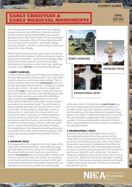
1. Derry ChurChes<br />
1.5miles (2.4 km) north-east of Portaferry, east of the A2 to<br />
Cloughy, approached by a fenced path. Two small ruined<br />
churches stand on a rise in damp surroundings. There is<br />
written evidence of pre-Norman ecclesiastical activity on<br />
the site, associated with St Cumman. A chapel is recorded<br />
on this site in 1302-6. The south church is smaller and<br />
earlier, with antae to east and west, a west door and east<br />
and south windows. The stone was originally bound with<br />
clay, not mortar, and there are cavities for scaffolding<br />
poles and horizontal intramural timbers in the walls.<br />
Some medieval alterations to the door and east window<br />
are marked by contrasting mortar. The north church is<br />
larger, originally also built with clay, not mortar. It had<br />
a south door, an east window and perhaps a tower at<br />
the west end. A small early cross-carved stone is set<br />
in the north church. Excavation in 1962 showed Early<br />
Christian period occupation and a cemetery of stonebuilt<br />
graves under the churches, with an earlier building<br />
of stone and timber, perhaps a church, under the south<br />
church. Conservation following excavation included<br />
the straightening of the dangerously southward leaning<br />
north wall of the smaller church and the replacing of the<br />
original clay bonding material with similarly coloured<br />
mortar.<br />
2. Dromore Cross<br />
At the approach to the bridge over the river Lagan, at the<br />
edge of the cathedral graveyard. Park a little way away<br />
and walk back to the cross, taking care of passing traffic.<br />
The present cathedral must stand on or near the pre-<br />
Norman ecclesiastical site, associated with St Colman, and<br />
the cross survives from this early activity. An inscription<br />
on the shaft records how it was re-erected in 1887, with<br />
much of the shaft and part of the head restored, after use<br />
elsewhere in the town as a market cross and the base<br />
DERRY CHURCHES<br />
DRUMADONNELL CROSS<br />
COUNTY DOWN<br />
(2009)<br />
...............<br />
ECP 004<br />
...............<br />
DROMORE CROSS<br />
of the town stocks. The head has an unperforated ring.<br />
Even in its fragmentary and weathered condition, it is<br />
possible to appreciate the impressive scale of the cross<br />
and the delicacy of the decorated panels worked in hard<br />
granite on its shaft. It is difficult to date this cross, but the<br />
form and decoration suggest that a 9th-century date is<br />
possible. A cross-carved boulder, known as St Colman’s<br />
Pillow, also probably from the early church, is now kept in<br />
the cathedral chancel.<br />
3. DrumaDonnell Cross<br />
Formerly built into the north gable of the school in<br />
Drumadonnell townland, the cross was removed for<br />
safety when the school became derelict in the 1970s and<br />
re-erected, freestanding and under cover, in the Historic<br />
Monuments stone store in Castlewellan Forest Park. For<br />
access contact 028 9054 3004. Not ordinarily accessible<br />
to visitors except by special arrangement. This impressive<br />
granite cross stands in a tall, cubical base. The head is<br />
ringed but unpierced, with a circular motif at the crossing<br />
on each face. Within the distinctive, wide edge mouldings<br />
are panels of interlaced and spiral decoration, partly badly<br />
weathered but partly still clear. This fine cross may date<br />
from the 9th century.
DRUMENA CASHEL LISNAGADE FORT<br />
4. Drumena Cashel anD souterrain<br />
In the northern foothills of the Mournes, 2.5 miles (3.6 km)<br />
south-west of Castlewellan, close to a minor road eastsouth-east<br />
off the A25 to Rathfriland, east of Lough Island<br />
Reavy. This oval cashel, has a wall 2.7 to 3.6 m thick, partly<br />
rebuilt after excavation in 1925-6. The gap to the east may<br />
be the original entrance rather than the narrow modern<br />
approach gap. A number of loose stones in the south part<br />
of the enclosure seem to be remains of foundations for<br />
a house. In the south-west area is a T-shaped souterrain,<br />
its walls are of drystone construction and its roof lintelled<br />
(some lintels are replaced in concrete). The original<br />
entrance to the souterrain was by its south-east arm.<br />
Though not closely datable from excavated finds, this is<br />
a good example of a stone farmstead enclosure of the<br />
early Christian period. There are other cashels in this<br />
rocky upland area. For advice on access, particularly to the<br />
souterrain, contact 028 9054 3037.<br />
5. lisnagaDe Fort<br />
3 miles (4.8 km) south-west of Banbridge and 1.5 miles<br />
(2 km) east-north-east of Scarva, approached across a<br />
field. This is one of Northern Ireland’s most impressive<br />
earthworks, a rath with three massive banks and ditches<br />
(trivallate), partly planted with trees to form a landscape<br />
feature. In 1832 the ditches were apparently cleaned<br />
out, and in places they hold water in wet weather. The<br />
original entrance to the south-east is marked by breaks<br />
in the banks and causeways over the ditches. Some<br />
excavation was done in 1950 but was not published. To<br />
the north, linked by banks and ditches, is a small circular<br />
rath excavated in 1953. This work showed that a square<br />
house was succeeded by a rectangular barn. The entrance<br />
was shown to be on the north side. Part of the line of the<br />
Dane’s Cast linear earthwork runs close by, south of the<br />
fort.<br />
6. lisnavaragh Fort<br />
1/2 mile (0.6 km) west of Lisnagade Fort, in Lisnagade<br />
townland, in the bend of a lane, with a modern house<br />
uncomfortably close to the fort. This impressive oval<br />
enclosure has three surrounding banks and two ditches<br />
(the outermost ditch is probably filled in). The original<br />
entrance through the substantial banks and ditches is<br />
from the south-east. An excavation carried out in 1951<br />
found the stump of one massive gatepost at the entrance.<br />
7. maghera ChurCh anD rounD tower<br />
2 miles (3.2 km) north-north-west of Newcastle in<br />
Carnacavill townland, beside the Church of Ireland parish<br />
church. Gated drive from road leads to car-park at church.<br />
The ruined round tower marks the site of an early church<br />
founded by the 6th-century St Domongart (Donard),<br />
who gave his name to the highest peak in the Mourne<br />
Mountains. The tower stood to its full height until the<br />
early 18th century when it fell in a great storm. It is now<br />
a stump 5.4 m high built of local granite boulders and<br />
shale. The tower was originally constructed with the usual<br />
raised doorway, but this is now a rough gap, without<br />
its dressings. Small-scale excavation in 1965 showed<br />
evidence of Early Christian activity near the tower. In the<br />
oval graveyard behind the parish church (approached<br />
past the church) is the ruin of the medieval parish<br />
church, probably 13th century in date. It has a west door,<br />
unblocked during conservation work in the mid 1970s,<br />
and a small north window. The walls feature voids left<br />
where horizontal intramural timbers have rotted away. At<br />
least two pre-Norman cross-carved stones survive in the<br />
graveyard and others are in storage. Excavation before<br />
the graveyard extension south-west of the present church<br />
showed that the site is enclosed within a deep ditch,<br />
probably extending to form a large circular enclosure.<br />
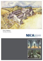
8. nenDrum eCClesiastiCal site<br />
On Mahee Island, reached by twisting lanes and<br />
causeways off the A22 south of Comber. Car-park<br />
at the site and small visitor centre, displaying crosscarved<br />
stones from the site and other exhibits. This is<br />
the best example in Northern Ireland of a pre-Norman<br />
ecclesiastical enclosure with its buildings. Nendrum is<br />
associated with St Mochaoi who died at the end of the<br />
5th century, and is linked with St Patrick in a much later<br />
source. Written notices of Nendrum clergy, including<br />
three bishops, date from as early as the 7th century and it<br />
has been suggested that this was the principal episcopal<br />
church of the Ulstermen at this time. Annal references<br />
continue until a fire in 976, perhaps a Viking raid, when<br />
the head of the church (erenagh) was burned in his house.<br />
In the late 12th century a small Benedictine monastic cell<br />
was founded on the site, but by 1302-6 this was the parish<br />
church, abandoned for Tullynakill on the mainland in the<br />
15th century (see MM005).<br />
LISNAVARAGH FORT<br />
MAGHERA ROUND TOWER
NENDRUM RAHOLP CHURCH<br />
H C Lawlor excavated the site in 1922-4, when enclosure<br />
walls, church and round tower were restored. The glacial<br />
hill is crowned with three concentric irregularly oval<br />
walled enclosures known as cashels. Little is known of<br />
the outer cashel, which is only partly in State Care. In the<br />
middle cashel on the SW side are circular hut platforms,<br />
which excavation suggested were craft workshops,<br />
and a rectangular building known as the ‘schoolhouse’,<br />
also used as a workshop. In the inner cashel were the<br />
most important buildings, including the church with its<br />
graveyard and the base of a round tower north-west of<br />
the church. The west wall of the church was rebuilt in the<br />
1920s, incorporating a reconstructed sundial at the southwest<br />
corner. Finds from the 1920s excavation, including<br />
the well-known bell of Nendrum, are in the Ulster<br />
Museum and Down Museum at Downpatrick. Underwater<br />
archaeological work in the 1990s showed that there is a<br />
stone jetty south-east of the enclosure, now covered by<br />
the lough, and medieval pottery was found close by. The<br />
recent (1990’s) excavation of a sophisticated tide mill on<br />
the shore near the site has shown that the mill was active<br />
in the early 7th century, and this emphasises the early<br />
importance of Nendrum.<br />
9. raholp ChurCh<br />
4 miles (6.4 km) north-east of Downpatrick and about 2<br />
miles (3.2 km) north-east of Saul, off the Saul to Strangford<br />
road, approached across a field to a fenced area. This<br />
small pre-Norman church is associated with Bishop<br />
Tassach and is known locally as St Tassach’s. Early sources<br />
tell us that Tassach administered the last sacrament to<br />
Patrick, but he is not located at Raholp until much later.<br />
The church stands on a marked mound, in places revetted<br />
with drystone-walling and large slabs. A simple rectangle,<br />
the church has a west door with inclining jambs, and an<br />
east window with crosses incised on the straight lintel.<br />
This may date to the 11th century and continued in use<br />
through the Middle Ages. It was listed as a parish church<br />
in the early 14th century. Doors were inserted in the north<br />
and south walls and the small north window was altered.<br />
The early masonry was bound with clay but the later work<br />
was mortared. By the 19th century the church was badly<br />
ruined and in about 1915 F J Bigger carried out extensive<br />
restoration work, including restoring the stone altar. By<br />
the 1980s, when the site came into State Care, it was<br />
again in a bad condition and in the 1990s a conservation<br />
programme was accompanied by excavation. A large slab<br />
east of the church with a socket must be a cross-base, and<br />
there were formerly many small, cross-carved stones in<br />
the church but they have disappeared.<br />
10. rough Fort<br />
1/3 mile (0.5 km) west of Moira at the roadside on Old<br />
Kilmore Road, in Risk townland. This is a well-preserved,<br />
unexcavated rath. The high, roughly circular central area<br />
is slightly dished, surrounded by a deep ditch, a bank<br />
and outer ditch, much silted up and partly occupied by<br />
the road. A causeway on the east side gives access to the<br />
central area. Although recent houses now surround the<br />
fort, we must thank the previous owner who, foreseeing<br />
the prospect of housing in this area, placed it in State Care,<br />
so securing this important and attractive site.<br />
11. st John’s point ChurCh<br />
1.5 miles (2.4 km) south-south-west of Killough, near the<br />
south-east tip of the Lecale peninsula on the road to St<br />
John’s Point lighthouse. This small church, of the 10th<br />
or 11th century, marks the site of an early establishment<br />
associated with Eoan (John) son of Cairland, and in<br />
medieval times it was a chapel. It is an excellent example<br />
of a small, pre-Romanesque church with a lintelled west<br />
door with sloping jambs, antae to east and west and a<br />
south window. This stone church was almost certainly<br />
preceded by a wooden church. Small-scale excavation in<br />
1978 discovered burials under the north wall but no sign<br />
of the claimed radial arrangement of graves around the<br />
church. At the roadside, outside the enclosed area, lies a<br />
holy well and an elongated hollowed stone, probably a<br />
form of grindstone.<br />
12. wooDgrange rath anD tower-house<br />
3.5 miles (5.6 km) south of Crossgar, 1 mile (1.6 km) northeast<br />
of Annadorn Dolmen (see PH007). This is a platform<br />
rath on a hilltop with the remains of a tower-house on its<br />
north-west side. This is a stretch of wall 3.6 m long with<br />
one splayed loop. Nothing is known about its history.<br />
Another rath with an added tower-house can be seen (not<br />
in State Care) at Castleskreen in the Lecale peninsula.<br />
ROUGH FORT ST.JOHN’S POINT
COUNTY DOWN<br />
glossary<br />
Annal: an ancient record of events, especially a yearly<br />
record, usually in chronological order.<br />
Antae: An ornamental column forming the end of a<br />
projecting wall.<br />
Cashel: a circular, drystone, fortified farmstead, common in<br />
upland areas between 400 and 1000 AD<br />
Dolmen: A Neolithic tomb consisting of two or more<br />
upright stones, with a capstone, believed to have been<br />
buried in the earth except for a central opening. Also<br />
called a portal tomb.<br />
Ecclesiastical: relating to the church or clergy.<br />
Episcopal: Relating to Bishops<br />
Intramural: within walls<br />
Jambs: vertical posts that form the side of a door.<br />
Lintel: stones lying across the width of the passage or<br />
door.<br />
Lintelled: having a lintel.<br />
Radial: arranged like the radii of a circle, as with the spokes<br />
of a bicycle wheel<br />
Rath: A fortified farmstead surrounded by circular earth<br />
banks and ditches.<br />
Revetted: Lined with a retaining wall<br />
Souterrain: Underground passages built in Early Christian<br />
raths as a refuge from raiders.<br />
Unperforated: solid, with no holes.<br />
Further reaDing<br />
Mallory and McNeill - The Archeology of Ulster (QUB, 1991)<br />
Colm Donnelly - Living Places (QUB, 1997)<br />
A Hamlin and C Lynn (eds) - Pieces of the Past (HMSO,<br />
1988)<br />
Various- An archaeological survey of County Down (HMSO,<br />
Belfast, 1966).<br />
Our aim is to protect, conserve and promote<br />
the natural and built environment for the<br />
benefit of present and future generations.<br />
Northern Ireland Environment Agency<br />
5-33 Hill Street,<br />
Belfast<br />
BT1 2LA<br />
Tel: 028 9054 3037<br />
www.ni-environment.gov.uk<br />
the monuments and Building record.<br />
The Monuments and Buildings Record (MBR) holds data<br />
on all elements of the built environment in the form of<br />
databases, written, photographic and drawn material.<br />
MBR makes available information on archaeological,<br />
architectural, industrial and maritime sites, as well as<br />
historic gardens and designed landscapes and the<br />
statutory lists of scheduled historic monuments and listed<br />
buildings. For further information visit:<br />
http://www.ni-environment.gov.uk/built/mbr_intro.htm<br />
For advice on access to State Care Monuments contact<br />
NIEA - Regional Operations<br />
Klondyke Building<br />
Gasworks Business Park<br />
Lower Ormeau Road<br />
Belfast<br />
BT7 2JA<br />
Tel: 028 9056 9584<br />
For further information on State Care Monuments contact<br />
the address below