Download the Application for a Construction Site Permit
Download the Application for a Construction Site Permit
Download the Application for a Construction Site Permit

You also want an ePaper? Increase the reach of your titles
YUMPU automatically turns print PDFs into web optimized ePapers that Google loves.
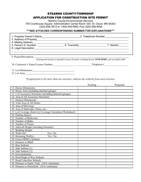
STEARNS COUNTY/TOWNSHIP<br />
APPLICATION FOR CONSTRUCTION SITE PERMIT<br />
Stearns County Environmental Services<br />
705 Courthouse Square, Administration Center Room 343, St. Cloud, MN 56303<br />
(320) 656-3613 or 1-800-450-0852 •Fax (320) 656-6484<br />
***SEE ATTACHED CORRESPONDING NUMBER FOR EXPLANATIONS***<br />
1. Property Owner’s Name___________________________ 2. Telephone Number_________________<br />
3. Address of Property_________________________________________________________________<br />
4. Mailing Address____________________________________________________________________<br />
5. Parcel I.D. Number ___________________ 6. Township____________________ 7. Section ______<br />
8. Legal Description___________________________________________________________________<br />
___________________________________________________________________________________<br />
9. ProjectDescription:___________________________________________________________________________<br />
(If proposed structure is intended to house livestock, including horses, STOP HERE, and see feedlot staff)<br />
10. Contractor’s Name/License Number:______________________________ Telephone #___________________<br />
11. Lot Dimensions:_________________________________<br />
12. Lot Area:_______________________________________<br />
*If application is <strong>for</strong> more than one structure, indicate <strong>the</strong> setbacks from each structure.<br />
13. House Dimensions:<br />
14. House Area (including attached garage):<br />
15. # of Accessory Structures (including detached garage):<br />
16. Area of All Accessory Structures:<br />
17. Deck(s) Dimensions:<br />
18. Total Area of All Decks:<br />
19. Area of Driveway:<br />
20. Area of Sidewalks, Patios, etc.:<br />
21. Lot Coverage (from Lot Coverage Calculation Worksheet):<br />
22. Parking Spaces:<br />
23. Number of Bedrooms:<br />
24. Number of Baths:<br />
25. Number of Floors:<br />
26. Sidewall Height (including Dormers):<br />
27. Building Height:<br />
28. Walk Out? Yes / No<br />
29. Retaining Wall(s): Yes / No<br />
30. Front (OHWL) Setback:<br />
31. Distance to Bluff:<br />
32. Rear Setback:<br />
33. Side Setback (1):<br />
34. Side Setback (2):<br />
35. Encroachments:<br />
36. Road Right of Way Setback:<br />
37. Road Centerline Setback:<br />
38. Distance to Septic Tank: (10 ft. minimum)<br />
39. Distance to Drainfield: (20 ft. minimum)<br />
Existing Proposed
40. Distance to Feedlots:<br />
41. Distance to Wetlands:<br />
42. Project Will Disturb More Than One Acre (43560 ft 2 )?<br />
***ANY PROJECT CHANGES MADE AFTER RECEIVING YOUR PERMIT MUST BE***<br />
DOCUMENTED ON THE ORIGINAL PERMIT OR AFTER-THE-FACT FEES MAY APPLY.<br />
43. For Agricultural <strong>Construction</strong> - If this structure is intended to house livestock, including horses, a feedlot<br />
permit shall be required according to Section 6.7.4 of <strong>the</strong> Stearns County Zoning Ordinance (# 439).<br />
44. For Non-Agricultural <strong>Construction</strong> in Agriculturally Zoned Areas - If this non-agricultural structure is to be<br />
constructed within an agriculturally zoned area, it is important to realize that at times, <strong>the</strong>re may be: odor from<br />
livestock operations and manure applications; noise from farm equipment; and occasional soil, mud or manure left<br />
on roads throughout <strong>the</strong> year.<br />
45. Agreement: I hereby acknowledge that I have read this application and state that all in<strong>for</strong>mation is true and correct to<br />
<strong>the</strong> best of my knowledge. I fur<strong>the</strong>r agree that all work per<strong>for</strong>med will be in accordance with approved plans, specifications<br />
and conditions, and to abide by all of <strong>the</strong> ordinances of Stearns County regarding actions taken pursuant to this application.<br />
Any plans submitted herewith shall become part of <strong>the</strong> permit application. This application shall not be considered a complete<br />
application until <strong>the</strong> applicant has staked <strong>the</strong> proposed building site. Incomplete applications shall expire six (6) months<br />
from <strong>the</strong> date of application. It is <strong>the</strong> responsibility of <strong>the</strong> applicant to obtain any o<strong>the</strong>r necessary permits from <strong>the</strong>ir<br />
Township. Signature of this application authorizes Environmental Services Staff to enter upon <strong>the</strong> property to per<strong>for</strong>m needed<br />
inspections. Entry may be without prior notice.<br />
Signature Date<br />
46. Township Approval<br />
A Valid Township signature may be required prior to Stearns County reviewing permit application.<br />
<strong>Permit</strong> Conditions:_______________________________________________________________________________________<br />
______________________________________________________________________________________________________<br />
__________________________________________________________ Date:_____________________________<br />
Township Signature<br />
FEE:_____________ (NON-REFUNDABLE)<br />
Receipt Number:______________________________
Parcel #: _______________________<br />
<strong>Site</strong> Plan<br />
Indicate in <strong>the</strong> space below <strong>the</strong> following:<br />
1. Dimensions of existing and proposed structures.<br />
2. Setbacks from: OHWL (ordinary high water level), front yard, rear yard, side yard, encroachments, road rightof-way,<br />
centerline, bluff.
WETLAND ADVISORY<br />
Will your proposed project result in impacts to wetlands?<br />
A wetland is a landscape feature transitional between terrestrial and aquatic systems where <strong>the</strong><br />
water table is usually at or near <strong>the</strong> surface of <strong>the</strong> land or is covered by shallow water. The<br />
presence of surface inundation or saturation in a wetland results in a prevalence of wetland<br />
vegetation and specific characteristics developing in <strong>the</strong> soil. Wetlands may also be referred to as<br />
swamps, bogs, sloughs, nuisance-wet spots, low ground and o<strong>the</strong>rs.<br />
There are eight types of wetlands in Minnesota:<br />
Type 1 - Seasonally flooded basins or flats. Soil is covered with water or waterlogged during seasonal<br />
periods, but is usually well drained during <strong>the</strong> growing season.<br />
Type 2 - Wet meadows. Soil is usually without standing water most of <strong>the</strong> growing season but is<br />
waterlogged within a few inches of <strong>the</strong> surface.<br />
Type 3 - Shallow marshes. Soils, which are usually waterlogged during <strong>the</strong> growing season and are<br />
often covered with up to 6 inches of water. Many have cattails and bulrushes and small open water<br />
areas.<br />
Type 4 - Deep marshes. Soils, which are usually covered with 6-inches to 3-feet of water during <strong>the</strong><br />
growing season, Many have cattails and bulrushes and small open water areas.<br />
Type 5 - Open water wetlands. Shallow water ponds and reservoirs with water 3 to 10 feet deep.<br />
Type 6 - Shrub swamps. Soil is usually waterlogged during <strong>the</strong> growing season and is often covered<br />
with as much as 6-inches of water.<br />
Type 7 - Wooded swamps. Soil is waterlogged at least to within a few inches of <strong>the</strong> surface during <strong>the</strong><br />
growing season with as much as one foot of water. Occur mostly along sluggish streams and flood<br />
plains.<br />
Type 8 – Bogs. Soil is usually waterlogged and supports a spongy covering of mosses.<br />
Stearns County Environmental Services reminds you that State and Federal Law prohibits <strong>the</strong> draining or<br />
filling of wetlands, unless specifically approved or exempted by <strong>the</strong> appropriate authorities. Stearns<br />
County Environmental Services administers <strong>the</strong> Minnesota Wetland Conservation Act (WCA) and <strong>the</strong><br />
U.S. Army Corps of Engineers administers Section 404 of <strong>the</strong> Clean Waters Act.<br />
Filling or draining a wetland in violation of <strong>the</strong> Minnesota WCA or <strong>the</strong> Clean Waters Act can result in<br />
criminal penalties and fines. If a violation exists on a property, a restoration order may be issued that<br />
requires <strong>the</strong> property owner to restore <strong>the</strong> impacted wetland to its <strong>for</strong>mer condition (this may include <strong>the</strong><br />
removal of buildings and all fill material in <strong>the</strong> impact area.<br />
As <strong>the</strong> applicant <strong>for</strong> this permit or project, you are responsible <strong>for</strong> determining whe<strong>the</strong>r any<br />
wetlands will be affected by this proposed project. If you believe <strong>the</strong>re is potential <strong>for</strong> wetland<br />
impacts associated with your project, you are advised to contact Stearns County Environmental<br />
Services be<strong>for</strong>e commencing any such work.
Parcel #:_________________ Lot Coverage Calculation Worksheet Date:_________________<br />
Lot coverage is limited to 25% of <strong>the</strong> total lot. The total may not be larger than <strong>the</strong> maximum coverage<br />
calculation below!! Please be advised that if you are over <strong>the</strong> lot coverage allowance, you must reduce your<br />
coverage or apply <strong>for</strong> a variance be<strong>for</strong>e your proposed project will be permitted.<br />
Instructions:<br />
Please calculate out all that apply to your situation. If an item does not apply, please leave it blank.<br />
Length (ft) X Width(ft) = Total (ft²)<br />
Proposed Structure(s)<br />
(ft) X (ft) = (ft²)<br />
(ft) X (ft) = (ft²)<br />
(ft) X (ft) = (ft²)<br />
Existing Structure(s)<br />
House & Attached Garage (ft) X (ft) = (ft²)<br />
House Only ______(ft) X (ft) = (ft²)<br />
______(ft) X (ft) = (ft²)<br />
______(ft) X (ft) = (ft²)<br />
Attached Garage Only (ft) X (ft) = (ft²)<br />
Detached Garage (ft) X (ft) = (ft²)<br />
Accessory Structures (ft) X (ft) = (ft²)<br />
*storage sheds, pole sheds, (ft) X (ft) = (ft²)<br />
utility bldg., dog kennels, (ft) X (ft) = (ft²)<br />
water orientated structures (ft) X (ft) = (ft²)<br />
boat house, green house (ft) X (ft) = (ft²)<br />
Deck(s) (ft) X (ft) = (ft²)<br />
______(ft) X (ft) = (ft²)<br />
Driveway, Parking Areas, Aprons, (ft) X (ft) = (ft²)<br />
Boat Ramp (*asphalt, cement, gravel) (ft) X (ft) = (ft²)<br />
(ft) X (ft) = (ft²)<br />
(ft) X (ft) = (ft²)<br />
Sidewalk, Patio, Paving Stones (ft) X (ft) = (ft²)<br />
(ft) X (ft) = (ft²)<br />
(ft) X (ft) = (ft²)<br />
Landscaping (plastic under rocks) (ft) X (ft) = (ft²)<br />
(ft) X (ft) = (ft²)<br />
O<strong>the</strong>r (ft) X (ft) = (ft²)<br />
(ft) X (ft) = (ft²)<br />
Total = (ft²)<br />
X 0.25 =<br />
Lot Area (ft²) Maximum coverage allowed (ft²)<br />
Lot Area: Calculate lot area by multiplying <strong>the</strong> length of <strong>the</strong> lot times <strong>the</strong> width. However, if <strong>the</strong> length and width<br />
vary, as in <strong>the</strong> example, take <strong>the</strong> average length and width:<br />
226’<br />
175’<br />
186’<br />
250’<br />
Average Width: 175’ + 186’= 361/2= 181’<br />
Average Length: 226’ + 250’= 476/2= 238’<br />
Lot Size: (W) 181’ * (L) 238’= 43,078 square feet<br />
Lot Area: 43,078 square feet<br />
1 Acre = 43,560 ft²<br />
Please show lot area calculations!
PERMIT APPLICATION KEY<br />
1. Property Owner’s Name: Print name of property owner. <strong>Application</strong>s will only be accepted from property owner or<br />
authorized agent.<br />
2. Telephone Number: Print both home and work telephone numbers.<br />
3. Address of Property: Indicate property address. If you do not have a property address, leave blank and staff will assign an<br />
address.<br />
4. Mailing Address: If property address is different from your mailing address, please indicate.<br />
5. Parcel I.D. Number: Parcel I.D. number may be obtained from your property tax statement. It is located in <strong>the</strong> upper righthand<br />
corner. This number starts with <strong>the</strong> letter “R” followed by a ten digit number (i.e. R xx.xxxxx.xxx).<br />
6. Township: Indicate township name.<br />
7. Section: Section number may be obtained from tax statement, deed, or abstract.<br />
8. Legal Description: Legal description may be obtained from tax statement, deed, or abstract. For example, Lot 2 Block 1,<br />
Blank Addition.<br />
9. Project Description: Describe project. Include decks or accessory structures that are proposed to be built under this permit.<br />
<strong>Permit</strong>s are valid <strong>for</strong> 1 year from date of issuance.<br />
10. Contractor’s Name/License Number: Indicate contractor’s name and license number. The State of Minnesota requires that<br />
all residential building contractors, remodelers, and roofers obtain a state license unless <strong>the</strong>y qualify <strong>for</strong> a specific<br />
exemption from <strong>the</strong> licensing requirements. If you will be <strong>the</strong> general contractor, you are exempt from this requirement<br />
but are required to sign <strong>the</strong> attached waiver entitled “Building <strong>Permit</strong> Applicant: Property Owner”.<br />
STAKE PROPOSED STRUCTURES OR ADDITIONS PRIOR TO<br />
SUBMITTING PERMIT APPLICATION.<br />
THE FOLLOWING INFORMATION MUST BE INCLUDED ON SITE SKETCH FOR ALL PROPOSED AND<br />
EXISITING STRUCTURES.<br />
Dimensions<br />
11. Lot Dimensions: Length and width of <strong>the</strong> lot.<br />
12. Lot Area: Calculate lot area by multiplying <strong>the</strong> length of <strong>the</strong> lot times <strong>the</strong> width. However, if <strong>the</strong> length and width vary, as<br />
in <strong>the</strong> example, take <strong>the</strong> average length and width:<br />
226’<br />
175’<br />
186’<br />
250’<br />
Average Width: 175’ + 186’= 361/2= 181’<br />
Average Length: 226’ + 250’= 476/2= 238’<br />
Lot Size: (W) 181’ * (L) 238’= 43,078 square feet<br />
Lot Area: 43,078 square feet<br />
13. House Dimensions: Length and width of <strong>the</strong> house/principal structure. A principal structure is any structure that is not an<br />
accessory structure. For example, a residential dwelling is a principal structure. Only one house/principal structure is<br />
allowed on a parcel.<br />
14. House Area: Calculate <strong>the</strong> area of <strong>the</strong> proposed or existing house/principal structure by multiplying <strong>the</strong> length times <strong>the</strong><br />
width. Include area of attached garage if applicable.<br />
15. Number of Accessory Structure and Dimensions: Indicate number of structures. Include length and width of proposed and<br />
existing accessory structure(s). An accessory structure is a structure on <strong>the</strong> same lot with, and incidental and subordinate<br />
to, <strong>the</strong> principal structure. For example, a detached building (garage) is an accessory structure.
16. Area of Accessory Structures: Calculate <strong>the</strong> area of proposed and existing accessory structures by multiplying <strong>the</strong> length<br />
times <strong>the</strong> width. Include area of detached garage if applicable.<br />
17. Deck(s) Dimensions: Indicate dimensions of all decks.<br />
18. Total Area of All Decks: Calculate area <strong>for</strong> each deck by multiplying <strong>the</strong> length times <strong>the</strong> width and add toge<strong>the</strong>r.<br />
19. Area of Driveway: Measure driveway length from <strong>the</strong> road right of way to <strong>the</strong> beginning of <strong>the</strong> driveway. Measure<br />
driveway width by measuring <strong>the</strong> width at <strong>the</strong> beginning, at <strong>the</strong> right of way, at <strong>the</strong> middle, and ¼ of <strong>the</strong> way from each<br />
end. Add <strong>the</strong> 5 measurements toge<strong>the</strong>r and divide by 5 to get <strong>the</strong> average. Using <strong>the</strong> average, multiply by <strong>the</strong> driveway<br />
length and this will give you <strong>the</strong> area of <strong>the</strong> driveway.<br />
20. Area of Sidewalks, Patios, Etc: Calculate area <strong>for</strong> each by multiplying <strong>the</strong> length times <strong>the</strong> width and add toge<strong>the</strong>r.<br />
21. Lot Coverage: Lot coverage is determined by dividing <strong>the</strong> area of a lot that is covered by impervious surfaces by <strong>the</strong> lot<br />
area. Impervious surfaces are surfaces that are highly resistant to infiltration by water. They include but are not limited to<br />
<strong>the</strong> following: houses, garages, driveways, sidewalks, decks, patios, parking pads or lots, landscaped areas, etc.<br />
22. Parking Spaces: Parking space standards need to be met if <strong>the</strong> permit application is <strong>for</strong> a provisional use. The number of<br />
required off-street parking spaces is based on type of use. For example, eating and drinking establishments must provide<br />
one space <strong>for</strong> each three seats, based on maximum design capacity. If applicable, indicate parking space allocation on site<br />
sketch.<br />
23. Number of Bedrooms: Indicate number of bedrooms.<br />
24. Number of Bathrooms: Indicate number of bathrooms.<br />
25. Number of Floors: Indicate number of floors and if <strong>the</strong> structure has a walkout basement and if retaining walls are to be<br />
used. For retaining walls, indicate proposed location, length, and height on site plan.<br />
26. Sidewall Height: Indicate sidewall height.<br />
27. Building Height: Indicate building height. Height is defined as <strong>the</strong> vertical distance between <strong>the</strong> highest adjoining ground<br />
level at <strong>the</strong> building or ten feet above <strong>the</strong> lowest ground level, whichever is lower, and <strong>the</strong> highest point of a flat roof or<br />
height of <strong>the</strong> top of <strong>the</strong> highest gable of a pitched or hipped roof.<br />
28. Walkout: Indicate if <strong>the</strong> structure has a walkout basement.<br />
29. Retaining Wall: Indicate <strong>the</strong> proposed location, length, and height on site plan.<br />
30. Front (OHWL) Setback: On riparian lots, <strong>the</strong> front yard setback is measured from <strong>the</strong> OHWL (ordinary high water level).<br />
A riparian lot borders a waterbody. On non-riparian lots, <strong>the</strong> front yard setback is measured from <strong>the</strong> road right-of-way or<br />
centerline, whichever is more restrictive. See #36 and #37 <strong>for</strong> explanation on how to determine <strong>the</strong> road right-of-way or<br />
centerline setback.<br />
31. Distance To Bluff: A bluff is defined as a topographic feature such as a hill, cliff, or embankment that rises at least 25 feet<br />
above <strong>the</strong> ordinary high water level and <strong>the</strong> grade of <strong>the</strong> slope from <strong>the</strong> toe of <strong>the</strong> bluff to a point 25 feet or more above <strong>the</strong><br />
ordinary high water level and averages 30% or greater. The slope must be located in shoreland and drain toward <strong>the</strong> water<br />
body. Environmental Services staff can make a bluff determination.<br />
32. Rear Setback: On riparian lots, <strong>the</strong> rear yard setback is measured from <strong>the</strong> road right-of-way or centerline, whichever is<br />
more restrictive. On non-riparian lots, <strong>the</strong> rear setback is measured from <strong>the</strong> rear lot line. See #36 and #37 <strong>for</strong> explanation<br />
on how to determine <strong>the</strong> road right-of-way or centerline setback.<br />
33. & 34. Side Setbacks: The side yard setback is measured from both side lot lines.<br />
35. Encroachments: The following shall be permitted encroachments into setback requirements: 1) Flues, roof overhangs,<br />
awnings, bay windows and chimneys up to 2 feet in width; 2) Steps, sidewalks, stoops, and exposed wheelchair ramps up<br />
to 4 feet in width; 3) Recreational playground equipment <strong>for</strong> private use. Indicate any encroachments on site sketch.
36. Road Right-of-Way Setback: In some areas <strong>the</strong> road right-of-way is marked with a ROW marker. If a survey has been<br />
completed and your property lines have been marked with survey pins, <strong>the</strong> pin located nearest <strong>the</strong> road would indicate <strong>the</strong><br />
right-of-way. If you still cannot locate <strong>the</strong> right-of-way: 1) <strong>for</strong> township roads- contact your township and ask <strong>the</strong>m to<br />
determine ROW; 2) For County roads-contact Stearns County Public Works at 320-255-6180. Measure from this point to<br />
<strong>the</strong> closest point of <strong>the</strong> proposed structure or addition. On riparian lots, <strong>the</strong> road right-of-way or centerline setback,<br />
whichever is more restrictive, is also <strong>the</strong> rear yard setback. On non-riparian lots, <strong>the</strong> road right-of-way or centerline<br />
setback, whichever is more restrictive is also <strong>the</strong> front yard setback. Duplicate <strong>the</strong>se numbers in <strong>the</strong> appropriate section.<br />
37. Road Centerline Setback: Measure from <strong>the</strong> centerline of <strong>the</strong> road to <strong>the</strong> closest point of <strong>the</strong> proposed structure or addition.<br />
The more restrictive setback from <strong>the</strong> road right-of-way or centerline shall apply.<br />
38. Distance To Septic Tank: Indicate distance from septic tank to proposed structure(s).<br />
39. Distance To Drainfield: Indicate distance from drainfield to proposed structure(s).<br />
40. Distance To Feedlots: If permit application is <strong>for</strong> a residential dwelling unit or an addition to a residential dwelling unit,<br />
indicate <strong>the</strong> approximate distance from nearest feedlots. Stearns County Feedlot staff will be verifying that all setbacks are<br />
met during <strong>the</strong> application review process.<br />
41. Wetlands: Indicate distance from wetland to proposed structure(s). Caution: standing water is not always present in<br />
wetlands. SEE WETLAND ADVISORY LITERATURE.<br />
42. Even though disturbance may be less than 1 acre, if your parcel is part of a newer or larger subdivision, each individual lot<br />
may be required to obtain a National Pollutant Discharge Elimination System (NPDES) <strong>Permit</strong> through <strong>the</strong> Minnesota<br />
Pollution Control Agency.<br />
43. Agricultural <strong>Construction</strong>: General in<strong>for</strong>mation <strong>for</strong> housing animals.<br />
44. Non-Agricultural <strong>Construction</strong> in Agriculturally Zoned Areas: General in<strong>for</strong>mation.<br />
45. Agreement: Please read agreement and date & sign application.<br />
46. Township Approval: A valid township signature may be required prior to Stearns County reviewing any permit<br />
application.