38. Mullaghmore Mini-Plan - Sligo County Council
38. Mullaghmore Mini-Plan - Sligo County Council
38. Mullaghmore Mini-Plan - Sligo County Council

You also want an ePaper? Increase the reach of your titles
YUMPU automatically turns print PDFs into web optimized ePapers that Google loves.
<strong>38.</strong> <strong>Mullaghmore</strong> <strong>Mini</strong>-<strong>Plan</strong><br />
Village Profile<br />
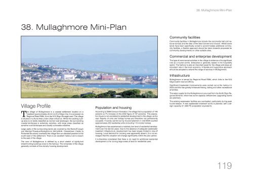
The village of <strong>Mullaghmore</strong> is a coastal settlement located on a<br />
headland approximately 25 km north of <strong>Sligo</strong> City. It is accessed via<br />
Regional Road R284, from the N15 <strong>Sligo</strong>-Donegal road. The village<br />
is situated in a Rural Area under Urban Influence. Whilst the existing builtup<br />
area is on lands classified as normal rural landscape, the surrounding<br />
coastal landscape is extremely sensitive, with large areas classified as<br />
sensitive rural landscape and visually vulnerable coastline.<br />
Large parts of the surrounding lands are covered by the Bunduff Lough<br />
and Machair/Trawalua/<strong>Mullaghmore</strong> SAC/pNHA. Classiebawn Castle (a<br />
Protected Structure) overlooks the village form an elevated position to the<br />
south-west of the settlement. There is an excellent harbour and a beach<br />
to the east of the village.<br />
The core of <strong>Mullaghmore</strong> is defined by a short stretch of tightly-knit<br />
street-fronting buildings close to the harbour. The remainder of the village<br />
generally consists of low-density housing development.<br />
Population and housing<br />
According to 2006 Census information, the village had a population of 146<br />
persons (a 7% increase on the 2002 figure of 137 persons). This population<br />
figure is not correlated to residential development in the village, as the<br />
vast majority of units are holiday homes and therefore not permanently<br />
occupied. A survey carried out by <strong>Council</strong> planners in mid-2009 counted<br />
approximately 250 residential units (including 115 mobile homes).<br />
<strong>Mullaghmore</strong> has experienced a relatively low level of residential development<br />
over the last ten years. Due to the absence of adequate wastewater<br />
treatment infrastructure, development has been largely limited to one-off<br />
housing. Local demand for housing was apparently absent. It is not envisaged<br />
that this situation will change significantly within the plan period.<br />
It is therefore considered that there is no need for additional residential<br />
development or for zoning large areas of land for residential uses.<br />
Community facilities<br />
<strong>38.</strong> <strong>Mullaghmore</strong> <strong>Mini</strong>-<strong>Plan</strong><br />
Community facilities in <strong>Mullaghmore</strong> include the community hall (old national<br />
school) and the Star of the Sea Convent and Church. Whilst some<br />
lands have been specifically zoned to accommodate additional community<br />
facilities, a flexible approach should be taken towards proposals for<br />
community developments on other suitable sites.<br />
Commercial and enterprise development<br />
The type of commercial activities in the village is evidence of its significant<br />
role as a tourist centre. Enterprise is generally based in the hospitality<br />
sector. The harbour is also an important asset for the village and plays an<br />
important role in the local economy. A flexible and supportive approach<br />
should be adopted to extend the range of services in <strong>Mullaghmore</strong>.<br />
Infrastructure<br />
<strong>Mullaghmore</strong> is served by Regional Road R284, which links to the N15<br />
<strong>Sligo</strong>-Dublin road at Cliffony.<br />
Significant breakwater improvements were carried out at the harbour in<br />
2003 and this has greatly enhanced fishing, sailing and other recreational<br />
amenities.<br />
The water supply for the <strong>Mullaghmore</strong> is sourced from the North <strong>Sligo</strong> Regional<br />
Scheme, which has some capacity deficiencies (upgrading works<br />
are planned).<br />
The existing wastewater facilities are overloaded, particularly during peak<br />
tourist season. A new wastewater treatment works is planned, with a design<br />
capacity of 1,600 PE (population equivalent).<br />
119
<strong>38.</strong> <strong>Mullaghmore</strong> <strong>Mini</strong>-<strong>Plan</strong><br />
Objectives<br />
It is an objective of <strong>Sligo</strong> <strong>County</strong> <strong>Council</strong> to:<br />
<strong>38.</strong>1 Natural heritage and open space<br />
A. Encourage the protection and enhancement of the conservation value<br />
of Bunduff Lough and Machair / Trawalua / <strong>Mullaghmore</strong> SAC/pNHA.<br />
B. Encourage improved access to the seashore by providing walkways<br />
and open space (as indicated on the Objectives Map) and by requiring<br />
the provision of such facilities in conjunction with any development of<br />
adjoining lands.<br />
C. Ensure that development is carried out in such a way as to capitalise<br />
upon and protect public scenic views of the Atlantic Ocean, Donegal<br />
Bay, the Dartry Mountain Range and Knocknarea, particularly from the<br />
designated scenic routes in and around the village.<br />
D. Ensure the ongoing preservation of the existing trees on the Tree Preservation<br />
Order site (see the Objectives Map). These trees shall be preserved<br />
in accordance with the terms of the Tree Preservation Order<br />
that covers this area.<br />
E. Generally retain land between the development limit and the coastline<br />
free from development in order to ensure that visually vulnerable<br />
coastal lands are protected and to assist in the conservation of adjacent<br />
designated sites.<br />
<strong>38.</strong>2 Built heritage<br />
A. Seek the protection and conservation of the following Protected<br />
Structures:<br />
RPS-146 <strong>Mullaghmore</strong> Harbour<br />
RPS-147 Star of the Sea Convent & Church<br />
RPS-148 McGloin’s (former shop)<br />
RPS-149 <strong>Mullaghmore</strong> National School (former)<br />
RPS-150 Classiebawn Watchtower<br />
RPS-151 House at Sand Hill, south of <strong>Mullaghmore</strong><br />
RPS-199 Classie Bawn Castle<br />
RPS-200 Classie Bawn Gate Lodge<br />
RPS-201 White House, <strong>Mullaghmore</strong><br />
<strong>38.</strong>3 Circulation and parking<br />
A. Support the provision and improvement of pedestrian links between<br />
the village and surrounding natural amenities (as indicated on objectives<br />
map). The provision of such links will also be required in conjunction<br />
with any development of adjoining lands.<br />
B. Improve traffic calming measures along the regional road R279, particularly<br />
along the south-western approach to the village.<br />
C. Ensure that additional development is not permitted in existing residential<br />
schemes where the roads have not been completed to an adequate<br />
standard.<br />
120<br />
D. In cases where on-site car-parking requirements cannot reasonably<br />
be provided, a shortfall may be accepted, subject to satisfactory alternative<br />
proposals such as the payment of a financial contribution or the<br />
provision of parking at a suitable alternative location.<br />
<strong>38.</strong>4 Village-centre mixed-use zone<br />
A. Encourage an appropriate mix of residential and commercial uses<br />
within the village centre in order to protect the vitality and viability of<br />
this area. In order to facilitate development at this location, car-parking<br />
policy will be applied in accordance with point <strong>38.</strong>3 D above.<br />
B. Ensure that new development within the village centre is appropriately<br />
scaled and designed to be in keeping with the character of existing<br />
development.<br />
C. Except in the case of site VC-1 (as identified on objectives map) and<br />
other sites which already contain buildings higher than two storeys,<br />
development / redevelopment proposals within the village centre<br />
should be limited to two storeys in height. The development of the<br />
village centre should incorporate an appropriate feathering towards<br />
lower building heights as development progresses northwards.<br />
D. Any redevelopment of the Beach Hotel building (on site VC-1) shall<br />
include the retention of the building’s front façade.<br />
E. In order to retain the character and rhythm of the existing streetscape,<br />
encourage the retention and refurbishment of existing properties rather<br />
than demolition and reconstruction.<br />
F. Encourage the redevelopment of the site to the north of the Pier Head<br />
Hotel with more appropriate village-centre-type uses. Any development<br />
proposal on this site should:<br />
create suitable streetscape along the adjoining public road and<br />
present an aspect onto Donegal Bay;<br />
be designed to a high standard, reflecting the prominent position<br />
of the site at the centre of the village.<br />
<strong>38.</strong>5 Community facilities<br />
A. On lands zoned for community facilities, encourage the development<br />
of a multi-purpose community building, with shared use of services<br />
and resources.<br />
<strong>38.</strong>6 Residential development<br />
A. Apart from within the village centre area, new residential development<br />
will be encouraged at relatively low densities, in keeping with surrounding<br />
development.<br />
B. New residential development should be sited and designed to ensure<br />
that it is satisfactorily absorbed into the landscape. The design should<br />
respond to the existing site characteristics without the need for excessive<br />
excavation or landscaping. Ideally, development should take<br />
place in an organic manner and should avoid the linear patterns which<br />
are evident in some parts of the village.<br />
C. Residential development should generally be restricted to single-storey<br />
or low-profile dormer height. However, each case will be assessed<br />
on its merits at planning application stage and the determining factor<br />
will be the capacity of the particular site/location to absorb the proposed<br />
development.<br />
D. Coordinated development of residential lands will be encouraged, including<br />
shared use of access roads, entrances etc. Whilst individual<br />
houses will be permitted, such proposal should not compromise the<br />
future development of surrounding lands.<br />
<strong>38.</strong>7 Business and enterprise<br />
A. Encourage the maintenance and enhancement of existing tourism /<br />
recreational assets such as <strong>Mullaghmore</strong> Sailing Club.<br />
B. Support the continued development of the harbour and associated<br />
facilities.<br />
C. Facilitate tourism-based developments within the village centre area.<br />
D. The Zoning Map identifies a large area which is reserved for the provision<br />
of tourism-related uses. Residential development (apart from<br />
short-term accommodation such as hotel, hostel etc) will not be permitted<br />
on these lands. Any development proposal for these lands<br />
should:<br />
be based on a masterplan coordinating the development of individual<br />
landholdings;<br />
provide an appropriate aspect when viewed from the surrounding<br />
public roads and other main vantage points, including the N15<br />
designated scenic route;<br />
be sited and designed to a high standard, having appropriate<br />
regard to the topography and protecting scenic views towards<br />
Donegal Bay and the Atlantic Ocean.<br />
<strong>38.</strong>8 Wastewater treatment<br />
A. Reserve land for the provision of a new wastewater treatment plant<br />
with a design capacity of 1,600 PE (population equivalent).<br />
B. No additional multiple-unit developments shall be permitted to connect<br />
to the existing public wastewater system until the new treatment<br />
plant is completed and operational. In the absence of treatment capacity,<br />
on-site wastewater treatment proposals for individual developments<br />
will be considered, subject to appropriate design, site assessment<br />
etc. Communal systems will not be permitted in any case.<br />
C. Upon completion of the new WWTP, allow additional development up<br />
to a limit of 1,600 PE (population equivalent). Notwithstanding this<br />
available capacity, residential development shall be permitted only at<br />
a rate that is consistent with the Core Strategy and the Settlement<br />
Structure (see Chapter 3 of this <strong>Plan</strong>).<br />
D. Carry out appropriate landscaping and screening works in conjunction<br />
with the development of the WWTP.<br />
E. A buffer zone shall apply in the vicinity of the WWTP site. Development<br />
within this zone may be restricted or prohibited in the interests of<br />
public health and/or the protection of residential amenities. The extent<br />
of development restrictions in each case will be assessed at planning<br />
application stage.
121
122
123
124