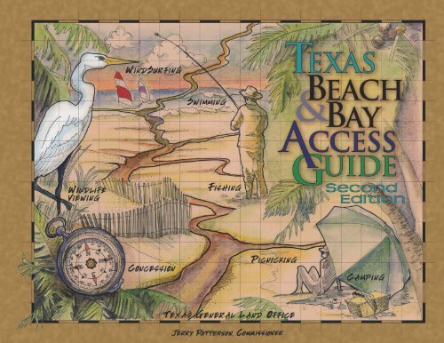
Texas Beach and Bay Access Guide. - Texas General Land Office
Texas Beach and Bay Access Guide. - Texas General Land Office
Texas Beach and Bay Access Guide. - Texas General Land Office

Create successful ePaper yourself
Turn your PDF publications into a flip-book with our unique Google optimized e-Paper software.
The <strong>Texas</strong> Gulf Coast<br />
The <strong>Texas</strong> Gulf Coast consists of cordgrass marshes, which support a rich array of marine life <strong>and</strong><br />
provide wintering grounds for birds, <strong>and</strong> scattered coastal tallgrass <strong>and</strong> mid-grass prairies. The<br />
annual rainfall for the <strong>Texas</strong> Coast ranges from 25 to 55 inches <strong>and</strong> supports morning glories, sea<br />
ox-eyes, <strong>and</strong> beach evening primroses.<br />
Click on a region of the <strong>Texas</strong> coast<br />
<strong>Texas</strong> <strong>Beach</strong> & <strong>Bay</strong><br />
<strong>Access</strong> <strong>Guide</strong><br />
Second Edition<br />
<strong>Texas</strong> <strong>General</strong> L<strong>and</strong> <strong>Office</strong><br />
Jerry Patterson, Commissioner<br />
The <strong>Texas</strong> <strong>General</strong> L<strong>and</strong> <strong>Office</strong> makes no representations or warranties regarding the accuracy or completeness of<br />
the information depicted on these maps, or the data from which it was produced. These maps are NOT suitable for<br />
navigational purposes <strong>and</strong> do not purport to depict or establish boundaries between private <strong>and</strong> public l<strong>and</strong>.
1<br />
3<br />
7<br />
21<br />
79<br />
96<br />
128<br />
139<br />
143<br />
147<br />
Contents<br />
I. Introduction<br />
II. How to Use This <strong>Guide</strong><br />
III. <strong>Beach</strong> <strong>and</strong> <strong>Bay</strong> Public <strong>Access</strong> Sites<br />
A. Southeast <strong>Texas</strong><br />
(Jefferson <strong>and</strong> Orange Counties)<br />
1. Map<br />
2. Area information<br />
3. Activities/Facilities<br />
B. Houston-Galveston<br />
(Brazoria, Chambers, Galveston, Harris, <strong>and</strong> Matagorda Counties)<br />
1. Map<br />
2. Area Information<br />
3. Activities/Facilities<br />
C. Golden Crescent<br />
(Calhoun, Jackson <strong>and</strong> Victoria Counties)<br />
1. Map<br />
2. Area Information<br />
3. Activities/Facilities<br />
D. Coastal Bend<br />
(Aransas, Kenedy, Kleberg, Nueces, Refugio <strong>and</strong> San Patricio Counties)<br />
1. Map<br />
2. Area Information<br />
3. Activities/Facilities<br />
E. Lower Rio Gr<strong>and</strong>e Valley<br />
(Cameron <strong>and</strong> Willacy Counties)<br />
1. Map<br />
2. Area Information<br />
3. Activities/Facilities<br />
IV. National Wildlife Refuges<br />
V. Wildlife Management Areas<br />
VI. Chambers of Commerce <strong>and</strong> Visitor Centers
Introduction<br />
It’s no wonder that coastal communities are the most densely populated <strong>and</strong> fastest growing areas<br />
in the country. The opportunities <strong>and</strong> resources that originally lured Native Americans <strong>and</strong> settlers<br />
continue to attract people to the coast today. Throughout the year, tourists travel to the shore to<br />
enjoy recreational activities <strong>and</strong> visit locales with relaxed surroundings. Coastal residents <strong>and</strong><br />
tourists seek out beaches <strong>and</strong> bays for fishing, swimming, wildlife viewing, picnicking, camping,<br />
boating, <strong>and</strong> other activities. Tourism is big business in <strong>Texas</strong>, <strong>and</strong> coastal communities rely on their<br />
beaches <strong>and</strong> bays to attract tourists, who spend billions of dollars each year. As a result, ensuring<br />
public access to the shoreline is of central importance to a coastal community’s ecotourism<br />
economy.<br />
With a diversity of plants, wildlife, <strong>and</strong> ecoregions along its 367 miles of Gulf shoreline <strong>and</strong> 3,300<br />
miles of bay shoreline, the <strong>Texas</strong> coast has plentiful natural resources. <strong>Texas</strong> coastal communities<br />
continue a coastal historic heritage with an active economy. Whether the coastal traveler<br />
is interested in fishing, birding, beachcombing, or simply sight-seeing, the <strong>Texas</strong> coast has something<br />
to offer everyone.<br />
<strong>Texas</strong> Coastal Management Program<br />
In 1991, the <strong>Texas</strong> Legislature passed the Coastal Coordination Act, establishing a comprehensive<br />
state coastal management program. This act paved the way to more effective <strong>and</strong> efficient use of<br />
public funds <strong>and</strong> to better management of <strong>Texas</strong> coastal resources. The National Oceanic <strong>and</strong><br />
Atmospheric Administration (NOAA) formally approved the <strong>Texas</strong> Coastal Management Program<br />
(CMP) on January 10, 1997, making <strong>Texas</strong> the 30th state to have a federally approved coastal<br />
program. The <strong>Texas</strong> CMP, which provides for the protection of 16 coastal natural resource areas,<br />
is designed to manage <strong>and</strong> use coastal resources wisely while safeguarding economic prosperity.<br />
The Coastal Coordination Council oversees the coastal program. The Council is composed of<br />
seven state agency representatives, four governor-appointed public members, <strong>and</strong> the <strong>Texas</strong> A&M<br />
Sea Grant College Program. Its mission is to uphold the goals <strong>and</strong> policies of the <strong>Texas</strong> CMP, to<br />
provide general oversight, <strong>and</strong> to coordinate policies with regard to coastal erosion, wetl<strong>and</strong> protection,<br />
water quality, dune protection, <strong>and</strong> shoreline access. The Council is charged with enhancing<br />
public access to <strong>Texas</strong> beaches <strong>and</strong> bays <strong>and</strong> seeks to achieve this goal by awarding funding<br />
to coastal communities for shoreline access projects through its grants program.<br />
1
How to Use This <strong>Guide</strong><br />
The <strong>Texas</strong> <strong>Beach</strong> <strong>and</strong> <strong>Bay</strong> <strong>Access</strong> <strong>Guide</strong> is designed to help the user locate a variety of public<br />
access sites, National Wildlife Refuges, <strong>and</strong> Wildlife Management Areas along the <strong>Texas</strong> coast.<br />
The public access sites may provide either direct or indirect access to the coast or bay. This guide<br />
highlights the five areas that make up the <strong>Texas</strong> coast: Southeast <strong>Texas</strong>, Houston-Galveston, the<br />
Golden Crescent, the Coastal Bend, <strong>and</strong> the Lower Rio Gr<strong>and</strong>e Valley. A brief historical<br />
overview of each coastal county with information on population, l<strong>and</strong> area, <strong>and</strong> the local economy<br />
along with a brief description of the primary recreational activities is provided. Included are nearly<br />
360 access points to <strong>Texas</strong> bays <strong>and</strong> the Gulf of Mexico within 16 of the 18 coastal counties.<br />
Each section includes location maps <strong>and</strong> grids showing available activities <strong>and</strong> facilities. The<br />
maps show the general location of marinas, county/state/federal parks, boat ramps, <strong>and</strong> areas of<br />
recreational interest. The grids provide information about available activities such as fishing,<br />
swimming, wildlife viewing, picnicking, camping, <strong>and</strong> windsurfing along with available facilities<br />
such as boat ramps, boat docks, piers, restrooms, showers, electricity <strong>and</strong> lighting, fresh water,<br />
concessions, fees, access for the mobility impaired, Gulf access, <strong>and</strong> access to bays, rivers, <strong>and</strong><br />
lakes.<br />
The <strong>Texas</strong> Open <strong>Beach</strong>es Act (OBA) guarantees the public access to <strong>and</strong> use of the beaches<br />
fronting the Gulf of Mexico that are accessible by public road or common carrier ferry. The OBA<br />
applies to the Gulf beaches in the following counties: Jefferson, Chambers, Galveston, Brazoria,<br />
Matagorda, Nueces, Kleberg, Willacy <strong>and</strong> Cameron. <strong>Access</strong> to these beaches varies <strong>and</strong> the<br />
amenities provided change seasonally; however, all open beaches should be well marked with<br />
signs. Some beaches are pedestrian only, <strong>and</strong> parking is provided. Other beaches are open to<br />
vehicular use. Some federal, state <strong>and</strong> local entities charge a fee to access the beach <strong>and</strong> use<br />
the amenities. This guide does not identify all Gulf beach access points, as they are numerous in<br />
all jurisdictions; however, the Gulf beach public parks are identified.<br />
Although the information provided is intended to be the most current available, some changes<br />
may have occurred after the research was completed <strong>and</strong> prior to publication. Also, some facilities<br />
may close during winter months, <strong>and</strong> the available activities <strong>and</strong> facilities may vary considerably<br />
from one location to the next.<br />
The <strong>Texas</strong> <strong>General</strong> L<strong>and</strong> <strong>Office</strong> makes no representations or warranties regarding the accuracy<br />
or completeness of the information depicted in this guide or the data from which it was<br />
produced. The maps are not suitable for navigational purposes <strong>and</strong> do not purport to depict or<br />
establish boundaries between private <strong>and</strong> public l<strong>and</strong>.<br />
3
<strong>Beach</strong> <strong>and</strong> <strong>Bay</strong> Public <strong>Access</strong> Sites<br />
5
Southeast <strong>Texas</strong><br />
Saltwater <strong>Bay</strong>s: 113,000 surface acres<br />
Jefferson County<br />
Population: 252,051<br />
Area: 1,112 square miles<br />
Recreation: Gulf beaches, fresh <strong>and</strong> saltwater fishing, duck<br />
<strong>and</strong> goose hunting, water activities, wildlife<br />
refuges, historic sites.<br />
Jefferson County, established in 1836 <strong>and</strong> named after U.S.<br />
President Thomas Jefferson, was one of the original counties<br />
in the Republic of <strong>Texas</strong>. Beaumont, the county seat, was<br />
incorporated as a town in 1839 <strong>and</strong> is nestled on the banks of<br />
the Neches River. The area’s economy is based on government<br />
services, petrochemical <strong>and</strong> other chemical plants, shipbuilding,<br />
port activity, <strong>and</strong> oil-field supplies. While the county’s<br />
economy consists primarily of petroleum <strong>and</strong> shipping, it also<br />
has thous<strong>and</strong>s of acres of coastal marshes, home to diverse<br />
fish <strong>and</strong> wildlife populations. Most of this marshl<strong>and</strong> can be<br />
found in the McFaddin <strong>and</strong> <strong>Texas</strong> Point National Wildlife<br />
Refuges, Sea Rim State Park, <strong>and</strong> the J.D. Murphree State<br />
Wildlife Management Area.<br />
Orange County<br />
Population: 84,966<br />
Area: 379 square miles<br />
Recreation: Fishing, hunting, wildlife viewing, water sports,<br />
county park, museums, historical homes.<br />
Orange County was established in 1852 <strong>and</strong> named for its<br />
early orange groves. The area is bounded by the Sabine <strong>and</strong><br />
Neches rivers. The county’s top revenue sources are cattle,<br />
Christmas trees, <strong>and</strong> rice. It also depends largely on petrochemicals,<br />
shipping, tourism, <strong>and</strong> lumber processing.<br />
County information obtained from <strong>Texas</strong> Almanac, 2000-2001 <strong>and</strong> U.S. Census 2000.<br />
7
8<br />
JEFFERSON COUNTY<br />
Site/Area Location<br />
(Includes nearest city/town)<br />
Broadway Boat Ramp End of Broadway, Sabine Pass<br />
Beaumont Yacht Club<br />
Collier’s Ferry Recreational Area<br />
Freeway Boulevard Boat<br />
Ramp<br />
Highway 73 Boat Ramp<br />
Highway 87 – Point A<br />
Marina Drive & Pine Drive, Beaumont<br />
409-832-1459<br />
5390 Pine Street, Beaumont<br />
409-838-3613<br />
290 Freeway Boulevard, Rose City<br />
Exit off I-10, Beaumont<br />
Highway 73 & Taylor <strong>Bay</strong>ou<br />
Port Arthur<br />
Under bridge at Gulf Intracoastal<br />
Waterway, Port Arthur<br />
Highway 87 – Point B Keith Lake, Port Arthur<br />
Lakefront Park<br />
Labelle Road Boat Ramp<br />
Parrot Head Marina & Jetty<br />
McFaddin <strong>Beach</strong><br />
Pleasure Isl<strong>and</strong> RV Park<br />
<strong>Texas</strong> Parks <strong>and</strong> Wildlife Dept.<br />
(TPWD) Recreational Park<br />
T.B. Ellison Parkway, Pleasure Isl<strong>and</strong><br />
409-982-0368<br />
Labelle Road & Taylor <strong>Bay</strong>ou<br />
Port Arthur<br />
901 T.B. Ellison Parkway<br />
Pleasure Isl<strong>and</strong>, 409-982-2811<br />
2.2 miles west of entrance<br />
to Sea Rim State Park<br />
T.B. Ellison Parkway, Pleasure Isl<strong>and</strong><br />
409-982-0368<br />
Port Neches City Park Merriman & Grisby, Port Neches<br />
Rainbow Marina<br />
Rainbow Bridge on Highway 87<br />
Port Arthur, 409-962-9578<br />
Russell Road Boat Ramp End of Russell Road, Sea Breeze<br />
Sea Rim State Park<br />
Stelly’s L<strong>and</strong>ing<br />
Walter Umphrey State Park<br />
Highway 87, 10 miles west of<br />
Sabine Pass, 409-971-2559<br />
5745 Portl<strong>and</strong> at end of Portl<strong>and</strong><br />
Avenue, Port Arthur<br />
T.B. Ellison Parkway, Pleasure Isl<strong>and</strong><br />
409-982-0368<br />
End of Highway 82, before<br />
causeway, Pleasure Isl<strong>and</strong><br />
Fis ish sh g<br />
Fi<br />
Swi wi min ing<br />
ing ng<br />
ie iin<br />
e ie<br />
icn cn ck ckiing<br />
kin<br />
iic<br />
ing<br />
Ca in<br />
Wi Win in Su iin<br />
ing<br />
Boa Ram amp mp<br />
Boa Dock<br />
ck<br />
ier er<br />
Pie<br />
Pi<br />
room<br />
Res ro<br />
Sh Showe wer<br />
lec ri<br />
Ele<br />
El<br />
ing<br />
ric ic yy/ y/ ig igh gh iin<br />
Fre<br />
Fr<br />
re ater er<br />
Co<br />
Con on es iio ion<br />
Fee<br />
En Ent nn //P /P r g Fe<br />
ulf lf<br />
ul<br />
<strong>Bay</strong><br />
ay iv /L /L e cess
Jefferson<br />
0<br />
1 : 308,208<br />
0 2 Miles<br />
6 Kilometers<br />
N<br />
<strong>Beach</strong> <strong>and</strong> <strong>Bay</strong> <strong>Access</strong><br />
Urbanized Area<br />
<strong>Beach</strong><br />
Dunes<br />
Flats<br />
Intermittent Water<br />
Inundation Water<br />
Mangroves<br />
Sea Grass<br />
Sewage/Industrial<br />
Water<br />
Wetl<strong>and</strong>s<br />
9
10<br />
Jefferson - Beaumont<br />
1 : 36,000<br />
0 0.7 Miles<br />
0 0.8 Kilometers<br />
N<br />
<strong>Beach</strong> <strong>and</strong> <strong>Bay</strong> <strong>Access</strong><br />
Urbanized Area<br />
<strong>Beach</strong><br />
Dunes<br />
Flats<br />
Intermittent Water<br />
Inundation Water<br />
Mangroves<br />
Sea Grass<br />
Sewage/Industrial<br />
Water<br />
Wetl<strong>and</strong>s
Jefferson - Port Neches<br />
1 : 36,000<br />
0 0.7 Miles<br />
0 0.8 Kilometers<br />
N<br />
<strong>Beach</strong> <strong>and</strong> <strong>Bay</strong> <strong>Access</strong><br />
Urbanized Area<br />
<strong>Beach</strong><br />
Dunes<br />
Flats<br />
Intermittent Water<br />
Inundation Water<br />
Mangroves<br />
Sea Grass<br />
Sewage/Industrial<br />
Water<br />
Wetl<strong>and</strong>s<br />
11
12<br />
Jefferson - Taylor <strong>Bay</strong>ou<br />
1 : 36,000<br />
0 0.7 Miles<br />
0 0.8 Kilometers<br />
N<br />
<strong>Beach</strong> <strong>and</strong> <strong>Bay</strong> <strong>Access</strong><br />
Urbanized Area<br />
<strong>Beach</strong><br />
Dunes<br />
Flats<br />
Intermittent Water<br />
Inundation Water<br />
Mangroves<br />
Sea Grass<br />
Sewage/Industrial<br />
Water<br />
Wetl<strong>and</strong>s
Jefferson - Port Arthur<br />
1 : 36,000<br />
0 0.7 Miles<br />
0 0.8 Kilometers<br />
N<br />
<strong>Beach</strong> <strong>and</strong> <strong>Bay</strong> <strong>Access</strong><br />
Urbanized Area<br />
<strong>Beach</strong><br />
Dunes<br />
Flats<br />
Intermittent Water<br />
Inundation Water<br />
Mangroves<br />
Sea Grass<br />
Sewage/Industrial<br />
Water<br />
Wetl<strong>and</strong>s<br />
13
14<br />
Jefferson - Sabine Pass<br />
1 : 36,000<br />
0 0.7 Miles<br />
0 0.8 Kilometers<br />
N<br />
<strong>Beach</strong> <strong>and</strong> <strong>Bay</strong> <strong>Access</strong><br />
Urbanized Area<br />
<strong>Beach</strong><br />
Dunes<br />
Flats<br />
Intermittent Water<br />
Inundation Water<br />
Mangroves<br />
Sea Grass<br />
Sewage/Industrial<br />
Water<br />
Wetl<strong>and</strong>s
Jefferson - McFaddin <strong>Beach</strong><br />
1 : 36,000<br />
0 0.7 Miles<br />
0 0.8 Kilometers<br />
N<br />
<strong>Beach</strong> <strong>and</strong> <strong>Bay</strong> <strong>Access</strong><br />
Urbanized Area<br />
<strong>Beach</strong><br />
Dunes<br />
Flats<br />
Intermittent Water<br />
Inundation Water<br />
Mangroves<br />
Sea Grass<br />
Sewage/Industrial<br />
Water<br />
Wetl<strong>and</strong>s<br />
15
16<br />
Site/Area Location<br />
(Includes nearest city/town)<br />
Allen & Cleo’s Boat Storage<br />
& Marina<br />
Bailey’s Fish Camp<br />
Blue Bird Fish Camp<br />
Bridge City Bait<br />
Orange COUNTY<br />
1802 Mississippi Street, Orange<br />
409-886-8533<br />
End of Lake Street, Bridge City<br />
409-735-4298<br />
North Farragut & North Simmons<br />
Orange, 409-745-2255<br />
2682 Roundbunch Road<br />
(East Roundbunch Road & Cow’s <strong>Bay</strong>ou)<br />
Bridge City, 409-886-1115<br />
Carpenter Road End of Carpenter Road, Bridge City<br />
Cow <strong>Bay</strong>ou Boat Ramp<br />
Cypress Lake RV Park<br />
Highway 87 South<br />
Lottie’s L<strong>and</strong>ing<br />
Toups Marina<br />
Highway 87 at Cow <strong>Bay</strong>ou<br />
Bridge City<br />
108 East Lutcher Drive, Orange<br />
409-883-7725, 800-241-6390<br />
Highway 87 South before bridge<br />
over Neches River, Bridge City<br />
2006 Dupont Drive<br />
at Adam’s <strong>Bay</strong>ou, Orange<br />
Highway 87 North, past Cow’s <strong>Bay</strong>ou<br />
Bridge City 409-735-9790<br />
Fis ish sh g<br />
Fi<br />
Swi wi min ing<br />
ing ng<br />
ie iin<br />
e ie<br />
icn cn ck ckiing<br />
kin<br />
iic<br />
ing<br />
Ca in<br />
Wi Win in Su iin<br />
ing<br />
Boa Ram amp mp<br />
Boa Dock<br />
ck<br />
ier er<br />
Pie<br />
Pi<br />
room<br />
Res ro<br />
Sh Showe wer<br />
lec ri<br />
Ele<br />
El<br />
ing<br />
ric ic yy/ y/ ig igh gh iin<br />
Fre<br />
Fr<br />
re ater er<br />
Co<br />
Con on es iio ion<br />
Fee<br />
En Ent nn //P /P r g Fe<br />
ulf lf<br />
ul<br />
<strong>Bay</strong><br />
ay iv /L /L e cess
Orange<br />
1 : 171,227<br />
0 2 Miles<br />
0 4 Kilometers<br />
N<br />
<strong>Beach</strong> <strong>and</strong> <strong>Bay</strong> <strong>Access</strong><br />
Urbanized Area<br />
<strong>Beach</strong><br />
Dunes<br />
Flats<br />
Intermittent Water<br />
Inundation Water<br />
Mangroves<br />
Sea Grass<br />
Sewage/Industrial<br />
Water<br />
Wetl<strong>and</strong>s<br />
17
18<br />
Orange - Orange Area<br />
1 : 36,000<br />
0 0.7 Miles<br />
0 0.8 Kilometers<br />
N<br />
<strong>Beach</strong> <strong>and</strong> <strong>Bay</strong> <strong>Access</strong><br />
Urbanized Area<br />
<strong>Beach</strong><br />
Dunes<br />
Flats<br />
Intermittent Water<br />
Inundation Water<br />
Mangroves<br />
Sea Grass<br />
Sewage/Industrial<br />
Water<br />
Wetl<strong>and</strong>s
Orange - Coon <strong>Bay</strong>ou<br />
1 : 36,000<br />
0 0.7 Miles<br />
0 0.8 Kilometers<br />
N<br />
<strong>Beach</strong> <strong>and</strong> <strong>Bay</strong> <strong>Access</strong><br />
Urbanized Area<br />
<strong>Beach</strong><br />
Dunes<br />
Flats<br />
Intermittent Water<br />
Inundation Water<br />
Mangroves<br />
Sea Grass<br />
Sewage/Industrial<br />
Water<br />
Wetl<strong>and</strong>s<br />
19
20<br />
Orange - Humble Isl<strong>and</strong><br />
1 : 36,000<br />
0 0.7 Miles<br />
0 0.8 Kilometers<br />
N<br />
<strong>Beach</strong> <strong>and</strong> <strong>Bay</strong> <strong>Access</strong><br />
Urbanized Area<br />
<strong>Beach</strong><br />
Dunes<br />
Flats<br />
Intermittent Water<br />
Inundation Water<br />
Mangroves<br />
Sea Grass<br />
Sewage/Industrial<br />
Water<br />
Wetl<strong>and</strong>s
Houston-Galveston<br />
Saltwater <strong>Bay</strong>s: 824,000 surface acres<br />
<strong>Bay</strong>s: East, Galveston, Matagorda, Trinity, <strong>and</strong> West <strong>Bay</strong>s<br />
BRAZORIA COUNTY<br />
Population: 241,767<br />
Area: 1,597 square miles<br />
Recreation: Gulf beaches, water sports, fishing, hunting,<br />
wildlife viewing, historic sites, state <strong>and</strong> county<br />
parks.<br />
Brazoria County was created in 1836 <strong>and</strong> derived its name<br />
from the Brazos River. It was part of Stephen F. Austin’s "Old<br />
Three Hundred" colony of families arriving in the early 1820s.<br />
Brazoria County’s physical features include flat coastal plains<br />
<strong>and</strong> coastal soils. The county’s economy is based on the<br />
petrochemical <strong>and</strong> petroleum industries, manufacturing,<br />
tourism, fishing, <strong>and</strong> agribusiness.<br />
CHAMBERS COUNTY<br />
Population: 26,031<br />
Area: 868 square miles<br />
Recreation: Gulf beaches, fishing, hunting, water sports,<br />
camping, county parks, wildlife refuge, historic<br />
sites.<br />
Chambers County was established in 1858 <strong>and</strong> named after<br />
<strong>General</strong> T.J. Chambers, a surveyor. This area contains<br />
coastal plains, coastal soils, <strong>and</strong> some forests. Its economy is<br />
based on petroleum, chemicals, steel plants, agribusiness,<br />
manufacturing, fish processing, <strong>and</strong> tourism.<br />
GALVESTON COUNTY<br />
Population: 250,158<br />
Area: 876 square miles<br />
Recreation: Gulf beaches, fishing, surfing, boating, sailing,<br />
wildlife viewing, state park, museums, historic<br />
sites.<br />
French, Spanish, <strong>and</strong> American settlement began in 1815 <strong>and</strong><br />
the Carancahua <strong>and</strong> other tribes lived in this area until 1850.<br />
Galveston County was established in 1838 <strong>and</strong> named after<br />
the Spanish governor of Louisiana, Count Bernardo de<br />
Galvez. This area is partly barrier isl<strong>and</strong> <strong>and</strong> partly coastal<br />
plains <strong>and</strong> is broken up by bays. Galveston’s economy is<br />
based on port activities, insurance <strong>and</strong> finance, petrochemical<br />
plants, manufacturing, tourism, medical education, shipbuilding,<br />
<strong>and</strong> commercial fishing.<br />
21
HARRIS COUNTY<br />
Population: 3,400,578<br />
Area: 1,777 square miles<br />
Recreation: Fishing, boating, water activities, wildlife viewing,<br />
museums, historic sites.<br />
Harris County was formed in 1836 <strong>and</strong> named after John R.<br />
Harris, the founder of Harrisburg. Harris County, the largest<br />
county in eastern <strong>Texas</strong>, has many bayous, lakes, <strong>and</strong> canals<br />
<strong>and</strong> is partly forested. This county has the nation’s largest concentration<br />
of petrochemical plants, <strong>and</strong> its economy is based<br />
largely on petroleum refining, chemicals, space <strong>and</strong> medical<br />
research, <strong>and</strong> paper products.<br />
MATAGORDA COUNTY<br />
Population: 37,957<br />
Area: 1,612 square miles<br />
Recreation: Gulf beaches, fishing, water sports, wildlife<br />
viewing, hunting, state park, museums, historic<br />
sites.<br />
Matagorda County, originally the Carancahua Indian <strong>and</strong> later<br />
the Tonkawa Indian settlement area, was established in 1836<br />
<strong>and</strong> settled by Stephen F. Austin colonists. It is broken up by<br />
bays <strong>and</strong> has many different soils. This area’s economy is<br />
based on petroleum operations, petrochemicals, agribusiness,<br />
manufacturing, <strong>and</strong> tourism.<br />
22 County information obtained from <strong>Texas</strong> Almanac, 2000-2001 <strong>and</strong> U.S. Census 2000.
Site/Area Location<br />
(Includes nearest city/town)<br />
2Js Café Marina & RV Park<br />
Brazoria County<br />
County Road 469 & Highway 2918<br />
River’s End, 979-964-3233<br />
8th Street End of 8th Street, Quintana <strong>Beach</strong><br />
16th Street End of 16th Street, Quintana <strong>Beach</strong><br />
Bastrop <strong>Bay</strong>ou Boat Ramp County Road 227 at Bastrop <strong>Bay</strong>ou<br />
Bastrop Marina<br />
<strong>Beach</strong> Bait & Tackle<br />
<strong>Beach</strong> Drive<br />
Bridge Bait Boat Ramp<br />
Bridge Harbor Marina<br />
End of County Road 459<br />
at Bastrop <strong>Bay</strong>ou<br />
1601 Highway 332 East, Freeport<br />
979-233-9509<br />
At Angel Wing, Sundial<br />
& Oyster Streets, Surfside <strong>Beach</strong><br />
Highway 332 at Surfside Bridge<br />
Freeport, 979-239-2248<br />
411 Sailfish, Freeport<br />
979-233-2101<br />
Bryan <strong>Beach</strong> End of County Road 241, Freeport<br />
Chocolate <strong>Bay</strong>ou Boat Ramp<br />
Cold Pass Marina<br />
County Road 242A<br />
Highway 2004 at Chocolate <strong>Bay</strong>ou<br />
Santa Fe<br />
11511 Bluewater Highway, Freeport<br />
979-239-2040<br />
3 miles from Highway 288S,<br />
Freeport<br />
County Road 257 San Luis, <strong>Texas</strong><br />
County Road 257A Off of County Road 257, Surfside<br />
County Road 257F Off of County Road 257, Surfside<br />
County Road 257K Off of County Road 257, Surfside<br />
County Road 257M Off of County Road 257, Surfside<br />
Fis ish sh g<br />
Fi<br />
Swi wi min ing<br />
ing ng<br />
ie iin<br />
e iie<br />
icn cn ck ckiing<br />
kin<br />
iic<br />
ing<br />
Ca in<br />
Wi Win in SSu iin<br />
ing<br />
Boa Ram amp mp<br />
Boa Dock<br />
ck<br />
ier er<br />
Pie<br />
Pi<br />
room<br />
Res ro<br />
Sh Showe wer<br />
lec ri<br />
Ele<br />
El<br />
ing<br />
ric ic yy/ y/ ig igh gh iin<br />
Fre<br />
Fr<br />
re ater er<br />
Co<br />
Con on es io ion<br />
Fee<br />
En Ent n //P /P r g Fe<br />
ulf lf<br />
ul<br />
<strong>Bay</strong><br />
ay iv //L /L e cess<br />
23
24<br />
Site/Area Location<br />
(Includes nearest city/town)<br />
County Road 257S<br />
Brazoria County<br />
Off of County Road 257<br />
Surfside/Follet’s Isl<strong>and</strong><br />
County Road 690S Off of Highway 332E, Freeport<br />
County Road 723<br />
County Road 723 & 14th Street<br />
Quintana <strong>Beach</strong><br />
County Road 750 At County Road 723, Quintana<br />
County Road 1495 Quintana <strong>Beach</strong><br />
FM 521 Boat Ramp FM 521 at San Bernard River<br />
FM 2004 County Boat Ramp FM 2004 at Bastrop <strong>Bay</strong>ou<br />
Freeport Community House<br />
Freeport Municipal Park<br />
1300 West 2nd Street at Velasco<br />
Freeport<br />
North Avenue A & Munson Street<br />
on Highway 288, Freeport<br />
Hall’s <strong>Bay</strong>ou County Boat Ramp FM 2004 at Hall’s <strong>Bay</strong>ou<br />
Hall’s <strong>Bay</strong>ou Fishing Camp<br />
Horseshoe Bend Marina<br />
<strong>and</strong> Café<br />
11721 L<strong>and</strong>rum Road off of Highway<br />
2004, South Santa Fe, 409-925-7225<br />
7301 County Road 203, Amsterdam<br />
281-581-9509<br />
Highway 36<br />
Highway 36 & Highway 288,<br />
Freeport<br />
Highway 2918 End of Highway 2918, River’s End<br />
Mitchell’s Pleasure Pier<br />
Outrigger’s Marina<br />
403 South Front Street, Freeport<br />
979-233-0722<br />
Off of Griffen Road at Bastrop<br />
<strong>Bay</strong>ou<br />
Oyster Creek Park FM 523 in City of Oyster Creek<br />
Pine Street<br />
Off of Pine Street before crossing<br />
Old Brazos River Bridge, Freeport<br />
Fis ish sh g<br />
Fi<br />
Swi wi min ing<br />
ing ng<br />
ie iin<br />
e iie<br />
icn cn ck ckiing<br />
kin<br />
iic<br />
ing<br />
Ca in<br />
Wi Win in SSu iin<br />
ing<br />
Boa Ram amp mp<br />
Boa Dock<br />
ck<br />
ier er<br />
Pie<br />
Pi<br />
room<br />
Res ro<br />
Sh Showe wer<br />
lec ri<br />
Ele<br />
El<br />
ing<br />
ric ic yy/ y/ ig igh gh iin<br />
Fre<br />
Fr<br />
re ater er<br />
Co<br />
Con on es io ion<br />
Fee<br />
En Ent n //P /P r g Fe<br />
ulf lf<br />
ul<br />
<strong>Bay</strong><br />
ay iv //L /L e cess
Site/Area Location<br />
(Includes nearest city/town)<br />
Quintana <strong>Beach</strong> County Park<br />
San Bernard River<br />
State Boat Ramp<br />
San Luis Pass County Park<br />
San Luis Pass Fishing Pier<br />
Brazoria COUNTY<br />
5th Street <strong>and</strong> Burnet Street<br />
Quintana <strong>Beach</strong>, 979-233-1461<br />
FM 2611 at San Bernard River<br />
14001 County Road 257<br />
Freeport, 979-233-6026<br />
County Road 257, Treasure Isl<strong>and</strong><br />
979-233-6902<br />
Seidlers L<strong>and</strong>ing County Roads 257 & 257S, Surfside<br />
Stahlman Park<br />
Surfside <strong>Beach</strong><br />
Recreational Area<br />
Surfside Jetty County Park<br />
2211 Bluewater Highway, Surfside<br />
979-233-1531<br />
Yucca & Bluewater Highway<br />
Surfside<br />
Bluewater Highway (County Road<br />
257) Surfside, 979-239-3547<br />
Swan Lake End of <strong>Bay</strong> Drive, Surfside<br />
U.S. Fish & Wildlife Service<br />
Public Fishing Pier<br />
County Road 476 <strong>and</strong> County<br />
Road 227 at Bastrop <strong>Bay</strong>ou<br />
Fis ish sh g<br />
Fi<br />
Swi wi min ing<br />
ing ng<br />
ie iin<br />
e iie<br />
icn cn ck ckiing<br />
kin<br />
iic<br />
ing<br />
Ca in<br />
Wi Win in SSu iin<br />
ing<br />
Boa Ram amp mp<br />
Boa Dock<br />
ck<br />
ier er<br />
Pie<br />
Pi<br />
room<br />
Res ro<br />
Sh Showe wer<br />
lec ri<br />
Ele<br />
El<br />
ing<br />
ric ic yy/ y/ ig igh gh iin<br />
Fre<br />
Fr<br />
re ater er<br />
Co<br />
Con on es io ion<br />
Fee<br />
En Ent n //P /P r g Fe<br />
ulf lf<br />
ul<br />
<strong>Bay</strong><br />
ay iv //L /L e cess<br />
25
26<br />
Brazoria<br />
1 : 318,093<br />
0 6 Miles<br />
0 7 Kilometers<br />
N<br />
<strong>Beach</strong> <strong>and</strong> <strong>Bay</strong> <strong>Access</strong><br />
Urbanized Area<br />
<strong>Beach</strong><br />
Dunes<br />
Flats<br />
Intermittent Water<br />
Inundation Water<br />
Mangroves<br />
Sea Grass<br />
Sewage/Industrial<br />
Water<br />
Wetl<strong>and</strong>s
1 : 36,000<br />
Brazoria - Chocolate <strong>Bay</strong>ou<br />
0 0.7 Miles<br />
0 0.8 Kilometers<br />
N<br />
<strong>Beach</strong> <strong>and</strong> <strong>Bay</strong> <strong>Access</strong><br />
Urbanized Area<br />
<strong>Beach</strong><br />
Dunes<br />
Flats<br />
Intermittent Water<br />
Inundation Water<br />
Mangroves<br />
Sea Grass<br />
Sewage/Industrial<br />
Water<br />
Wetl<strong>and</strong>s<br />
27
28<br />
Brazoria - Bastrop <strong>Bay</strong>ou<br />
1 : 36,000<br />
0 0.7 Miles<br />
0 0.8 Kilometers<br />
N<br />
<strong>Beach</strong> <strong>and</strong> <strong>Bay</strong> <strong>Access</strong><br />
Urbanized Area<br />
<strong>Beach</strong><br />
Dunes<br />
Flats<br />
Intermittent Water<br />
Inundation Water<br />
Mangroves<br />
Sea Grass<br />
Sewage/Industrial<br />
Water<br />
Wetl<strong>and</strong>s
Brazoria - Christmas <strong>Bay</strong><br />
1 : 40,000<br />
0 0.8 Miles<br />
0 0.9 Kilometers<br />
N<br />
<strong>Beach</strong> <strong>and</strong> <strong>Bay</strong> <strong>Access</strong><br />
Urbanized Area<br />
<strong>Beach</strong><br />
Dunes<br />
Flats<br />
Intermittent Water<br />
Inundation Water<br />
Mangroves<br />
Sea Grass<br />
Sewage/Industrial<br />
Water<br />
Wetl<strong>and</strong>s<br />
29
30<br />
Brazoria - Swan lake <strong>Beach</strong><br />
1 : 40,000<br />
0 0.8 Miles<br />
0 0.9 Kilometers<br />
N<br />
<strong>Beach</strong> <strong>and</strong> <strong>Bay</strong> <strong>Access</strong><br />
Urbanized Area<br />
<strong>Beach</strong><br />
Dunes<br />
Flats<br />
Intermittent Water<br />
Inundation Water<br />
Mangroves<br />
Sea Grass<br />
Sewage/Industrial<br />
Water<br />
Wetl<strong>and</strong>s
Brazoria - Bryan <strong>Beach</strong><br />
1 : 36,000<br />
0 0.7 Miles<br />
0 0.8 Kilometers<br />
N<br />
<strong>Beach</strong> <strong>and</strong> <strong>Bay</strong> <strong>Access</strong><br />
Urbanized Area<br />
<strong>Beach</strong><br />
Dunes<br />
Flats<br />
Intermittent Water<br />
Inundation Water<br />
Mangroves<br />
Sea Grass<br />
Sewage/Industrial<br />
Water<br />
Wetl<strong>and</strong>s<br />
31
32<br />
Brazoria - Oyster Creek<br />
1 : 40,000<br />
0 0.8 Miles<br />
0 0.9 Kilometers<br />
N<br />
<strong>Beach</strong> <strong>and</strong> <strong>Bay</strong> <strong>Access</strong><br />
Urbanized Area<br />
<strong>Beach</strong><br />
Dunes<br />
Flats<br />
Intermittent Water<br />
Inundation Water<br />
Mangroves<br />
Sea Grass<br />
Sewage/Industrial<br />
Water<br />
Wetl<strong>and</strong>s
1 : 36,000<br />
Brazoria - San Bernard River<br />
0 0.7 Miles<br />
0 0.8 Kilometers<br />
N<br />
<strong>Beach</strong> <strong>and</strong> <strong>Bay</strong> <strong>Access</strong><br />
Urbanized Area<br />
<strong>Beach</strong><br />
Dunes<br />
Flats<br />
Intermittent Water<br />
Inundation Water<br />
Mangroves<br />
Sea Grass<br />
Sewage/Industrial<br />
Water<br />
Wetl<strong>and</strong>s<br />
33
34<br />
Brazoria - Holiday shores<br />
1 : 40,000<br />
0 0.8 Miles<br />
0 0.9 Kilometers<br />
N<br />
<strong>Beach</strong> <strong>and</strong> <strong>Bay</strong> <strong>Access</strong><br />
Urbanized Area<br />
<strong>Beach</strong><br />
Dunes<br />
Flats<br />
Intermittent Water<br />
Inundation Water<br />
Mangroves<br />
Sea Grass<br />
Sewage/Industrial<br />
Water<br />
Wetl<strong>and</strong>s
Site/Area Location<br />
(Includes nearest city/town)<br />
Anahuac National Wildlife<br />
Refuge Boat Ramp<br />
Cedar Hill Park<br />
Corps of Engineers<br />
Wallisville Barrier<br />
Chambers county<br />
Off of FM 1985<br />
Cotton Lake Boat Ramp End of Maley Road, Cove<br />
Crawley’s Seafood Marina<br />
Double <strong>Bay</strong>ou Park<br />
Fort Anahuac Park<br />
Hugo Point Park<br />
Interstate Highway 10<br />
James H. Robbins Memorial Park<br />
Job Beason Park<br />
4735 FM 2354, <strong>Beach</strong> City<br />
281-383-3665<br />
2211 Eagle Ferry Road, Double<br />
<strong>Bay</strong>ou 409-267-8364<br />
1704 South Main, Anahuac<br />
409-267-8364<br />
Over Trinity River & Old River<br />
Lake Cove<br />
Hawkins Camp Road, Smith Point<br />
409-267-8364<br />
West <strong>Bay</strong>shore, Oak Isl<strong>and</strong><br />
409-267-8364<br />
McCollum Park End of McCollum Park Drive, Cove<br />
Port of Anahuac<br />
Smith Point Road<br />
White Memorial Park<br />
Lake Charlotte Road, 4 miles north<br />
of I 10 on FM 563, 409-267-3041<br />
South of 1 10 at Wallisville<br />
409-389-2285<br />
End of Gou Hole Road, South of I<br />
10 Cove, 281-383-2011<br />
SH 61 in Anahuac<br />
409-267-3541<br />
End of Smith Point, Plumber Camp<br />
& Kelley roads, Smith Point<br />
Interstate Highway 10 & State<br />
Highway 61, White Park<br />
Fis ish sh g<br />
Fi<br />
Swi wi min ing<br />
ing ng<br />
ie iin<br />
e iie<br />
icn cn ck ckiing<br />
kin<br />
iic<br />
ing<br />
Ca in<br />
Wi Win in SSu iin<br />
ing<br />
Boa Ram amp mp<br />
Boa Dock<br />
ck<br />
ier er<br />
Pie<br />
Pi<br />
room<br />
Res ro<br />
Sh Showe wer<br />
lec ri<br />
Ele<br />
El<br />
ing<br />
ric ic yy/ y/ ig igh gh iin<br />
Fre<br />
Fr<br />
re ater er<br />
Co<br />
Con on es io ion<br />
Fee<br />
En Ent n //P /P r g Fe<br />
ulf lf<br />
ul<br />
<strong>Bay</strong><br />
ay iv //L /L e cess<br />
35
36<br />
Chambers<br />
1 : 272,069<br />
0 2 Miles<br />
0 5 Kilometers<br />
N<br />
<strong>Beach</strong> <strong>and</strong> <strong>Bay</strong> <strong>Access</strong><br />
Urbanized Area<br />
<strong>Beach</strong><br />
Dunes<br />
Flats<br />
Intermittent Water<br />
Inundation Water<br />
Mangroves<br />
Sea Grass<br />
Sewage/Industrial<br />
Water<br />
Wetl<strong>and</strong>s
Chambers - Cotton lake<br />
1 : 36,000<br />
0 0.7 Miles<br />
0 0.8 Kilometers<br />
N<br />
<strong>Beach</strong> <strong>and</strong> <strong>Bay</strong> <strong>Access</strong><br />
Urbanized Area<br />
<strong>Beach</strong><br />
Dunes<br />
Flats<br />
Intermittent Water<br />
Inundation Water<br />
Mangroves<br />
Sea Grass<br />
Sewage/Industrial<br />
Water<br />
Wetl<strong>and</strong>s<br />
37
38<br />
Chambers - fort Anahuac<br />
1 : 36,000<br />
0 0.7 Miles<br />
0 0.8 Kilometers<br />
N<br />
<strong>Beach</strong> <strong>and</strong> <strong>Bay</strong> <strong>Access</strong><br />
Urbanized Area<br />
<strong>Beach</strong><br />
Dunes<br />
Flats<br />
Intermittent Water<br />
Inundation Water<br />
Mangroves<br />
Sea Grass<br />
Sewage/Industrial<br />
Water<br />
Wetl<strong>and</strong>s
Chambers - double <strong>Bay</strong>ou<br />
1 : 36,000<br />
0 0.7 Miles<br />
0 0.8 Kilometers<br />
N<br />
<strong>Beach</strong> <strong>and</strong> <strong>Bay</strong> <strong>Access</strong><br />
Urbanized Area<br />
<strong>Beach</strong><br />
Dunes<br />
Flats<br />
Intermittent Water<br />
Inundation Water<br />
Mangroves<br />
Sea Grass<br />
Sewage/Industrial<br />
Water<br />
Wetl<strong>and</strong>s<br />
39
40<br />
Chambers - Smith Point<br />
1 : 36,000<br />
0 0.7 Miles<br />
0 0.8 Kilometers<br />
N<br />
<strong>Beach</strong> <strong>and</strong> <strong>Bay</strong> <strong>Access</strong><br />
Urbanized Area<br />
<strong>Beach</strong><br />
Dunes<br />
Flats<br />
Intermittent Water<br />
Inundation Water<br />
Mangroves<br />
Sea Grass<br />
Sewage/Industrial<br />
Water<br />
Wetl<strong>and</strong>s
Chambers - Boaz Isl<strong>and</strong><br />
1 : 36,000<br />
0 0.7 Miles<br />
0 0.8 Kilometers<br />
N<br />
<strong>Beach</strong> <strong>and</strong> <strong>Bay</strong> <strong>Access</strong><br />
Urbanized Area<br />
<strong>Beach</strong><br />
Dunes<br />
Flats<br />
Intermittent Water<br />
Inundation Water<br />
Mangroves<br />
Sea Grass<br />
Sewage/Industrial<br />
Water<br />
Wetl<strong>and</strong>s<br />
41
42<br />
Site/Area Location<br />
(Includes nearest city/town)<br />
7 Mile Road<br />
Galveston COUNTY<br />
7 Mile Road at end of seawall<br />
Galveston<br />
13 Mile Road Off of Highway 3005, Galveston<br />
18th Street Fishing Pier<br />
61st Street Fishing Pier<br />
101 18th Street, Galveston<br />
281-339-2600<br />
61st Street & Seawall Boulevard<br />
Galveston, 409-744-8365<br />
April Fool Point 815 Avenue O, San Leon<br />
<strong>Bay</strong> Street Park 25th & <strong>Bay</strong> streets, <strong>Texas</strong> City<br />
<strong>Bay</strong>shore Park FM 646 at the Spillway, San Leon<br />
<strong>Bay</strong>shore Public Boat Ramp <strong>Bay</strong>shore Drive & Avenue B, Bacliff<br />
<strong>Bay</strong>side RV Park 5619 West <strong>Bay</strong>shore Drive, Bacliff<br />
<strong>Beach</strong> Pocket Park #1<br />
<strong>Beach</strong> Pocket Park #3<br />
Ben Blackledge<br />
Public Boat Ramp<br />
7 Mile Road & Highway 3005<br />
Galveston, 409-766-2138<br />
11 Mile Road & Highway 3005<br />
Galveston, 409-737-1206<br />
Under Highway 146, Kemah<br />
Big Reef Nature Park Boddecker Drive, Galveston<br />
Bolivar Bait Camp<br />
Bolivar Ferry L<strong>and</strong>ing<br />
End of Boyt Road, Bolivar Peninsula<br />
409-684-4210<br />
End of Highway 87, Port Bolivar<br />
Cade Street Off of Highway 87, Bolivar Peninsula<br />
Captain Nap’s Moses Lake<br />
Marina<br />
Crystal <strong>Beach</strong><br />
4009 North 20th Street, <strong>Texas</strong> City<br />
State Hwy. 87, Bolivar Peninsula<br />
Fis ish sh g<br />
Fi<br />
Swi wi min ing<br />
ing ng<br />
ie iin<br />
e iie<br />
icn cn ck ckiing<br />
kin<br />
iic<br />
ing<br />
Ca in<br />
Wi Win in SSu iin<br />
ing<br />
Boa Ram amp mp<br />
Boa Dock<br />
ck<br />
ier er<br />
Pie<br />
Pi<br />
room<br />
Res ro<br />
Sh Showe wer<br />
lec ri<br />
Ele<br />
El<br />
ing<br />
ric ic yy/ y/ ig igh gh iin<br />
Fre<br />
Fr<br />
re ater er<br />
Co<br />
Con on es io ion<br />
Fee<br />
En Ent n //P /P r g Fe<br />
ulf lf<br />
ul<br />
<strong>Bay</strong><br />
ay iv //L /L e cess
Site/Area Location<br />
(Includes nearest city/town)<br />
Dellanera RV Park<br />
Dollar Point Marina<br />
Dr. K. Lloyd Lauderdale<br />
Boat Ramp<br />
Eagle Point Fishing Camp<br />
Galveston COUNTY<br />
4220 <strong>Bay</strong> Street, <strong>Texas</strong> City<br />
409-945-4808<br />
End of Yacht Basin Road<br />
Bolivar Peninsula<br />
101 1st Street, San Leon<br />
281-339-1131<br />
Emerald <strong>Beach</strong> Alma Street, Bolivar Peninsula<br />
Erman Pilsner Boat Ramp<br />
Flagship Fishing Pier<br />
FM 270 Boat Ramp<br />
Fort Crockett Seawall Park<br />
End of 15th & 16th streets<br />
Bolivar Peninsula<br />
25th street & Seawall Boulevard<br />
Galveston<br />
Egret Boulevard at Cow <strong>Bay</strong>ou<br />
League City<br />
51st Street & Seawall Boulevard<br />
Galveston<br />
Fort Travis Seashore Park End of 10th Street, Bolivar Peninsula<br />
Frank Carmona<br />
<strong>Beach</strong> Pocket Park<br />
Galveston Fishing Pier<br />
Galveston Isl<strong>and</strong> State Park<br />
Galveston Yacht Basin<br />
11 Mile Road & Highway 3005<br />
Galveston<br />
90th Street & Seawall Boulevard<br />
Galveston, 409-744-2273<br />
14901 FM 3005, Galveston<br />
409-737-1222<br />
715 Holiday Drive, Galveston<br />
409-762-9689<br />
Glades of Galveston 8227 Teichman Road, Galveston<br />
Gulf Drive<br />
Haney Park<br />
Hershey <strong>Beach</strong> <strong>Access</strong><br />
7 Mile Road & Highway 3005<br />
Galveston, 409-740-0390<br />
2nd Street & Highway 3005<br />
Galveston<br />
Entrance to <strong>Texas</strong> City<br />
Dike on Dike Road, <strong>Texas</strong> City<br />
San Luis Pass Road<br />
<strong>and</strong> 10 Mile Road<br />
Fis ish sh g<br />
Fi<br />
Swi wi min ing<br />
ing ng<br />
ie iin<br />
e iie<br />
icn cn ck ckiing<br />
kin<br />
iic<br />
ing<br />
Ca in<br />
Wi Win in SSu iin<br />
ing<br />
Boa Ram amp mp<br />
Boa Dock<br />
ck<br />
ier er<br />
Pie<br />
Pi<br />
room<br />
Res ro<br />
Sh Showe wer<br />
lec ri<br />
Ele<br />
El<br />
ing<br />
ric ic yy/ y/ ig igh gh iin<br />
Fre<br />
Fr<br />
re ater er<br />
Co<br />
Con on es io ion<br />
Fee<br />
En Ent n //P /P r g Fe<br />
ulf lf<br />
ul<br />
<strong>Bay</strong><br />
ay iv //L /L e cess<br />
43
44<br />
Site/Area Location<br />
(Includes nearest city/town)<br />
High Isl<strong>and</strong> Public Boat Ramp<br />
Highl<strong>and</strong> <strong>Bay</strong>ou Park<br />
Highway 3 Public Boat Ramp<br />
Highway 87<br />
Highway 146<br />
Highway 3005<br />
Hitchcock Boat Ramp<br />
Hornbeck Seafood<br />
Interstate Highway 45<br />
Public Boat Ramp<br />
Galveston COUNTY<br />
Highway 3 at Dickinson <strong>Bay</strong>ou<br />
Dickinson<br />
Highway 87 & Gulf of Mexico<br />
High Isl<strong>and</strong><br />
Highway 146 & Dickinson <strong>Bay</strong>ou<br />
Dickinson<br />
First left after crossing Toll Bridge<br />
from Brazoria County to Galveston<br />
Galveston<br />
2nd Street at Diversionary Canal<br />
Bridge, Hitchcock<br />
End of 23rd Street, Bolivar Peninsula<br />
409-684-8155<br />
South IH 45, east side of causeway<br />
Tiki Isl<strong>and</strong><br />
Isla del Sol Drive Isla del Sol & Gulf drives, Galveston<br />
Jolly Roger Public Boat Ramp 16711 Jolly Roger Drive, Galveston<br />
Kahala <strong>Beach</strong><br />
Kiva <strong>Beach</strong> <strong>Access</strong><br />
Louis Bait Camp<br />
San Jacinto & Highway 3005<br />
Galveston<br />
Kiva at West De Vaca Road<br />
Galveston<br />
3510 Highway 6, Hitchcock<br />
409-935-9050<br />
Marge’s Camp 1817 Avenue K, San Leon<br />
Nash’s Bait Camp<br />
124 over Intracoastal Waterway<br />
High Isl<strong>and</strong><br />
519 exit off of east side of IH 45<br />
La Marque<br />
125 Boddecker, Galveston<br />
409-763-9069<br />
North Jetty Fishing Pier 17th Street, Bolivar Peninsula<br />
Oceanshore Boyt Road, Bolivar Peninsula<br />
Fis ish sh g<br />
Fi<br />
Swi wi min ing<br />
ing ng<br />
ie iin<br />
e iie<br />
icn cn ck ckiing<br />
kin<br />
iic<br />
ing<br />
Ca in<br />
Wi Win in SSu iin<br />
ing<br />
Boa Ram amp mp<br />
Boa Dock<br />
ck<br />
ier er<br />
Pie<br />
Pi<br />
room<br />
Res ro<br />
Sh Showe wer<br />
lec ri<br />
Ele<br />
El<br />
ing<br />
ric ic yy/ y/ ig igh gh iin<br />
Fre<br />
Fr<br />
re ater er<br />
Co<br />
Con on es io ion<br />
Fee<br />
En Ent n //P /P r g Fe<br />
ulf lf<br />
ul<br />
<strong>Bay</strong><br />
ay iv //L /L e cess
Galveston COUNTY<br />
Site/Area Location<br />
(Includes nearest city/town)<br />
Overton Avenue At end of Peninsula, Bolivar<br />
Pabst Road<br />
Palm <strong>Beach</strong> at Moody Gardens End of 81st Street, Galveston<br />
Payco Marina<br />
Pelican Isl<strong>and</strong> Causeway<br />
Pirate’s <strong>Beach</strong> Marina<br />
Pirate’s Cove Bait Camp<br />
R.A. Apffel Park<br />
501 Blume Drive, Galveston<br />
409-744-7428<br />
Under Highway 275 & Pelican<br />
Isl<strong>and</strong> Causeway, Galveston<br />
14302 Stewart Road, Galveston<br />
409-737-9966<br />
Boddecker Drive & Seawall<br />
Boulevard Galveston, 409-762-3278<br />
Ramada <strong>Beach</strong> Area Driftwood Road, Bolivar Peninsula<br />
Ray’s Bait Camp<br />
20th Street in <strong>Texas</strong> City<br />
Rettilon Road Rettilon Road, Bolivar Peninsula<br />
Rollover Pass<br />
Rosewood Boat Ramps<br />
Salt Cedar Drive<br />
San Luis Toll Bridge<br />
Highway 87 at Rollover Pass<br />
Bolivar Peninsula<br />
Rosewood & East Shore drives<br />
Clear Lake Shores<br />
Salt Cedar Drive & Highway 3005<br />
Galveston<br />
Under bridge between San Luis &<br />
Galveston Isl<strong>and</strong>, Galveston<br />
Seawall Drive Galveston<br />
Seawolf Park End of Seawolf Parkway<br />
Shirley’s Bait Camp<br />
Pabst Road & Highway 3005<br />
Galveston<br />
3401 Highway 6, Hitchcock<br />
409-935-7774<br />
1501 Rankin at Intracoastal Canal<br />
409-684-9251<br />
Fis ish sh g<br />
Fi<br />
Swi wi min ing<br />
ing ng<br />
ie iin<br />
e iie<br />
icn cn ck ckiing<br />
kin<br />
iic<br />
ing<br />
Ca in<br />
Wi Win in SSu iin<br />
ing<br />
Boa Ram amp mp<br />
Boa Dock<br />
ck<br />
ier er<br />
Pie<br />
Pi<br />
room<br />
Res ro<br />
Sh Showe wer<br />
lec ri<br />
Ele<br />
El<br />
ing<br />
ric ic yy/ y/ ig igh gh iin<br />
Fre<br />
Fr<br />
re ater er<br />
Co<br />
Con on es io ion<br />
Fee<br />
En Ent n //P /P r g Fe<br />
ulf lf<br />
ul<br />
<strong>Bay</strong><br />
ay iv //L /L e cess<br />
Boat Launch Fee<br />
45
46<br />
Site/Area Location<br />
(Includes nearest city/town)<br />
Skyline Drive<br />
Galveston COUNTY<br />
Sportsman Public Boat Ramp 11628 Sportsman Drive, Galveston<br />
Stewart <strong>Beach</strong><br />
Stingaree Marina<br />
Teakwood Marina<br />
<strong>Texas</strong> City Dike<br />
<strong>Texas</strong> Parks & Wildlife<br />
Department Boat Ramp<br />
Broadway & Seawall Boulevard<br />
Galveston, 409-765-5023<br />
End of Stingaree Road<br />
Bolivar Peninsula, 409-684-9530<br />
400 Tiki Drive, Tiki Isl<strong>and</strong><br />
409-935-5552<br />
End of Palmer Highway, <strong>Texas</strong> City<br />
409-948-8172<br />
South IH 45, Exit 4, under IH 45,<br />
Galveston<br />
Walter Hall Park 807 North Highway 3, League City<br />
Washington Park<br />
West <strong>Bay</strong> Marina<br />
North end of Skyline Drive<br />
<strong>Texas</strong> City<br />
Skyline Park End of Palmer Highway, <strong>Texas</strong> City<br />
61st Street before entering<br />
Gulf Freeway, Galveston<br />
21706 Burnet, Sea Isle, Galveston<br />
409-737-3636<br />
Fis ish sh g<br />
Fi<br />
Swi wi min ing<br />
ing ng<br />
ie iin<br />
e iie<br />
icn cn ck ckiing<br />
kin<br />
iic<br />
ing<br />
Ca in<br />
Wi Win in SSu iin<br />
ing<br />
Boa Ram amp mp<br />
Boa Dock<br />
ck<br />
ier er<br />
Pie<br />
Pi<br />
room<br />
Res ro<br />
Sh Showe wer<br />
lec ri<br />
Ele<br />
El<br />
ing<br />
ric ic yy/ y/ ig igh gh iin<br />
Fre<br />
Fr<br />
re ater er<br />
Co<br />
Con on es io ion<br />
Fee<br />
En Ent n //P /P r g Fe<br />
ulf lf<br />
ul<br />
<strong>Bay</strong><br />
ay iv //L /L e cess
Galveston<br />
1 : 355,764<br />
0 7 Miles<br />
0 8 Kilometers<br />
N<br />
<strong>Beach</strong> <strong>and</strong> <strong>Bay</strong> <strong>Access</strong><br />
Urbanized Area<br />
<strong>Beach</strong><br />
Dunes<br />
Flats<br />
Intermittent Water<br />
Inundation Water<br />
Mangroves<br />
Sea Grass<br />
Sewage/Industrial<br />
Water<br />
Wetl<strong>and</strong>s<br />
47
48<br />
Galveston - Clear Lake<br />
1 : 36,000<br />
0 0.7 Miles<br />
0 0.8 Kilometers<br />
N<br />
<strong>Beach</strong> <strong>and</strong> <strong>Bay</strong> <strong>Access</strong><br />
Urbanized Area<br />
<strong>Beach</strong><br />
Dunes<br />
Flats<br />
Intermittent Water<br />
Inundation Water<br />
Mangroves<br />
Sea Grass<br />
Sewage/Industrial<br />
Water<br />
Wetl<strong>and</strong>s
Galveston - San Leon<br />
1 : 36,000<br />
0 0.7 Miles<br />
0 0.8 Kilometers<br />
N<br />
<strong>Beach</strong> <strong>and</strong> <strong>Bay</strong> <strong>Access</strong><br />
Urbanized Area<br />
<strong>Beach</strong><br />
Dunes<br />
Flats<br />
Intermittent Water<br />
Inundation Water<br />
Mangroves<br />
Sea Grass<br />
Sewage/Industrial<br />
Water<br />
Wetl<strong>and</strong>s<br />
49
50<br />
Galveston - Dickinson <strong>Bay</strong><br />
1 : 36,000<br />
0 0.7 Miles<br />
0 0.8 Kilometers<br />
N<br />
<strong>Beach</strong> <strong>and</strong> <strong>Bay</strong> <strong>Access</strong><br />
Urbanized Area<br />
<strong>Beach</strong><br />
Dunes<br />
Flats<br />
Intermittent Water<br />
Inundation Water<br />
Mangroves<br />
Sea Grass<br />
Sewage/Industrial<br />
Water<br />
Wetl<strong>and</strong>s
Galveston - <strong>Texas</strong> City<br />
1 : 36,000<br />
0 0.7 Miles<br />
0 0.8 Kilometers<br />
N<br />
<strong>Beach</strong> <strong>and</strong> <strong>Bay</strong> <strong>Access</strong><br />
Urbanized Area<br />
<strong>Beach</strong><br />
Dunes<br />
Flats<br />
Intermittent Water<br />
Inundation Water<br />
Mangroves<br />
Sea Grass<br />
Sewage/Industrial<br />
Water<br />
Wetl<strong>and</strong>s<br />
51
52<br />
Galveston - Jones <strong>Bay</strong><br />
1 : 36,000<br />
0 0.7 Miles<br />
0 0.8 Kilometers<br />
N<br />
<strong>Beach</strong> <strong>and</strong> <strong>Bay</strong> <strong>Access</strong><br />
Urbanized Area<br />
<strong>Beach</strong><br />
Dunes<br />
Flats<br />
Intermittent Water<br />
Inundation Water<br />
Mangroves<br />
Sea Grass<br />
Sewage/Industrial<br />
Water<br />
Wetl<strong>and</strong>s
Galveston - High Isl<strong>and</strong><br />
1 : 36,000<br />
0 0.7 Miles<br />
0 0.8 Kilometers<br />
N<br />
<strong>Beach</strong> <strong>and</strong> <strong>Bay</strong> <strong>Access</strong><br />
Urbanized Area<br />
<strong>Beach</strong><br />
Dunes<br />
Flats<br />
Intermittent Water<br />
Inundation Water<br />
Mangroves<br />
Sea Grass<br />
Sewage/Industrial<br />
Water<br />
Wetl<strong>and</strong>s<br />
53
54<br />
Galveston - Rollover Pass<br />
1 : 36,000<br />
0 0.7 Miles<br />
0 0.8 Kilometers<br />
N<br />
<strong>Beach</strong> <strong>and</strong> <strong>Bay</strong> <strong>Access</strong><br />
Urbanized Area<br />
<strong>Beach</strong><br />
Dunes<br />
Flats<br />
Intermittent Water<br />
Inundation Water<br />
Mangroves<br />
Sea Grass<br />
Sewage/Industrial<br />
Water<br />
Wetl<strong>and</strong>s
Galveston - ramada <strong>Beach</strong><br />
1 : 36,000<br />
0 0.7 Miles<br />
0 0.8 Kilometers<br />
N<br />
<strong>Beach</strong> <strong>and</strong> <strong>Bay</strong> <strong>Access</strong><br />
Urbanized Area<br />
<strong>Beach</strong><br />
Dunes<br />
Flats<br />
Intermittent Water<br />
Inundation Water<br />
Mangroves<br />
Sea Grass<br />
Sewage/Industrial<br />
Water<br />
Wetl<strong>and</strong>s<br />
55
56<br />
Galveston - OceanShore<br />
1 : 36,000<br />
0 0.7 Miles<br />
0 0.8 Kilometers<br />
N<br />
<strong>Beach</strong> <strong>and</strong> <strong>Bay</strong> <strong>Access</strong><br />
Urbanized Area<br />
<strong>Beach</strong><br />
Dunes<br />
Flats<br />
Intermittent Water<br />
Inundation Water<br />
Mangroves<br />
Sea Grass<br />
Sewage/Industrial<br />
Water<br />
Wetl<strong>and</strong>s
Galveston - Bolivar Ferry<br />
1 : 36,000<br />
0 0.7 Miles<br />
0 0.8 Kilometers<br />
N<br />
<strong>Beach</strong> <strong>and</strong> <strong>Bay</strong> <strong>Access</strong><br />
Urbanized Area<br />
<strong>Beach</strong><br />
Dunes<br />
Flats<br />
Intermittent Water<br />
Inundation Water<br />
Mangroves<br />
Sea Grass<br />
Sewage/Industrial<br />
Water<br />
Wetl<strong>and</strong>s<br />
57
58<br />
Galveston - East <strong>Beach</strong><br />
1 : 36,000<br />
0 0.7 Miles<br />
0 0.8 Kilometers<br />
N<br />
<strong>Beach</strong> <strong>and</strong> <strong>Bay</strong> <strong>Access</strong><br />
Urbanized Area<br />
<strong>Beach</strong><br />
Dunes<br />
Flats<br />
Intermittent Water<br />
Inundation Water<br />
Mangroves<br />
Sea Grass<br />
Sewage/Industrial<br />
Water<br />
Wetl<strong>and</strong>s
Galveston - Greens <strong>Bay</strong>ou<br />
1 : 36,000<br />
0 0.7 Miles<br />
0 0.8 Kilometers<br />
N<br />
<strong>Beach</strong> <strong>and</strong> <strong>Bay</strong> <strong>Access</strong><br />
Urbanized Area<br />
<strong>Beach</strong><br />
Dunes<br />
Flats<br />
Intermittent Water<br />
Inundation Water<br />
Mangroves<br />
Sea Grass<br />
Sewage/Industrial<br />
Water<br />
Wetl<strong>and</strong>s<br />
59
60<br />
Galveston - Lake Como<br />
1 : 36,000<br />
0 0.7 Miles<br />
0 0.8 Kilometers<br />
N<br />
<strong>Beach</strong> <strong>and</strong> <strong>Bay</strong> <strong>Access</strong><br />
Urbanized Area<br />
<strong>Beach</strong><br />
Dunes<br />
Flats<br />
Intermittent Water<br />
Inundation Water<br />
Mangroves<br />
Sea Grass<br />
Sewage/Industrial<br />
Water<br />
Wetl<strong>and</strong>s
Galveston - Kahala <strong>Beach</strong><br />
1 : 36,000<br />
0 0.7 Miles<br />
0 0.8 Kilometers<br />
N<br />
<strong>Beach</strong> <strong>and</strong> <strong>Bay</strong> <strong>Access</strong><br />
Urbanized Area<br />
<strong>Beach</strong><br />
Dunes<br />
Flats<br />
Intermittent Water<br />
Inundation Water<br />
Mangroves<br />
Sea Grass<br />
Sewage/Industrial<br />
Water<br />
Wetl<strong>and</strong>s<br />
61
62<br />
Galveston - San Luis Pass<br />
1 : 36,000<br />
0 0.7 Miles<br />
0 0.8 Kilometers<br />
N<br />
<strong>Beach</strong> <strong>and</strong> <strong>Bay</strong> <strong>Access</strong><br />
Urbanized Area<br />
<strong>Beach</strong><br />
Dunes<br />
Flats<br />
Intermittent Water<br />
Inundation Water<br />
Mangroves<br />
Sea Grass<br />
Sewage/Industrial<br />
Water<br />
Wetl<strong>and</strong>s
Site/Area Location<br />
(Includes nearest city/town)<br />
2nd Street<br />
Harris COUNTY<br />
2nd Street & Todville Road<br />
Seabrook<br />
Arm<strong>and</strong> <strong>Bay</strong>ou Nature Center 8500 <strong>Bay</strong> Area Boulevard<br />
Clear Lake<br />
<strong>Bay</strong>l<strong>and</strong> Park 2651 Missouri Street, <strong>Bay</strong>town<br />
<strong>Bay</strong>town Marina End of Jones Road, <strong>Bay</strong>town<br />
<strong>Bay</strong>town Nature Center End of Shreck Road, <strong>Bay</strong>town<br />
<strong>Bay</strong>way Street<br />
Where it crosses canal<br />
from Scott <strong>Bay</strong>, <strong>Bay</strong>town<br />
Cecil’s Red Bluff Road, Seabrook<br />
Challenger 7 Memorial Park Off of FM 528<br />
Clear Lake Park 5001 NASA Road 1, Nassau <strong>Bay</strong><br />
Evergreen Road<br />
Closest point to Goose Creek<br />
<strong>Bay</strong>town<br />
Fred Hartman Bridge Under bridge, <strong>Bay</strong>town<br />
Highway 146<br />
Howard Ward Park<br />
Lynchburg ROW<br />
McHale Park<br />
Miramar Street<br />
Under 146 bridge<br />
at Clear Creek Channel, Seabrook<br />
18400 Upper <strong>Bay</strong> Road<br />
Nassau <strong>Bay</strong><br />
Lynchburg exit off of I-10 under<br />
causeway, Channelview<br />
401 Bath, Seabrook<br />
Miramar Street & Shore Acres<br />
Shore Acres<br />
NC Foote Park 2428 West Main, <strong>Bay</strong>town<br />
Pine Gully Park 605 Pine Gully Road, Seabrook<br />
Fis ish sh g<br />
Fi<br />
Swi wi min ing<br />
ing ng<br />
ie iin<br />
e iie<br />
icn cn ck ckiing<br />
kin<br />
iic<br />
ing<br />
Ca in<br />
Wi Win in SSu iin<br />
ing<br />
Boa Ram amp mp<br />
Boa Dock<br />
ck<br />
ier er<br />
Pie<br />
Pi<br />
room<br />
Res ro<br />
Sh Showe wer<br />
lec ri<br />
Ele<br />
El<br />
ing<br />
ric ic yy/ y/ ig igh gh iin<br />
Fre<br />
Fr<br />
re ater er<br />
Co<br />
Con on es io ion<br />
Fee<br />
En Ent n //P /P r g Fe<br />
ulf lf<br />
ul<br />
<strong>Bay</strong><br />
ay iv //L /L e cess<br />
63
64<br />
Site/Area Location<br />
(Includes nearest city/town)<br />
Red Bluff<br />
River Terrace Park<br />
Robinson Park<br />
Harris COUNTY<br />
Over Taylor <strong>Bay</strong>ou<br />
Taylor Lake Village<br />
Cedar Lane & Avenue C,<br />
Channelview<br />
Red Bluff & Todville Roads<br />
Seabrook<br />
Rosel<strong>and</strong> Park Rosel<strong>and</strong> Avenue, <strong>Bay</strong>town<br />
San Jacinto Battleground<br />
State Historical Park<br />
Sylvan <strong>Beach</strong> Park<br />
Taylor <strong>Bay</strong>ou<br />
3523 Tx. Hwy. 134, Battleground<br />
Road La Porte, 281-479-2431<br />
<strong>Bay</strong>shore & San Jacinto streets<br />
La Porte<br />
Taylor <strong>Bay</strong>ou & Port Road<br />
Taylor Lake Village<br />
The Point 3919 East Main, Morgan’s Point<br />
Thompson’s Fish Camp<br />
Tri-City <strong>Beach</strong> & Sims Road<br />
<strong>Bay</strong>town<br />
Fis ish sh g<br />
Fi<br />
Swi wi min ing<br />
ing ng<br />
ie iin<br />
e iie<br />
icn cn ck ckiing<br />
kin<br />
iic<br />
ing<br />
Ca in<br />
Wi Win in SSu iin<br />
ing<br />
Boa Ram amp mp<br />
Boa Dock<br />
ck<br />
ier er<br />
Pie<br />
Pi<br />
room<br />
Res ro<br />
Sh Showe wer<br />
lec ri<br />
Ele<br />
El<br />
ing<br />
ric ic yy/ y/ ig igh gh iin<br />
Fre<br />
Fr<br />
re ater er<br />
Co<br />
Con on es io ion<br />
Fee<br />
En Ent n //P /P r g Fe<br />
ulf lf<br />
ul<br />
<strong>Bay</strong><br />
ay iv //L /L e cess
Harris<br />
1 : 223,146<br />
0 2 Miles<br />
0 4 Kilometers<br />
N<br />
<strong>Beach</strong> <strong>and</strong> <strong>Bay</strong> <strong>Access</strong><br />
Urbanized Area<br />
<strong>Beach</strong><br />
Dunes<br />
Flats<br />
Intermittent Water<br />
Inundation Water<br />
Mangroves<br />
Sea Grass<br />
Sewage/Industrial<br />
Water<br />
Wetl<strong>and</strong>s<br />
65
66<br />
Harris -Lynchburg<br />
1 : 36,000<br />
0 0.7 Miles<br />
0 0.8 Kilometers<br />
N<br />
<strong>Beach</strong> <strong>and</strong> <strong>Bay</strong> <strong>Access</strong><br />
Urbanized Area<br />
<strong>Beach</strong><br />
Dunes<br />
Flats<br />
Intermittent Water<br />
Inundation Water<br />
Mangroves<br />
Sea Grass<br />
Sewage/Industrial<br />
Water<br />
Wetl<strong>and</strong>s
Harris - <strong>Bay</strong>town<br />
1 : 36,000<br />
0 0.7 Miles<br />
0 0.8 Kilometers<br />
N<br />
<strong>Beach</strong> <strong>and</strong> <strong>Bay</strong> <strong>Access</strong><br />
Urbanized Area<br />
<strong>Beach</strong><br />
Dunes<br />
Flats<br />
Intermittent Water<br />
Inundation Water<br />
Mangroves<br />
Sea Grass<br />
Sewage/Industrial<br />
Water<br />
Wetl<strong>and</strong>s<br />
67
68<br />
Harris - Morgans Point<br />
1 : 36,000<br />
0 0.7 Miles<br />
0 0.8 Kilometers<br />
N<br />
<strong>Beach</strong> <strong>and</strong> <strong>Bay</strong> <strong>Access</strong><br />
Urbanized Area<br />
<strong>Beach</strong><br />
Dunes<br />
Flats<br />
Intermittent Water<br />
Inundation Water<br />
Mangroves<br />
Sea Grass<br />
Sewage/Industrial<br />
Water<br />
Wetl<strong>and</strong>s
Harris - Taylor <strong>Bay</strong>ou<br />
1 : 36,000<br />
0 0.7 Miles<br />
0 0.8 Kilometers<br />
N<br />
<strong>Beach</strong> <strong>and</strong> <strong>Bay</strong> <strong>Access</strong><br />
Urbanized Area<br />
<strong>Beach</strong><br />
Dunes<br />
Flats<br />
Intermittent Water<br />
Inundation Water<br />
Mangroves<br />
Sea Grass<br />
Sewage/Industrial<br />
Water<br />
Wetl<strong>and</strong>s<br />
69
70<br />
Harris - clear Lake<br />
1 : 36,000<br />
0 0.7 Miles<br />
0 0.8 Kilometers<br />
N<br />
<strong>Beach</strong> <strong>and</strong> <strong>Bay</strong> <strong>Access</strong><br />
Urbanized Area<br />
<strong>Beach</strong><br />
Dunes<br />
Flats<br />
Intermittent Water<br />
Inundation Water<br />
Mangroves<br />
Sea Grass<br />
Sewage/Industrial<br />
Water<br />
Wetl<strong>and</strong>s
Matagorda COUNTY<br />
Site/Area Location<br />
(Includes nearest city/town)<br />
Allens L<strong>and</strong>ing<br />
60 <strong>Beach</strong> Road (FM 2031),<br />
Matagorda 979-863-7729<br />
<strong>Bay</strong>front Camper & RV Park 902 First Street, Palacios<br />
<strong>Bay</strong>side Camper Park<br />
Bridgecove Marina<br />
C&R Marina<br />
Caney Creek Marina<br />
100 Margerum, Palacios<br />
361-972-3532<br />
Highway 457 & Intracoastal, Sargent<br />
979-244-0212<br />
County Road 255 & Highway 60<br />
Matagorda, 979-863-7200<br />
7905 Carancahua Road, Sargent<br />
409-245-3691<br />
Cash’s Creek FM 2853 & Cash’s Creek, Palacios<br />
Chinquapin Road<br />
Chinquapin & Unnamed Road,<br />
Chinquapin<br />
East <strong>Bay</strong> Park East <strong>Bay</strong> & Main/Lucas, Palacios<br />
FM 521 River Park<br />
FM 521 & Colorado River<br />
Matagorda<br />
FM 1095 FM 1095, Collegeport<br />
FM 2031 Matagorda<br />
Foley Reserve Park East <strong>Bay</strong>shore, Palacios<br />
Jensons Point<br />
County Road 340<br />
(Off access road to Turtle Creek Boat Ramp)<br />
Palacios<br />
Jetty Park End of FM 2031, Matagorda<br />
Linda’s Marina Caracahua Road on Caney Creek<br />
Lookout Point<br />
Matagorda Harbor<br />
100/102 Marine Center Drive<br />
through <strong>Texas</strong> State<br />
Marine Education Center, Palacios<br />
County Road 255 & Highway 60<br />
Matagorda, 979-863-2103<br />
Fis ish sh g<br />
Fi<br />
Swi wi min ing<br />
ing ng<br />
ie iin<br />
e iie<br />
icn cn ck ckiing<br />
kin<br />
iic<br />
ing<br />
Ca in<br />
Wi Win in SSu iin<br />
ing<br />
Boa Ram amp mp<br />
Boa Dock<br />
ck<br />
ier er<br />
Pie<br />
Pi<br />
room<br />
Res ro<br />
Sh Showe wer<br />
lec ri<br />
Ele<br />
El<br />
ing<br />
ric ic yy/ y/ ig igh gh iin<br />
Fre<br />
Fr<br />
re ater er<br />
Co<br />
Con on es io ion<br />
Fee<br />
En Ent n //P /P r g Fe<br />
ulf lf<br />
ul<br />
<strong>Bay</strong><br />
ay iv //L /L e cess<br />
71
72<br />
Matagorda COUNTY<br />
Site/Area Location<br />
(Includes nearest city/town)<br />
Oyster Lake Road<br />
End of County Road 365 (Oyster Lake Road)<br />
South of Collegeport<br />
Palacios Pavilion South <strong>Bay</strong> & 4th Street, Palacios<br />
Palacios River<br />
Rawling’s Bait Camp<br />
River Bend Tavern & Marina<br />
FM 521 at Palacios River<br />
North of Collegeport<br />
South <strong>Beach</strong> Road (FM 2031)<br />
Matagorda, 979-863-7669<br />
FM 2031, Matagorda<br />
979-863-7481<br />
Sargent <strong>Beach</strong> End of County Road 457, Sargent<br />
Sargent Chamber of<br />
Commerce Park<br />
Serendipity Resort, RV Park<br />
& Marina<br />
North 1 block of end of County Road 457<br />
Sargent<br />
1001 Main Street, Palacios<br />
800-556-0534 or 361-972-5454<br />
South <strong>Bay</strong> Boat Ramp South <strong>Bay</strong> at 6th Street, Palacios<br />
South Gulf Road County Road 259, Matagorda<br />
Tipps Bait Camp<br />
Turtle Bridge<br />
County Road 457, Sargent<br />
(about 1 mile north of swing bridge on ICWW)<br />
979-244-1275<br />
Off of Highway 35<br />
SE side of Turtle Bridge, Palacios<br />
West Mooring End of FM 457, Sargent<br />
Fis ish sh g<br />
Fi<br />
Swi wi min ing<br />
ing ng<br />
ie iin<br />
e iie<br />
icn cn ck ckiing<br />
kin<br />
iic<br />
ing<br />
Ca in<br />
Wi Win in SSu iin<br />
ing<br />
Boa Ram amp mp<br />
Boa Dock<br />
ck<br />
ier er<br />
Pie<br />
Pi<br />
room<br />
Res ro<br />
Sh Showe wer<br />
lec ri<br />
Ele<br />
El<br />
ing<br />
ric ic yy/ y/ ig igh gh iin<br />
Fre<br />
Fr<br />
re ater er<br />
Co<br />
Con on es io ion<br />
Fee<br />
En Ent n //P /P r g Fe<br />
ulf lf<br />
ul<br />
<strong>Bay</strong><br />
ay iv //L /L e cess
matagorda<br />
1 : 296,793<br />
0 6 Miles<br />
0 6 Kilometers<br />
N<br />
<strong>Beach</strong> <strong>and</strong> <strong>Bay</strong> <strong>Access</strong><br />
Urbanized Area<br />
<strong>Beach</strong><br />
Dunes<br />
Flats<br />
Intermittent Water<br />
Inundation Water<br />
Mangroves<br />
Sea Grass<br />
Sewage/Industrial<br />
Water<br />
Wetl<strong>and</strong>s<br />
73
74<br />
Matagorda - Parkers Cut<br />
1 : 36,000<br />
0 0.7 Miles<br />
0 0.8 Kilometers<br />
N<br />
<strong>Beach</strong> <strong>and</strong> <strong>Bay</strong> <strong>Access</strong><br />
Urbanized Area<br />
<strong>Beach</strong><br />
Dunes<br />
Flats<br />
Intermittent Water<br />
Inundation Water<br />
Mangroves<br />
Sea Grass<br />
Sewage/Industrial<br />
Water<br />
Wetl<strong>and</strong>s
Matagorda - Palacios<br />
1 : 36,000<br />
0 0.7 Miles<br />
0 0.8 Kilometers<br />
N<br />
<strong>Beach</strong> <strong>and</strong> <strong>Bay</strong> <strong>Access</strong><br />
Urbanized Area<br />
<strong>Beach</strong><br />
Dunes<br />
Flats<br />
Intermittent Water<br />
Inundation Water<br />
Mangroves<br />
Sea Grass<br />
Sewage/Industrial<br />
Water<br />
Wetl<strong>and</strong>s<br />
75
76<br />
Matagorda - Matagorda<br />
1 : 36,000<br />
0 0.7 Miles<br />
0 0.8 Kilometers<br />
N<br />
<strong>Beach</strong> <strong>and</strong> <strong>Bay</strong> <strong>Access</strong><br />
Urbanized Area<br />
<strong>Beach</strong><br />
Dunes<br />
Flats<br />
Intermittent Water<br />
Inundation Water<br />
Mangroves<br />
Sea Grass<br />
Sewage/Industrial<br />
Water<br />
Wetl<strong>and</strong>s
1 : 36,000<br />
Matagorda - Palacios river<br />
0 0.7 Miles<br />
0 0.8 Kilometers<br />
N<br />
<strong>Beach</strong> <strong>and</strong> <strong>Bay</strong> <strong>Access</strong><br />
Urbanized Area<br />
<strong>Beach</strong><br />
Dunes<br />
Flats<br />
Intermittent Water<br />
Inundation Water<br />
Mangroves<br />
Sea Grass<br />
Sewage/Industrial<br />
Water<br />
Wetl<strong>and</strong>s<br />
77
78<br />
1 : 36,000<br />
Matagorda - Carancahua Bend<br />
0 0.7 Miles<br />
0 0.8 Kilometers<br />
N<br />
<strong>Beach</strong> <strong>and</strong> <strong>Bay</strong> <strong>Access</strong><br />
Urbanized Area<br />
<strong>Beach</strong><br />
Dunes<br />
Flats<br />
Intermittent Water<br />
Inundation Water<br />
Mangroves<br />
Sea Grass<br />
Sewage/Industrial<br />
Water<br />
Wetl<strong>and</strong>s
Golden Crescent<br />
Saltwater <strong>Bay</strong>s: 399,000 surface acres<br />
<strong>Bay</strong>s: Espiritu Santo, Lavaca, <strong>and</strong> San Antonio <strong>Bay</strong>s<br />
CALHOUN COUNTY<br />
Population: 20,647<br />
Area: 1,032 square miles<br />
Recreation: <strong>Beach</strong>es, wildlife viewing, fishing, water sports,<br />
duck <strong>and</strong> goose hunting, historic sites, county<br />
park.<br />
Calhoun County, formed in 1846, was named after John C.<br />
Calhoun, a U.S. statesman. It is s<strong>and</strong>y, broken by bays, <strong>and</strong><br />
contains part of Matagorda Isl<strong>and</strong>. The local economy is<br />
based on plastics <strong>and</strong> aluminum manufacturing, marine<br />
construction, agribusiness, petroleum, tourism, <strong>and</strong> fish<br />
processing.<br />
JACKSON COUNTY<br />
Population: 14,391<br />
Area: 857 square miles<br />
Recreation: Hunting, fishing, wildlife viewing, historic sites,<br />
state park.<br />
Jackson County was established in 1836 <strong>and</strong> named for U.S.<br />
President Andrew Jackson. The county’s economy is based<br />
on petroleum production, metal fabrication, plastics manufacturing,<br />
agribusiness, <strong>and</strong> lake recreation.<br />
VICTORIA COUNTY<br />
Population: 84,088<br />
Area: 888 square miles<br />
Recreation: Fishing, hunting, historic sites.<br />
Victoria County was originally inhabited by the Carancahua<br />
<strong>and</strong> other tribes. In 1824, Martin De Leon was granted permission<br />
from the government of Mexico to establish a settlement<br />
between the Guadalupe River <strong>and</strong> the Lavaca River. The<br />
settlement was initially called Nuestra Señora de Guadalupe<br />
de Jesus y Victoria. After <strong>Texas</strong>’ independence, the city’s<br />
name was shortened to Victoria. Victoria County’s economy is<br />
based on petrochemical plants, government services, oil, manufacturing,<br />
agribusiness, <strong>and</strong> tourism.<br />
There are no bay access sites in Victoria County.<br />
County information obtained from <strong>Texas</strong> Almanac, 2000-2001 <strong>and</strong> U.S. Census 2000.<br />
79
80<br />
Calhoun COUNTY<br />
Site/Area Location<br />
(Includes nearest city/town)<br />
Alamo <strong>Beach</strong> Carrigan Avenue, Alamo <strong>Beach</strong><br />
Bauer Road<br />
End of Bauer Road<br />
northwest of Port Lavaca<br />
<strong>Bay</strong>front Park <strong>Bay</strong> Avenue, Seadrift<br />
Boggy <strong>Bay</strong>ou Right-of-Way<br />
Charlie’s Bait Camp<br />
Chocolate <strong>Bay</strong>ou Park<br />
City Harbor<br />
North end of 3rd Street<br />
Port O’Connor<br />
Lane Road, Seadrift<br />
361-785-3023<br />
FM 238 at Chocolate <strong>Bay</strong>ou<br />
Port Lavaca<br />
Highway 238 & Harbor Street<br />
Port Lavaca<br />
City Park End of Lamar Street, Point Comfort<br />
Clark’s Marina & Restaurant<br />
Coloma Creek<br />
7th & Maple, Port O’Connor<br />
361-983-4388<br />
Highway 1289 & Powderhorn Lake<br />
Indianola<br />
County Park <strong>Bay</strong>shore Drive, Port Alto<br />
Cox’s Creek<br />
Highway 35, 2 miles northeast of FM 1593,<br />
Point Comfort<br />
Florence Bait Camp End of Second Street, Olivia<br />
Goff <strong>Bay</strong>ou State Highway 35, Seadrift<br />
Harbor of Refuge Boat Ramp<br />
Indianola <strong>Beach</strong> & Historic Site<br />
Indianola Park<br />
State Highway 35<br />
Off of Alcoa Road (FM 1090)<br />
South of Port Lavaca<br />
Omaha & Channel Drive<br />
Indianola<br />
North Ocean Drive & FM 316,<br />
Indianola<br />
North end of State Highway 35 &<br />
causeway, Point Comfort<br />
Fis ish sh g<br />
Fi<br />
Swi wi min ing<br />
ing ng<br />
ie iin<br />
e iie<br />
icn cn ck ckiing<br />
kin<br />
iic<br />
ing<br />
Ca in<br />
Wi Win in SSu iin<br />
ing<br />
Boa Ram amp mp<br />
Boa Dock<br />
ck<br />
ier er<br />
Pie<br />
Pi<br />
room<br />
Res ro<br />
Sh Showe wer<br />
lec ri<br />
Ele<br />
El<br />
ing<br />
ric ic yy/ y/ ig igh gh iin<br />
Fre<br />
Fr<br />
re ater er<br />
Co<br />
Con on es io ion<br />
Fee<br />
En Ent n //P /P r g Fe<br />
ulf lf<br />
ul<br />
<strong>Bay</strong><br />
ay iv //L /L e cess
Calhoun COUNTY<br />
Site/Area Location<br />
(Includes nearest city/town)<br />
King Fisher Park Tyler & Washington, Port O’Connor<br />
Lighthouse <strong>Beach</strong> & Bird<br />
Sanctuary & RV Park<br />
Little Jetty<br />
Magnolia <strong>Beach</strong> Park<br />
Matagorda Isl<strong>and</strong> State Park<br />
Miller’s Dock & Dockside<br />
Marina & RV Park<br />
Nautical L<strong>and</strong>ings Marina<br />
& <strong>Bay</strong>front Peninsula<br />
700 Lighthouse <strong>Beach</strong> Drive, Port<br />
Lavaca, 361-552-5311<br />
Northeast end of Maple Avenue<br />
Port O’Connor<br />
Margie Tewmey Road & North Ocean Drive<br />
Magnolia <strong>Beach</strong><br />
Matagorda Isl<strong>and</strong><br />
361-983-2215<br />
100 <strong>Bay</strong> Avenue, Seadrift<br />
106 Commerce Street<br />
Port Lavaca, 361-553-7041<br />
Olivia Haterius Park End of Highway 172, Olivia<br />
Powderhorn RV Park<br />
601 Powderhorn Lane, Port Lavaca<br />
361-552-7481<br />
Six Mile Park<br />
End of Royal at Lavaca <strong>Bay</strong><br />
Port Lavaca<br />
Swan Point Park End of Swan Point Road, Seadrift<br />
The Bait Dock<br />
The Fishing Center<br />
Tweeties<br />
Victoria Barge Canal<br />
Byers & Maple Street, Port O’Connor<br />
361-983-4466<br />
13th & Intracoastal Canal<br />
Port O’Connor, 361-983-4440<br />
Located off of Maple Street<br />
Port O’Connor<br />
State Highway 35<br />
southwest of Port Lavaca<br />
Fis ish sh g<br />
Fi<br />
Swi wi min ing<br />
ing ng<br />
ie iin<br />
e iie<br />
icn cn ck ckiing<br />
kin<br />
iic<br />
ing<br />
Ca in<br />
Wi Win in SSu iin<br />
ing<br />
Boa Ram amp mp<br />
Boa Dock<br />
ck<br />
ier er<br />
Pie<br />
Pi<br />
room<br />
Res ro<br />
Sh Showe wer<br />
lec ri<br />
Ele<br />
El<br />
ing<br />
ric ic yy/ y/ ig igh gh iin<br />
Fre<br />
Fr<br />
re ater er<br />
Co<br />
Con on es io ion<br />
Fee<br />
En Ent n //P /P r g Fe<br />
ulf lf<br />
ul<br />
<strong>Bay</strong><br />
ay iv //L /L e cess<br />
Boat Launch Fee<br />
81
82<br />
Calhoun<br />
1 : 240,334<br />
0 4 Miles<br />
0 5 Kilometers<br />
N<br />
<strong>Beach</strong> <strong>and</strong> <strong>Bay</strong> <strong>Access</strong><br />
Urbanized Area<br />
<strong>Beach</strong><br />
Dunes<br />
Flats<br />
Intermittent Water<br />
Inundation Water<br />
Mangroves<br />
Sea Grass<br />
Sewage/Industrial<br />
Water<br />
Wetl<strong>and</strong>s
calhoun - six mile Creek<br />
1 : 36,000<br />
0 0.7 Miles<br />
0 0.8 Kilometers<br />
N<br />
<strong>Beach</strong> <strong>and</strong> <strong>Bay</strong> <strong>Access</strong><br />
Urbanized Area<br />
<strong>Beach</strong><br />
Dunes<br />
Flats<br />
Intermittent Water<br />
Inundation Water<br />
Mangroves<br />
Sea Grass<br />
Sewage/Industrial<br />
Water<br />
Wetl<strong>and</strong>s<br />
83
84<br />
Calhoun - Point Comfort<br />
1 : 40,000<br />
0 0.8 Miles<br />
0 0.9 Kilometers<br />
N<br />
<strong>Beach</strong> <strong>and</strong> <strong>Bay</strong> <strong>Access</strong><br />
Urbanized Area<br />
<strong>Beach</strong><br />
Dunes<br />
Flats<br />
Intermittent Water<br />
Inundation Water<br />
Mangroves<br />
Sea Grass<br />
Sewage/Industrial<br />
Water<br />
Wetl<strong>and</strong>s
Calhoun - Keller <strong>Bay</strong><br />
1 : 36,000<br />
0 0.7 Miles<br />
0 0.8 Kilometers<br />
N<br />
<strong>Beach</strong> <strong>and</strong> <strong>Bay</strong> <strong>Access</strong><br />
Urbanized Area<br />
<strong>Beach</strong><br />
Dunes<br />
Flats<br />
Intermittent Water<br />
Inundation Water<br />
Mangroves<br />
Sea Grass<br />
Sewage/Industrial<br />
Water<br />
Wetl<strong>and</strong>s<br />
85
86<br />
Calhoun - Port lavaca<br />
1 : 40,000<br />
0 0.8 Miles<br />
0 0.9 Kilometers<br />
N<br />
<strong>Beach</strong> <strong>and</strong> <strong>Bay</strong> <strong>Access</strong><br />
Urbanized Area<br />
<strong>Beach</strong><br />
Dunes<br />
Flats<br />
Intermittent Water<br />
Inundation Water<br />
Mangroves<br />
Sea Grass<br />
Sewage/Industrial<br />
Water<br />
Wetl<strong>and</strong>s
Calhoun - Magnolia <strong>Beach</strong><br />
1 : 36,000<br />
0 0.7 Miles<br />
0 0.8 Kilometers<br />
N<br />
<strong>Beach</strong> <strong>and</strong> <strong>Bay</strong> <strong>Access</strong><br />
Urbanized Area<br />
<strong>Beach</strong><br />
Dunes<br />
Flats<br />
Intermittent Water<br />
Inundation Water<br />
Mangroves<br />
Sea Grass<br />
Sewage/Industrial<br />
Water<br />
Wetl<strong>and</strong>s<br />
87
88<br />
Calhoun - Powderhorn Lake<br />
1 : 36,000<br />
0 0.7 Miles<br />
0 0.8 Kilometers<br />
N<br />
<strong>Beach</strong> <strong>and</strong> <strong>Bay</strong> <strong>Access</strong><br />
Urbanized Area<br />
<strong>Beach</strong><br />
Dunes<br />
Flats<br />
Intermittent Water<br />
Inundation Water<br />
Mangroves<br />
Sea Grass<br />
Sewage/Industrial<br />
Water<br />
Wetl<strong>and</strong>s
Calhoun - Port O’connor<br />
1 : 36,000<br />
0 0.7 Miles<br />
0 0.8 Kilometers<br />
N<br />
<strong>Beach</strong> <strong>and</strong> <strong>Bay</strong> <strong>Access</strong><br />
Urbanized Area<br />
<strong>Beach</strong><br />
Dunes<br />
Flats<br />
Intermittent Water<br />
Inundation Water<br />
Mangroves<br />
Sea Grass<br />
Sewage/Industrial<br />
Water<br />
Wetl<strong>and</strong>s<br />
89
90<br />
Calhoun - Seadrift<br />
1 : 36,000<br />
0 0.7 Miles<br />
0 0.8 Kilometers<br />
N<br />
<strong>Beach</strong> <strong>and</strong> <strong>Bay</strong> <strong>Access</strong><br />
Urbanized Area<br />
<strong>Beach</strong><br />
Dunes<br />
Flats<br />
Intermittent Water<br />
Inundation Water<br />
Mangroves<br />
Sea Grass<br />
Sewage/Industrial<br />
Water<br />
Wetl<strong>and</strong>s
Calhoun - Green Lake<br />
1 : 36,000<br />
0 0.7 Miles<br />
0 0.8 Kilometers<br />
N<br />
<strong>Beach</strong> <strong>and</strong> <strong>Bay</strong> <strong>Access</strong><br />
Urbanized Area<br />
<strong>Beach</strong><br />
Dunes<br />
Flats<br />
Intermittent Water<br />
Inundation Water<br />
Mangroves<br />
Sea Grass<br />
Sewage/Industrial<br />
Water<br />
Wetl<strong>and</strong>s<br />
91
92<br />
Site/Area Location<br />
(Includes nearest city/town)<br />
Carancahua <strong>Bay</strong> Bridge<br />
Crescent V<br />
Jackson COUNTY<br />
Highway 35 at Carancahua <strong>Bay</strong><br />
bridge Point Comfort<br />
2 miles from Carancahua <strong>Bay</strong> bridge<br />
on Highway 35, Point Comfort<br />
Frel’s L<strong>and</strong>ing End of Frel’s Road, Lolita<br />
Garcitas Creek<br />
East bank of FM Road 616<br />
at Victoria County line, Port Lavaca<br />
Lolita’s Boat Ramp Highway 616 at river bridge, Lolita<br />
Palmetto Bend Dam Highway 3131, V<strong>and</strong>erbilt<br />
West Carancahua Creek County Road 457, La Ward<br />
Fis ish sh g<br />
Fi<br />
Swi wi min ing<br />
ing ng<br />
ie iin<br />
e iie<br />
icn cn ck ckiing<br />
kin<br />
iic<br />
ing<br />
Ca in<br />
Wi Win in SSu iin<br />
ing<br />
Boa Ram amp mp<br />
Boa Dock<br />
ck<br />
ier er<br />
Pie<br />
Pi<br />
room<br />
Res ro<br />
Sh Showe wer<br />
lec ri<br />
Ele<br />
El<br />
ing<br />
ric ic yy/ y/ ig igh gh iin<br />
Fre<br />
Fr<br />
re ater er<br />
Co<br />
Con on es io ion<br />
Fee<br />
En Ent n //P /P r g Fe<br />
ulf lf<br />
ul<br />
<strong>Bay</strong><br />
ay iv //L /L e cess
Jackson<br />
1 : 229,369<br />
0 5 Miles<br />
0 5 Kilometers<br />
N<br />
<strong>Beach</strong> <strong>and</strong> <strong>Bay</strong> <strong>Access</strong><br />
Urbanized Area<br />
<strong>Beach</strong><br />
Dunes<br />
Flats<br />
Intermittent Water<br />
Inundation Water<br />
Mangroves<br />
Sea Grass<br />
Sewage/Industrial<br />
Water<br />
Wetl<strong>and</strong>s<br />
93
94<br />
Jackson - Red Bluff<br />
1 : 45,000<br />
0 0.9 Miles<br />
0 1 Kilometers<br />
N<br />
<strong>Beach</strong> <strong>and</strong> <strong>Bay</strong> <strong>Access</strong><br />
Urbanized Area<br />
<strong>Beach</strong><br />
Dunes<br />
Flats<br />
Intermittent Water<br />
Inundation Water<br />
Mangroves<br />
Sea Grass<br />
Sewage/Industrial<br />
Water<br />
Wetl<strong>and</strong>s
Jackson - Carancahua <strong>Bay</strong><br />
1 : 36,000<br />
0 0.7 Miles<br />
0 0.8 Kilometers<br />
N<br />
<strong>Beach</strong> <strong>and</strong> <strong>Bay</strong> <strong>Access</strong><br />
Urbanized Area<br />
<strong>Beach</strong><br />
Dunes<br />
Flats<br />
Intermittent Water<br />
Inundation Water<br />
Mangroves<br />
Sea Grass<br />
Sewage/Industrial<br />
Water<br />
Wetl<strong>and</strong>s<br />
95
96<br />
Coastal Bend<br />
Saltwater <strong>Bay</strong>s: 674,000 surface acres<br />
<strong>Bay</strong>s: Alazan, Aransas, Baffin, Copano, Corpus Christi, Laguna Madre, Mission, Nueces, <strong>and</strong> St. Charles <strong>Bay</strong>s<br />
ARANSAS COUNTY<br />
Population: 22,497<br />
Area: 527 square miles<br />
Recreation: Fishing, hunting, bird sanctuaries.<br />
Settlement of this area began in 1829 by the Irish <strong>and</strong><br />
Mexicans. Its name is derived from Rio Nuestra Senora de<br />
Aranzazu, a Spanish palace. Aransas County was created in<br />
1871. Aransas County has coastal plains, s<strong>and</strong>y loam, <strong>and</strong><br />
coastal clays. The local economy is based primarily on<br />
tourism, oil <strong>and</strong> gas production, <strong>and</strong> commercial fishing.<br />
KENEDY COUNTY<br />
Population: 414<br />
Area: 1,945 square miles<br />
Recreation: Hunting, fishing.<br />
Kenedy County was created in 1921 <strong>and</strong> named after a pioneer<br />
steamboat operator <strong>and</strong> cattleman, Captain Mifflin<br />
Kenedy. This area’s physical features are defined by flat,<br />
s<strong>and</strong>y terrain with some loam soils <strong>and</strong> live oaks. The largest<br />
industries in 1999 were mining, state <strong>and</strong> local government,<br />
<strong>and</strong> farming.<br />
There are no public access sites along the bay shoreline of<br />
Kenedy County. The county’s Gulf beaches are part of the<br />
Padre Isl<strong>and</strong> National Seashore.<br />
KLEBERG COUNTY<br />
Population: 31,549<br />
Area: 1,090 square miles<br />
Recreation: Gulf beaches, fishing, hunting, water sports,<br />
wildlife sanctuaries.<br />
The county was established in 1913 <strong>and</strong> named after San<br />
Jacinto military veteran <strong>and</strong> rancher, Robert Kleberg. The<br />
county is largely defined by coastal plains, <strong>and</strong> s<strong>and</strong>y, loam,<br />
<strong>and</strong> clay soils. This area’s economy is based on a naval air<br />
station, a ranch operation, chemicals <strong>and</strong> plastics, <strong>and</strong> the<br />
<strong>Texas</strong> A&M University at Kingsville.<br />
NUECES COUNTY<br />
Population: 313,645<br />
Area: 1,166 square miles<br />
Recreation: Gulf beaches, fishing, water sports, wildlife<br />
viewing, state park.<br />
The county was formed in 1846. The county name is derived<br />
from the Spanish word for "nuts." Nueces County has flat, rich<br />
soils. It is broken by bays <strong>and</strong> includes Mustang Isl<strong>and</strong>. The<br />
local economy is based on petroleum processing, deepwater<br />
port facilities, agriculture, tourism, conventions, coastal shipping,<br />
<strong>and</strong> manufacturing.
REFUGIO COUNTY<br />
Population: 7,828<br />
Area: 818 square miles<br />
Recreation: Water activities, hunting, fishing, historic sites,<br />
wildlife refuge.<br />
The county was established in 1836 <strong>and</strong> named after a<br />
Spanish mission. Refugio County has coastal plains, streams,<br />
bays, <strong>and</strong> s<strong>and</strong>y, loam, <strong>and</strong> black soils. Its economy is based<br />
on petroleum, petrochemical production, agribusiness, <strong>and</strong><br />
tourism.<br />
SAN PATRICIO COUNTY<br />
Population: 67,138<br />
Area: 707 square miles<br />
Recreation: Water activities, hunting, birdwatching, state park.<br />
This area, originally settled by the Carancahua Indians, was<br />
established as a county in 1836. San Patricio County has<br />
grassy, coastal prairie, <strong>and</strong> s<strong>and</strong>y loam, clay, <strong>and</strong> black loam<br />
soils. Its economy is based on oil, petrochemicals, agribusiness,<br />
manufacturing, <strong>and</strong> tourism.<br />
County information obtained from <strong>Texas</strong> Almanac, 2000-2001 <strong>and</strong> U.S. Census 2000.<br />
97
98<br />
Aransas COUNTY<br />
Site/Area Location<br />
(Includes nearest city/town)<br />
12th Street End of 12th Street, Lamar<br />
Bob’s Place<br />
Beacon Bait St<strong>and</strong><br />
Copano <strong>Bay</strong> Bridge – South<br />
End<br />
Copano <strong>Bay</strong> State Fishing Pier<br />
Rattlesnake Point Road, Rockport<br />
361-729-6281<br />
302 South Fulton <strong>Beach</strong> Road<br />
Rockport, 361-729-2284<br />
Highway 136, <strong>Bay</strong>side<br />
State Highway 35, Rockport<br />
361-729-8519<br />
Copano Causeway North North Highway 35, Rockport<br />
Copano Causeway South South Highway 35, Rockport<br />
Cove Harbor Marina<br />
Fulton Fishing Pier<br />
Goose Isl<strong>and</strong> State Park<br />
161 North Cove Harbor Drive,<br />
Rockport 361-729-6151<br />
250 Deforest Loop, Rockport<br />
361-790-9709<br />
202 Palmetto Avenue, Rockport<br />
361-729-2858<br />
Highway 188 At Port <strong>Bay</strong>, Rockport<br />
Little <strong>Bay</strong><br />
Palm Harbor Marina<br />
Palmetto Road<br />
Near Rockport <strong>Beach</strong> Park,<br />
Rockport<br />
151 Port Avenue, Rockport<br />
361-729-8540<br />
East end of Palmetto Road<br />
south of Fulton Harbor, Rockport<br />
Redfish Camp 5220 FM 881, Rockport<br />
Rockport <strong>Beach</strong> Park<br />
S<strong>and</strong> Dollar Bait House<br />
210 Seabreeze Drive, Rockport<br />
361-729-9392<br />
918 North Fulton <strong>Beach</strong> Road<br />
Rockport, 361-790-5113<br />
Sea Gun Marina 5810 Highway 35 North, Rockport<br />
361-729-1208<br />
St. Charles <strong>Bay</strong> Boat Launch 175 Lamar <strong>Beach</strong> Road, Rockport<br />
361-729-1171<br />
Fis ish sh g<br />
Fi<br />
Swi wi min ing<br />
ing ng<br />
ie iin<br />
e iie<br />
icn cn ck ckiing<br />
kin<br />
iic<br />
ing<br />
Ca in<br />
Wi Win in SSu iin<br />
ing<br />
Boa Ram amp mp<br />
Boa Dock<br />
ck<br />
ier er<br />
Pie<br />
Pi<br />
room<br />
Res ro<br />
Sh Showe wer<br />
lec ri<br />
Ele<br />
El<br />
ing<br />
ric ic yy/ y/ ig igh gh iin<br />
Fre<br />
Fr<br />
re ater er<br />
Co<br />
Con on es io ion<br />
Fee<br />
En Ent n //P /P r g Fe<br />
ulf lf<br />
ul<br />
<strong>Bay</strong><br />
ay iv //L /L e cess
Aransas<br />
1 : 195,255<br />
0 2 Miles<br />
0 2 Kilometers<br />
N<br />
<strong>Beach</strong> <strong>and</strong> <strong>Bay</strong> <strong>Access</strong><br />
Urbanized Area<br />
<strong>Beach</strong><br />
Dunes<br />
Flats<br />
Intermittent Water<br />
Inundation Water<br />
Mangroves<br />
Sea Grass<br />
Sewage/Industrial<br />
Water<br />
Wetl<strong>and</strong>s<br />
99
100<br />
Aransas - Goose Isl<strong>and</strong><br />
1 : 36,000<br />
0 0.7 Miles<br />
0 0.8 Kilometers<br />
N<br />
<strong>Beach</strong> <strong>and</strong> <strong>Bay</strong> <strong>Access</strong><br />
Urbanized Area<br />
<strong>Beach</strong><br />
Dunes<br />
Flats<br />
Intermittent Water<br />
Inundation Water<br />
Mangroves<br />
Sea Grass<br />
Sewage/Industrial<br />
Water<br />
Wetl<strong>and</strong>s
Aransas - Rockport<br />
1 : 36,000<br />
0 0.7 Miles<br />
0 0.8 Kilometers<br />
N<br />
<strong>Beach</strong> <strong>and</strong> <strong>Bay</strong> <strong>Access</strong><br />
Urbanized Area<br />
<strong>Beach</strong><br />
Dunes<br />
Flats<br />
Intermittent Water<br />
Inundation Water<br />
Mangroves<br />
Sea Grass<br />
Sewage/Industrial<br />
Water<br />
Wetl<strong>and</strong>s<br />
101
102<br />
Aransas - Palm Harbor<br />
1 : 36,000<br />
0 0.7 Miles<br />
0 0.8 Kilometers<br />
N<br />
<strong>Beach</strong> <strong>and</strong> <strong>Bay</strong> <strong>Access</strong><br />
Urbanized Area<br />
<strong>Beach</strong><br />
Dunes<br />
Flats<br />
Intermittent Water<br />
Inundation Water<br />
Mangroves<br />
Sea Grass<br />
Sewage/Industrial<br />
Water<br />
Wetl<strong>and</strong>s
Aransas - Port <strong>Bay</strong><br />
1 : 36,000<br />
0 0.7 Miles<br />
0 0.8 Kilometers<br />
N<br />
<strong>Beach</strong> <strong>and</strong> <strong>Bay</strong> <strong>Access</strong><br />
Urbanized Area<br />
<strong>Beach</strong><br />
Dunes<br />
Flats<br />
Intermittent Water<br />
Inundation Water<br />
Mangroves<br />
Sea Grass<br />
Sewage/Industrial<br />
Water<br />
Wetl<strong>and</strong>s<br />
103
104<br />
Site/Area Location<br />
(Includes nearest city/town)<br />
County Road 1140 North<br />
County Road 1145 South<br />
Kleberg COUNTY<br />
Shoreline at north end of County<br />
Road 1140, Kingsville<br />
South end of County Road 1145<br />
Kingsville<br />
Kaufer-Hubert Memorial Park FM 628, Loyola <strong>Beach</strong><br />
Padre Isl<strong>and</strong> National<br />
Seashore<br />
Park Road 22, Corpus Christi<br />
361-949-8068<br />
Riviera <strong>Beach</strong> Pier County Road 2360E, Riviera<br />
Fis ish sh g<br />
Fi<br />
Swi wi min ing<br />
ing ng<br />
ie iin<br />
e iie<br />
icn cn ck ckiing<br />
kin<br />
iic<br />
ing<br />
Ca in<br />
Wi Win in SSu iin<br />
ing<br />
Boa Ram amp mp<br />
Boa Dock<br />
ck<br />
ier er<br />
Pie<br />
Pi<br />
room<br />
Res ro<br />
Sh Showe wer<br />
lec ri<br />
Ele<br />
El<br />
ing<br />
ric ic yy/ y/ ig igh gh iin<br />
Fre<br />
Fr<br />
re ater er<br />
Co<br />
Con on es io ion<br />
Fee<br />
En Ent n //P /P r g Fe<br />
ulf lf<br />
ul<br />
<strong>Bay</strong><br />
ay iv //L /L e cess
Kleberg<br />
1 : 292,227<br />
0 3 Miles<br />
0 3 Kilometers<br />
N<br />
<strong>Beach</strong> <strong>and</strong> <strong>Bay</strong> <strong>Access</strong><br />
Urbanized Area<br />
<strong>Beach</strong><br />
Dunes<br />
Flats<br />
Intermittent Water<br />
Inundation Water<br />
Mangroves<br />
Sea Grass<br />
Sewage/Industrial<br />
Water<br />
Wetl<strong>and</strong>s<br />
105
106<br />
Kleberg - Arana Creek<br />
1 : 50,000<br />
0 0.4 Miles<br />
0 0.4 Kilometers<br />
N<br />
<strong>Beach</strong> <strong>and</strong> <strong>Bay</strong> <strong>Access</strong><br />
Urbanized Area<br />
<strong>Beach</strong><br />
Dunes<br />
Flats<br />
Intermittent Water<br />
Inundation Water<br />
Mangroves<br />
Sea Grass<br />
Sewage/Industrial<br />
Water<br />
Wetl<strong>and</strong>s
Nueces COUNTY<br />
Site/Area Location<br />
(Includes nearest city/town)<br />
Ancel Brundrett Fishing Pier End of Station Street, Port Aransas<br />
<strong>Bay</strong>front Science Park<br />
Catchin Connection<br />
C&W Bait St<strong>and</strong><br />
Cole Park<br />
North end of Shoreline Boulevard<br />
Corpus Christi<br />
Laguna Shores Road & Wyndale<br />
Street, Corpus Christi<br />
3909 Laguna Shores Road<br />
Corpus Christi, 361-939-7776<br />
Ocean Drive & Ole<strong>and</strong>er Street<br />
Corpus Christi, 361-880-3460<br />
Conn Brown Harbor End of Bigelow Street, Aransas Pass<br />
Corpus Christi <strong>Beach</strong> From breakwater to north end of beach<br />
Corpus Christi<br />
Corpus Christi <strong>Beach</strong> North<br />
Gulf Breeze Boulevard & S<strong>and</strong>bar Street<br />
Corpus Christi<br />
Corpus Christi <strong>Beach</strong> South Surfside Boulevard & Burleson Street<br />
Corpus Christi<br />
Corpus Christi Marina<br />
Crabman Marina<br />
Doddridge Park<br />
Fin & Feather Marina<br />
& RV Park<br />
Fish Pass<br />
& Mustang Isl<strong>and</strong> State Park<br />
Hans & Pat Suter Wildlife Refuge<br />
J.P. Luby Park<br />
400 Lawrence Street (at "T" head)<br />
Corpus Christi, 361-882-7333<br />
Highway 361, Port Aransas Causeway,,<br />
Aransas Pass, 361-758-0294<br />
Ocean Drive & Doddridge Street<br />
Corpus Christi, 361-880-3460<br />
Port Aransas Causeway<br />
Aransas Pass, 361-758-7414<br />
Mustang Isl<strong>and</strong> State Park<br />
SH 361, Corpus Christi<br />
Ennis Joslin Road at Nile Drive<br />
Corpus Christi<br />
SH 361 at Zahn Road, Corpus<br />
Christi 361-949-8121<br />
JFK Causeway – Point A At Humble Channel, Corpus Christi<br />
JFK Causeway – Point B<br />
From Humble Channel<br />
to the Gulf Intracoastal Waterway<br />
Corpus Christi<br />
Fis ish sh g<br />
Fi<br />
Swi wi min ing<br />
ing ng<br />
ie iin<br />
e iie<br />
icn cn ck ckiing<br />
kin<br />
iic<br />
ing<br />
Ca in<br />
Wi Win in SSu iin<br />
ing<br />
Boa Ram amp mp<br />
Boa Dock<br />
ck<br />
ier er<br />
Pie<br />
Pi<br />
room<br />
Res ro<br />
Sh Showe wer<br />
lec ri<br />
Ele<br />
El<br />
ing<br />
ric ic yy/ y/ ig igh gh iin<br />
Fre<br />
Fr<br />
re ater er<br />
Co<br />
Con on es io ion<br />
Fee<br />
En Ent n //P /P r g Fe<br />
ulf lf<br />
ul<br />
<strong>Bay</strong><br />
ay iv //L /L e cess<br />
107
108<br />
Site/Area Location<br />
(Includes nearest city/town)<br />
JFK Causeway – Point C<br />
Lonyo’s Cajun Marina<br />
McGee <strong>Beach</strong><br />
Mud Bridge<br />
Nueces River Park<br />
Ocean Drive<br />
Oso Fishing Pier<br />
P.J.’s Marina<br />
Packery Channel<br />
Packery Channel Park<br />
Nueces COUNTY<br />
At the Gulf Intracoastal Waterway<br />
Corpus Christi<br />
Highway 361, Port Aransas Causeway<br />
Aransas Pass, 361-758-5134<br />
Shoreline Boulevard & Park Street<br />
Corpus Christi<br />
At Yorktown over Oso <strong>Bay</strong><br />
Corpus Christi<br />
Highway 37 & Nueces River (Exit<br />
16) Corpus Christi<br />
Between Oso Pier & Naval Air<br />
Station Corpus Christi<br />
6124 Ocean Drive, Corpus Christi<br />
361-991-3001<br />
Port Aransas Causeway<br />
Aransas Pass, 361-758-0620<br />
Near Highway 361 at Park Road 22<br />
Corpus Christi<br />
East of Humble Channel on Park Road<br />
22 Corpus Christi<br />
Padre Balli Park/Bob Hall Pier 3 miles south of JFK Causeway on Park Road<br />
22 Corpus Christi, 361-949-8121<br />
Palmetto Park<br />
Philip Dimitt Municipal<br />
Fishing Pier<br />
Poenisch Park<br />
Between Poenisch Drive & Palmetto Street<br />
Corpus Christi, 361-880-3460<br />
End of Jester Street, Corpus Christi<br />
Ocean Drive & Claremore<br />
Corpus Christi, 361-880-3460<br />
Port Aransas Park End of <strong>Beach</strong> Street, Port Aransas<br />
Port Street<br />
Roberts Point Park<br />
Corpus Christi Ship Channel<br />
Port Aransas<br />
J.C. Barr Boulevard & Cotter<br />
Port Aransas<br />
Fis ish sh g<br />
Fi<br />
Swi wi min ing<br />
ing ng<br />
ie iin<br />
e iie<br />
icn cn ck ckiing<br />
kin<br />
iic<br />
ing<br />
Ca in<br />
Wi Win in SSu iin<br />
ing<br />
Boa Ram amp mp<br />
Boa Dock<br />
ck<br />
ier er<br />
Pie<br />
Pi<br />
room<br />
Res ro<br />
Sh Showe wer<br />
lec ri<br />
Ele<br />
El<br />
ing<br />
ric ic yy/ y/ ig igh gh iin<br />
Fre<br />
Fr<br />
re ater er<br />
Co<br />
Con on es io ion<br />
Fee<br />
En Ent n //P /P r g Fe<br />
ulf lf<br />
ul<br />
<strong>Bay</strong><br />
ay iv //L /L e cess
Site/Area Location<br />
(Includes nearest city/town)<br />
Ropes Park<br />
South <strong>Bay</strong> Bait & Charters<br />
South Padre Isl<strong>and</strong> Drive<br />
State Highway 361 – Point A<br />
State Highway 361 – Point B<br />
Swanter Park<br />
Woody’s Sports Center<br />
Nueces COUNTY<br />
Ocean Drive & Sinclair, Corpus<br />
Christi 361-880-3460<br />
1950 Highway 361, Port Aransas<br />
Causeway, Aransas Pass, 361-758-2632<br />
Park Road 22 across Oso <strong>Bay</strong><br />
Corpus Christi<br />
From Aransas Pass Bridge to<br />
Stedman Isl<strong>and</strong>, Aransas Pass<br />
A 1.5-mile strip of l<strong>and</strong> at Harbor<br />
Isl<strong>and</strong>, Port Aransas<br />
Ocean Drive & South Shores<br />
Corpus Christi, 361-880-3460<br />
136 West Cotter, Port Aransas<br />
361-749-5252<br />
Fis ish sh g<br />
Fi<br />
Swi wi min ing<br />
ing ng<br />
ie iin<br />
e iie<br />
icn cn ck ckiing<br />
kin<br />
iic<br />
ing<br />
Ca in<br />
Wi Win in SSu iin<br />
ing<br />
Boa Ram amp mp<br />
Boa Dock<br />
ck<br />
ier er<br />
Pie<br />
Pi<br />
room<br />
Res ro<br />
Sh Showe wer<br />
lec ri<br />
Ele<br />
El<br />
ing<br />
ric ic yy/ y/ ig igh gh iin<br />
Fre<br />
Fr<br />
re ater er<br />
Co<br />
Con on es io ion<br />
Fee<br />
En Ent n //P /P r g Fe<br />
ulf lf<br />
ul<br />
<strong>Bay</strong><br />
ay iv //L /L e cess<br />
109
110<br />
Nueces<br />
1 : 310,491<br />
0 3 Miles<br />
0 3 Kilometers<br />
N<br />
<strong>Beach</strong> <strong>and</strong> <strong>Bay</strong> <strong>Access</strong><br />
Urbanized Area<br />
<strong>Beach</strong><br />
Dunes<br />
Flats<br />
Intermittent Water<br />
Inundation Water<br />
Mangroves<br />
Sea Grass<br />
Sewage/Industrial<br />
Water<br />
Wetl<strong>and</strong>s
Nueces - Redfish <strong>Bay</strong><br />
1 : 36,000<br />
0 0.7 Miles<br />
0 0.8 Kilometers<br />
N<br />
<strong>Beach</strong> <strong>and</strong> <strong>Bay</strong> <strong>Access</strong><br />
Urbanized Area<br />
<strong>Beach</strong><br />
Dunes<br />
Flats<br />
Intermittent Water<br />
Inundation Water<br />
Mangroves<br />
Sea Grass<br />
Sewage/Industrial<br />
Water<br />
Wetl<strong>and</strong>s<br />
111
112<br />
Nueces - Aransas pass<br />
1 : 36,000<br />
0 0.7 Miles<br />
0 0.8 Kilometers<br />
N<br />
<strong>Beach</strong> <strong>and</strong> <strong>Bay</strong> <strong>Access</strong><br />
Urbanized Area<br />
<strong>Beach</strong><br />
Dunes<br />
Flats<br />
Intermittent Water<br />
Inundation Water<br />
Mangroves<br />
Sea Grass<br />
Sewage/Industrial<br />
Water<br />
Wetl<strong>and</strong>s
1 : 36,000<br />
Nueces - corpus Christi <strong>Beach</strong><br />
0 0.7 Miles<br />
0 0.8 Kilometers<br />
N<br />
<strong>Beach</strong> <strong>and</strong> <strong>Bay</strong> <strong>Access</strong><br />
Urbanized Area<br />
<strong>Beach</strong><br />
Dunes<br />
Flats<br />
Intermittent Water<br />
Inundation Water<br />
Mangroves<br />
Sea Grass<br />
Sewage/Industrial<br />
Water<br />
Wetl<strong>and</strong>s<br />
113
114<br />
Nueces - Ropes Park<br />
1 : 36,000<br />
0 0.7 Miles<br />
0 0.8 Kilometers<br />
N<br />
<strong>Beach</strong> <strong>and</strong> <strong>Bay</strong> <strong>Access</strong><br />
Urbanized Area<br />
<strong>Beach</strong><br />
Dunes<br />
Flats<br />
Intermittent Water<br />
Inundation Water<br />
Mangroves<br />
Sea Grass<br />
Sewage/Industrial<br />
Water<br />
Wetl<strong>and</strong>s
Nueces - Oso <strong>Bay</strong><br />
1 : 36,000<br />
0 0.7 Miles<br />
0 0.8 Kilometers<br />
N<br />
<strong>Beach</strong> <strong>and</strong> <strong>Bay</strong> <strong>Access</strong><br />
Urbanized Area<br />
<strong>Beach</strong><br />
Dunes<br />
Flats<br />
Intermittent Water<br />
Inundation Water<br />
Mangroves<br />
Sea Grass<br />
Sewage/Industrial<br />
Water<br />
Wetl<strong>and</strong>s<br />
115
116<br />
Nueces - Waldron<br />
1 : 36,000<br />
0 0.7 Miles<br />
0 0.8 Kilometers<br />
N<br />
<strong>Beach</strong> <strong>and</strong> <strong>Bay</strong> <strong>Access</strong><br />
Urbanized Area<br />
<strong>Beach</strong><br />
Dunes<br />
Flats<br />
Intermittent Water<br />
Inundation Water<br />
Mangroves<br />
Sea Grass<br />
Sewage/Industrial<br />
Water<br />
Wetl<strong>and</strong>s
Nueces - Padre Isl<strong>and</strong><br />
1 : 36,000<br />
0 0.7 Miles<br />
0 0.8 Kilometers<br />
N<br />
<strong>Beach</strong> <strong>and</strong> <strong>Bay</strong> <strong>Access</strong><br />
Urbanized Area<br />
<strong>Beach</strong><br />
Dunes<br />
Flats<br />
Intermittent Water<br />
Inundation Water<br />
Mangroves<br />
Sea Grass<br />
Sewage/Industrial<br />
Water<br />
Wetl<strong>and</strong>s<br />
117
118<br />
Refugio COUNTY<br />
Site/Area Location<br />
(Includes nearest city/town)<br />
Aransas River Boat Ramp South of Bonnie View<br />
Austwell Community Park Austwell<br />
Copano <strong>Bay</strong> Bridge FM 136, <strong>Bay</strong>side<br />
FM 2678 Bridge North of Mission River, Refugio<br />
Hopper’s L<strong>and</strong>ing<br />
FM 2040 & Hopper Road, Austwell<br />
361-286-3331<br />
Mission River Bridge FM 2678, Refugio<br />
Refugio County Park <strong>Bay</strong>side<br />
<strong>Texas</strong> Parks & Wildlife<br />
Department Boat Ramp<br />
Off of FM 136, <strong>Bay</strong>side<br />
Fis ish sh g<br />
Fi<br />
Swi wi min ing<br />
ing ng<br />
ie iin<br />
e iie<br />
icn cn ck ckiing<br />
kin<br />
iic<br />
ing<br />
Ca in<br />
Wi Win in SSu iin<br />
ing<br />
Boa Ram amp mp<br />
Boa Dock<br />
ck<br />
ier er<br />
Pie<br />
Pi<br />
room<br />
Res ro<br />
Sh Showe wer<br />
lec ri<br />
Ele<br />
El<br />
ing<br />
ric ic yy/ y/ ig igh gh iin<br />
Fre<br />
Fr<br />
re ater er<br />
Co<br />
Con on es io ion<br />
Fee<br />
En Ent n //P /P r g Fe<br />
ulf lf<br />
ul<br />
<strong>Bay</strong><br />
ay iv //L /L e cess
Refugio<br />
1 : 310,491<br />
0 3 Miles<br />
0 3 Kilometers<br />
N<br />
<strong>Beach</strong> <strong>and</strong> <strong>Bay</strong> <strong>Access</strong><br />
Urbanized Area<br />
<strong>Beach</strong><br />
Dunes<br />
Flats<br />
Intermittent Water<br />
Inundation Water<br />
Mangroves<br />
Sea Grass<br />
Sewage/Industrial<br />
Water<br />
Wetl<strong>and</strong>s<br />
119
120<br />
Refugio - <strong>Bay</strong>side<br />
1 : 36,000<br />
0 0.7 Miles<br />
0 0.8 Kilometers<br />
N<br />
<strong>Beach</strong> <strong>and</strong> <strong>Bay</strong> <strong>Access</strong><br />
Urbanized Area<br />
<strong>Beach</strong><br />
Dunes<br />
Flats<br />
Intermittent Water<br />
Inundation Water<br />
Mangroves<br />
Sea Grass<br />
Sewage/Industrial<br />
Water<br />
Wetl<strong>and</strong>s
Refugio - Mission River<br />
1 : 36,000<br />
0 0.7 Miles<br />
0 0.8 Kilometers<br />
N<br />
<strong>Beach</strong> <strong>and</strong> <strong>Bay</strong> <strong>Access</strong><br />
Urbanized Area<br />
<strong>Beach</strong><br />
Dunes<br />
Flats<br />
Intermittent Water<br />
Inundation Water<br />
Mangroves<br />
Sea Grass<br />
Sewage/Industrial<br />
Water<br />
Wetl<strong>and</strong>s<br />
121
122<br />
Refugio - austwell<br />
1 : 36,000<br />
0 0.7 Miles<br />
0 0.8 Kilometers<br />
N<br />
<strong>Beach</strong> <strong>and</strong> <strong>Bay</strong> <strong>Access</strong><br />
Urbanized Area<br />
<strong>Beach</strong><br />
Dunes<br />
Flats<br />
Intermittent Water<br />
Inundation Water<br />
Mangroves<br />
Sea Grass<br />
Sewage/Industrial<br />
Water<br />
Wetl<strong>and</strong>s
San Patricio COUNTY<br />
Site/Area Location<br />
(Includes nearest city/town)<br />
Bahia Marina<br />
Hampton’s L<strong>and</strong>ing<br />
145 Live Oak, Ingleside on the <strong>Bay</strong><br />
361-776-7295<br />
430 Ransom Isl<strong>and</strong> Drive<br />
Aransas Pass, 361-758-1562<br />
Highway 1069 Ingleside<br />
Indian Point Park Highway 181, Portl<strong>and</strong><br />
Ingleside Cove Park Ingleside<br />
Nueces <strong>Bay</strong> Causeway<br />
Highway 35, north side of Nueces<br />
<strong>Bay</strong> Causeway, Portl<strong>and</strong><br />
Ransom Road Park End of Ransom Road, Aransas Pass<br />
Sunset Lake Park End of Sunset Drive, Portl<strong>and</strong><br />
Fis ish sh g<br />
Fi<br />
Swi wi min ing<br />
ing ng<br />
ie iin<br />
e iie<br />
icn cn ck ckiing<br />
kin<br />
iic<br />
ing<br />
Ca in<br />
Wi Win in SSu iin<br />
ing<br />
Boa Ram amp mp<br />
Boa Dock<br />
ck<br />
ier er<br />
Pie<br />
Pi<br />
room<br />
Res ro<br />
Sh Showe wer<br />
lec ri<br />
Ele<br />
El<br />
ing<br />
ric ic yy/ y/ ig igh gh iin<br />
Fre<br />
Fr<br />
re ater er<br />
Co<br />
Con on es io ion<br />
Fee<br />
En Ent n //P /P r g Fe<br />
ulf lf<br />
ul<br />
<strong>Bay</strong><br />
ay iv //L /L e cess<br />
123
124<br />
San patricio<br />
1 : 310,491<br />
0 3 Miles<br />
0 3 Kilometers<br />
N<br />
<strong>Beach</strong> <strong>and</strong> <strong>Bay</strong> <strong>Access</strong><br />
Urbanized Area<br />
<strong>Beach</strong><br />
Dunes<br />
Flats<br />
Intermittent Water<br />
Inundation Water<br />
Mangroves<br />
Sea Grass<br />
Sewage/Industrial<br />
Water<br />
Wetl<strong>and</strong>s
San patricio - Ingleside<br />
1 : 36,000<br />
0 0.7 Miles<br />
0 0.8 Kilometers<br />
N<br />
<strong>Beach</strong> <strong>and</strong> <strong>Bay</strong> <strong>Access</strong><br />
Urbanized Area<br />
<strong>Beach</strong><br />
Dunes<br />
Flats<br />
Intermittent Water<br />
Inundation Water<br />
Mangroves<br />
Sea Grass<br />
Sewage/Industrial<br />
Water<br />
Wetl<strong>and</strong>s<br />
125
126<br />
San patricio - Redfish <strong>Bay</strong><br />
1 : 36,000<br />
0 0.7 Miles<br />
0 0.8 Kilometers<br />
N<br />
<strong>Beach</strong> <strong>and</strong> <strong>Bay</strong> <strong>Access</strong><br />
Urbanized Area<br />
<strong>Beach</strong><br />
Dunes<br />
Flats<br />
Intermittent Water<br />
Inundation Water<br />
Mangroves<br />
Sea Grass<br />
Sewage/Industrial<br />
Water<br />
Wetl<strong>and</strong>s
San Patricio - Portl<strong>and</strong><br />
1 : 36,000<br />
0 0.7 Miles<br />
0 0.8 Kilometers<br />
N<br />
<strong>Beach</strong> <strong>and</strong> <strong>Bay</strong> <strong>Access</strong><br />
Urbanized Area<br />
<strong>Beach</strong><br />
Dunes<br />
Flats<br />
Intermittent Water<br />
Inundation Water<br />
Mangroves<br />
Sea Grass<br />
Sewage/Industrial<br />
Water<br />
Wetl<strong>and</strong>s<br />
127
Lower Rio Gr<strong>and</strong>e Valley<br />
Saltwater <strong>Bay</strong>s: 101,000 surface acres<br />
<strong>Bay</strong>s: Laguna Madre<br />
CAMERON COUNTY<br />
Population: 335,227<br />
Area: 1,276 square miles<br />
Recreation: Gulf beaches, fishing, hunting, water sports,<br />
historical sites, state parks, wildlife refuge.<br />
Originally a Coahuiltecan Indian area, this county was created<br />
in 1848 <strong>and</strong> named after Captain Ewen Cameron of the Mier<br />
Expedition. Cameron County has a semitropical climate <strong>and</strong><br />
flat l<strong>and</strong>scape. The economy is based on agribusiness,<br />
tourism, seafood processing, shipping, manufacturing, <strong>and</strong><br />
government services.<br />
WILLACY COUNTY<br />
Population: 19,217<br />
Area: 784 square miles<br />
Recreation: Gulf beaches, fresh <strong>and</strong> saltwater fishing, wildlife<br />
viewing, hunting.<br />
This county was established in 1911 <strong>and</strong> named for <strong>Texas</strong> legislator<br />
John G. Willacy. Willacy County has flat coastal prairie<br />
<strong>and</strong> s<strong>and</strong>y, marshy soils. Its economy is based on oil,<br />
agribusiness, tourism, <strong>and</strong> shipping.<br />
.<br />
128 County information obtained from <strong>Texas</strong> Almanac, 2000-2001 <strong>and</strong> U.S. Census 2000.
Site/Area Location<br />
(Includes nearest city/town)<br />
<strong>Access</strong> Point 3<br />
<strong>Access</strong> Point 4<br />
<strong>Access</strong> Point 6<br />
Adolph Thomae Jr. County Park<br />
Anchor Marina<br />
Andy Bowie Park<br />
Boca Chica State Park<br />
Cameron COUNTY<br />
Adjacent to Andy Bowie Park on Park<br />
Road 100, South Padre Isl<strong>and</strong><br />
Adjacent to <strong>Access</strong> Point 3 on Park<br />
Road 100, South Padre Isl<strong>and</strong><br />
North end of Park Road 100<br />
South Padre isl<strong>and</strong><br />
End of FM 2925, Arroyo City<br />
956-748-2044<br />
40 Tarpon Avenue, Port Isabel<br />
956-943-9323<br />
Padre Boulevard<br />
across from Convention Centre,<br />
South Padre Isl<strong>and</strong>, 956-761-2639<br />
End of State Highway 4, Brownsville<br />
956-585-1107<br />
City Park End of Pompano, Port Isabel<br />
Destination South Padre<br />
Isl<strong>and</strong> RV Park<br />
Edwin King Atwood Park<br />
1 Padre Boulevard<br />
south of Queen Isabella Causeway<br />
South Padre Isl<strong>and</strong>, 956-761-5665<br />
North of Andy Bowie Park on Park Road 100<br />
South Padre Isl<strong>and</strong><br />
956-761-2639<br />
Gabby’s on the Arroyo FM 2925 & FM 1847, Arroyo City<br />
Gulf Boulevard<br />
Highway 48<br />
From <strong>Beach</strong> Circle to Fantasy Circle<br />
South Padre Isl<strong>and</strong><br />
Off of Highway 48<br />
toward Brownsville<br />
Holly Road Off of Highway 510, Laguna Vista<br />
Isla Blanca Park<br />
Padre Boulevard<br />
South of Queen Isabella Causeway<br />
South Padre Isl<strong>and</strong>, 956-761-5493<br />
Jim’s Pier<br />
Laguna Madre Nature Trail<br />
209 West Whiting<br />
South Padre Isl<strong>and</strong>, 956-761-2865<br />
7355 Padre Boulevard<br />
adjacent to Convention Centre<br />
South Padre Isl<strong>and</strong><br />
Park Center 702 Champion, Port Isabel<br />
Fis ish sh g<br />
Fi<br />
Swi wi min ing<br />
ing ng<br />
ie iin<br />
e iie<br />
icn cn ck ckiing<br />
kin<br />
iic<br />
ing<br />
Ca in<br />
Wi Win in SSu iin<br />
ing<br />
Boa Ram amp mp<br />
Boa Dock<br />
ck<br />
ier er<br />
Pie<br />
Pi<br />
room<br />
Res ro<br />
Sh Showe wer<br />
lec ri<br />
Ele<br />
El<br />
ing<br />
ric ic yy/ y/ ig igh gh iin<br />
Fre<br />
Fr<br />
re ater er<br />
Co<br />
Con on es io ion<br />
Fee<br />
En Ent n //P /P r g Fe<br />
ulf lf<br />
ul<br />
<strong>Bay</strong><br />
ay iv //L /L e cess<br />
129
130<br />
Site/Area Location<br />
(Includes nearest city/town)<br />
Park Road 100 <strong>Bay</strong> <strong>Access</strong> 1<br />
Park Road 100 <strong>Bay</strong> <strong>Access</strong> 2<br />
Pirate’s Fishing Pier<br />
Queen Isabella Causeway<br />
Cameron COUNTY<br />
Across from Edwin King Atwood<br />
Park, South Padre Isl<strong>and</strong><br />
Across from Andy Bowie Park<br />
South Padre Isl<strong>and</strong><br />
204 North Garcia, Port Isabel<br />
956-943-7437<br />
South side of Queen Isabella Causeway<br />
entering South Padre Isl<strong>and</strong><br />
Sanchez Bait St<strong>and</strong> 36405 Marshall Hutts, Arroyo City<br />
Sea Ranch Marine Center<br />
South Padre Marina<br />
South Point Marina<br />
Ted’s Restaurant<br />
White S<strong>and</strong>s Motor Lodge<br />
& Marina<br />
1 Padre Boulevard<br />
south of Queen Isabella Causeway<br />
South Padre Isl<strong>and</strong>, 956-761-7777<br />
6101 Padre Boulevard<br />
South Padre Isl<strong>and</strong>, 956-761-9457<br />
500 South Point Drive<br />
Port Isabel, 956-943-7926<br />
5717 Padre Boulevard<br />
South Padre Isl<strong>and</strong>, 956-761-5327<br />
418 West Highway 100, Port Isabel<br />
956-943-6161<br />
Fis ish sh g<br />
Fi<br />
Swi wi min ing<br />
ing ng<br />
ie iin<br />
e iie<br />
icn cn ck ckiing<br />
kin<br />
iic<br />
ing<br />
Ca in<br />
Wi Win in SSu iin<br />
ing<br />
Boa Ram amp mp<br />
Boa Dock<br />
ck<br />
ier er<br />
Pie<br />
Pi<br />
room<br />
Res ro<br />
Sh Showe wer<br />
lec ri<br />
Ele<br />
El<br />
ing<br />
ric ic yy/ y/ ig igh gh iin<br />
Fre<br />
Fr<br />
re ater er<br />
Co<br />
Con on es io ion<br />
Fee<br />
En Ent n //P /P r g Fe<br />
ulf lf<br />
ul<br />
<strong>Bay</strong><br />
ay iv //L /L e cess
Cameron<br />
1 : 226,724<br />
0 2 Miles<br />
0 5 Kilometers<br />
N<br />
<strong>Beach</strong> <strong>and</strong> <strong>Bay</strong> <strong>Access</strong><br />
Urbanized Area<br />
<strong>Beach</strong><br />
Dunes<br />
Flats<br />
Intermittent Water<br />
Inundation Water<br />
Mangroves<br />
Sea Grass<br />
Sewage/Industrial<br />
Water<br />
Wetl<strong>and</strong>s<br />
131
132<br />
1 : 36,000<br />
0 0.7 Miles<br />
Cameron - Arroyo colorado<br />
0 0.8 Kilometers<br />
N<br />
<strong>Beach</strong> <strong>and</strong> <strong>Bay</strong> <strong>Access</strong><br />
Urbanized Area<br />
<strong>Beach</strong><br />
Dunes<br />
Flats<br />
Intermittent Water<br />
Inundation Water<br />
Mangroves<br />
Sea Grass<br />
Sewage/Industrial<br />
Water<br />
Wetl<strong>and</strong>s
1 : 36,000<br />
Cameron - south Padre Isl<strong>and</strong><br />
0 0.7 Miles<br />
0 0.8 Kilometers<br />
N<br />
<strong>Beach</strong> <strong>and</strong> <strong>Bay</strong> <strong>Access</strong><br />
Urbanized Area<br />
<strong>Beach</strong><br />
Dunes<br />
Flats<br />
Intermittent Water<br />
Inundation Water<br />
Mangroves<br />
Sea Grass<br />
Sewage/Industrial<br />
Water<br />
Wetl<strong>and</strong>s<br />
133
134<br />
Cameron - Port Isabel<br />
1 : 36,000<br />
0 0.7 Miles<br />
0 0.8 Kilometers<br />
N<br />
<strong>Beach</strong> <strong>and</strong> <strong>Bay</strong> <strong>Access</strong><br />
Urbanized Area<br />
<strong>Beach</strong><br />
Dunes<br />
Flats<br />
Intermittent Water<br />
Inundation Water<br />
Mangroves<br />
Sea Grass<br />
Sewage/Industrial<br />
Water<br />
Wetl<strong>and</strong>s
Site/Area Location<br />
(Includes nearest city/town)<br />
<strong>Access</strong> Point<br />
Fred Stone Park<br />
Willacy COUNTY<br />
Just past Matagorda <strong>and</strong> <strong>Bay</strong>view<br />
Port Mansfield<br />
End of North Shore Drive<br />
Port Mansfield<br />
Willacy County Navigation District Laguna Street, Port Mansfield<br />
Fis ish sh g<br />
Fi<br />
Swi wi min ing<br />
ing ng<br />
ie in<br />
e iie<br />
icn cn ck ckiing<br />
kin<br />
iic<br />
ing<br />
Ca in<br />
Wi Win in SSu in<br />
ing<br />
Boa Ram amp mp<br />
Boa Dock<br />
ck<br />
ier er<br />
Pie<br />
Pi<br />
room<br />
Res rro<br />
Sh Showe wer<br />
lec rri<br />
Ele<br />
El<br />
ing<br />
ric ic yy/ y/ ig igh gh iin<br />
Fre<br />
Fr<br />
re ater er<br />
Co<br />
Con on es iio ion<br />
Fee<br />
En Ent nn //P /P r g Fe<br />
ulf lf<br />
ul<br />
<strong>Bay</strong><br />
ay iv /L /L ee cess<br />
135
136<br />
Willacy<br />
1 : 273,963<br />
0 3 Miles<br />
0 3 Kilometers<br />
N<br />
<strong>Beach</strong> <strong>and</strong> <strong>Bay</strong> <strong>Access</strong><br />
Urbanized Area<br />
<strong>Beach</strong><br />
Dunes<br />
Flats<br />
Intermittent Water<br />
Inundation Water<br />
Mangroves<br />
Sea Grass<br />
Sewage/Industrial<br />
Water<br />
Wetl<strong>and</strong>s
Willacy - Port mansfield<br />
1 : 36,000<br />
0 0.7 Miles<br />
0 0.8 Kilometers<br />
N<br />
<strong>Beach</strong> <strong>and</strong> <strong>Bay</strong> <strong>Access</strong><br />
Urbanized Area<br />
<strong>Beach</strong><br />
Dunes<br />
Flats<br />
Intermittent Water<br />
Inundation Water<br />
Mangroves<br />
Sea Grass<br />
Sewage/Industrial<br />
Water<br />
Wetl<strong>and</strong>s<br />
137
National Wildlife Refuges<br />
139
National Wildlife Refuges<br />
Site/Area Location<br />
(Includes nearest city/town)<br />
Anahuac<br />
Chambers County<br />
Aransas*<br />
Aransas County<br />
Brazoria<br />
Brazoria County<br />
Laguna Atascosa*<br />
Cameron County<br />
Matagorda Isl<strong>and</strong><br />
Calhoun County<br />
McFaddin*<br />
Jefferson County<br />
San Bernard<br />
Brazoria County<br />
<strong>Texas</strong> Point<br />
Jefferson County<br />
4 miles east of Highway 562 <strong>and</strong><br />
FM 1985, Anahuac, 409-267-3337<br />
6 miles south of Austwell on<br />
Highway 2040, 361-286-3559<br />
1.5 miles east of FM 523 along<br />
County Road 227, 409-849-7771<br />
17 miles east of Rio Hondo on FM<br />
106 <strong>Bay</strong>view, 956-748-3607<br />
16th <strong>and</strong> Intracoastal, Port O’Connor<br />
361-983-2215<br />
15 miles south of Port Arthur<br />
(Highway 87), 409-971-2909<br />
County Road 306, Brazoria<br />
409-964-3639<br />
Adjacent to Sabine Pass on Highway 87<br />
409-971-2909<br />
Fis ish sh g<br />
Fi<br />
Swi wi min ing<br />
ing ng<br />
ie iin<br />
e iie<br />
icn cn ck ckiing<br />
kin<br />
iic<br />
ing<br />
Ca in<br />
Hunting<br />
ing<br />
Wi Win in SSu iin<br />
Boa Ram amp mp<br />
Boa Dock<br />
ck<br />
ier er<br />
Pie<br />
Pi<br />
room<br />
Res ro<br />
Sh Showe wer<br />
lec ri<br />
Ele<br />
El<br />
ing<br />
ric ic yy/ y/ ig igh gh iin<br />
Fre<br />
Fr<br />
re ater er<br />
Co<br />
Con on es io ion<br />
Fee<br />
En Ent n //P /P r g Fe<br />
Please contact the specific Wildlife Refuge for availability <strong>and</strong> operating hours.<br />
ulf lf<br />
ul<br />
<strong>Bay</strong><br />
ay iv //L /L e cess<br />
* Day use only<br />
141
Wildlife Management Areas<br />
143
Wildlife Management Areas<br />
Site/Area Location<br />
(Includes nearest city/town)<br />
Atkinson Isl<strong>and</strong> *<br />
Harris County<br />
C<strong>and</strong>y Abshier *<br />
Galveston County<br />
J.D. Murphree *<br />
Jefferson County<br />
Lower Neches *<br />
Orange County<br />
Mad Isl<strong>and</strong><br />
Matagorda County<br />
Matagorda Isl<strong>and</strong><br />
Calhoun County<br />
Morgan’s Point & Houston Ship<br />
Channel, La Porte, 409-736-2551<br />
FM 563 at Galveston <strong>Bay</strong><br />
409-736-2551<br />
3 miles west of Port Arthur on Highway 73<br />
(Boat <strong>Access</strong> Only)<br />
409-736-2551<br />
Highway 87 at Neches River<br />
Bridge City, 409-736-2551<br />
Off of Highway 1095, Collegeport<br />
409-244-7697<br />
16th & Maple, Port O’Connor<br />
361-983-2215<br />
Fis ish sh g<br />
Fi<br />
Swi wi min ing<br />
ing ng<br />
ie iin<br />
e iie<br />
icn cn ck ckiing<br />
kin<br />
iic<br />
ing<br />
Ca in<br />
Hunting<br />
ing<br />
Wi Win in SSu iin<br />
Boa Ram amp mp<br />
Boa Dock<br />
ck<br />
ier er<br />
Pie<br />
Pi<br />
room<br />
Res ro<br />
Sh Showe wer<br />
lec ri<br />
Ele<br />
El<br />
ing<br />
ric ic yy/ y/ ig igh gh iin<br />
Fre<br />
Fr<br />
re ater er<br />
Co<br />
Con on es io ion<br />
Fee<br />
En Ent n //P /P r g Fe<br />
Please contact the specific Wildlife Management Area for availability <strong>and</strong> operating hours.<br />
ulf lf<br />
ul<br />
<strong>Bay</strong><br />
ay iv //L /L e cess<br />
* Day use only<br />
145
Chambers of Commerce<br />
<strong>and</strong> Visitor Centers<br />
147
148<br />
Anahuac Chamber of Commerce<br />
1207 Stowell<br />
Anahuac, <strong>Texas</strong> 77514<br />
409-267-4190<br />
email: aacc@ih2000.net<br />
Angleton Chamber of Commerce<br />
445 East Mulberry Street<br />
Angleton, <strong>Texas</strong> 77515<br />
979-849-6443<br />
http://www.angletonchamber.org<br />
Aransas Pass Chamber of Commerce<br />
130 West Goodnight<br />
Aransas Pass, <strong>Texas</strong> 78336<br />
800-633-3028, 361-758-2750<br />
http://www.aransaspass.org<br />
<strong>Bay</strong> City Chamber of Commerce <strong>and</strong><br />
Agriculture<br />
201 Seventh Street<br />
<strong>Bay</strong> City, <strong>Texas</strong> 77414<br />
800-806-8333, 979-245-8333,<br />
http://www.baycity.org<br />
<strong>Bay</strong>town Chamber of Commerce<br />
4721 Garth Road, Suite C<br />
<strong>Bay</strong>town, <strong>Texas</strong> 77521<br />
281-422-8359<br />
http://www.baytownchamber.com<br />
Beaumont<br />
Bureau<br />
801 Main Street<br />
Convention & Visitors<br />
Beaumont, <strong>Texas</strong> 77704<br />
800-392-4401, 409-880-3749<br />
http://www.beaumontcvb.com<br />
Brazosport Chamber of Commerce<br />
420 West Highway 332<br />
Brazosport, <strong>Texas</strong> 77531<br />
888-477-2505, 979-265-2505<br />
http://www.brazosport.org<br />
Brownsville Convention & Visitors<br />
Bureau<br />
650 FM 802<br />
Brownsville, <strong>Texas</strong> 78520<br />
800-626-2639, 956-546-3721<br />
http://www.brownsville.org<br />
Clear Lake Area Chamber of<br />
Commerce<br />
1201 NASA Road 1<br />
Houston, <strong>Texas</strong> 77058<br />
281-488-7676<br />
http://www.clearlakearea.com<br />
Corpus Christi Area Convention &<br />
Visitors Bureau<br />
1201 North Shoreline<br />
Corpus Christi, <strong>Texas</strong> 78401<br />
800-766-BEACH (2322), 361-881-1800<br />
http://www.corpuschristi-tx-cvb.org<br />
Galveston Isl<strong>and</strong> Convention &<br />
Visitors Bureau<br />
2428 Seawall Boulevard<br />
Galveston, <strong>Texas</strong> 77550<br />
888-425-4753, 409-763-4311<br />
http://www.galvestoncvb.com<br />
Harlingen Chamber of Commerce<br />
311 East Tyler Street<br />
Harlingen, <strong>Texas</strong> 78550<br />
800-531-7346, 956-423-5440<br />
http://www.harlingen.com<br />
Houston Convention & Visitors Bureau<br />
801 Congress<br />
Houston, <strong>Texas</strong> 77002<br />
800-365-7575, 713-227-3100<br />
http://www.houston.guide.com<br />
Ingleside Chamber of Commerce<br />
2665 San Angelo Street<br />
Ingleside, <strong>Texas</strong> 78362<br />
361-776-2906<br />
http://www.inglesidetxchamber.org<br />
Kingsville Convention & Visitors<br />
Bureau<br />
1501 Highway 77<br />
Kingsville, <strong>Texas</strong> 78363<br />
800-333-5032, 361-592-8516<br />
http://www.kingsvilletexas.com<br />
La Porte-<strong>Bay</strong>shore Chamber of<br />
Commerce<br />
100 West Main<br />
La Porte, <strong>Texas</strong> 77571<br />
281-471-1123<br />
http://www.laportechamber.org<br />
North Galveston County Chamber<br />
of Commerce<br />
P.O. Box 426<br />
Dickinson, <strong>Texas</strong> 77539<br />
281-337-3434<br />
http://www.northgalvestonchamber.com<br />
Orange Convention & Visitors Bureau<br />
1012 Green Avenue<br />
Orange, <strong>Texas</strong> 77630<br />
800-528-4906, 409-883-3536<br />
http://www.org-tx.com/chamber
Palacios Chamber of Commerce<br />
312 Main Street<br />
Palacios, <strong>Texas</strong> 77465<br />
800-611-4567, 361-972-2615<br />
http://www.palacioschamber.com<br />
Port Aransas Tourist <strong>and</strong> Convention<br />
Bureau<br />
421 West Cotter<br />
Port Aransas, <strong>Texas</strong> 78373<br />
800-45-COAST, 361-749-5919<br />
http://www.portaransas.org<br />
Port Arthur Convention & Visitors<br />
Bureau<br />
3401 Cultural Center Drive<br />
Port Arthur, <strong>Texas</strong> 77642<br />
800-235-7822, 409-985-7822<br />
http://www.portarthurtexas.com<br />
Port Isabel Chamber of Commerce<br />
421 Queen Isabella Boulevard<br />
Port Isabel, <strong>Texas</strong> 78578<br />
800-527-6102 , 1-956-943-2262<br />
http://www.infoatportisabel.org<br />
Port Lavaca/Calhoun County Chamber<br />
of Commerce<br />
2300 Highway 35<br />
Port Lavaca, <strong>Texas</strong> 77979<br />
800-556-7678, 361-552-2959<br />
http://www.calhountx.org<br />
Port Mansfield Chamber of Commerce<br />
800 <strong>Bay</strong>shore Drive<br />
<strong>Bay</strong>shore, <strong>Texas</strong> 78598<br />
956-944-2354<br />
Port Neches Chamber of Commerce<br />
1207 Port Neches Avenue<br />
Port Neches, <strong>Texas</strong> 77651<br />
409-722-9154<br />
http://www.portnecheschamber.com<br />
Portl<strong>and</strong> Chamber of Commerce<br />
2000 Billy G. Webb Drive<br />
Portl<strong>and</strong>, <strong>Texas</strong> 78374<br />
361-643-2475<br />
http://www.portl<strong>and</strong>tx.org<br />
Raymondville Chamber of Commerce<br />
1680 South Expressway 77<br />
Raymondville, <strong>Texas</strong><br />
956-689-3171, raymondvillechamber.com<br />
Refugio County Chamber of Commerce<br />
301 North Alamo<br />
Refugio, <strong>Texas</strong> 78377<br />
361-526-2835<br />
http://www.refugiocountytx.com<br />
Rockport-Fulton Area Chamber of<br />
Commerce<br />
404 Broadway<br />
Rockport, <strong>Texas</strong> 78382<br />
800-826-6441, 361-729-6445<br />
http://www.rockport-fulton.org<br />
South Padre Isl<strong>and</strong> Convention &<br />
Visitors Bureau<br />
600 Padre Boulevard<br />
South Padre Isl<strong>and</strong>, <strong>Texas</strong> 78597<br />
800-767-2373, 956-761-6433<br />
http://www.sopadre.com<br />
Str<strong>and</strong> Visitors Center<br />
2215 Str<strong>and</strong> Street<br />
Galveston, <strong>Texas</strong> 77550<br />
888-425-4753<br />
<strong>Texas</strong> City – La Marque Chamber of<br />
Commerce<br />
8419 Emmett F. Lowry Expressway<br />
<strong>Texas</strong> City, TX 77592<br />
888-860-1408, 409-935-1408<br />
http://www.texascitychamber.com<br />
Victoria Convention & Visitors Bureau<br />
700 Main Center, Suite 101<br />
Victoria, <strong>Texas</strong> 77902<br />
800-926-5774, 361-573-5277<br />
http://www.visitvictoria.org<br />
149
Cartography by Daniel Gao <strong>and</strong> Scot Friedman<br />
Coastal Resources GIS Lab<br />
Financial/Technical Services<br />
A publication of the <strong>Texas</strong> <strong>General</strong> L<strong>and</strong> <strong>Office</strong> funded in part through the Statewide Transportation Enhancement<br />
Program of the Surface Transportation Program managed by the <strong>Texas</strong> Department of Transportation for the Federal<br />
Highways Administration of the United States Department of Transportation.
The <strong>Texas</strong> <strong>General</strong> L<strong>and</strong> <strong>Office</strong> does not discriminate on the basis of race, color, national origin, sex, sexual orientation,<br />
religion, age or disability in employment or the provision of services. To request an accessible format, call the ADA<br />
Coordinator at 512-463-5330 or contact us through RELAY <strong>Texas</strong> at 1-800-735-2988 or mail your request to P.O. Box<br />
12873, Austin, <strong>Texas</strong> 78711-2873.
<strong>Texas</strong> Coastal Management Program<br />
P.O. Box 12873<br />
Austin, <strong>Texas</strong> 78711-2873<br />
Phone: 1-800-998-4GLO<br />
Phone: 512-463-5385<br />
Fax: 512-475-0680<br />
Web site: www.glo.state.tx.us