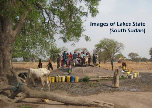
Images of Lakes State (South Sudan) - MetaMeta
Images of Lakes State (South Sudan) - MetaMeta
Images of Lakes State (South Sudan) - MetaMeta

You also want an ePaper? Increase the reach of your titles
YUMPU automatically turns print PDFs into web optimized ePapers that Google loves.
<strong>Images</strong> <strong>of</strong> <strong>Lakes</strong> <strong>State</strong><br />
(<strong>South</strong> <strong>Sudan</strong>)
Introduction<br />
This booklet intends to give a snap-shot <strong>of</strong> <strong>Lakes</strong><br />
<strong>State</strong> in <strong>South</strong> <strong>Sudan</strong>. Located in the centre <strong>of</strong> <strong>South</strong><br />
<strong>Sudan</strong> <strong>Lakes</strong> represent much <strong>of</strong> the challenges<br />
and strengths <strong>of</strong> the world’s newest country:<br />
dynamic and traditional; abundant potential but<br />
a delicate resource system; rich in livestock yet also<br />
food insecure; an area in rapid transformation. As<br />
snapshots go the story is told in pictures - on people,<br />
their economy; the resources and the support systems.<br />
Jetze Heun and Frank van Steenbergen
Making basket<br />
Two women<br />
Popularity <strong>of</strong> bikes<br />
Village life<br />
Population<br />
According to the <strong>South</strong><br />
<strong>Sudan</strong> Centre for Census,<br />
Statisctics, and Evaluation<br />
(SSCCSE) <strong>Lakes</strong> <strong>State</strong> covers<br />
approximately 40,235 Km 2 .<br />
There are a projected<br />
807,203 people in <strong>Lakes</strong> <strong>State</strong><br />
(91 % rural). The population<br />
in <strong>Lakes</strong> is composed mainly<br />
<strong>of</strong> Dinka, Atuot and Jur tribal<br />
groupings. The Dinka and<br />
Atuot are agro-pastoralists,<br />
whereas the Jur are<br />
sedentary farmers.<br />
The population is very young:<br />
50 % is less than 18 years<br />
old. According to the <strong>South</strong><br />
<strong>Sudan</strong> Bureau <strong>of</strong> Statistics<br />
49 % <strong>of</strong> the population is<br />
below the poverty line.<br />
The economy is large<br />
non-monetized: 51 % <strong>of</strong><br />
households did not have any<br />
monetary transaction in the<br />
week prior to the statistical<br />
survey.
Boys<br />
Market in mobile phones<br />
Cooking
Black cotton flood plains in Awerial<br />
Landscapes<br />
In the flat floodplain<br />
area small differences<br />
matter considerably in<br />
the landscape. The main<br />
distinction is between the<br />
flood plains and the slightly<br />
higher crop and land and<br />
forest land. Within the<br />
floodplain soil types and<br />
their capacity to store water<br />
matter a lot.<br />
The drying <strong>of</strong> the<br />
area is manifest in the<br />
encroachment <strong>of</strong> trees <strong>of</strong><br />
previously completely open<br />
grazing areas.
Burnt grass in river flood plain in Billing<br />
Savannah wood and grass land
Ngok Yak draining to<br />
North (Rumbek North)<br />
Baar Gill<br />
Paye (Yei) river<br />
Gul Mar at Kubur William<br />
Makal, branch <strong>of</strong> Baar Gill<br />
Rivers<br />
The rivers shaping <strong>Lakes</strong><br />
<strong>State</strong> originate from the Nile-<br />
Congo Divide. The rivers end<br />
in the extensive flood plains<br />
<strong>of</strong> the northern regions <strong>of</strong><br />
<strong>Lakes</strong> <strong>State</strong>. Typically they do<br />
not reach the Bahr El Jebel<br />
and Bahr El Ghazal during the<br />
flood season, but drain into<br />
these main rivers once water<br />
levels are lowered in the dry<br />
season.<br />
There is a clear distinction<br />
between the wet season<br />
(June-November) and dry<br />
season (December-May).<br />
At the end <strong>of</strong> the dry season<br />
rivers turn ephemeral. Rainfall<br />
patterns have changed.<br />
The rainy season is now<br />
starting later and total rainfall<br />
amounts have reduced with<br />
an estimated 20 % compared<br />
to the period 1980-2000.
Baar Naam upstream at Mvolo<br />
Baar Naam upstream in Billing Floodplain<br />
Baar Naam Midstream at Main Brigde<br />
Tail end Baar Naam at Lake Akew
<strong>Lakes</strong><br />
There are a large number<br />
<strong>of</strong> seasonal wetlands and a<br />
number <strong>of</strong> permanent lakes:<br />
Lake Yirol and Lake Nyubor.<br />
The toic grazing areas around<br />
the lakes are the last resort for<br />
the massive cattle population<br />
in the dry season.<br />
Luil (inlet) into Lak Yirol<br />
Lake Naibour
Effect on soil moisture on both sides <strong>of</strong> the road<br />
Roads, no culvert<br />
Culvert<br />
Culverts should have been provided<br />
Roads<br />
There has been<br />
considerable progress<br />
in road development in<br />
<strong>Lakes</strong> <strong>State</strong>, with much<br />
work on the trunk roads.<br />
At present the emphasis<br />
is on the development <strong>of</strong><br />
feeder road. Roads help<br />
to extend security, yet their<br />
maintenance is a major<br />
challenge. Roads also<br />
affect surface hydrology.<br />
Particularly when cross<br />
drainage is in adequate<br />
roads can have a large<br />
effect on the soil moisture<br />
in the landscape and the<br />
functioning <strong>of</strong> local streams.
Traditional village well<br />
Collecting water from sandhole<br />
Collecting water from<br />
remote pond; the river<br />
is too murky as cattle<br />
uses it Bees competing for drinking water<br />
Drinking Water<br />
Much progress has been<br />
made in the provision <strong>of</strong> safe<br />
drinking water -dating back<br />
from the war, but coverage<br />
and sustainability remain<br />
large challenges. According<br />
to the <strong>South</strong> <strong>Sudan</strong> Bureau<br />
<strong>of</strong> Statistics 71 % <strong>of</strong> the<br />
population has access to<br />
safe water sources, but this<br />
may far less.<br />
There are clear problem<br />
spots. In part <strong>of</strong> Cueibet<br />
the water scarcity and<br />
competiton with bees is so<br />
severe that entire families<br />
move out in the dry period.<br />
In Yirol the population <strong>of</strong> the<br />
town more than doubles<br />
in this season by ‘water’<br />
refugees. Another health<br />
problem is the practice <strong>of</strong><br />
using pools in the wet season.<br />
This is one reason that guinea<br />
worm still persists.
Chinese contractor drilling well Mark 2 pump
Borrow pit from roads<br />
Site for creating storage in Rumbek North<br />
Storage<br />
There is a need to increase<br />
water storage for the dry<br />
season - so as to spread the<br />
pressure on grazing land and<br />
provide water for horticulture.<br />
This may be small storages<br />
similar to the road side ponds.<br />
On the other hand some<br />
<strong>of</strong> the hafirs that are under<br />
development in various<br />
programmes appear to be<br />
overengineered.
Modernized Hafir; excavation on-going<br />
Hafir in Yirol; design errors<br />
Modernized Hafir; fence, pumpstation, cattle throughs
County commissioner interrogating suspected (but innocent) cattle thieves<br />
Security<br />
Security remains a<br />
paramount concern. In<br />
<strong>Lakes</strong> <strong>State</strong> disarmament<br />
has taken place with<br />
strong involvement <strong>of</strong> local<br />
leadership registering arms<br />
and hosting the SPLA to<br />
collect weapons. There<br />
is investment in roads,<br />
government buildings and<br />
police posts, to extend<br />
the reach <strong>of</strong> government<br />
authority.<br />
Insecurity now <strong>of</strong>ten related<br />
to local invidivual conflicts,<br />
that risk to escalate into<br />
larger conflicts. This is<br />
particularly so when many<br />
people are congested in a<br />
small area. Other conflicts<br />
are more directly related to<br />
access to land and water, for<br />
instance the encroachment<br />
<strong>of</strong> farm land by livestock or<br />
the use <strong>of</strong> grazing areas.
New security outpost in Lake Naibour New country commissioners <strong>of</strong>fice in Mapei<br />
Chiefs large role in disarmement Dinka agaar at Mvolo, peaceful return after conflict
Farming by women mainly<br />
Agriculture:<br />
Staple Crops<br />
Crop production in <strong>Lakes</strong> is<br />
largely for self subsistence.<br />
Main crops in <strong>Lakes</strong> are rainfed:<br />
sorghum -intermixed<br />
with sesame seed, bulrush<br />
millet, cowpeas and greengram<br />
(lentils). A second<br />
main crop is groundnut.<br />
There are various land races<br />
<strong>of</strong> sorghum, short duration<br />
(three months) and long<br />
duration (six to nine months).<br />
The long duration varieties<br />
are preferred because they<br />
Picture left:<br />
The common practice is<br />
to clear an area and grow<br />
the crops for a number <strong>of</strong><br />
years. After this period a new<br />
area is cleared, with the<br />
individual family moving to<br />
the new area. This slash and<br />
burn practice adds fertility<br />
to the soil but it is argued<br />
that with ‘slash and char’<br />
soil improvement would be<br />
far more longer lasting as<br />
the bio char would improve<br />
water retention capacity and<br />
would enhance microbial<br />
action.
are less susceptible to bird<br />
damage and post harvest<br />
losses and have better taste.<br />
The advantage <strong>of</strong> short<br />
duration varieties, however, is<br />
that they are less susceptible<br />
to failure in the rainy season.<br />
They produce early and<br />
hence mean an end to the<br />
‘hunger season’.<br />
There is between 65,000<br />
and 80,000 hectares under<br />
cultivation in <strong>Lakes</strong> <strong>State</strong>.<br />
Land is traditionally prepared<br />
manually, soon after the<br />
onset <strong>of</strong> rain. Oxploughs have<br />
been strongly promoted<br />
in the last five years. They<br />
allow the farm area to<br />
expand considerably, to<br />
store moisture deeper (and<br />
make it last longer after the<br />
rains are over) and put the<br />
seeds deeper, so they are<br />
less prone to wash outs. The<br />
oxploughs are important<br />
because - due to the later<br />
rains - the season for land<br />
preparations has shortened.<br />
Cowpeas and sorghum, two main crops Pounding <strong>of</strong> sorghum, very labour<br />
intensive<br />
Much to gain in improved storage<br />
Introduction <strong>of</strong> oxplough more than doubled farm acreage<br />
Clearing land for<br />
cultivation, compiling<br />
wood for burn
Experimental greenhouse<br />
Small drains in flood plains for vegetable cultivation<br />
Vegetables and fruits at Rumbek Market - largely<br />
imported from Uganda<br />
Agriculture:<br />
Gardening<br />
There is at present only very<br />
scattered irrigation. This<br />
consists <strong>of</strong> small vegetable<br />
gardens cultivated with<br />
water from hand pumps,<br />
storage ponds or lakeside<br />
moisture. Much <strong>of</strong> this<br />
horticulture is by women<br />
groups. There is almost no<br />
cultivation in the flood plain.
Market gardening by women from water pond
Milk is main food item<br />
Cattle herders at toic<br />
Cattle on the move<br />
Cattle<br />
Lake <strong>State</strong> is a cattle<br />
producing state. The number<br />
<strong>of</strong> cattle is estimated<br />
by FAO at 1,365,000 yet<br />
estimating is difficult. The<br />
main livestock product is<br />
milk. This also constitutes the<br />
main diet item. Livestock is<br />
tradititonally the mayor sole<br />
source <strong>of</strong> prestige among<br />
the cattle-keeping groups<br />
in <strong>Lakes</strong> <strong>State</strong>: Dinka culture<br />
in particular centers around<br />
cattle and life revolves<br />
around the cattle camps.<br />
Cattle is also the currency for<br />
marriage arrangements, fines<br />
and other social transactions.<br />
It hardly is an economic<br />
commodity.<br />
Cattle population in <strong>Lakes</strong> is<br />
assessed to have increased<br />
very significantly, with<br />
increased stability and<br />
the control <strong>of</strong> main cattle<br />
diseases. Where there<br />
were few cattle camps ten<br />
years ago, there are many<br />
now. Dowry payments as<br />
expressed in number <strong>of</strong> cattle<br />
have increased.
Young boys<br />
Live in the cattle camp - each animal its own peg<br />
Young men
There is a strong relation<br />
between cattle keeping<br />
and water resources. The<br />
use <strong>of</strong> grazing areas is very<br />
much determined by the<br />
availability <strong>of</strong> water and the<br />
development <strong>of</strong> dry matter is<br />
also dependent on sufficient<br />
intake <strong>of</strong> water. Cattle can<br />
roam 4-5 kilometer from the<br />
watering point, and the use<br />
<strong>of</strong> a grazing area hence<br />
depends on the availability<br />
<strong>of</strong> water, particularly in the<br />
dry season (December-<br />
May). There are more over<br />
several areas in <strong>Lakes</strong> <strong>State</strong><br />
where there is ample grass<br />
for grazing but no water<br />
storage. During the dry<br />
season water sources dry up<br />
(through evaporation and<br />
consumption by cattle) and<br />
pastoralist movement to<br />
cattle camps is related to the<br />
vicinity <strong>of</strong> water resources.<br />
Where water is intensely<br />
used the quality deteriorates<br />
and the turbidity increases<br />
In some areas thick mud<br />
layers in water bodes is a<br />
major problem causing cattle<br />
injuries.<br />
Cattle drinking from Paye River
Auctioneer at the cattle market<br />
Regulatory committee at cattle auction<br />
Selling and buying (from the fence) cattle<br />
Cattle Auction<br />
There is contrast between<br />
the large symbolical wealth<br />
<strong>of</strong> cattle on one hand and<br />
the very persistent poverty<br />
on the other hand. Cattle<br />
sales, unless forced by<br />
circumstances is still unusual<br />
and taboo, though the<br />
domestic livestock market<br />
is growing. There are eight<br />
cattle auctions in the state.<br />
Marketing <strong>of</strong> livestock<br />
through the auctions<br />
has improved, though<br />
transactions do not cover<br />
more than 5 % <strong>of</strong> all cattle<br />
that is changing hands.
Tuot - also used for brooms<br />
A peach grass<br />
Nuonluo - preferred grass<br />
Grass<br />
In order <strong>of</strong> preference <strong>of</strong><br />
cattle keepers the main<br />
grasses are: [1] nuonlo, [2] a<br />
peach and [3] tuot.<br />
Nuonluo is also used for<br />
thatch and needs to be<br />
bruned to regenerate and<br />
be palatable. A peach has<br />
a low ground cover and<br />
<strong>of</strong>ten surface when swamps<br />
recline. Tuot is vulnerable to<br />
being submerged in floods,<br />
this will cause it to stop<br />
growing. Tuot is also used for<br />
brooms.
Burning grassland to rejuvenate in time<br />
Toic (dried swamp) grazing area<br />
Harvesting thatch from nuonluo
Catching mudfish<br />
Fisheries<br />
Fisheries are a source <strong>of</strong><br />
protein in <strong>Lakes</strong> <strong>State</strong>,<br />
especially for those living<br />
close to the rivers and lakes.<br />
About 13 % <strong>of</strong> the population<br />
in <strong>Lakes</strong> is involved in fishing,<br />
and 40 % <strong>of</strong> these sell at least<br />
part <strong>of</strong> the landings. The<br />
fishing grounds have their<br />
origin in two fish movements<br />
(north-south and south-north)<br />
coming together in the area.<br />
Fishing is artisanal using very<br />
simple equipment and postcatch<br />
losses are high. The<br />
disruption <strong>of</strong> river flows in<br />
the longer dry season has<br />
affected fish migration and<br />
fish stocks.
Fishing with fishing spears Fishing with throw net
Fish trap from Lake Yirol<br />
Fishing nets are scarce and hard to get Dried fish at the market<br />
Fresh fish at the market
Store <strong>of</strong> world food program Surviving on wild fruits in the hunger season<br />
Food aid<br />
Of the total population 13 %<br />
is estimated to be severrely<br />
food insecure and 28 %<br />
moderately food insecure.<br />
This puts <strong>State</strong>s in the lower<br />
bracket <strong>of</strong> food insecure<br />
areas in <strong>South</strong> <strong>Sudan</strong>.<br />
Considerable food aid keeps<br />
going tto the Lake <strong>State</strong>. In<br />
2012 the import <strong>of</strong> sorghum<br />
by WFP is likely to equal or<br />
even exceed the 45,000 MT<br />
local production.
Gom acacia - abundant but not tapped into<br />
Preparing charcoal for the Juba Market<br />
Trees<br />
Trees are important in<br />
overcoming the ‘hunger<br />
season’ that starts at the end<br />
<strong>of</strong> the dry season and lasts till<br />
the first harvests are in. There<br />
is commercial potential in<br />
developing tree crops.<br />
[1] <strong>Lakes</strong> <strong>State</strong> has a large<br />
natura stands <strong>of</strong> lulu sheanut<br />
trees (Vitellaria Nilotica). This<br />
sheanut butter is quality-wise<br />
superior to the more popular<br />
sheanut butter from West<br />
Africa.<br />
[2] There are large<br />
unexploited stands <strong>of</strong> gum<br />
acacia trees (Acacia<br />
Seyal). [3] Wild mango and<br />
medicinal plants have much<br />
promise.
Scarce ebony wood<br />
Lulu (sheanut) important food in the hunger season
Wildlife<br />
The wetlands <strong>of</strong> <strong>Lakes</strong><br />
attract considerable bird<br />
life. There have been many<br />
changes too. Significant is<br />
the withdrawal <strong>of</strong> hippostoa<br />
mich smaller habitat, mainly<br />
Lake Nyubor. Earlier hippos<br />
were found in most rivers and<br />
streams, their movement<br />
helping to keep the depth <strong>of</strong><br />
the rivers. Also the diversity <strong>of</strong><br />
fish species in rivers is said to<br />
have decreased.
Col<strong>of</strong>on<br />
Text and photos by Jetze Heun and Frank<br />
van Steenbergen. Printing is funded from<br />
DUPC Fund and complements the water<br />
identification mission undertaken with<br />
support <strong>of</strong> the WATER OS Programme <strong>of</strong><br />
Ministry <strong>of</strong> Foreign Affairs/DGIS DME and<br />
NWP.<br />
The ideas <strong>of</strong> several people but<br />
especially Dr. Yath Dut and Engineer<br />
Deng Santino <strong>of</strong> the MWRI are<br />
acknowledged.<br />
Layout by Linda Navis.<br />
www.metameta.nl<br />
www.unesco-ihe.org<br />
Contact: lnavis@metameta.nl