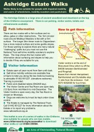
Ashridge Drovers Walk - The Chilterns
Ashridge Drovers Walk - The Chilterns
Ashridge Drovers Walk - The Chilterns

You also want an ePaper? Increase the reach of your titles
YUMPU automatically turns print PDFs into web optimized ePapers that Google loves.
<strong>The</strong> <strong>Ashridge</strong> Estate covers 6 square miles of woodlands,<br />
commons, downland and farmland in Hertfordshire and<br />
Buckinghamshire. Most of this land is open access to the public<br />
and is owned and managed by the National Trust. <strong>The</strong> area<br />
supports an amazing diversity of birdlife including goldcrest<br />
and the lesser-spotted woodpecker. Wild fallow deer are a<br />
common sight and muntjac deer, badgers and the rarely found<br />
dormouse are also resident. <strong>The</strong> main focal point of the Estate<br />
is the granite Monument erected in 1832 to the 3rd Duke of<br />
Bridgewater, the Canal Duke.<br />
<strong>The</strong> <strong>Ashridge</strong> <strong>Drovers</strong> <strong>Walk</strong><br />
<strong>The</strong> <strong>Ashridge</strong> <strong>Drovers</strong> <strong>Walk</strong> follows typically Chiltern sunken lanes<br />
that criss-cross the area. This network of ancient green lanes<br />
would have been used over hundreds of years to move livestock<br />
from the villages of Aldbury, Ivinghoe and Pitstone to their<br />
common lands. This movement of livestock was called droving.<br />
<strong>The</strong> paths used for droving had to be wide enough to<br />
accommodate cattle at least two abreast. You will notice on<br />
several paths that ancient hedgebanks and ditches with steep<br />
sides often enclose the paths. <strong>The</strong>se sunken tracks are known as<br />
hollow-ways and many of the routes on this walk are informally<br />
known by descriptive names, such as ‘Back Hollow.’<br />
Much of this walk is through common land. Common land is<br />
unusual, insofar as the ‘commoners’ have rights to grazing and<br />
other activities, such as cutting turf, although they are not the<br />
owners of that land. <strong>The</strong>re are very few commoners left today. <strong>The</strong><br />
three villages surrounding the <strong>Ashridge</strong> Estate, Pitstone, Ivinghoe<br />
and Aldbury, have their respective commons within the Estate.<br />
<strong>The</strong>se three commons would have been clear of woodland as<br />
recently as one hundred years ago. <strong>The</strong> commons within <strong>Ashridge</strong><br />
were then used to graze cattle, sheep and pigs from the adjacent<br />
villages. Fuel for heating homes was also collected from the<br />
commons along with bedding for animals and heather and birch<br />
for making brooms.<br />
Most commons were heavily grazed and, over the centuries, lost<br />
their woodland cover except for a few large trees. <strong>The</strong>re has been<br />
very little grazing in the last hundred years and, as a result, many<br />
commons have been re-colonised by woodland. What you see<br />
today is a mixture of open grassland, ancient trees and relatively<br />
new woodlands.<br />
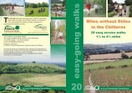
This is one of a series of walks through the <strong>Chilterns</strong> Area<br />
of Outstanding Natural Beauty (AONB). It follows rights of<br />
way most of which are waymarked as follows:<br />
Footpath (walkers only)<br />
Bridleway (horse riders, cyclists and walkers)<br />
Byway open to all traffic<br />
Restricted Byway (horseriders, cyclists, walkers<br />
and non-mechanically propelled vehicles)<br />
Please be considerate in the countryside - keep to<br />
footpaths, especially through crops, and leave farm<br />
gates as you find them.<br />
Refreshments are available on the walk route in the village of<br />
Aldbury or at the Visitor Centre at the Bridgewater Monument,<br />
tel. 01442 851227<br />
Refreshments and B&B in the historic village of Aldbury:<br />
<strong>The</strong> Valiant Trooper: friendly pub, traditional English cooking.<br />
Food served all day every day, specials on blackboard.<br />
Tel. 01442 851203<br />
<strong>The</strong> Greyhound Inn: Small, family-run country hotel and top<br />
local restaurant. Tel. 01442 851228 www.greyhoundaldbury.co.uk<br />
For further walks and rides in the area visit<br />
www.chilternsaonb.org/activities.asp<br />
01727 848168<br />
www.hertslink.org/cms<br />
www.chilternsaonb.org<br />
Tel: 01844 355504<br />
www.chilternsociety.org.uk<br />
<strong>Chilterns</strong> Country<br />
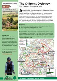
<strong>The</strong> <strong>Ashridge</strong> <strong>Drovers</strong> <strong>Walk</strong><br />
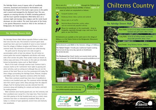
Short <strong>Walk</strong>: 6.5 km (4 m) rolling wooded countryside,<br />
farmland and golf course, allow 2 hours<br />
Long <strong>Walk</strong>: 10 km (6 m) rolling wooded countryside,<br />
steep chalk grassland, allow 3 hours<br />
Start / Finish: Tring Railway Station, Aldbury<br />
AREA OF OUTSTANDING NATURAL BEAUTY
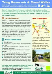
How to get to Tring Station<br />
Tring railway station is on the London, Euston to Birmingham line. <strong>The</strong><br />
Grand Union Canal towpath links Hemel Hempstead and Berkhamsted<br />
with Tring Station for walkers and cyclists. Cyclists can use the towpath<br />
but should obtain a cycle permit from British Waterways on 01908<br />
302500. <strong>The</strong>re are buses to Tring Station Monday to Saturday from<br />
Berkhamsted and Hemel Hempsted to (no. 30) and from Tring and Aldbury<br />
(no. 387). In addition, the <strong>Chilterns</strong> Rambler bus (327) operates on<br />
Sundays and Bank Holidays from April to September. For bus and train<br />
information call Traveline 0871 200 22 33 www.traveline.info<br />
If you need to come by car, please park in Tring railway station Long Stay<br />
car park, there is no parking in Aldbury. Tring Station is 2.5 km east of<br />
Tring and signposted from the A4251. Parking is £5 except on Sundays<br />
when it is free.<br />
Notes on the walk going anticlockwise<br />
From Tring Station turn right. Follow Station Road, after the<br />
junction take a track left over a cattle grid and continue<br />
straight on at a junction of bridleways. Turn right onto a<br />
footpath leading into Aldbury.<br />
Follow the path, past farm buildings on your right and a<br />
pond on your left, continuing straight on to the road. Turn<br />
left towards Aldbury, past the church and straight across the<br />
crossroads, with the village pond on your left on to Toms Hill<br />
Road. After 30 metres take the bridleway on the left<br />
signposted 'Bridgewater Monument 1/2', it is quite a steep<br />
climb. At the top, skirt around the green until the<br />
Bridgewater Monument is on your left, take the <strong>Ashridge</strong><br />
Boundary Trail on the right.<br />
For the shorter walk , turn left onto a footpath and descend<br />
out of the woods into farmland. After crossing Stocks Road,<br />
follow a bridlepath through <strong>Walk</strong> Wood onto Stocks Golf<br />
Course. <strong>The</strong> path goes around the outside edge of the golf<br />
course and meets up with the bridleway you first took from<br />
Tring Station.<br />
For the longer walk , continue to follow waymarks for the<br />
<strong>Ashridge</strong> Boundary Trail. After 1.5 miles, the waymarked path<br />
forks left from the stony track, following the woodland edge<br />
and across open downland to meet the Ridgeway. Turn left<br />
on to the Ridgeway.<br />
Follow the Ridgeway National Trail’s distinctive black<br />
fingerposts, bearing an acorn, over Pitstone Hill and through<br />
Aldbury Nowers back to Station Road. <strong>The</strong> Ridgeway National<br />
Trail follows much of what is thought to be Britain’s oldest<br />
road. Starting in Wiltshire, it travels for 137 km passing<br />
through the <strong>Chilterns</strong> to finish at Ivinghoe Beacon.<br />
key<br />
<strong>Ashridge</strong> <strong>Drovers</strong> walk (short)<br />
<strong>Ashridge</strong> <strong>Drovers</strong> walk (long)<br />
Pitstone Hill<br />
Aldbury<br />
Nowers<br />
Stocks<br />
Golf Course<br />
N<br />
<strong>Walk</strong> Wood<br />
ALDBURY<br />
Pitstone<br />
Common<br />
Ivinghoe<br />
Common<br />
Aldbury<br />
Common<br />
scale: 1 kilometre <strong>Walk</strong>ing gets you fit and keeps you healthy